Lucas fielding (14 Ergebnisse)

- Softcover
Anbieter: Ria Christie Collections, Uxbridge, Vereinigtes KönigreichRia Christie Collections
Verkäufer/-in kontaktierenVerkäufer/-in mit 5 SternenZustand: Neu
EUR 39,62
EUR 13,98 VersandVersand von Vereinigtes Königreich nach USAAnzahl: Mehr als 20 verfügbar
Zustand: New. In.
 Weitere Bilder
Sprache: Deutsch
Verlag: CORA Verlag, Hamburg, 2018
- Softcover
Anbieter: Butterfly Books GmbH & Co. KG, Herzebrock-Clarholz, DeutschlandButterfly Books GmbH & Co. KG
Verkäufer/-in kontaktierenVerkäufer/-in mit 5 SternenZustand: Gebraucht - Sehr gut
EUR 24,00
EUR 60,00 VersandVersand von Deutschland nach USAAnzahl: 1 verfügbar
Softcover. Zustand: Sehr gut. Band 444. 123 Seiten Eine Sammlung romantischer Geschichten verschiedener Autorinnen, die sich um Verführung und Leidenschaft drehen. Zustand: Einband mit geringfügigen Gebrauchsspuren, insgesamt SEHR GUTER Zustand! HC1-584-6/8-00597615 Sprache: Deutsch Gewicht in Gramm: 243.
 Weitere Bilder
Verlag: Published by Carey & Lea, Philadelphia, 1822
- Karte
Anbieter: Blind-Horse-Books (ABAA), DeLand, FL, USABlind-Horse-Books (ABAA)
Verkäufer/-in kontaktierenVerkäufer/-in mit 5 SternenZustand: Gebraucht - Gut
EUR 112,55
EUR 5,24 VersandVersand innerhalb von USAAnzahl: 1 verfügbar
Zustand: Very Good. A sophisticated cartographic study of the northern Caribbean at a political flashpoint, produced during the height of Spanish colonial tension and the rise of Bolivar?s influence.? This map, plate 40 from the landmark Carey & Lea atlas, provides an exceptionally detailed look at the Bahamian archipelago and t…he rugged interior topography of Cuba. By surrounding the copperplate engraving with dense, encyclopedic columns of text, Fielding Lucas Jr. created a 'total document' that served as a primary intelligence briefing for 1820s American merchants and diplomats navigating the complex social and economic structures of the West Indies. KEY FEATURES +++ Visuals: Hand-colored engraving featuring pictorial mountains in the Cuban interior and detailed bathymetry of the Great Bahama Bank. Notable for marking Cat Island as the 1492 landfall of Columbus. +++ Binding: Disbound from the 1822 'Complete Historical, Chronological, and Geographical American Atlas'; vertical center-fold as issued. +++ Content: Extensive text blocks covering the government, climate, and soil of Cuba and the Bahamas, including historical sketches of Spanish and British administration. +++ Imprint: Philadelphia: Published by Carey & Lea, 1822. Engraved by Young & Delleker. +++ Specs: Full sheet measures 22 x 17.5 inches; map image 16.5 x 12 inches. CONDITION - A nice, bright impression with typical light age-toning across the sheet. The hand-coloring is well-preserved. There are two distinct dark spots located just below the bottom map border in the lower margin; these do not affect the cartographic image or the primary text. The original center-fold is strong. Overall a clean, stable specimen of early 19th-century American copperplate printing. SCHOLARLY FEATURES +++ Abolitionist Context: The text and map provide a snapshot of the Bahamas during its era as a destination for escaped slaves from Florida, offering a geographical look at the 'Maroon' and maritime escape routes of the period. +++ Geopolitical Transition: Captures Cuba during the 'Spanish colonial oppression' mentioned in contemporary accounts, just as the successes of Simon Bolivar were beginning to inspire regional revolutionary sentiment. +++ Hydrographic Detail: One of the most detailed commercial renderings of the Bahamian sand banks and navigational hazards available to the 1822 public. HISTORICAL SIGNIFICANCE ? Fielding Lucas Jr. was the most meticulous American mapmaker of the early 19th century. His work for Carey & Lea was revolutionary because it adopted the 'Lesage' style?integrating high-level statistics directly onto the map sheet. This allowed the viewer to understand not just where Cuba was, but its population density, agricultural output, and colonial history in a single glance. In 1822, the Bahamas remained a critical British strategic outpost, while Cuba was the 'Jewel of the Antilles' for the Spanish Crown. This map demonstrates the 'interconnection' of these islands, highlighting how their proximity shaped the trade and defense of the American South and the Gulf of Mexico. SUBJECTS: Cuba, Bahama Islands, Spanish Colonialism, British West Indies, Cartography, 19th-Century Statistics, Bolivar, Maritime History, Antique Map, Engraving, Americana. BIBLIOGRAPHIC REFERENCE: Phillips 1373a; Howes C133; Rumsey CM1794.

Verlag: Lucas, Fielding, London, 1824
Anbieter: Argosy Book Store, ABAA, ILAB, New York, NY, USAArgosy Book Store, ABAA, ILAB
Verkäufer/-in kontaktierenVerkäufer/-in mit 5 SternenZustand: Gebraucht
EUR 112,55
EUR 5,24 VersandVersand innerhalb von USAAnzahl: 1 verfügbar
unbound. Map. Engraving with original hand coloring. Image measures 11 1/2" x 9 1/4" Classic 19th century map of Peru, hand-colored by region. Rivers, cities, mountain ranges, and lakes are labeled. Various indigenous groups are indicated, mostly in the eastern half of the country, in the regions they inhabit. In excellent condi…tion. Fielding Lucas Jr. was an artist, publisher and cartographer active in the early 19th century. He published his first atlas in 1815 and became known as the earliest successful commercial map publisher in Baltimore. He was also the first stationer in the United States. His son, William Lucas took over the printing and stationery business shortly after his death.

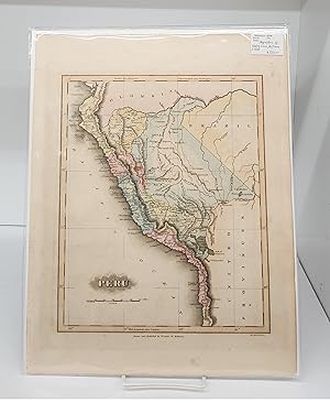
Verlag: Lucas, Fielding, London, 1824
Anbieter: Argosy Book Store, ABAA, ILAB, New York, NY, USAArgosy Book Store, ABAA, ILAB
Verkäufer/-in kontaktierenVerkäufer/-in mit 5 SternenZustand: Gebraucht - Gut
EUR 112,55
EUR 5,24 VersandVersand innerhalb von USAAnzahl: 1 verfügbar
unbound. Zustand: very good(+). Map. Engraving with original hand coloring. Image measures 8.75" x 10.5". Charming map of the Cape Verde Islands. Small tear to left edge and minor chip to bottom edge. Fielding Lucas Jr. was an artist, publisher and cartographer active in the early 19th century. He published his first atlas in 18…15 and became known as the earliest successful commercial map publisher in Baltimore. He was also the first stationer in the United States. His son, William Lucas took over the printing and stationery business shortly after his death.
 Weitere Bilder
Verlag: Carey & Lea, Philadelphia, 1822
- Karte
Anbieter: Blind-Horse-Books (ABAA), DeLand, FL, USABlind-Horse-Books (ABAA)
Verkäufer/-in kontaktierenVerkäufer/-in mit 5 SternenZustand: Gebraucht - Gut
EUR 157,57
EUR 5,24 VersandVersand innerhalb von USAAnzahl: 1 verfügbar
Zustand: Very Good. A foundational specimen of American commercial cartography, this map represents the peak of 19th-century geographical reporting during a period of intense colonial transition.? Drawn by Fielding Lucas Jr. and appearing in the landmark 'Complete Historical, Chronological, and Geographical American Atlas', the…work utilizes the 'Lesage' style of surrounding a central map with dense columns of demographic and historical data. By coding the islands in distinctive hand-colored washes?red for British, yellow for Spanish, and green for Dutch?Lucas provides a visual ledger of the waning European grip on the Americas just as regional independence movements began to reshape the Western Hemisphere. KEY FEATURES +++ Visuals: Hand-colored copperplate engraving featuring intricate coastal details, navigational hazards, and shoals. Includes the site of Columbus' 1492 landing noted on Cat Island. +++ Binding: Disbound from the original 1822 atlas; retains the original vertical center-fold. +++ Content: Extensive narrative text columns detailing climate, soil, government, and the religious profile of the islands (Haiti, Cuba, Jamaica, Puerto Rico, etc.). +++ Imprint: Philadelphia: Published by Carey & Lea, 1822. Engraved by Young & Delleker. +++ Specs: Full sheet measures 22 x 17.5 inches; map image 16.5 x 12 inches. CONDITION: A bright impression with light, even age-toning across the sheet. The original hand-coloring remains vibrant. There is a standard center-fold from the original atlas binding, which is structurally sound. The margins are generous, showing only minor shelf handling and negligible soiling to the outer edges. A well-preserved, unsophisticated example of early American atlas printing. SCHOLARLY FEATURES +++ Colonial Ledger: The map functions as a primary political document, categorizing the Caribbean not by geography, but by European ownership during the era of the Monroe Doctrine. +++ Demographic Data: The statistical tables provide a 'timestamp' of the region's population and slave labor systems just prior to the major waves of British emancipation. +++ Navigational Detail: While interior topography is scarce, the coastal work is exceptionally detailed, noting keys and banks that were essential for the era?s maritime trade routes. HISTORICAL SIGNIFICANCE ? Fielding Lucas Jr. was the premier American cartographer of his era, and his work for the Carey & Lea Atlas solidified Philadelphia as the center of the American publishing world. This atlas was the first of its kind produced in the United States to rival the great European houses, and it remains a cornerstone for collectors of Western Hemisphere geography. The year 1822 was a time of immense political upheaval. As the United States looked southward, this map provided the necessary 'intelligence' for merchants and politicians to understand the complex web of Caribbean interests. The inclusion of lengthy text blocks allowed the 19th-century reader to move beyond the image into a deep-dive of the region's economic possibilities. SUBJECTS: West Indies, Caribbean History, Colonialism, Cartography, Philadelphia Publishing, 19th-Century Statistics, Maritime History, Antique Map, Engraving, Americana. BIBLIOGRAPHIC REFERENCE: Phillips 1373a; Howes C133; Rumsey CM1794.

Verlag: Baltimore, 1823, 1823
Anbieter: Pennymead Books PBFA, Knaresborough, Vereinigtes KönigreichPennymead Books PBFA
Verkäufer/-in kontaktierenVerkäufer/-in mit 5 SternenVerbandsmitglied: PBFA
Zustand: Gebraucht
EUR 220,21
EUR 17,51 VersandVersand von Vereinigtes Königreich nach USAAnzahl: 1 verfügbar
Engraved map, 12 x 9" with wide margins. Original wash colour with later heightening. Fine.
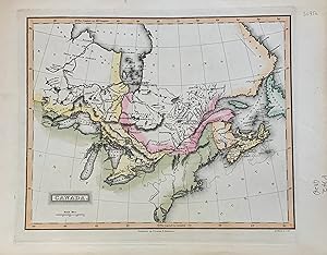
Verlag: Lucas, Fielding, Baltimore, 1824
Anbieter: Argosy Book Store, ABAA, ILAB, New York, NY, USAArgosy Book Store, ABAA, ILAB
Verkäufer/-in kontaktierenVerkäufer/-in mit 5 SternenZustand: Gebraucht
EUR 238,60
EUR 5,24 VersandVersand innerhalb von USAAnzahl: 1 verfügbar
unbound. Map. Engraving with original hand coloring. Image measures 9 x 11 inches Beautiful early map of Canada from Lake of the Woods in Manitoba to Labrador. Centered on the Great Lakes which are shown it their entirety. Includes part of Newfoundland and New England. Many tribal territories are noted. Scale in British miles. I…n good condition small chips to margin but not affecting image. Fielding Lucas Jr. was an artist, publisher and cartographer active in the early 19th century. He published his first atlas in 1815 and became known as the earliest successful commercial map publisher in Baltimore. He was also the first stationer in the United States. His son, William Lucas took over the printing and stationery business shortly after his death.

Verlag: Artist: Fielding Lucas :, 1782
- Kunstdruck
Anbieter: Antique Sommer& Sapunaru KG, München, DeutschlandAntique Sommer& Sapunaru KG
Verkäufer/-in kontaktierenVerkäufer/-in mit 4 SternenZustand: Gebraucht
EUR 200,00
EUR 45,00 VersandVersand von Deutschland nach USAAnzahl: 1 verfügbar
Technic: Copper print, colorit: original colored, condition: Perfect condition, size (in cm): 16 x 21 cm, General view of the Hanseatic town of Warburg on the river Diemel.

Verlag: Philadelphia, 1822
Anbieter: Argosy Book Store, ABAA, ILAB, New York, NY, USAArgosy Book Store, ABAA, ILAB
Verkäufer/-in kontaktierenVerkäufer/-in mit 5 SternenZustand: Gebraucht
EUR 270,12
EUR 5,24 VersandVersand innerhalb von USAAnzahl: 1 verfügbar
unbound. Map. Engraving with original hand coloring. Image measures 10.5" x 8.5". Rare map of North America includes Canada, United States, Mexico when most of the South West was still New Spain. Creative inset of "The Caribbee Isles". Shows cities, topographical details and waterway, with Colonial outline coloring. Full origina…l margins with some stains along right edge. Minor spotting. Fielding Lucas Jr. was an artist, publisher and cartographer active in the early 19th century. He published his first atlas in 1815 and became known as the earliest successful commercial map published in Baltimore. He was also the first stationer in the United States. His son, William Lucas took over the printing and stationery business shortly after his death. Henry Schenck Tanner (1786-1858) was an engraver and publisher from New York City. He worked in partnership with his brother in Philadelphia for a few years before breaking off on his own. Tanner is widely considered the first native-born American publisher devoted expressly to maps. This particular map is from the rare Lucas atlas of which, apparently, only two copies are known.

Verlag: Philadelphia
Anbieter: Argosy Book Store, ABAA, ILAB, New York, NY, USAArgosy Book Store, ABAA, ILAB
Verkäufer/-in kontaktierenVerkäufer/-in mit 5 SternenZustand: Gebraucht - Gut
EUR 270,12
EUR 5,24 VersandVersand innerhalb von USAAnzahl: 1 verfügbar
unbound. Zustand: very good(+). Map. Engraving with original hand coloring. Image measures 10.5" x 8.5", sheet measures 13.5" x 10.75". In very good condition. Rare map of North America includes Canada, United States, Mexico when most of the South West was still New Spain. Creative inset of "The Caribbee Isles". Shows cities, to…pographical details and waterways. Fielding Lucas Jr. was an artist, publisher and cartographer active in the early 19th century. He published his first atlas in 1815 and became known as the earliest successful commercial map published in Baltimore. He was also the first stationer in the United States. His son, William Lucas took over the printing and stationery business shortly after his death.
Verlag: ca. 1832, Baltimore, MD, 1832
Anbieter: Attic Books (ABAC, ILAB), London, ON, KanadaAttic Books (ABAC, ILAB)
Verkäufer/-in kontaktierenVerkäufer/-in mit 5 SternenZustand: Gebraucht - Befriedigend
EUR 315,14
EUR 13,11 VersandVersand von Kanada nach USAAnzahl: 1 verfügbar
Zustand: Good. 29 cm map on 38 cm page. Hand coloured later. Fielding Lucas Jr. (1781 1854) was an American cartographer, artist, and publisher prominent during the early 19th century. He is known as the earliest successful commercial map-publisher in the city of Baltimore. He often collaborated with B. T. Welch & Co.
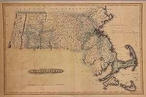
Verlag: B. T. Welch & Co, Baltimore, 1824
Anbieter: Argosy Book Store, ABAA, ILAB, New York, NY, USAArgosy Book Store, ABAA, ILAB
Verkäufer/-in kontaktierenVerkäufer/-in mit 5 SternenZustand: Gebraucht
EUR 360,15
EUR 5,24 VersandVersand innerhalb von USAAnzahl: 1 verfügbar
Map. Engraving with original coloring. Image measures 11 1/2" x 17 1/4". Baltimore: 1824 Early map of Massachusetts divided by counties. Cities, towns, roads, waterways, ponds, and other topographical features are shown. Topography is depicted pictorially. In very good condition, with minor overall toning and offsetting. Some we…ar to margins and original centerfold. Scarce. Fielding Lucas Jr. was an artist, publisher and cartographer active in the early 19th century. He published his first atlas in 1815 and became known as the earliest successful commercial map published in Baltimore. He was also the first stationer in the United States.

Verlag: B. T. Welch & Co, Baltimore, 1824
Anbieter: Argosy Book Store, ABAA, ILAB, New York, NY, USAArgosy Book Store, ABAA, ILAB
Verkäufer/-in kontaktierenVerkäufer/-in mit 5 SternenZustand: Gebraucht
EUR 360,15
EUR 5,24 VersandVersand innerhalb von USAAnzahl: 1 verfügbar
Map. Engraving with original coloring. Image measures 11 1/2" x 8 1/2". Baltimore: 1824 Beautifully colored early map of Rhode Island. Cities, towns, waterways, roads, bridges, and topographical features are labeled. Notably, several 'manufactories' are also labeled, including a ship yard, iron works, and mills. These sites illu…strate the growing industries of the state in the early 19th century. Topography is depicted by hachure. Unusual cube, line interlocking design for the title as well as a unique compass rose design sets the map apart. Fielding Lucas Jr. was an artist, publisher and cartographer active in the early 19th century. He published his first atlas in 1815 and became known as the earliest successful commercial map published in Baltimore. He was also the first stationer in the United States.


