
Gesamtpreis (1 Artikel Artikel):
Versandziel:

fielding lucas (12 Ergebnisse)
Direkt zu den wichtigsten Suchergebnissen
Suchfilter
Produktart
- Alle Product Types
- Bücher (11)
- Magazine & Zeitschriften (Keine weiteren Ergebnisse entsprechen dieser Verfeinerung)
- Comics (Keine weiteren Ergebnisse entsprechen dieser Verfeinerung)
- Noten (Keine weiteren Ergebnisse entsprechen dieser Verfeinerung)
- Kunst, Grafik & Poster (1)
- Fotografien (Keine weiteren Ergebnisse entsprechen dieser Verfeinerung)
- Karten (Keine weiteren Ergebnisse entsprechen dieser Verfeinerung)
- Manuskripte & Papierantiquitäten (Keine weiteren Ergebnisse entsprechen dieser Verfeinerung)
Zustand Mehr dazu
- Neu (1)
- Wie Neu, Sehr Gut oder Gut Bis Sehr Gut (1)
- Gut oder Befriedigend (3)
- Ausreichend oder Schlecht (Keine weiteren Ergebnisse entsprechen dieser Verfeinerung)
- Wie beschrieben (7)
Einband
- alle Einbände
- Hardcover (Keine weiteren Ergebnisse entsprechen dieser Verfeinerung)
- Softcover (2)
Weitere Eigenschaften
- Erstausgabe (Keine weiteren Ergebnisse entsprechen dieser Verfeinerung)
- Signiert (Keine weiteren Ergebnisse entsprechen dieser Verfeinerung)
- Schutzumschlag (Keine weiteren Ergebnisse entsprechen dieser Verfeinerung)
- Angebotsfoto (11)
Sprache (3)
Preis
- Beliebiger Preis
- Weniger als EUR 20 (Keine weiteren Ergebnisse entsprechen dieser Verfeinerung)
- EUR 20 bis EUR 45
- Mehr als EUR 45
Gratisversand
- Kostenloser Versand nach USA (Keine weiteren Ergebnisse entsprechen dieser Verfeinerung)
Land des Verkäufers
Verkäuferbewertung
-

The end of religious controversy: in a friendly correspondence between a religious society of Protestants and a Roman Catholic divine
Anbieter: Ria Christie Collections, Uxbridge, Vereinigtes Königreich
Verkäuferbewertung 5 von 5 Sternen

EUR 39,19
EUR 13,83 Versand
Versand von Vereinigtes Königreich nach USAAnzahl: Mehr als 20 verfügbar
In den WarenkorbZustand: New. In.
-
JULIA EXTRA Juwelen der Versuchung
Sprache: Deutsch
Verlag: CORA Verlag, Hamburg, 2018
Anbieter: Butterfly Books GmbH & Co. KG, Herzebrock-Clarholz, Deutschland
Verkäuferbewertung 5 von 5 Sternen
Softcover. Zustand: Sehr gut. Band 444. 123 Seiten Eine Sammlung romantischer Geschichten verschiedener Autorinnen, die sich um Verführung und Leidenschaft drehen. Zustand: Einband mit geringfügigen Gebrauchsspuren, insgesamt SEHR GUTER Zustand! HC1-584-6/8-00597615 Sprache: Deutsch Gewicht in Gramm: 243.
-

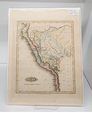
Peru
Verlag: Lucas, Fielding, London, 1824
Anbieter: Argosy Book Store, ABAA, ILAB, New York, NY, USA
Verkäuferbewertung 5 von 5 Sternen
unbound. Map. Engraving with original hand coloring. Image measures 11 1/2" x 9 1/4" Classic 19th century map of Peru, hand-colored by region. Rivers, cities, mountain ranges, and lakes are labeled. Various indigenous groups are indicated, mostly in the eastern half of the country, in the regions they inhabit. In excellent condition. Fielding Lucas Jr. was an artist, publisher and cartographer active in the early 19th century. He published his first atlas in 1815 and became known as the earliest successful commercial map publisher in Baltimore. He was also the first stationer in the United States. His son, William Lucas took over the printing and stationery business shortly after his death.
-

Cape Verd Ids
Verlag: Lucas, Fielding, London, 1824
Anbieter: Argosy Book Store, ABAA, ILAB, New York, NY, USA
Verkäuferbewertung 5 von 5 Sternen
unbound. Zustand: very good(+). Map. Engraving with original hand coloring. Image measures 8.75" x 10.5". Charming map of the Cape Verde Islands. Small tear to left edge and minor chip to bottom edge. Fielding Lucas Jr. was an artist, publisher and cartographer active in the early 19th century. He published his first atlas in 1815 and became known as the earliest successful commercial map publisher in Baltimore. He was also the first stationer in the United States. His son, William Lucas took over the printing and stationery business shortly after his death.
-

St Christophers
Verlag: Baltimore, 1823, 1823
Anbieter: Pennymead Books PBFA, Knaresborough, Vereinigtes Königreich
Verbandsmitglied: PBFA
Verkäuferbewertung 5 von 5 Sternen
EUR 217,83
EUR 17,32 Versand
Versand von Vereinigtes Königreich nach USAAnzahl: 1 verfügbar
In den WarenkorbEngraved map, 12 x 9" with wide margins. Original wash colour with later heightening. Fine.
-
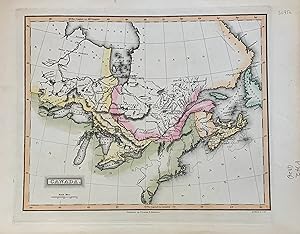
Canada
Verlag: Lucas, Fielding, Baltimore, 1824
Anbieter: Argosy Book Store, ABAA, ILAB, New York, NY, USA
Verkäuferbewertung 5 von 5 Sternen
unbound. Map. Engraving with original hand coloring. Image measures 9 x 11 inches Beautiful early map of Canada from Lake of the Woods in Manitoba to Labrador. Centered on the Great Lakes which are shown it their entirety. Includes part of Newfoundland and New England. Many tribal territories are noted. Scale in British miles. In good condition small chips to margin but not affecting image. Fielding Lucas Jr. was an artist, publisher and cartographer active in the early 19th century. He published his first atlas in 1815 and became known as the earliest successful commercial map publisher in Baltimore. He was also the first stationer in the United States. His son, William Lucas took over the printing and stationery business shortly after his death.
-

Warburg in Westphalia.
Verlag: Artist: Fielding Lucas :, 1782
Anbieter: Antique Sommer& Sapunaru KG, München, Deutschland
Verkäuferbewertung 3 von 5 Sternen

Kunst / Grafik / Poster
Technic: Copper print, colorit: original colored, condition: Perfect condition, size (in cm): 16 x 21 cm, General view of the Hanseatic town of Warburg on the river Diemel.
-

N. America
Verlag: Philadelphia, 1822
Anbieter: Argosy Book Store, ABAA, ILAB, New York, NY, USA
Verkäuferbewertung 5 von 5 Sternen
unbound. Map. Engraving with original hand coloring. Image measures 10.5" x 8.5". Rare map of North America includes Canada, United States, Mexico when most of the South West was still New Spain. Creative inset of "The Caribbee Isles". Shows cities, topographical details and waterway, with Colonial outline coloring. Full original margins with some stains along right edge. Minor spotting. Fielding Lucas Jr. was an artist, publisher and cartographer active in the early 19th century. He published his first atlas in 1815 and became known as the earliest successful commercial map published in Baltimore. He was also the first stationer in the United States. His son, William Lucas took over the printing and stationery business shortly after his death. Henry Schenck Tanner (1786-1858) was an engraver and publisher from New York City. He worked in partnership with his brother in Philadelphia for a few years before breaking off on his own. Tanner is widely considered the first native-born American publisher devoted expressly to maps. This particular map is from the rare Lucas atlas of which, apparently, only two copies are known.
-

N. America
Verlag: Philadelphia
Anbieter: Argosy Book Store, ABAA, ILAB, New York, NY, USA
Verkäuferbewertung 5 von 5 Sternen
unbound. Zustand: very good(+). Map. Engraving with original hand coloring. Image measures 10.5" x 8.5", sheet measures 13.5" x 10.75". In very good condition. Rare map of North America includes Canada, United States, Mexico when most of the South West was still New Spain. Creative inset of "The Caribbee Isles". Shows cities, topographical details and waterways. Fielding Lucas Jr. was an artist, publisher and cartographer active in the early 19th century. He published his first atlas in 1815 and became known as the earliest successful commercial map published in Baltimore. He was also the first stationer in the United States. His son, William Lucas took over the printing and stationery business shortly after his death.
-
Map of Peru
Verlag: ca. 1832, Baltimore, MD, 1832
Anbieter: Attic Books (ABAC, ILAB), London, ON, Kanada
Verkäuferbewertung 5 von 5 Sternen
Zustand: Good. 29 cm map on 38 cm page. Hand coloured later. Fielding Lucas Jr. (1781 1854) was an American cartographer, artist, and publisher prominent during the early 19th century. He is known as the earliest successful commercial map-publisher in the city of Baltimore. He often collaborated with B. T. Welch & Co.
-
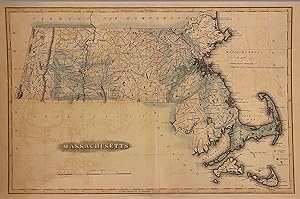
Massachusetts
Verlag: B. T. Welch & Co, Baltimore, 1824
Anbieter: Argosy Book Store, ABAA, ILAB, New York, NY, USA
Verkäuferbewertung 5 von 5 Sternen
Map. Engraving with original coloring. Image measures 11 1/2" x 17 1/4". Baltimore: 1824 Early map of Massachusetts divided by counties. Cities, towns, roads, waterways, ponds, and other topographical features are shown. Topography is depicted pictorially. In very good condition, with minor overall toning and offsetting. Some wear to margins and original centerfold. Scarce. Fielding Lucas Jr. was an artist, publisher and cartographer active in the early 19th century. He published his first atlas in 1815 and became known as the earliest successful commercial map published in Baltimore. He was also the first stationer in the United States.
-

Rhode Island
Verlag: B. T. Welch & Co, Baltimore, 1824
Anbieter: Argosy Book Store, ABAA, ILAB, New York, NY, USA
Verkäuferbewertung 5 von 5 Sternen
Map. Engraving with original coloring. Image measures 11 1/2" x 8 1/2". Baltimore: 1824 Beautifully colored early map of Rhode Island. Cities, towns, waterways, roads, bridges, and topographical features are labeled. Notably, several 'manufactories' are also labeled, including a ship yard, iron works, and mills. These sites illustrate the growing industries of the state in the early 19th century. Topography is depicted by hachure. Unusual cube, line interlocking design for the title as well as a unique compass rose design sets the map apart. Fielding Lucas Jr. was an artist, publisher and cartographer active in the early 19th century. He published his first atlas in 1815 and became known as the earliest successful commercial map published in Baltimore. He was also the first stationer in the United States.
