Cartographer (295 Ergebnisse)

A history of Cumberland and Westmorland (The Darwen county history series)
Rollinson, William Illustrator David Kirk Cartographer Hodgkiss, Alan and Treasure, Joan
- Hardcover
Anbieter: WorldofBooks, Goring-By-Sea, WS, Vereinigtes KönigreichWorldofBooks
Verkäufer/-in kontaktierenVerkäufer/-in mit 5 SternenZustand: Gebraucht - Gut
EUR 3,25
EUR 6,54 VersandVersand von Vereinigtes Königreich nach USAAnzahl: 1 verfügbar
Hardback. Zustand: Very Good. The book has been read, but is in excellent condition. Pages are intact and not marred by notes or highlighting. The spine remains undamaged.

- Softcover
Anbieter: MW Books, New York, NY, USAMW Books
Verkäufer/-in kontaktierenVerkäufer/-in mit 5 SternenZustand: Gebraucht
EUR 19,90
Versand nach gratisVersand innerhalb von USAAnzahl: 1 verfügbar
Edition Unstated. Fine map, slightly edge-bumped. Remains well-preserved overall. Physical description; 1 map : color ; 87 x 128 cm, folded to 24 x 14 cm. Notes; Scale approximately 1:2500. Based on a map first researched and produced by Col Henry Johns, 1989. Subjects; London (England). History. 16th century. Maps. London (Engl…and). Historical geography. Maps. City of London (England). Maps. Early maps. Facsimiles. 1 Kg.

Sprache: Englisch
Verlag: Southampton, United Kingdom : Ordnance Survey, 2007
- Softcover
Anbieter: MW Books, New York, NY, USAMW Books
Verkäufer/-in kontaktierenVerkäufer/-in mit 5 SternenZustand: Gebraucht
EUR 19,90
Versand nach gratisVersand innerhalb von USAAnzahl: 1 verfügbar
Revised Edition. Fine folding map. Remains well preserved overall; tight, bright, clean and sharp-cornered. Series; OS explorer map ; 410. Physical description; 1 map : colour ; 84 x 124 cm, folded to 24 x 14 cm. Notes; Previous edition: 2002. Geographic coverage Europe, Great Britain, Scotland, Inverness-shire, Skye - Portree &… Bracadale. Text in English with notes in French and German. Subjects; Skye, Island of (Scotland) ; Maps. Portree (Scotland) ; Maps. Bracadale (Scotland : Parish) ; Maps. 1:25,000. Genres; cartographic image. Map. 1 Kg.
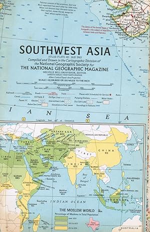
Verlag: National Geographic Society, 1963
- Softcover
- Karte
Anbieter: Bookshop Baltimore, Baltimore, MD, USABookshop Baltimore
Verkäufer/-in kontaktierenVerkäufer/-in mit 5 SternenZustand: Gebraucht - Befriedigend
EUR 9,00
EUR 5,24 VersandVersand innerhalb von USAAnzahl: 1 verfügbar
Map. Clean outer wraps with mild edge wear, fold creases. Shows India, Iran, Bay of Bengal, Saudi Arabia, Afghanistan, Ceylon, China, etc. Inset map of The Moslem World, with Percentage of Moslems in Total Population. Also includes an inset of Karachi.

Modern Istanbul Map / Modern Istanbul Haritasi: Guide to Modern Architecture in Istanbul, Turkey
Öztürk, Özlem Balci (Author)/ Media, Blue Crow (Cartographer)/ Bozkurt, Hacer (Photographer)
- Softcover
Anbieter: Revaluation Books, Exeter, Vereinigtes KönigreichRevaluation Books
Verkäufer/-in kontaktierenVerkäufer/-in mit 5 SternenZustand: Neu
EUR 12,27
EUR 11,67 VersandVersand von Vereinigtes Königreich nach USAAnzahl: 1 verfügbar
Paperback. Zustand: Brand New. fol map edition. 1 pages. 8.25x6.00x0.20 inches. In Stock.

South Asian History London Map: Guide to South Asian Historical Landmarks and Figures in London
Mohamed, Bushra (Author)/ Nathaniel, Krish (Author)/ Media, Blue Crow (Cartographer)
- Softcover
Anbieter: Revaluation Books, Exeter, Vereinigtes KönigreichRevaluation Books
Verkäufer/-in kontaktierenVerkäufer/-in mit 5 SternenZustand: Neu
EUR 12,54
EUR 11,67 VersandVersand von Vereinigtes Königreich nach USAAnzahl: 1 verfügbar
Paperback. Zustand: Brand New. fol map edition. 1 pages. 8.25x6.00x0.20 inches. In Stock.

Modern Amsterdam Map: Guide to Modern Architecture in Amsterdam, the Netherlands
Woudstra, Rixt (Author)/ Media, Blue Crow (Cartographer)/ van Duijvendijk, Loes (Photographer)
- Softcover
Anbieter: Revaluation Books, Exeter, Vereinigtes KönigreichRevaluation Books
Verkäufer/-in kontaktierenVerkäufer/-in mit 5 SternenZustand: Neu
EUR 12,54
EUR 11,67 VersandVersand von Vereinigtes Königreich nach USAAnzahl: 2 verfügbar
Paperback. Zustand: Brand New. fol map edition. 1 pages. 8.25x6.00x0.20 inches. In Stock.

Brutalist Hong Kong Map /: Guide to Brutalist Architecture in Hong Kong
Pang, Bob (Author)/ Media, Blue Crow (Cartographer)/ Mak, Kevin (Photographer)
- Softcover
Anbieter: Revaluation Books, Exeter, Vereinigtes KönigreichRevaluation Books
Verkäufer/-in kontaktierenVerkäufer/-in mit 5 SternenZustand: Neu
EUR 12,32
EUR 11,67 VersandVersand von Vereinigtes Königreich nach USAAnzahl: 2 verfügbar
Paperback. Zustand: Brand New. fol map edition. 1 pages. 8.25x6.00x0.20 inches. In Stock.

Modern Helsinki Map / Moderni Helsinki-kartta: Guide to Modern and contemporary architecture in Helsinki
Vartola, Anni (Author)/ Media, Blue Crow (Cartographer)/ Niemi, Tuukka (Photographer)
- Softcover
Anbieter: Revaluation Books, Exeter, Vereinigtes KönigreichRevaluation Books
Verkäufer/-in kontaktierenVerkäufer/-in mit 5 SternenZustand: Neu
EUR 12,58
EUR 11,67 VersandVersand von Vereinigtes Königreich nach USAAnzahl: 2 verfügbar
Paperback. Zustand: Brand New. fol map edition. 2 pages. 17.00x24.00x0.12 inches. In Stock.

- Softcover
Anbieter: Revaluation Books, Exeter, Vereinigtes KönigreichRevaluation Books
Verkäufer/-in kontaktierenVerkäufer/-in mit 5 SternenZustand: Neu
EUR 12,83
EUR 11,67 VersandVersand von Vereinigtes Königreich nach USAAnzahl: 1 verfügbar
Paperback. Zustand: Brand New. fol map edition. 1 pages. 8.25x6.00x0.20 inches. In Stock.
- Softcover
Anbieter: Revaluation Books, Exeter, Vereinigtes KönigreichRevaluation Books
Verkäufer/-in kontaktierenVerkäufer/-in mit 5 SternenZustand: Neu
EUR 13,76
EUR 11,67 VersandVersand von Vereinigtes Königreich nach USAAnzahl: 2 verfügbar
Paperback. Zustand: Brand New. 192 pages. 8.98x5.98x0.47 inches. In Stock.

- Softcover
Anbieter: Revaluation Books, Exeter, Vereinigtes KönigreichRevaluation Books
Verkäufer/-in kontaktierenVerkäufer/-in mit 5 SternenZustand: Neu
EUR 11,55
EUR 14,59 VersandVersand von Vereinigtes Königreich nach USAAnzahl: 2 verfügbar
Zustand: Brand New. 355 pages. 5.91x8.27x0.79 inches. In Stock.

The Globalisation of War: Japan Attacks, US Enters War, British Empire and Russia Holds Axis: Vol. 3
- Softcover
Anbieter: Revaluation Books, Exeter, Vereinigtes KönigreichRevaluation Books
Verkäufer/-in kontaktierenVerkäufer/-in mit 5 SternenZustand: Neu
EUR 11,55
EUR 14,59 VersandVersand von Vereinigtes Königreich nach USAAnzahl: 1 verfügbar
Zustand: Brand New. 349 pages. 5.91x8.27x0.79 inches. In Stock.

- Softcover
Anbieter: Revaluation Books, Exeter, Vereinigtes KönigreichRevaluation Books
Verkäufer/-in kontaktierenVerkäufer/-in mit 5 SternenZustand: Neu
EUR 11,55
EUR 14,59 VersandVersand von Vereinigtes Königreich nach USAAnzahl: 2 verfügbar
Zustand: Brand New. 309 pages. 5.91x8.27x0.79 inches. In Stock.

- Softcover
Anbieter: Revaluation Books, Exeter, Vereinigtes KönigreichRevaluation Books
Verkäufer/-in kontaktierenVerkäufer/-in mit 5 SternenZustand: Neu
EUR 11,55
EUR 14,59 VersandVersand von Vereinigtes Königreich nach USAAnzahl: 2 verfügbar
Zustand: Brand New. 324 pages. 5.91x8.27x0.79 inches. In Stock.
 Weitere Bilder
Sprache: Englisch
Verlag: The Manchester Education Committee for the Manchester Teachers' History Discussion Group, Manchester, 1964
- Hardcover
- Erstausgabe
Anbieter: Old Hall Bookshop, ABA ILAB PBFA BA, Brackley, Vereinigtes KönigreichOld Hall Bookshop, ABA ILAB PBFA BA
Verkäufer/-in kontaktierenVerkäufer/-in mit 5 SternenZustand: Gebraucht - Gut
EUR 9,62
EUR 17,51 VersandVersand von Vereinigtes Königreich nach USAAnzahl: 1 verfügbar
Red Cloth. Zustand: Very Good. No Dust Jacket. First Edition, Second Reprint. xvii, 322pp, illustrated with various black & white maps and drawings, some folding, pages clean and crisp, red cloth with gilt spine lettering, spine a little sunned, no dust jacket. Size: 8.75 X 5.5 Inches. L Wharfe (cartographer) (illustrator). (ill…ustrator). History of Manchester.

Rock Types of Pennsylvania (Pennsylvania Topographic and Geologic Survey Map 63).
James H. Dolimpio (Cartographer) and Pennsylvania Topographic and Geological Survey.
Verlag: Pennsylvania Topographic and Geologic Survey., 1984
- Karte
Anbieter: Eryops Books, Stephenville, TX, USAEryops Books
Verkäufer/-in kontaktierenVerkäufer/-in mit 5 SternenZustand: Gebraucht - Gut
EUR 7,16
EUR 5,24 VersandVersand innerhalb von USAAnzahl: 1 verfügbar
No Binding. Zustand: Very Good. ORIGINAL 1984 PUBLICATION; large folded map in printed envelope; ex-library; in very good condition. Map.
 Weitere Bilder
- Softcover
Anbieter: Antique Mall Books, Smyrna, GA, USAAntique Mall Books
Verkäufer/-in kontaktierenVerkäufer/-in mit 5 SternenZustand: Gebraucht - Gut
EUR 26,97
EUR 3,49 VersandVersand innerhalb von USAAnzahl: 1 verfügbar
Paperback. Zustand: Collectible: Very Good. 1st Edition Thus / 1st Paperback Printing - Naval Institute (2001). VERY GOOD, a few minor creases on cover. No marks. Binding is tight and square. xi, 241 pages : illustrations, color maps ; 30 cm. . . . . . FROM THE BACK COVER: From the Battle of Flamborough Head during the American…Revolution to the naval air wars over Vietnam and Kuwait, this historical atlas charts the course of the U.S. Navy across its entire history. Laid out here are the frigate duels of the War of 1812, the confrontation of ironclads during the Civil War, the World War II carrier battles in the Pacific, and the amphibious landings in Korea. Depicted also are campaigns, operations, and interwar interventions--like the cruise of the Susquehanna, Perry's mission to Japan, the Cuban Missile Crisis, and Desert Storm--all helping to make this cartographic portrait of U.S. naval actions understandable at a glance. The maps in this large-format, high quality book are presented in full color and show the deployment of ships, their tracks, and even some shore activity. Each map has facing text that describes the action and its political, economic, and strategic significance. The atlas is organized chronologically into ten eras with each section preceded by a thoughtful essay about that historical period and accompanied by relevant illustrations of ships, battles, and portraits of significant individuals.

Verlag: Southampton : Ordnance Survey for the Institute of Geological Sciences, 1974
- Softcover
- Erstausgabe
Anbieter: MW Books, New York, NY, USAMW Books
Verkäufer/-in kontaktierenVerkäufer/-in mit 5 SternenZustand: Gebraucht
EUR 19,90
Versand nach gratisVersand innerhalb von USAAnzahl: 1 verfügbar
First Edition. Good folding map with some slight wear and tear as with age. Remains well preserved overall; tight, bright, clean and sharp-cornered. Series; Geological survey of Great Britain (England and Wales). . 1:50,000 series. Physical description; 1 map ; 39 x 58 cm. Subjects; Geology England Stratford-upon-Avon ; Maps. Ge…ology England Evesham ; Maps. Stratford-upon-Avon (England) ; Maps. Evesham (England) ; Maps. 1:50,000. 1 Kg.
State of Louisiana. Base Map. Scale 1:500,000 (United States Geological Survey Map).
Hassan, A. F. (Cartographer) and United States Geological Survey / USGS / U.S.G.S.
Verlag: United States Geological Survey., 1948
Anbieter: Eryops Books, Stephenville, TX, USAEryops Books
Verkäufer/-in kontaktierenVerkäufer/-in mit 5 SternenZustand: Gebraucht - Gut
EUR 8,99
EUR 5,24 VersandVersand innerhalb von USAAnzahl: 1 verfügbar
No Binding. Zustand: Very Good. Large Folded Base Map; ex-corporate library; in very good condition. Map.

Verlag: National Geographic Society, 1980
- Karte
Anbieter: Bookshop Baltimore, Baltimore, MD, USABookshop Baltimore
Verkäufer/-in kontaktierenVerkäufer/-in mit 5 SternenZustand: Gebraucht - Befriedigend
EUR 9,00
EUR 5,24 VersandVersand innerhalb von USAAnzahl: 1 verfügbar
Map. Light browning and creases.
Verlag: Ballantine Books, New York, 1972
- Softcover
- Erstausgabe
Anbieter: Ground Zero Books, Ltd., Silver Spring, MD, USAGround Zero Books, Ltd.
Verkäufer/-in kontaktierenVerkäufer/-in mit 5 SternenZustand: Gebraucht - Befriedigend
EUR 15,76
EUR 4,37 VersandVersand innerhalb von USAAnzahl: 1 verfügbar
Trade paperback. Zustand: Good. First Printing [Stated]. 21 cm. 158, [2] pages. Wraps. Illustrations. Map. Some wear to covers. Introduction by Barrie Pitt. Alan Wykes was an author and journalist , Alan Wykes was a prolific storyteller with a prodigious memory for historical detail. Down the years much of his work was in collab…oration with others, a few of them better known as biographers than he was himself. In Noel Barber's final work Daughter of the Prince, published two years ago, it was Wykes who managed to finish the last two- thirds of the book on his own when Barber fell tragically ill and died suddenly. Wykes had a sharp eye while 'looking at the field' and managed to hit upon titles with such lethal subjects as The Doctor and His Enemy (1964; about syphilis) and Lucrezia Borgia (1970), Hitler (1970), Goebbels (1971), Himmler (1972) and Heydrich (1972). Under the overall editorship of Sir Basil Liddell-Hart, Barrie Pitt was responsible for the first major part-work, Purnell's History of the Second World War, a 96-instalment mass circulation series which was launched in 1966 at the Imperial War Museum. After this success he proved a generous patron of younger historians as the editor of some 100 small volumes in Ballantine's Illustrated History of World War 2 and then Ballantine's Illustrated History of the Violent Century. Himmler, the obsessive gatherer and filer of information, eventually came to wield the most real power under Hitler. As head of the Gestapo and the concentration camps, he organized the extermination of more than ten million people. It is a great educational tool for anyone interested in of the leaders in the Third Reich that planned the holocaust. Wykes does a good job of examining Himmler's personality and relating it to his professional career in the Nazi Party culminating as Reichsfuhrer SS. An accurate portrayal. Richard Natkiel (Cartographer) (illustrator).
- Softcover
Anbieter: Revaluation Books, Exeter, Vereinigtes KönigreichRevaluation Books
Verkäufer/-in kontaktierenVerkäufer/-in mit 5 SternenZustand: Neu
EUR 19,63
EUR 11,67 VersandVersand von Vereinigtes Königreich nach USAAnzahl: 1 verfügbar
Paperback. Zustand: Brand New. 192 pages. 8.98x5.98x0.47 inches. In Stock.
Verlag: Rockwell enterprises
Anbieter: Wonder Book, Frederick, MD, USAWonder Book
Verkäufer/-in kontaktierenVerkäufer/-in mit 5 SternenZustand: Gebraucht - Gut
EUR 14,63
Versand nach gratisVersand innerhalb von USAAnzahl: 1 verfügbar
Zustand: Very Good. Very Good condition. (Maps, Street maps South bay area maps) A copy that may have a few cosmetic defects. May also contain light spine creasing or a few markings such as an owner's name, short gifter's inscription or light stamp. Bundled media such as CDs, DVDs, floppy disks or access codes may not be include…d.
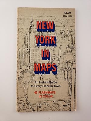
New York In Maps An Instant Guide to Every Place in Town 46 Flashmaps
Lasker, Toy, Jean George and Jean Paul Tremblay , Cartographer
Verlag: Chappaqua, NY: Flashmaps, 1969, 1969
- Softcover
Anbieter: WellRead Books, Shamong, NJ, USAWellRead Books
Verkäufer/-in kontaktierenVerkäufer/-in mit 5 SternenVerbandsmitglied: IOBA
Zustand: Gebraucht
EUR 13,51
EUR 6,99 VersandVersand innerhalb von USAAnzahl: 1 verfügbar
8vo.; glossy stiff wraps, softcover; 80 pages; color maps; lightly edgeworn else very good.

Verlag: Didot, Paris, 1747
- Karte
Anbieter: Wickham Books South, NAPLES, FL, USAWickham Books South
Verkäufer/-in kontaktierenVerkäufer/-in mit 5 SternenZustand: Gebraucht - Befriedigend
EUR 10,80
EUR 4,81 VersandVersand innerhalb von USAAnzahl: 1 verfügbar
Map. Zustand: Good. Left and right margins missing (map cut at margin lines) , very light 4" x 6" dampstain, vertical fold ; In French. Measures 14.75" x 8.25". Map of river in West Africa. Extracted from HISTOIRE GÉNÉRALE DES VOYAGES; OU, NOUVELLE COLLECTION DE TOUTES LES RELATIONS DE VOYAGES PAR MER ET PAR TERRE, Paris: Didot,… ca 1740s. ; 4to.

Cotswold Way: 5 (Sparky Walking Guides)
Sutton, Neil (Designer)/ Cox, Jon (Author)/ Burton, Peter (Author)/ Simons, Graham (Cartographer)
- Softcover
Anbieter: Revaluation Books, Exeter, Vereinigtes KönigreichRevaluation Books
Verkäufer/-in kontaktierenVerkäufer/-in mit 5 SternenZustand: Neu
EUR 19,35
EUR 14,59 VersandVersand von Vereinigtes Königreich nach USAAnzahl: 2 verfügbar
Zustand: Brand New. 96 pages. 4.84x0.39x7.32 inches. In Stock.

Verlag: Oxford University Press, 1967
- Softcover
- Erstausgabe
Anbieter: Joseph Burridge Books, Dagenham, Vereinigtes KönigreichJoseph Burridge Books
Verkäufer/-in kontaktierenVerkäufer/-in mit 5 SternenZustand: Gebraucht - Gut
EUR 6,01
EUR 16,34 VersandVersand von Vereinigtes Königreich nach USAAnzahl: 1 verfügbar
Soft cover. Zustand: Very Good. 1st Edition. 6 unnumbered pages, 105 pages : maps ; 21 cm.

Capital Ring: 3 (Sparky Walking Guides)
Cox, Jon (Author)/ Burton, Peter (Author)/ Sutton, Neil (Designer)/ Simons, Graham (Cartographer)
- Softcover
Anbieter: Revaluation Books, Exeter, Vereinigtes KönigreichRevaluation Books
Verkäufer/-in kontaktierenVerkäufer/-in mit 5 SternenZustand: Neu
EUR 22,86
EUR 11,67 VersandVersand von Vereinigtes Königreich nach USAAnzahl: 2 verfügbar
Zustand: Brand New. 192 pages. 4.84x0.39x7.32 inches. In Stock.
- Hardcover
Anbieter: Ground Zero Books, Ltd., Silver Spring, MD, USAGround Zero Books, Ltd.
Verkäufer/-in kontaktierenVerkäufer/-in mit 5 SternenZustand: Gebraucht - Befriedigend
EUR 31,51
EUR 4,37 VersandVersand innerhalb von USAAnzahl: 1 verfügbar
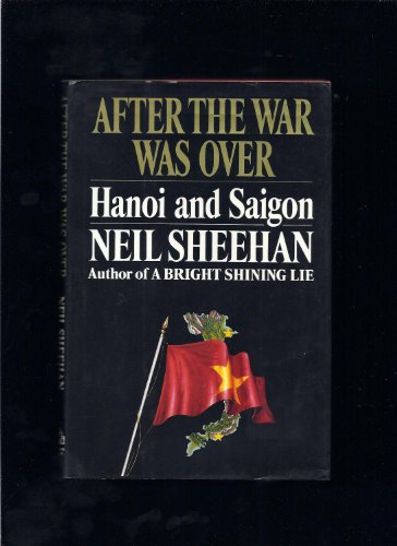
Hardcover. Zustand: Good. Zustand des Schutzumschlags: Good. Second printing [stated]. 22 cm, [8], 131, [5] pages. DJ has some wear and soiling. Staple holes in fep. Includes two page, black and white map. Cornelius Mahoney Sheehan (October 27, 1936 - January 7, 2021) was an American journalist and war correspondent. As a report…er for The New York Times in 1971, Sheehan obtained the classified Pentagon Papers from Daniel Ellsberg. His series of articles revealed a secret United States Department of Defense history of the Vietnam War and led to a US Supreme Court case, New York Times Co. v. United States, 403 U.S. 713 (1971), which invalidated the United States government's use of a restraining order to halt publication. He received a Pulitzer Prize and a National Book Award for his 1988 book A Bright Shining Lie, about the life of Lieutenant Colonel John Paul Vann and the United States involvement in the Vietnam War. Sheehan released the book, After the War Was Over: Hanoi and Saigon, in 1992. It was inspired by his visit to Vietnam three years earlier. This book recounts the author's trip back to Vietnam the year after A Bright Shining Lie was published, and the lingering effects of the war. Derived from a Kirkus review: A view of Vietnam since America's involvement, by the author of perhaps the best book on the war, A Bright Shining Lie. Here, Sheehan covers his visit to Vietnam in 1989 with his wife, Susanâ"who, with him, coauthored some of this material for a series of New Yorker articles and whom Sheehan credits here for her insight and her editing skills. Sheehan sees a Vietnam suffering not from the American war but from a prolonging of the agony by the rigid regime of Le Duan, with its prosecution of new wars and its Stalinist economics. In 1986, as General Giap relates in a longish and candid interview, came doi moi, or ``the new way.'' Out went the collective farms and heavy industrial projects; in came a free market. Within a year, Vietnam was exporting rice, and the currency had stabilized. Still, it's a desperately poor country, the North in particular, as Sheehan's tour of hospitals demonstrates: They are under equipped and cannot afford to stock antibiotics or basic vaccines. In Saigon, Sheehan is overcome with memories and seeks out his and Susan's old haunts, as well as those of John Vann, subject of much of A Bright Shining Lie. Like the North, the South is a society run by party faithfulâ"and the privileges of rank have hearkened to them, leaving out a great many of the ``mutilated.'' Even so, the armies of homeless have been eliminated, and no one is starving. In Saigon, Western influence is strongest, ready for the moment when the American embargo drops and Vietnam becomes the economic powerhouse everyone is anticipating. Already the BMWs proliferate. Essential for your Vietnam shelf. David Lindroth (Cartographer), Russell Farrell (Ja (illustrator).


