Gesamtpreis (1 Artikel Artikel):
Versandziel:

map state new york compiled (7 Ergebnisse)
Direkt zu den wichtigsten Suchergebnissen
Suchfilter
Produktart
- Alle Product Types
- Bücher (5)
- Magazine & Zeitschriften (Keine weiteren Ergebnisse entsprechen dieser Verfeinerung)
- Comics (Keine weiteren Ergebnisse entsprechen dieser Verfeinerung)
- Noten (Keine weiteren Ergebnisse entsprechen dieser Verfeinerung)
- Kunst, Grafik & Poster (Keine weiteren Ergebnisse entsprechen dieser Verfeinerung)
- Fotografien (Keine weiteren Ergebnisse entsprechen dieser Verfeinerung)
- Karten (2)
- Manuskripte & Papierantiquitäten (Keine weiteren Ergebnisse entsprechen dieser Verfeinerung)
Zustand Mehr dazu
- Neu (Keine weiteren Ergebnisse entsprechen dieser Verfeinerung)
- Wie Neu, Sehr Gut oder Gut Bis Sehr Gut (Keine weiteren Ergebnisse entsprechen dieser Verfeinerung)
- Gut oder Befriedigend (Keine weiteren Ergebnisse entsprechen dieser Verfeinerung)
- Ausreichend oder Schlecht (Keine weiteren Ergebnisse entsprechen dieser Verfeinerung)
- Wie beschrieben (7)
Einband
- alle Einbände
- Hardcover (2)
- Softcover (Keine weiteren Ergebnisse entsprechen dieser Verfeinerung)
Weitere Eigenschaften
- Erstausgabe (1)
- Signiert (Keine weiteren Ergebnisse entsprechen dieser Verfeinerung)
- Schutzumschlag (Keine weiteren Ergebnisse entsprechen dieser Verfeinerung)
- Angebotsfoto (6)
Sprache (1)
Preis
- Beliebiger Preis
- Weniger als EUR 20 (Keine weiteren Ergebnisse entsprechen dieser Verfeinerung)
- EUR 20 bis EUR 45 (Keine weiteren Ergebnisse entsprechen dieser Verfeinerung)
- Mehr als EUR 45
Gratisversand
Land des Verkäufers
Verkäuferbewertung
-
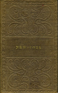
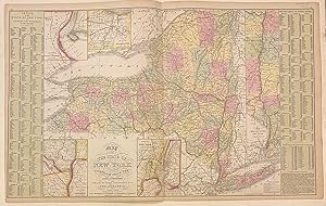
Map of the State of New York compiled from the Latest Authorities
Verlag: S. Augustus Mitchell, Philadelphia, 1838
Anbieter: Antipodean Books, Maps & Prints, ABAA, Garrison, NY, USA
Verbandsmitglied: ABAA ANZAAB ESA ILAB
Verkäuferbewertung 4 von 5 Sternen

Ephemera. Zustand: Otherwise very good condition. Folding pocket map, 17 x 21", with full period color. Bound in 16mo brown gilt & blind stamped cloth boards, stamped "New - York." on the front board. A beautiful colored copy, with county divisions and relief shown pictorially. Inset Vicinity of Rochester, Vicinity of Albany, Vicinity of New York, and Map of the Hudson River from New York to Albany. OCLC: 45669426 cites only the NY Public & NY State Library. Boards in very good condition, the map with a few corner cracks, as onion paper is prone to do.
-
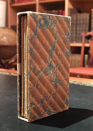
. A map of the State of New York : compiled from the latest authorities : including the turnpike roads now granted, as also the principal common roads connected therewith : intended as well for the student in geography as a directory to the Traveler
Verlag: Oxford, 1808
Anbieter: Arader Galleries - AraderNYC, New York, NY, USA
Verkäuferbewertung 5 von 5 Sternen

Single sheet, (41 x 50 cm, folded to 14 x 8 cm) includes marbled slip box (foxing, darkened, faded hand coloring, tears along the edges and folds). Early map of New York State mounted on a cloth backing depicting turnpike roads, common roads, and counties. The relief is shown pictorially, with the state borders hand colored for emphasis. The title cartouche includes the recently adopted New York State coat-of-arms, with north indicated by a stylized compass point. For more information on this map, or a warm welcome to see other maps and books of our collection at 72nd Street NYC, please contact Natalie Zadrozna.
-

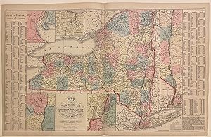
Map of the State of New York Compiled from the Latest Authorities
Verlag: Charles Desilver, Philadelphia, 1856
Anbieter: Main Street Fine Books & Mss, ABAA, Galena, IL, USA
Verbandsmitglied: ABAA ILAB MWABA
Verkäuferbewertung 5 von 5 Sternen
Karte
27" X 17˝" (image 26" X 16"). Hand colored. inset counties and townships population table. Very good. Minor discoloration along bottom edge (not touching image); 2" separation at bottom of center fold (archivally repaired on verso).
-
Map of the State of New York compiled from the latest authorities
Verlag: Desilver, Charles, Philadelphia, 1857
Anbieter: Argosy Book Store, ABAA, ILAB, New York, NY, USA
Verkäuferbewertung 5 von 5 Sternen
unbound. Map. Engraving with original hand coloring. Image measures 16" x 26 1/8" Nice clear map of New York divided into counties. Shows towns, major routes, railroads, waterways, and topographical features. Insets include the vicinities of Albany, New York City, Rochester, and Niagara Falls, and a Map of the Hudson River from New York to Albany. On either side of the map is a table listing populations of counties and townships, square miles of counties, and other miscellaneous statistics. From the "New Universal Atlas". Plate was originally published by Samuel Augustus Mitchell, who sold the copyright to Thomas, Cowperthwait & Company in 1850, which was in turn bought by Charles Desilver in 1856. Charles Desilver (fl. 1856-1862) was a Philadelphia based map publisher active in the mid 19th century. He purchased the copyright for Mitchell's 'New Universal Atlas', publishing his own editions in 1856 and 1857. The maps from these editions were updated with the most recent information, especially related to roads, canals, and railways.
-
Map of the State of New York compiled from the latest authorities
Verlag: Desilver, Charles, Philadelphia, 1855
Anbieter: Argosy Book Store, ABAA, ILAB, New York, NY, USA
Verkäuferbewertung 5 von 5 Sternen
unbound. Map. Engraving with original hand coloring. Image measures 16 1/8" x 26 1/4" Fascinating map of New York divided into counties. Shows towns, major routes, railroads, waterways, and topographical features. Insets include the vicinities of Albany, New York City, Rochester, and Niagara Falls, and a Map of the Hudson River from New York to Albany. On either side of the map is a table listing populations of counties and townships, square miles of counties, and other miscellaneous statistics. From the "New Universal Atlas". Plate was originally published by Samuel Augustus Mitchell, who sold the copyright to Thomas, Cowperthwait & Company in 1850, which was in turn bought by Charles Desilver in 1856. Thomas, Cowperthwait & Co. took over publication of S. A. Mitchell's important "Universal Atlas" in 1850, and continued to produce updated maps that were considered some of the best commercial cartography of the 19th century.
-
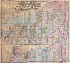
The National Publishing Company's New Railroad, Post-Office, Township and County Map of New York with Distances Between Stations.; Compiled from the Latest Government and State Surveys and Original Sources
Verlag: The National Publishing Company, Boston, 1902
Anbieter: Argosy Book Store, ABAA, ILAB, New York, NY, USA
Verkäuferbewertung 5 von 5 Sternen
Case map. Color lithograph. Paper map mounted to linen. 40.5" x 46.25". Stains on verso, some bleed through to image side.
-
Map of the city of Brooklyn, as laid out by commissioners, and confirmed by acts of the Legislature of the state of New York, made from actual surveys the farm lines and names of original owners being accurately drawn from authentic sources. Containing also a map of the Village of Williamsburgh, and part of the city of New-York: compiled from accurate surveys and documents and showing the true relative position of all.
Erscheinungsdatum: 1852
Anbieter: Geographicus Rare Antique Maps, Brooklyn, NY, USA
Verbandsmitglied: ABAA ESA ILAB
Verkäuferbewertung 3 von 5 Sternen

Karte Erstausgabe
Very good. Steel plate printing on onion-skin paper. Wear and toning along some old fold lines. Archival verso reinforcement at most fold intersections - a few minor points of infill at the same. Accompanies original binder. Size 36 x 48 Inches. This is J. H. Colton's impressive large-scale 1852 map of Brooklyn and Williamsburg. In its 1839 first edition, it is the Brooklyn equivalent to both the 1811 Commissioner' Plan and Colton's great 1836 map of Manhattan, and as such can reasonably be considered the most important and best map of Brooklyn to appear in the 19th century. The present map, 1852, is, in so far as we can tell, the third edition, retaining much of the significance of the first, while also featuring fascinating updates illustrating the break-neck pace with which Brooklyn was then urbanizing. Creating Brooklyn This map was first issued in the wake of a February 28, 1839 New York State legislative act validating the work of Brooklyn Street Commissioners John S. Stoddard (surveyor and engineer), Alonzo. G. Hammond (commissioner), Samuel Cheever (commissioner), and Isaiah Tiffany (commissioner). These individuals were appointed four years earlier, in 1835, and dedicated the intervening years to completing a comprehensive plan for expanding urbanized Brooklyn by breaking up old estates and farms into streets, avenues, and property lots. The Act passed in 1839 confirmed their work as the official map of Brooklyn - this map by Colton closely followed, representing the earliest published official map of Brooklyn. In the first edition, Stoddard, Hammond, Cheever, and Tiffany are named. In subsequent editions, as here, they are named simply as 'the Commissioners'. It is likely that their names were removed due to criticism that made their names unpopular. A Bit of Controversy The publication of this map in 1839 was the cause of considerable controversy. Hammond, who drew the map, initially submitted the copyright on his own behalf, before transferring it to Colton. It was argued that by doing so he violated the rights of the city of Brooklyn. He defended himself in the Long Island Star , While the laying out of the city was in progress, very many highly respectable citizens were in the frequent habit of calling upon Mr. Hammond at his office, and enquiring how they could obtain a map when the work was completed, and if one would be published? Under these influences Messrs Hammond and Stoddard entered into an arrangement by which the former was to secure the copy right for their mutual benefit, and the latter was to furnish a manuscript, and to unite their exertions to procure the publication of such a map In doing this no pecuniary motive had influence and feared they might sustain a loss [believing] that none but a map publisher could safely publish with the prospect of covering expenses they transferred all benefits of the copy right to Mr. Colton of New York, a justly celebrated publisher The city of Brooklyn, as such, could never publish a map for the use of the citizens without expenditure far above their receipts. ('Long Island Star', March 14, 1839) A Closer Look Oriented to the southeast, coverage embraces only a small part of modern-day Brooklyn, including Downtown Brooklyn, Brooklyn Heights, Williamsburg, Bedford-Stuyvesant, Red Hook, Gowanus, Park Slope, Greenwood Cemetery, the Navy Yard, and Sunset Park. Southern Manhattan and Governors islands appear at the base of the map. Concentric circles in quarter-mile increments illustrate distances from the Battery, underscoring Brooklyn's deep and long-standing connection to Manhattan - even though at the time they remained separate cities. The map also meticulously notes swamp lands and drainage areas of natural ponds and rivers, including some that remain (if much changed) like Gowanus Creek and Bushwick Inlet, and others, like Freek and Denton's mill ponds, which have long been drained. Brooklyn Farm Lines Like Manhattan during his same period.