Gesamtpreis (1 Artikel Artikel):
Versandziel:

desilver charles (17 Ergebnisse)
Direkt zu den wichtigsten Suchergebnissen
Suchfilter
Produktart
- Alle Product Types
- Bücher (17)
- Magazine & Zeitschriften (Keine weiteren Ergebnisse entsprechen dieser Verfeinerung)
- Comics (Keine weiteren Ergebnisse entsprechen dieser Verfeinerung)
- Noten (Keine weiteren Ergebnisse entsprechen dieser Verfeinerung)
- Kunst, Grafik & Poster (Keine weiteren Ergebnisse entsprechen dieser Verfeinerung)
- Fotografien (Keine weiteren Ergebnisse entsprechen dieser Verfeinerung)
- Karten (Keine weiteren Ergebnisse entsprechen dieser Verfeinerung)
- Manuskripte & Papierantiquitäten (Keine weiteren Ergebnisse entsprechen dieser Verfeinerung)
Zustand Mehr dazu
- Neu (1)
- Wie Neu, Sehr Gut oder Gut Bis Sehr Gut (Keine weiteren Ergebnisse entsprechen dieser Verfeinerung)
- Gut oder Befriedigend (3)
- Ausreichend oder Schlecht (Keine weiteren Ergebnisse entsprechen dieser Verfeinerung)
- Wie beschrieben (13)
Einband
- alle Einbände
- Hardcover (Keine weiteren Ergebnisse entsprechen dieser Verfeinerung)
- Softcover (1)
Weitere Eigenschaften
- Erstausgabe (Keine weiteren Ergebnisse entsprechen dieser Verfeinerung)
- Signiert (Keine weiteren Ergebnisse entsprechen dieser Verfeinerung)
- Schutzumschlag (Keine weiteren Ergebnisse entsprechen dieser Verfeinerung)
- Angebotsfoto (15)
Sprache (2)
Preis
- Beliebiger Preis
- Weniger als EUR 20 (Keine weiteren Ergebnisse entsprechen dieser Verfeinerung)
- EUR 20 bis EUR 45 (Keine weiteren Ergebnisse entsprechen dieser Verfeinerung)
- Mehr als EUR 45
Gratisversand
- Kostenloser Versand nach USA (Keine weiteren Ergebnisse entsprechen dieser Verfeinerung)
Land des Verkäufers
Verkäuferbewertung
-

Pictorial History of Mexico and the Mexican War
Anbieter: Ria Christie Collections, Uxbridge, Vereinigtes Königreich
Verkäuferbewertung 5 von 5 Sternen

EUR 55,13
EUR 13,98 Versand
Versand von Vereinigtes Königreich nach USAAnzahl: Mehr als 20 verfügbar
In den WarenkorbZustand: New. In.
-
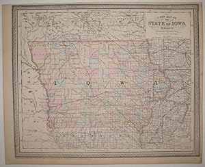
A New Map of the State of Iowa
Verlag: Desilver, Charles, Philadelphia, 1856
Anbieter: Argosy Book Store, ABAA, ILAB, New York, NY, USA
Verkäuferbewertung 5 von 5 Sternen
unbound. Zustand: very good(+). Map. Engraving with original hand coloring. Image measures 13" x 16". Nice clear map of Iowa divided into counties. Showing towns, major routes, railroads and waterways. From the "New Universal Atlas". Plate was originally published by Samuel Augustus Mitchell, who sold the copyright to Thomas, Cowperthwait & Company in 1850, which was in turn bought by Charles Desilver in 1856. Top margin slightly cropped, light scattered staining.
-

Canada West Formerly Upper Canada
Verlag: Cowperthwait, Philadelphia, 1857
Anbieter: Argosy Book Store, ABAA, ILAB, New York, NY, USA
Verkäuferbewertung 5 von 5 Sternen
unbound. Map. Lithograph with original hand coloring. Image measures 14" x 17". This lovely 1857 map of Ontario, Canada depicts the province in its entirety. The map includes part of New York State as well. "Canada West," previously known as "Upper Canada" is color coded at the district level and notes railroads, cities, rivers, mountains, and other important topographic elements. Mississauga First Nation territory is noted. An inset in the lower right features Vicinity of the Falls of Niagara as well as an inset of the City of Toronto and it's Environs The map is in good condition. Charles Desilver (fl. 1856-1862) was a Philadelphia based map publisher active in the mid 19th century. He purchased the copyright for Mitchell's 'New Universal Atlas', publishing his own editions in 1856 and 1857. The maps from these editions were updated with the most recent information, especially related to roads, canals, and railways.
-
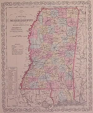
A New Map of Mississippi with its Roads & Distances
Verlag: Thomas, Cowperthwait & Co, Philadelphia, 1857
Anbieter: Argosy Book Store, ABAA, ILAB, New York, NY, USA
Verkäuferbewertung 5 von 5 Sternen
unbound. Zustand: very good(+). Map. Engraving with original hand coloring. Image measures 14" x 11.5". Nice clean map of Mississippi divided into counties. Shows major cities, major routes, waterways and railroads. Includes table of steam boat routes. From the "New Universal Atlas". In excellent condition. Plate was originally published by Samuel Augustus Mitchell, who sold the copyright to Thomas, Cowperthwait & Company in 1850, which was in turn bought by Charles Desilver in 1856.
-
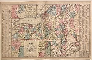
Map of the State of New York compiled from the latest authorities
Verlag: Desilver, Charles, Philadelphia, 1857
Anbieter: Argosy Book Store, ABAA, ILAB, New York, NY, USA
Verkäuferbewertung 5 von 5 Sternen
unbound. Map. Engraving with original hand coloring. Image measures 16" x 26 1/8" Nice clear map of New York divided into counties. Shows towns, major routes, railroads, waterways, and topographical features. Insets include the vicinities of Albany, New York City, Rochester, and Niagara Falls, and a Map of the Hudson River from New York to Albany. On either side of the map is a table listing populations of counties and townships, square miles of counties, and other miscellaneous statistics. From the "New Universal Atlas". Plate was originally published by Samuel Augustus Mitchell, who sold the copyright to Thomas, Cowperthwait & Company in 1850, which was in turn bought by Charles Desilver in 1856. Charles Desilver (fl. 1856-1862) was a Philadelphia based map publisher active in the mid 19th century. He purchased the copyright for Mitchell's 'New Universal Atlas', publishing his own editions in 1856 and 1857. The maps from these editions were updated with the most recent information, especially related to roads, canals, and railways.
-

A New Map of Maine
Verlag: Charles Desilver, Philadelphia, 1856
Anbieter: Argosy Book Store, ABAA, ILAB, New York, NY, USA
Verkäuferbewertung 5 von 5 Sternen
unbound. Map. Engraving with original hand coloring. Image measures 15 1/4" x 12". Classic 19th century map of Maine divided into counties, showing towns, major routes, waterways and railroads. Includes a table in the upper left corner showing counties and their populations in 1840 and 1850, as well as population growth of the state from 1765 to 1850. This map was published in Desilver's 1856 edition of the "New Universal Atlas". In excellent condition. Charles Desilver (fl. 1856-1862) was a Philadelphia based map publisher active in the mid 19th century. He purchased the copyright for Mitchell's "New Universal Atlas", publishing his own editions in 1856 and 1857. The maps from these editions were updated with the most recent information, especially related to roads, canals, and railways.
-

A New Map of Louisiana
Verlag: Charles Desilver, Philadelphia, 1858
Anbieter: Argosy Book Store, ABAA, ILAB, New York, NY, USA
Verkäuferbewertung 5 von 5 Sternen
unbound. J. L. Hazzard (illustrator). Map. Engraving with original hand coloring. Image measures 14 3/4" x 11 3/4" Lovely map of Louisiana divided into counties. Shows major cities, major routes, waterways and railroads. Includes inset showing New Orleans. A table in the upper left indicates steam boat routes from New Orleans to Pittsburgh, to Natchitoches, and to Balize. Chips and tonign to margins. This map was published in Desilver's 1856 edition of the "New Universal Atlas". In excellent condition. Charles Desilver (fl. 1856-1862) was a Philadelphia based map publisher active in the mid 19th century. He purchased the copyright for Mitchell's "New Universal Atlas", publishing his own editions in 1856 and 1857. The maps from these editions were updated with the most recent information, especially related to roads, canals, and railways.
-
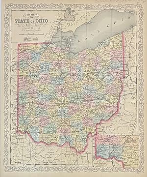
A New Map of the State of Ohio
Verlag: Desilver, Charles, Philadelphia, 1856
Anbieter: Argosy Book Store, ABAA, ILAB, New York, NY, USA
Verkäuferbewertung 5 von 5 Sternen
unbound. Map. Engraving with original hand coloring. Image measures 16" x 13" Classic map of Ohio divided into counties. Showing towns, major routes, railroads and waterways. Includes an inset view showing the Vicinity of Cincinnati. In excellent condition. Charles Desilver (fl. 1856-1862) was a Philadelphia based map publisher active in the mid 19th century. He purchased the copyright for Mitchell's "New Universal Atlas", publishing his own editions in 1856 and 1857. The maps from these editions were updated with the most recent information, especially related to roads, canals, and railways.
-
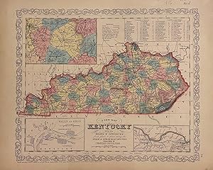
A New Map of Kentucky with its Roads & Distances
Verlag: Charles Desilver, Philadelphia, 1856
Anbieter: Argosy Book Store, ABAA, ILAB, New York, NY, USA
Verkäuferbewertung 5 von 5 Sternen
unbound. Map. Engraving with original hand coloring. Image measures 14" x 11.5". Nice clean map of Kentucky divided into counties. Shows major cities, major routes, waterways and railroads. Includes table of steam boat routes. Includes insets showing larger scale depictions of roads surrounding Lexington, and along the Ohio River near Clarksburg, and at the Falls of Ohio near Louisville. A table in the upper right corner indicates steam boat routes from Louisville to Pittsburgh, and from Louisville to New Orleans. From the "New Universal Atlas". In very good condition with minor wear to margins, not affecting the image. Plate was originally published by Samuel Augustus Mitchell, who sold the copyright to Thomas, Cowperthwait & Company in 1850, which was in turn bought by Charles Desilver in 1856.
-

Greece
Verlag: H. N. Burroughs, Philadelphia, 1856
Anbieter: Argosy Book Store, ABAA, ILAB, New York, NY, USA
Verkäuferbewertung 5 von 5 Sternen
unbound. Henry Tanner (illustrator). Map. Lithograph with original hand coloring. Philadelphia: H.N. Burroughs, 1846. Image measures 12" x 15" Detailed map of the Grecian Archipelago. An inset in the lower left corner depicts the island of Candia (Crete). The map is labeled with towns, rivers, and islands. In very good condition, with uneven borders. Samuel Augustus Mitchell Sr. (1792-1868) published this map as part of the first edition of his seminal New Universal Atlas. Mitchell is one of the pioneers in American cartography of the 19th century and led the conversion of engraved map plates to more affordable lithographic plates. Charles Desilver (fl. 1856-1862) was a Philadelphia based map publisher active in the mid 19th century. He purchased the copyright for Mitchell's 'New Universal Atlas', publishing his own editions in 1856 and 1857. The maps from these editions were updated with the most recent information, especially related to roads, canals, and railways.
-

Mexico & Guatemala
Verlag: Charles Desilver, Philadelphia, 1856
Anbieter: Argosy Book Store, ABAA, ILAB, New York, NY, USA
Verkäuferbewertung 5 von 5 Sternen
unbound. Map. Engraving with original hand coloring. Image measures 12.25" x 15". This classic map of Mexico was published shortly after the end of the Mexican-American War. It features an inset of the Valley of Mexico at lower left, and three insets along the top show maps of "Guatemala or Central America", "the Isthmus of Tehuantepec showing the proposed route from the Gulf of Mexico to the Pacific Ocean (the proposed trans-continental canal was never built)", and "the Isthmus or Nicaragua showing the proposed routes from The Caribbean Sea to the Pacific Ocean". Several cities, towns, canals, and topographic details are noted throughout the map. Both proposed and realized trade routes are noted. From the "New Universal Atlas". The plate was originally published by Samuel Augustus Mitchell, who sold the copyright to Thomas, Cowperthwait & Company in 1850, which was in turn bought by Charles Desilver in 1856. The map is in good condition with minor foxing. Charles Desilver (fl. 1856-1862) was a Philadelphia based map publisher active in the mid 19th century. He purchased the copyright for Mitchell's New Universal Atlas, publishing his own editions in 1856 and 1857. The maps from these editions were updated with the most recent information, especially related to roads, canals, and railways.
-
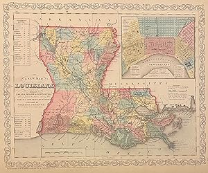
A New Map of Louisiana with its Canals, Roads, & Distances
Verlag: Charles Desilver, Philadelphia, 1856
Anbieter: Argosy Book Store, ABAA, ILAB, New York, NY, USA
Verkäuferbewertung 5 von 5 Sternen
unbound. Map. Engraving with original hand coloring. Image measures 14 3/4" x 11 3/4" Lovely map of Louisiana divided into counties. Shows major cities, major routes, waterways and railroads. Includes inset showing New Orleans. A table in the upper left indicates steam boat routes from New Orleans to Pittsburgh, to Natchitoches, and to Balize. This map was published in Desilver's 1856 edition of the "New Universal Atlas". In excellent condition. Charles Desilver (fl. 1856-1862) was a Philadelphia based map publisher active in the mid 19th century. He purchased the copyright for Mitchell%u2019s %u201CNew Universal Atlas%u201D, publishing his own editions in 1856 and 1857. The maps from these editions were updated with the most recent information, especially related to roads, canals, and railways.
-

A New Map of Tennessee with its Roads & Distances
Verlag: Charles Desilver, Philadelphia, 1856
Anbieter: Argosy Book Store, ABAA, ILAB, New York, NY, USA
Verkäuferbewertung 5 von 5 Sternen
unbound. Map. Engraving with original hand coloring. Image measures 11 1/2" x 15 3/8" Nice clean map of Tennessee divided into counties. Shows major cities, major routes, waterways and railroads. Includes table of steam boat routes. Includes two insets showing "Environs of Nashville" and "Environs of Knoxville". From the "New Universal Atlas". In excellent condition. Plate was originally published by Samuel Augustus Mitchell, who sold the copyright to Thomas, Cowperthwait & Company in 1850, which was in turn bought by Charles Desilver in 1856. Charles Desilver (fl. 1856-1862) was a Philadelphia based map publisher active in the mid 19th century. He purchased the copyright for Mitchell%u2019s %u201CNew Universal Atlas%u201D, publishing his own editions in 1856 and 1857. The maps from these editions were updated with the most recent information, especially related to roads, canals, and railways.
-

City of Washington
Verlag: Charles Desilver, Philadelphia, 1856
Anbieter: Argosy Book Store, ABAA, ILAB, New York, NY, USA
Verkäuferbewertung 5 von 5 Sternen
unbound. Map. Engraving with original hand coloring. Image measures 12 x 15" Classic 19th century map of Washington D. C. divided into hand colored wards, showing towns, major routes, waterways, railroads and bridges. Includes a table in the lower left with wards and sites listed. This map was published in Desilver's 1856 edition of the "New Universal Atlas". In very good condition. Charles Desilver (fl. 1856-1862) was a Philadelphia based map publisher active in the mid 19th century. He purchased the copyright for Mitchell's "New Universal Atlas", publishing his own editions in 1856 and 1857. The maps from these editions were updated with the most recent information, especially related to roads, canals, and railways.
-
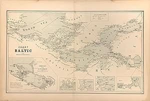
Chart of the Baltic from Admiralty & Russian Surveys
Verlag: William Boell, New York, 1857
Anbieter: Argosy Book Store, ABAA, ILAB, New York, NY, USA
Verkäuferbewertung 5 von 5 Sternen
unbound. Map. Color lithograph. Image measures 11.75" x 14.25". This scarce chart of the Baltic Sea is exceptional for its precise rendering of the coastlines between Scandinavia and the coast of Western Europe. The waters of the central Baltic Sea extend outward into the Gulfs of Bothnia and Finland in the west and the North Sea in the East. Along the coasts, towns, forts, and lighthouses are labeled and establish a level of detail that carries over into the five insets along the bottom of the map. The largest, showing Coronstadt and St. Petersburg, includes multiple useful tips for navigators that identify dangerous conditions. The other four Sveaborg, Port Baltic, Reval, and Riga highlight some of the bustling ports in this significant region of European waterways. The map is in very good condition with full margins as issued. Light staining around edges not affecting the image. Map is bright and clean except for some slight discoloration along the center fold. It first appeared in Charles Desilver's edition of S.A. Mitchell's "New Universal Atlas" as published in 1856. This edition was published in New York by Boell.
-

A New Map of Florida
Verlag: Philadelphia, 1856
Anbieter: William Chrisant & Sons, ABAA, ILAB. IOBA, ABA, Ephemera Society, Fort Lauderdale, FL, USA
Verbandsmitglied: ABAA ESA ILAB
Verkäuferbewertung 5 von 5 Sternen
Zustand: Very Good. Scarce contemporary hand colored map of Florida from the 1856 edition of Desilver's A New Universal Atlas. In comparison to Desilver's earlier maps of Florida, a decorative border is present here with a smaller Gulf of Mexico. The map measures approximately 12 x 14.5 in (30.5 x 37 cm); paper size is 14 x 17 in (35.5 x 43 cm). Minor foxing predominantly affecting verso (see image). Small tape repair to right edge.
-
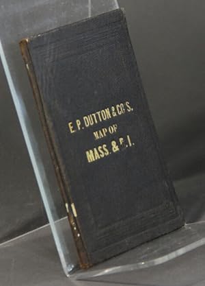
Map of Massachusetts and Rhode Island
Verlag: Charles Desilver, Philadelphia, 1859
Anbieter: Rulon-Miller Books (ABAA / ILAB), St. Paul, MN, USA
Verbandsmitglied: ABAA ILAB RMABA
Verkäuferbewertung 5 von 5 Sternen
Hand-colored folding pocket map approx. 13Ľ" x 16˝" showing the two states, with an inset of Boston and a population statistical table. Very good, no breaks at the folds. Boston Public, AAS, and Harvard only in OCLC.