Gesamtpreis (1 Artikel Artikel):
Versandziel:

russian empire (13 Ergebnisse)
Direkt zu den wichtigsten Suchergebnissen
Suchfilter
Produktart
- Alle Product Types
- Bücher (7)
- Magazine & Zeitschriften (Keine weiteren Ergebnisse entsprechen dieser Verfeinerung)
- Comics (Keine weiteren Ergebnisse entsprechen dieser Verfeinerung)
- Noten (Keine weiteren Ergebnisse entsprechen dieser Verfeinerung)
- Kunst, Grafik & Poster (Keine weiteren Ergebnisse entsprechen dieser Verfeinerung)
- Fotografien (Keine weiteren Ergebnisse entsprechen dieser Verfeinerung)
- Karten (6)
- Manuskripte & Papierantiquitäten (Keine weiteren Ergebnisse entsprechen dieser Verfeinerung)
Zustand Mehr dazu
- Neu (Keine weiteren Ergebnisse entsprechen dieser Verfeinerung)
- Wie Neu, Sehr Gut oder Gut Bis Sehr Gut (Keine weiteren Ergebnisse entsprechen dieser Verfeinerung)
- Gut oder Befriedigend (5)
- Ausreichend oder Schlecht (Keine weiteren Ergebnisse entsprechen dieser Verfeinerung)
- Wie beschrieben (8)
Einband
- alle Einbände
- Hardcover (1)
- Softcover (Keine weiteren Ergebnisse entsprechen dieser Verfeinerung)
Weitere Eigenschaften
Sprache (2)
Preis
- Beliebiger Preis
- Weniger als EUR 20 (Keine weiteren Ergebnisse entsprechen dieser Verfeinerung)
- EUR 20 bis EUR 45
- Mehr als EUR 45
Gratisversand
- Kostenloser Versand nach USA (Keine weiteren Ergebnisse entsprechen dieser Verfeinerung)
Land des Verkäufers
Verkäuferbewertung
-

Russia and the Russian Empire Map Antique Map
Sprache: Englisch
Erscheinungsdatum: 1840
Anbieter: K Books Ltd ABA ILAB, York, YORKS, Vereinigtes Königreich
Verbandsmitglied: ABA ILAB PBFA
Verkäuferbewertung 5 von 5 Sternen

EUR 41,34
EUR 22,36 Versand
Versand von Vereinigtes Königreich nach USAAnzahl: 1 verfügbar
In den WarenkorbNo Binding. Zustand: Very Good. Antique map . Hand coloured, engraved map. mounted - matted - and ready to frame .12 x 10 inches. a vg copy of an attractive decorative hand coloured antique map. . A splendid map, colouring not contemporary but delicately and expertly done - a fine map of Russia and the Russian Empire.
-
Siberia and the Exile System in Two Volumes | Volume One (1 | I) and Volume Two (2 | II) (Two Volumes Complete)
Verlag: Published by James R. Osgood McIlvaine & Co. 45 Albemarle Street, London First UK Edition . 1891., 1891
Anbieter: Little Stour Books PBFA Member, Canterbury, Vereinigtes Königreich
Verbandsmitglied: PBFA
Verkäuferbewertung 5 von 5 Sternen
Erstausgabe
EUR 236,21
EUR 34,40 Versand
Versand von Vereinigtes Königreich nach USAAnzahl: 1 verfügbar
In den WarenkorbFirst British edition from US sheets. Uniform matching hard back binding in publisher's original camel brown cloth covered boards, faded blocked and lettered gilt backs, olivine top edges. 8vo. 9Ľ'' x 6Ľ''. In May 1885, Kennan began this voyage across Siberia. He had been very publicly positive about the Tsarist Russian government and its policies and his journey was approved by the Russian government. However, in the course of his meetings with exiled dissidents during his travel, notably Nikolai Mikhailovich Yadrintsev, he changed his mind about the Russian imperial system. On his return to the United States in August 1886, he became an ardent critic of the Russian autocracy and began to espouse the cause of Russian democracy. Kennan devoted much of the next twenty years to promoting the cause of a Russian revolution, mainly by lecturing. Contents | Volume 1: frontispiece, (xv)-blank, 409 pp with 4 maps and 90 illustrations | Volume 2: frontispiece, (x)-blank, 575 pp with 3 maps and 104 illustrations. In Very Good condition. Heavy volume pair weighing 3 kg, extra postage will be requested over and above our default setting for destinations outside of the United Kingdom. Member of the P.B.F.A. SIBERIA (Sibir, Siberian).
-
MAP OF RUSSIAN EMPIRE - Original Antique Map, Printed c 1785
Sprache: Englisch
Erscheinungsdatum: 1785
Anbieter: K Books Ltd ABA ILAB, York, YORKS, Vereinigtes Königreich
Verbandsmitglied: ABA ILAB PBFA
Verkäuferbewertung 5 von 5 Sternen
EUR 106,29
EUR 22,36 Versand
Versand von Vereinigtes Königreich nach USAAnzahl: 1 verfügbar
In den WarenkorbNo Binding. Zustand: Very Good. Original antique map, engraved for Millar's New Complete & Universal System of Geography. Colouring not contemporary, but delicately and expertly done. Mounted (matted) and ready to frame. Cartouche. No date of publication. Extends from Sweden in the West to include Japan in the East.
-
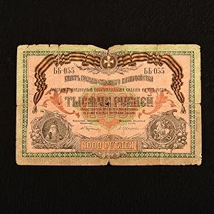
1000 Rubles Russian Banknote
Verlag: None, Russian Empire, 1919
Anbieter: Rooke Books PBFA, Bath, Vereinigtes Königreich
Verbandsmitglied: PBFA
Verkäuferbewertung 5 von 5 Sternen
EUR 88,58
EUR 22,92 Versand
Versand von Vereinigtes Königreich nach USAAnzahl: 1 verfügbar
In den WarenkorbLoose Pages, Articles. Zustand: Good. None (illustrator). A fascinating collectible 1919 banknote, from a monumental period in Russian history. A 1000 ruble banknote, issued in 1919 by the General Command of the Armed Forces of South Russia. This was an administrative body in southern Russia controlled by the Russian White movement's armed forces. The White Movement was a confederation of anti-communist forces that fought the communist Bolsheviks during the Russian Civil War (1917-1923). The 1000 note was added in 1917. Between 1917 and 1922 there was a transition from Imperial rubles to Soviet rubles. A scarce collectible item from a monumental period in Russian history. Smart condition. Some chipping to the edges. Two small punctures to the centre. Colour is faded, but text remains clear. Closed tear of about half an inch to the left edge. Closed tear of about 2 inches to the right edge. Some creasing overall. Good. book.
-
![Bild des Verkäufers für Oswietlenie w fotografii [Lighting in Photography 1963, 1970, 1972 the updated version was published under the title 'Light and Shadow in Photography in 2006, 2008 and 2017] Polish Edition zum Verkauf von Little Stour Books PBFA Member](https://pictures.abebooks.com/inventory/md/md22841915408.jpg)
Oswietlenie w fotografii [Lighting in Photography 1963, 1970, 1972 the updated version was published under the title 'Light and Shadow in Photography in 2006, 2008 and 2017] Polish Edition
Verlag: Published by Wydawnictwa Artystyczne I Filmowe, Warsaw First Edition . 1969., 1969
Anbieter: Little Stour Books PBFA Member, Canterbury, Vereinigtes Königreich
Verbandsmitglied: PBFA
Verkäuferbewertung 5 von 5 Sternen
Erstausgabe
EUR 230,30
EUR 34,40 Versand
Versand von Vereinigtes Königreich nach USAAnzahl: 1 verfügbar
In den WarenkorbFirst edition in publisher's original black and white illustrated card wrap covers (soft back). 8vo. 8'' x 5˝''. Contains 190 printed pages of Polish text with monochrome illustrations, figures and photographs throughout. Very Good condition book in Very Good condition dust wrapper with light rubbing to the edges. Errata slip and Warsaw University Zaswiadczenie (certificate) loosely inserted. Dust wrapper supplied in archive acetate film protection, it does not adhere to the book or to the dust wrapper. Member of the P.B.F.A. POLAND & POLISH HISTORY.
-
![Bild des Verkäufers für ???????????????. [Fukushima ch?sa banri no ensei tanki ryok? no zu]. [Illustrations of Lieutenant Colonel Fukushima's Single Expedition across Ten Thousand Miles]. zum Verkauf von Asia Bookroom ANZAAB/ILAB](https://pictures.abebooks.com/inventory/md/md31876295986.jpg)
???????????????. [Fukushima ch?sa banri no ensei tanki ryok? no zu]. [Illustrations of Lieutenant Colonel Fukushima's Single Expedition across Ten Thousand Miles].
Verlag: ?????. [Fukui Einosuke]. Meiji 26 [1893]., ??. [Osaka]., 1893
Anbieter: Asia Bookroom ANZAAB/ILAB, Canberra, ACT, Australien
Verkäuferbewertung 5 von 5 Sternen
Handcoloured folding engraving, 37.5 x 51cm. A prior owner's name is recorded in brush strokes down the left margin. Few small washi repaired tears, two old repaired tears on the reverse, some occasional browning particularly at centre fold, light staining upper margin intruding a little into the printed image. Overall an attractive copy. Scarce. Lieutenant Colonel Fukushima Yasumasa (1852 ? 1919) undertook a remarkable solo horseback expedition across Eurasia in 1892. Starting in Poland, he traversed Russia and Siberia on his journey. Stationed in Berlin as a military attaché in 1887, he was tasked with researching the Trans-Siberian Railway under construction by Russia. His successful expedition was followed by further explorations in India and the Balkan Peninsula.This sheet, divided into 24 illustrated panels, narrates Fukushima's story, from his youth to his triumphant return after the expedition. Filled with adventure, the story depicts his encounters with both danger and excitement. The narrative unfolds in a clockwise direction, starting from the bottom right corner, similar to a sugoroku game, which this may be but it is uncertain. The central panel, featuring a newly erected statue, represents the final goal of his journey. Each panel is accompanied by a caption that furthers the story.
-
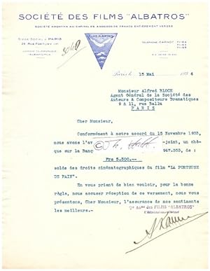
ALEXANDRE KAMENKA (1888-1969) ukrainisch-französischer Filmproduzent / Russian-born French film producer. He was born the son of Boris Kamenka in Odessa, now in Ukraine. At that time the city was part of the Russian Empire. He fled following the Russian Revolution and went to France where he established the production company Films Albatros.
Anbieter: Herbst-Auktionen, Detmold, Deutschland
Verkäuferbewertung 3 von 5 Sternen

Signiert
ORIGINAL-VERTAG (1 S gr. 4° mit schön lithographiertem Briefkopf Société des Films ALBATROS ) mit Ort, Datum, eigenhändiger Unterschrift in Tinte signiert Paris, 15.V.1934 Bestätigung einer Auszahlung für die Filmrechten des Films ?La Porteuse de Pain?; dazu noch eine masch. geschr. Begleitschreiben vom ?Albatros?- Bureau (1934) über ?La Porteuse de Pain?; zusammen (TLS 1934, 1 page, on stationary of the ?Société des Films ?Albatros?, to confirm a payment for the film rights of the film ?La Porteuse de Pain?; added another secretarial TLS from the bureau of ?Albatros? (1934) on ?La Porteuse de Pain?; together .) ( Les Films Albatros , Production Albatros , Société des Film Albatros oder schlicht Albatros war der Name einer französischen Stummfilm - Produktionsgesellschaft . Sie wurde 1922 von den beiden Exil- Belarussen Alexander Kamenka (1888?1969) und Joseph N. Ermolieff gegründet und bestand bis zum Ausbruch des Zweiten Weltkriegs .).
-

Russian Empire.
Erscheinungsdatum: 1814
Anbieter: Geographicus Rare Antique Maps, Brooklyn, NY, USA
Verbandsmitglied: ABAA ESA ILAB
Verkäuferbewertung 4 von 5 Sternen

Karte
Very good. Light wear and toning along original centerfold. Closed margin tears professionally repaired on verso. Blank on verso. Original platemark visible. Size 20 x 24 Inches. This is an 1814 John Thomson map of the Russian Empire. The map depicts the region from the Baltic Sea, Prussia, and Sweden to the Aleutian Islands and from the Arctic Ocean to the Yellow River. Highly detailed, myriad cities, towns, and villages are labeled throughout, including St. Petersburg, Moscow, Minsk, Kiev, and Kharkov. Rivers and mountain ranges are also identified, as are islands and numerous locations along the coastlines. It is important to note that the long-disputed sea between Korea and Japan is identified as the 'Sea of Japan. Historical Context In 1815, Tsarist Russia emerged from the Napoleonic Wars economically insolvent and politically fearful of the Revolutionary fervor that had just swept through Europe. In order to shore up Russia's economic position, the Tsars began an aggressive series of expansions into the Caucuses and Central Asia that would vastly increase the landmass of the Russian Empire. Publication History Thomson maps are known for their stunning color, awe inspiring size, and magnificent detail. Thomson's work, including this map, represents some of the finest cartographic art of the 19th century. Engraved by N.R. Hewitt, 10 Broad Street, London, and issued as plate no. 36 in Edinburgh cartographer John Thomson's 1814 edition of the New General Atlas . References: Rumsey 1007.039. Phillips (Atlases) 731. Newberry Library: Ayer 135 T4 1817.
-

Russian Empire, in Europe and Asia.
Erscheinungsdatum: 1811
Anbieter: Geographicus Rare Antique Maps, Brooklyn, NY, USA
Verbandsmitglied: ABAA ESA ILAB
Verkäuferbewertung 4 von 5 Sternen
Karte Erstausgabe
Very good. Central fold line visible. Size 12 x 16 Inches. This is a rare c. 1811 map of the Russian Empire from Carey's General Atlas , the first atlas published in the new American Republic. It shows the Russian Empire after two and a half centuries of territorial expansion beginning with Ivan IV (the 'Terrible') through Catherine the Great. Displaying Russia's Growing Empire This map reflects Russia's growing interest and presence in Eastern Europe, the Caucasus, Siberia, and Central Asia. Russia's territory had expanded tremendously in the 16th 18th centuries and was growing quickly even as Carey published the first edition of his atlas in 1795. For instance, here the empire ends at the Dnieper River in the west, but the Second Partition of Poland in 1793 extended the borders of the Russian Empire well into Right-bank Ukraine and Byelorussia. Two years later, Poland was partitioned once again and completely, providing Russia another significant piece of territory. Similarly, the map does not include Russian America, which was not claimed by Russia until 1799, and other territorial additions of Finland, Bessarabia (Moldova), and much of the Caucasus that occurred in the early 19th century. The Russian presence across the vastness of Siberia was generally very light, confined to fortresses, trading posts, and remote churches. Still, exploration of these regions continued, including forays into the Arctic. The islands noted here as having been seen in 1773 are the Anzhu Islands, part of the New Siberian Islands (Novosibirskiye Ostrova). More specifically, it is Kotelny Island, spotted by the Russian merchant and hunter Ivan Lyakhov (???? ?????). Around the time of this map's publication, in 1809 1811, a proper cartographic expedition consisting of Yakov Sannikov (???? ????????) and the Swedish-born Matvei Gedenschtrom revisited Kotelny and surrounding islands, mapping them for the first time. Sannikov noticed lands even further to the north but was unable to explore them, a feat that would not be accomplished until the 1880s and 1890s by Eduard von Toll. This map is especially attentive to the many Turkic and Mongol peoples that fell under the heading of 'Tatars,' residing between Crimea and the Pacific, who had formerly been ruled by the Mongol Empire and its successor states, or in some cases by the Ottomans. It also notes groups on the borders of the empire, some of whom were in a tributary relationship with the Tsar (such as the Karakalpaks). Russia would not move into 'Western Tartary' until later in the 19th century, starting with a disastrous attack on Khiva in 1839 1840, as part of a worldwide imperial competition with Britain. The people here called Eluths on the edge of 'Chinese Tartary' refers to the Dzungars, a powerful group of Oirat Outer Mongols who refused to accept Qing suzerainty in the 17th century and built a khanate covering much of what is now western Mongolia and Xinjiang, as well as portions of Central Asia. In a series of wars stretching over decades, the Dzungars were eventually defeated by the Qing in a brutal campaign that saw much of the Dzungar population exterminated on the orders of the Qianlong Emperor, in what some historians have deemed a genocide. The Dzungars occasionally sought Russian aid against their rivals and after the Qing conquest, some 20 percent of the Dzungar population fled into the Russian Empire or to lands of Kazakh tribes. It is worth noting that the map was published the year before Napoleon's disastrous invasion of Russia. In the preceding decades, Catherine the Great had already made Russia into a major European power, and the defeat of Napoleon elevated Russia to superpower status, able to dictate much of the postwar settlement in Central and Eastern Europe. Publication History and Census This map was engraved by William Barker and published by Matthew Carey in Philadelphia. It is likely from an 1811 edition of Carey's General Atlas (sometimes subtitled America.
-

Partie Orientale de l'Empire de Russie en Asie, ou se trouvent les Provinces de Jakuckskoy, Nerckzinskoy, Selinginskoy, Ilimskoy, Krasnojarskoy, Narimskoy, Jenisseiskoy, Mangajeiskoy etc. et les Confins de la Tatarie Chinoise, Dressee, d'apres les Cartes de l'Atlas Russien.
Erscheinungsdatum: 1750
Anbieter: Geographicus Rare Antique Maps, Brooklyn, NY, USA
Verbandsmitglied: ABAA ESA ILAB
Verkäuferbewertung 3 von 5 Sternen
Karte
Very good. Minor wear along original fold lines. Minor print crease lower margins. Original platemark visible. Minor spotting and offsetting with damp stains near borders. Size 19.5 x 24 Inches. This is a beautiful example of Robert de Vaugondy's map of the Russian Empire or Eastern Russia. It map extends from the Kara Sea and the Province of Narimskoy in Siberia east as far as Kamchatka and the Bering Sea and and south as far as the Gobi Desert and Tartary. If offers excellent detail throughout showing mountains, rivers, forests, national boundaries, regional boundaries and cities. In the lower left quadrant, the map notes the vast stretch of land known for most of the 18th century as Tartary. This area was once part of the vast Mongol Empire consolidated under Genghis Khan around 1206 AD. Although the empire of the Great Khan had long since disintegrated into constituent states by the time this map was made, this little known and largely inaccessible region held a special fascination for western Europeans who were reared on legends of the dreaded Mongols or Tartars and their leader, the terrifying Scourge of God. Consequently, much of the geography of Central Asia represented here references these early conquests. Genghis Khan's largely abandoned capital at Karacum (Kara Kum) is noted. To the south of Karakum, Vaugondy notes a range of mountains with a notes that roughly translates to 'Mountains believed to be those where the Tombs of the Mongol Emperor Ginghiz Khan's family are.' A beautifully engraved title cartouche adorns the lower right quadrant of the map. This map was drawn by Robert de Vaugondy in 1750 and published in the 1757 issue of his Atlas Universal . The Atlas Universal was one of the first atlases based upon actual surveys. Therefore, this map is highly accurate (for the period) and has most contemporary town names correct. References: Rumsey 3353.090. Pedley, Mary Sponberg Belle et Utile: The Work of the Robert de Vaugondy Family of Mapmakers, 404.
-

Generalis totius imperii Moscovitici.
Erscheinungsdatum: 1707
Anbieter: Geographicus Rare Antique Maps, Brooklyn, NY, USA
Verbandsmitglied: ABAA ESA ILAB
Verkäuferbewertung 4 von 5 Sternen
Karte
Very good. Mend at bottom centerfold just entering image, slight loss. Old mounting on thick paper for binding; attractive original hand color. Few unobtrusive stains. Size 19.25 x 22.5 Inches. This is Eberhard Isbrand Ides' map of the Russian Empire in Asia, revised and engraved in 1707 by Johann Baptist Homann. Ides produced the map in 1704 to accompany the travelogue of his experiences in 1692 as an envoy sent by Peter the Great to Kangxi China in the wake of the 1689 Treaty of Nerchinsk. Although Ides credited his map to Nicolaes Witsen, the present work is more reflective of Russian cartography at the end of the 17th century than Witsen's cartography. Homann's revision of the map - placing it on a conic projection, a sophistication lacking in the Ides - sets this map apart both from its source and from other contemporaneous maps of the region. A Closer Look The map presents Russia in Asia from the Empire's western border with Sweden, Livonia, and Lithuania eastwards to a highly conjectural Pacific coastline. The map's scope includes Nova Zembla and Spitzbergen in the north (with a broad, frozen Arctic ) whilst reaching southwards to the Black and Caspian Seas, Persia, and the Mogul Empire (northern India, Pakistan, and Afghanistan.) In the southeast, China and Korea are recognizable. The path taken by Ides on his 1692 embassy is traced from Moscow to the river Ob and east to Lake Baikal. From there, the track leads to Nerchinsk ( Nerzinskoi ) on the frontier with China, and then south through Chinese Tartary, crossing the Great Wall, to Peking. The Sources Ides - both by his own account and Witsen's - received a map from the Dutch scholar-statesman before undertaking his 1692 journey to China. Barring some general similarities in the presentation of the Caspian and Nova Zembla, the present work does not resemble Witsen's 1687 work, however. Bagrow identified its probable source as a Russian chertyozh , which Witsen hoped that Ides would be able to correct and improve. Bagrow suspected that Ides may have added content not only from his own journeys but also from Russian maps acquired in Moscow. The Russian origin of Ides' map tends to be supported by the rectilinear, primitive form of the maps appearing in the 1704 editions of his travelogue, reflective of Russian conventions at the end of the 17th century. (Homann corrected this in his 1707 iteration of the map, putting it instead on the conic projection evident here.) The cartography for China appearing here is derived from Dutch maps of the latter 17th century, with roots in the atlas of Martino Martini (1614 - 1661.) Likewise, the treatment of South Asia is derived from 17th-century Dutch sources. The Cartouche Ides' journey to China commanded by Tzar Peter the Great (1672 - 1725), and the map focuses on the extent of the Russian Empire; thus, it is not surprising that the cartouche celebrates the then-illustrious Tzar. Peter is depicted centrally in a conversation with a figure representing the Church (bearing a papal cross; possibly Homann was downplaying the division between the Roman and Orthodox churches, or this may be an allusion to Peter's efforts to westernize Orthodoxy.) To the right, European figures present the fruits of modern science: a ship, cannons, a globe, and a map. (This last deserves attention; it depicts an island in a bay and a modern star fort at the mouth of a river. There are no placenames; the second plate of this map, engraved between 1710 and 1716, identifies the fort as 'St. Petersburg' and the island as 'Reitskär' in the Finnish Sea. These were all recent Russian conquests in the ongoing Second Northern War (1700 - 1721). Books, musical instruments, a telescope, and a caduceus are piled at their feet, symbolizing mercantile power. To the left, Minerva (goddess of wisdom in war) chats with the muse Geometria, her sandaled foot on a globe. A putto at her feet studies a map of interconnected rivers and lakes, evoking the topology of central.
-

Mappa Gubernii Sibiriensis, continens procincias Toboliensem et Jenisejensem.
Erscheinungsdatum: 1775
Anbieter: Geographicus Rare Antique Maps, Brooklyn, NY, USA
Verbandsmitglied: ABAA ESA ILAB
Verkäuferbewertung 3 von 5 Sternen
Karte Signiert
Good. Light wear along original centerfold. Slight discoloration in upper quadrant. Mild foxing and soiling. Several small tears around border professionally repaired. Size 18 x 22 Inches. A remarkable c. 1775 separately-issued map of the Siberia Governorate (guberniya) in western Siberia by Ivan Treskot. This map was part of a 1770 - 1776 project by Treskot and Jacob Friedrich Schmidt to map Siberia. A Closer Look The Siberia Governorate (shaded yellow) and its surroundings are displayed, with the governorate divided into the provinces of Tobolsk and Yeniseysk. The vastness of Siberia is on full display, stretching from the Arctic Ocean to Central Asia. In addition to Russia, portions of modern-day Kazakhstan and Mongolia are included. The large river systems of this portion of Siberia - the Irtysh, Ob, and Yenesei Rivers - stand out prominently, with dozens and dozens of tributaries noted, perhaps the most significant advancement provided by Treskot and Schmidt's mapping. Given the lack of roads, thick forests, and other obstacles, these rivers were Siberia's primary arteries of travel and trade. Cities, forts, missions, and other settlements are indicated, many of them shaded red, including Omsk, Tyumen, Tobolsk, Yekaterinburg, Tomsk, Obdorsk (now Salekhard), Beryozovo, Yeniseysk, and Krasnoyarsk. Beyond the borders of the governorate are Arkhangelsk, Kazan, and Orenberg at left, and Irkutsk and Ulan-Ude at right. The island of Novaya Zemlya, still largely unmapped at this time, is included at top. The Aral Sea appears at bottom left and Lake Baikal at bottom right. The border between Russia and the Qing Empire was fixed according to the 1727 Treaty of Kyakhta, signed at the settlement here written as 'Kjachtinskaja,' supplementing the earlier Treaty of Nerchinsk, which delineated their eastern border. Pugachev's Rebellion and its Aftermath The Siberia Governorate was split up not long after this map's publication, being divided into the Tobolsk and Kolyvan Viceroyalies, part of a wider administrative reorganization. These administrative reforms were largely motivated by Pugachev's Rebellion, which roiled a vast region from the Caspian Sea to Yekaterinburg between 1773 and 1775, including a significant battle at Kazan in July 1774. Although there were multiple factors, the rebellion was motivated by the diminished status of Cossacks, the peasantry in the reign of Catherine the Great, including greater empowerment of the nobility and increased taxes. Non-Russian ethnicities were also angered by a growing imperial presence, including attempts to seize more land and forcibly convert them to Christianity. By some accounts, Pugachev's Rebellion was the largest peasant uprising in Russian history, and it clearly signaled the transition from an early modern form of political economy on the Russian frontier towards the modern imperial state. Publication History and Census This map was prepared by Ivan (Johann) Fomic Treskot (???? ????? ????????) and engraved around 1775 by Kirill Fedorovich Frolov (?????? ????????? ??????; 1748 - 1810). It is quite rare - we note examples at Harvard University, the Russian State Library, University Library Göttingen, Biblioteca Nacional de Espańa, the National Maritime Museum (U.K., as part of the map collection of William Wyndham Grenville), the Universitätsbibliothek Bern, and the National Library of Finland (as part of the Adolf Erik Nordenskiöld map collection). There is an especially rare alternate printing with an ornate border held by the Russian State Library, which lists Ivan Kuvakin (???? ????????, 1751 - 1809) as the engraver. Another edition of the map, identical except for the title and border, is titled 'Map of the Siberian Provinces, Containing the Provinces of Tobolsk and Yeniseysk' (????? ????????? ????????, ?????????? ? ???? ?????????? ? ?????????? ?????????); it maintains the border of the alternate printing and also lists Kuvakin as engraver. References: OCLC 936633603.
-

Carte Generale de L'Empire de Russie 1787.
Erscheinungsdatum: 1787
Anbieter: Geographicus Rare Antique Maps, Brooklyn, NY, USA
Verbandsmitglied: ABAA ESA ILAB
Verkäuferbewertung 4 von 5 Sternen
Karte
Good. Edges trimmed near neatline, likely by publisher. Size 22.25 x 47.5 Inches. An intricate large-scale c. 1787 French-language map of the Russian Empire engraved by Pierre-François Tardieu. It represents a significant improvement on earlier maps of the empire, especially its eastern portions and the northern Pacific, as both Russian and western European voyages of exploration proliferated in the late 18th century. A Closer Look Coverage stretches from what is now Poland, Ukraine, and Estonia in the west to Alaska and the Kuril Islands in the east, including recent acquisitions made under Catherine the Great, most notably Crimea, which was conquered from the Ottomans in 1783. Roads, waterways, mountains, settlements, and administrative borders are indicated throughout. Descriptive notes on recent voyages and discoveries are included along Russia's northern coast and in the bottom-right. Although an important advance on earlier maps, the geography of some areas, such as Sakhalin (Sahalien-Ouha) and Hokkaido (Yeso), is still 'under development,' as Tardieu freely admits. Nearby, the tracks of Russian expeditions to the Kuril Islands are recorded. Seven scales are provided, in part to account for the modified conic projection employed. This map was produced at a time when Russia's empire was near the peak of its expansion and interest in Siberia, the Pacific, and Alaska at its apex. In 1799, Tsar Paul I provided a charter for the Russian-American Company and established territorial claims to much of today's Alaska. In the following decades, Russian traders would range as far south as Hawaii and the San Francisco Bay Area. But the rapid depletion of fur stocks and more pressing concerns closer to the imperial center of Moscow-St. Petersburg, namely the Napoleonic Wars (1803 - 1815), caused Russian interest in the northern Pacific to wane in the early 19th century, allowing Britain and the United States to become preeminent in the region. Early Revelation of Perouse's Discoveries This map was engraved by Pierre-François Tardieu and is dated 1787, though the note at bottom-right mentions subsequent updates, including the incorporation of information from the voyage of La Perouse ('Peyrouse' here), which was not openly published until 1797. The map appeared in Vol. 6 of Peter Simon Pallas' Voyages en différentes provinces de l'Empire de Russie, et dans l'Asie septentrionale , published in 1793, a date consistent with the empire's borders, just on the eve of the Second Partition of Poland-Lithuania. These facts suggest that Tardieu had advanced knowledge of Perouse's discoveries, which is plausible as the expedition's journals were sent overland from Kamchatka across Russia with a stopover in St. Petersburg in 1788, where they were delivered to the French ambassador and then sent on to Paris. Either by way of interlocutors in St. Petersburg or through his proximity to the French crown, Tardieu's inclusion of said information was an early publication of Perouse's discoveries. Publication History and Census More generally, Tardieu's map is based on a Russian original ('??????????? ????? ???????????? ???????') first published in 1776 by the Imperial Academy of Sciences (????????????? ???????? ????) in St. Petersburg by a team including the prolific cartographer Ivan Treskot. It was revised and reissued several times thereafter as Russian geographical knowledge of the further reaches of Siberia and the Pacific, and of scientific cartography more generally, was developing rapidly at this time, and Tardieu looks to have used the 1787 edition of the Russian map as his basis. This map is only independently cataloged with the Newberry Library, Harvard University, and the National Library of Scotland, while Pallas' entire Voyages is more widely distributed. Yale University's Beinecke Rare Book and Manuscript Library holds a slightly different 1785 edition also attributed to Tardieu. References: OCLC 219450868, 316509383.