Map rand mcnally (32 Ergebnisse)

- Softcover
Anbieter: Better World Books, Mishawaka, IN, USABetter World Books
Verkäufer/-in kontaktierenVerkäufer/-in mit 5 SternenZustand: Gebraucht - Befriedigend
EUR 17,77
Versand nach gratisVersand innerhalb von USAAnzahl: 1 verfügbar
Zustand: Good. Pages intact with minimal writing/highlighting. The binding may be loose and creased. Dust jackets/supplements are not included. Stock photo provided. Product includes identifying sticker. Better World Books: Buy Books. Do Good.

Verlag: Rand McNally Map Services Company
Anbieter: Wonder Book, Frederick, MD, USAWonder Book
Verkäufer/-in kontaktierenVerkäufer/-in mit 5 SternenZustand: Gebraucht - Befriedigend
EUR 10,18
Versand nach gratisVersand innerhalb von USAAnzahl: 1 verfügbar
Zustand: Good. Good condition. No date stated. Circa 1990. ISBN: 0528916564.
Verlag: Chicago & New York. Rand, McNally & Co. nd.[1895] 1895
- Softcover
Anbieter: J. Patrick McGahern Books Inc. (ABAC), Ottawa, ON, KanadaJ. Patrick McGahern Books Inc. (ABAC)
Verkäufer/-in kontaktierenVerkäufer/-in mit 4 SternenZustand: Gebraucht
EUR 95,49
EUR 8,75 VersandVersand von Kanada nach USAAnzahl: 1 verfügbar
Soft cover. 16mo, 16.5cm, 36p., (mainly index), large rear folding map,outline colour, opening to 53.5x 69cm, (21"x 27"), in the originalprinted stiff wraps, fine to mint copy, rare. (On).
Verlag: Rand McNally & Co., Chicago. 1890
Anbieter: Asia Bookroom ANZAAB/ILAB, Canberra, ACT, AustralienAsia Bookroom ANZAAB/ILAB
Verkäufer/-in kontaktierenVerkäufer/-in mit 5 SternenZustand: Gebraucht
EUR 78,81
EUR 18,60 VersandVersand von Australien nach USAAnzahl: 1 verfügbar
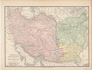
Map with original colour 18.6 x 25.9 cm, central fold, inner margin darkened and outer margin a bit worn but in very good condition. An appealing map showing Iran/Persia, Afghanistan and Beluchistan finely shaded and the borders with Turkey, India, Turkestan and the Russian Empire. Also noting that "Names referring to Ancient Ge…ography are in Light Characters", and recording submarine telegraph cables.

Map Showing Routes of the Pacific Coast Steamship Company.
1889 Rand McNally Map of the Pacific Coast from San Diego to Chilkat, Alaska
- Softcover
- Karte
Anbieter: Geographicus Rare Antique Maps, Brooklyn, NY, USAGeographicus Rare Antique Maps
Verkäufer/-in kontaktierenVerkäufer/-in mit 4 SternenZustand: Gebraucht
EUR 807,66
EUR 14,88 VersandVersand innerhalb von USAAnzahl: 1 verfügbar
Soft cover. Good. Some mended splits, and minor loss at junctures of folds. Size 27 x 12.5 Inches. This is a scarce 1889 Rand McNally map of the Pacific Coast of North America, produced to promote the Pacific Coast Steamship Company just a few years prior to the Klondike gold rush. Coverge embraces the Pacific Coast from the Mex…ican border to British Columbia and Vancouver Island. An inset details from that point north to 'Mousouah Lake' (Mosquito Lake) in Alaska. A Tourist Brochure The target audience for this map was primarily tourists: the verso text pitches a month-long sightseeing journey to Alaska from San Francisco, and the illustrations on the map's covers and cartouche highlight the dramatic vistas. The map's cartouche offers a vignette of the Thousand Islands as viewed from Sitka, while the front cover presents a view of the steamship Idaho navigating Glacier Bay. (For those desiring a warmer journey, the brochure does not neglect the company's southern routes: the back cover shows a fashionable woman and her daughters perambulating Santa Barbara's palm tree orchard.) Rich in Data The map marks out both express and local routes north and south from San Francisco, and features tables indicating distances. The verso details ticket prices, schedules, and ticket agents. The verso text also includes detailed descriptions of featured destinations. The Pacific Coast Steamship Company When this brochure was published, the company was running two steamboats up the coast to Alaska. One of these, the Ancon , would have its career cut short later the same year when it ran aground and broke in Loring, Alaska (happily, without casualty). Since we see editions of this map produced as late as 1911, it must be presumed that this disaster did not ruin the company and that the tourist trade (and the subsequent Yukon Gold Rush) was able to keep them busy. We are left to speculate what other cargos the Steamship Company carried: the ship depicted in the Glacier Bay vignette, the Idaho , had been caught smuggling opium in the early 1880s. Publication History and Census OCLC lists thirteen examples of this map in seven editions ranging between 1886 and 1911. Only two examples of the 1889 edition were located, one at the San Francisco Maritime National Historical Park and the other at the Wisconsin Historical Society Library. References: Rumsey 5232.001 (1896). OCLC 45178306.

- Karte
Anbieter: Geographicus Rare Antique Maps, Brooklyn, NY, USAGeographicus Rare Antique Maps
Verkäufer/-in kontaktierenVerkäufer/-in mit 4 SternenZustand: Gebraucht
EUR 100,96
EUR 14,88 VersandVersand innerhalb von USAAnzahl: 1 verfügbar
Very good. Even overall toning. Text on verso. Size 26.5 x 20 Inches. This is a beautiful example of Rand McNally and Company's 1892 map of Brazil and Guiana. The map depicts from the Orinoco River in Venezuela to Do Sul, including British, Dutch and French Guiana. An inset in the lower right quadrant details the western portion… of Brazil. Part of neighboring Bolivia, Paraguay, Argentina, and Uruguay are also featured. This map was printed shortly after Brazil was declared a Republic following the abdication of Emperor Pedro II. Several Indian tribes are identified throughout. The Marshes of Xarayes are also labeled. Color coded according to countries, the map notes several towns, cities, rivers, mountains, and various other topographical details with relief shown by hachure. This map was issued as plate nos. 170 and 171 in the 1895 issue of Rand McNally and Company's Indexed Atlas of the World - possibly the finest atlas Rand McNally ever issued. References: Rumsey 3565.046 (1897 edition). Philip (atlases) 1026 (1898 edition).

- Karte
Anbieter: Geographicus Rare Antique Maps, Brooklyn, NY, USAGeographicus Rare Antique Maps
Verkäufer/-in kontaktierenVerkäufer/-in mit 4 SternenZustand: Gebraucht
EUR 100,96
EUR 14,88 VersandVersand innerhalb von USAAnzahl: 1 verfügbar
Very good. Text on verso. Size 20 x 13 Inches. An appealing 1892 Rand McNally map or plan of the city of St. Joseph, Missouri. It covers the city east of the Missouri River, noting parks, cemeteries, railway lines, bridges, and various other topographical features. Throughout, individual streets and important buildings are also…identified, including freight houses, court house, post office, etc. This map was issued as plate no. 266 in the 1893 edition of Rand McNally and Company's Indexed Atlas of the World - possibly the finest atlas Rand McNally ever issued. References: Rumsey 3565.127 (1897 edition). Philips (atlases) 1026 (1898 edition).

- Karte
Anbieter: Geographicus Rare Antique Maps, Brooklyn, NY, USAGeographicus Rare Antique Maps
Verkäufer/-in kontaktierenVerkäufer/-in mit 4 SternenZustand: Gebraucht
EUR 126,20
EUR 14,88 VersandVersand innerhalb von USAAnzahl: 1 verfügbar
Good. Wear along original fold lines. Slight loss at fold intersections. Map of United States on verso. Size 28.75 x 17.5 Inches. This is a c. 1953 Rand McNally road map distributed by Sinclair Oil. State and interstate highways are noted with urban areas are shaded yellow. The Everglades National Park stands out in pink. Insets… in the lower left corner focus on the Florida Panhandle and Cuba. Verso Content A highway map of the United States occupies the verso. National Parks and Monuments are indexed along the right. A chart providing distances between major American cities is situated in the lower left corner. Inset maps of Jacksonville, Orlando, Pensacola, Tallahassee, Palm Beach and West Palm Beach, Tampa and St. Petersburg, and Miami and Miami Beach are included. Publication History This map was created and published by Rand McNally and distributed by Sinclair Oil.
- Karte
Anbieter: Tmecca Inc., Seoul, , SüdkoreaTmecca Inc.
Verkäufer/-in kontaktierenVerkäufer/-in mit 2 SternenZustand: Gebraucht - Wie neu
EUR 135,21
EUR 17,49 VersandVersand von Südkorea nach USAAnzahl: 1 verfügbar
No Binding. Zustand: As New.

Grand Canyon National Park, Arizona. / Village and Vicinity Map Services - South Rim.
1975 Rand McNally / Fred Harvey Map the Grand Canyon / View of South Rim
- Karte
Anbieter: Geographicus Rare Antique Maps, Brooklyn, NY, USAGeographicus Rare Antique Maps
Verkäufer/-in kontaktierenVerkäufer/-in mit 4 SternenZustand: Gebraucht
EUR 151,44
EUR 14,88 VersandVersand innerhalb von USAAnzahl: 1 verfügbar
Very good. Light wear along original folds. Map on verso. Size 10 x 15.5 Inches. An impressive 1975 map and view of the Grand Canyon, produced for tourists by Rand McNally and the Fred Harvey Company. A Closer Look The map covers the Grand Canyon centered on the Colorado River, with the location of various notable creeks, rapids…, buttes, cliffs, 'temples,' 'shrines,' 'castles,' and other features in the canyon noted (this unusual nomenclature was the legacy of geologist Clarence Dutton, who played an important role in familiarizing the American public with the grandeur of the canyon). Roads and trails are also indicated, as are buildings, including the collection of buildings on the canyon's South Rim (South Rim Village). Among these are buildings operated by the Fred Harvey Company, including the El Tovar Hotel, Hopi House, and Bright Angel Lodge. The verso consists of a bird's-eye view of the South Rim Village, again highlighting the facilities operated by the Fred Harvey Company. The Fred Harvey Company The Fred Harvey Company was founded by its namesake owner in 1875 as a hospitality business operating along the lines of the expanding railroad network in the Western United States, particularly the Atchison, Topeka, and Santa Fe Railway, with which Harvey eventually developed a special contractual relationship. Building restaurants and later hotels, dubbed Harvey Houses, within or adjacent to train stations, especially in smaller towns, Harvey developed a reputation for providing fast, efficient, and clean service to weary travelers. At its peak, the Fred Harvey Company ran 84 hotels and restaurants along the railway from Topeka to San Francisco, with many locations in Colorado, New Mexico, and Arizona. Later, the company expanded into demonstrations of Native American crafts and 'Indian Detours,' which took tourists in private 'Harvey Cars' from rail stops into Indian Country. Thus, the Harvey company was an integral part of tourism and migration to the American West at the turn of the 20th century. The Grand Canyon took on special significance for the Fred Harvey Company, as it was the main tourist destination reached by the Atchison, Topeka, and Santa Fe (via the Grand Canyon Railway, completed 1905, which was an extension of the pre-existing Santa Fe and Grand Canyon Railroad, constructed for mining purposes). The Harvey Company built restaurants and lodges, operated the aforementioned automobile coach service, and sold souvenirs to tourists at the Grand Canyon. Perhaps the most impressive operation was the El Tovar Hotel, built directly on the South Rim of the canyon near the Atchison, Topeka, and Santa Fe's Grand Canyon Depot. In the mid-20th century, the company expanded further, building or acquiring hotels and restaurants throughout the West, Midwest, and Plains States, including the famous Furnace Creek Inn in Death Valley. In 1968, after the death of Fred Harvey's grandson, the Fred Harvey Company was purchased by American Factors (Amfac, Inc., renamed Xanterra Travel Collection in 2002). Today, Xanterra continues to operate several former Harvey Houses, including El Tovar, while others have been converted to museums or for other uses. Publication History and Census This map was prepared by Rand-McNally for the Fred Harvey Company, while the view on the verso is not attributed. It is undated, but the designation at bottom-right, along with context and the style of the map and text suggest a date of 1975. Maps with this title were produced between the early 1970s and early 1990s, and the present edition is noted among the collections of eight institutions in the OCLC. References: OCLC 7668886.

- Karte
Anbieter: Geographicus Rare Antique Maps, Brooklyn, NY, USAGeographicus Rare Antique Maps
Verkäufer/-in kontaktierenVerkäufer/-in mit 4 SternenZustand: Gebraucht
EUR 151,44
EUR 14,88 VersandVersand innerhalb von USAAnzahl: 1 verfügbar
Very good. Text on verso. Size 20.5 x 13 Inches. This is a beautiful example of Rand McNally and Company's 1892 map of New Zealand. It covers It covers the entire island country from Cape Reinga (C. Maria Van Diemen) to Stewart Island. An inset map in the upper left quadrant details Tasmania while another inset below details Kin…g Island. Two insets of the Fiji Islands and Chatham Islands are featured in the lower right quadrant. This map was drawn just one year before New Zealand became the world's first country to grant voting rights to all women. The map is color coded according to regions, and notes several towns, cities, rivers, mountains and various other topographical details with relief shown by hachure. This map was issued in the 1895 issue of Rand McNally and Company's Indexed Atlas of the World - possibly the finest atlas Rand McNally ever issued. References: Rumsey 3565.042 (1897 edition). Philip (atlases) 1026 (1898 edition).
 Weitere Bilder
- Karte
Anbieter: Geographicus Rare Antique Maps, Brooklyn, NY, USAGeographicus Rare Antique Maps
Verkäufer/-in kontaktierenVerkäufer/-in mit 4 SternenZustand: Gebraucht
EUR 176,68
EUR 14,88 VersandVersand innerhalb von USAAnzahl: 1 verfügbar
Very good. Light wear along original fold lines. Maps of the United States and Salt Lake City on verso. Accompanied by original binder. Size 27.25 x 21.25 Inches. This is a 1924 Rand McNally road map of Utah. Distributed by the Continental Oil Company, the map highlights Utah's highway network. Several named highways traverse th…e state, including the Lincoln Highway and the National Park to Park Highway, and are marked by small bold placards along the routes. Cities and towns throughout the state are identified, with the largest cities (such as Salt Lake City) appearing in the largest text. Populations are noted next to many cities and towns, and distances between them are provided. Mountains, lakes, and other landmarks are identified. Advertisements for Conoco Gasoline and the Continental Oil Company occupy the top portion of the sheet above the map. Verso Content Two maps occupy the verso. One is a map of Salt Lake City, which identifies major roadways and railroads within the city. The second is a map of the United States highlighting national parks and monuments across the country. Major parks, such as Yellowstone and Yosemite, are marked using diagonal lines to fill in their area. Forty-eight other parks are marked by stars and numerically identified. These numbers correspond with a key situated in the lower left corner. Twenty-seven named highways across the country, such as the Lincoln Highway, the Dixie Highway, and the Atlantic-Pacific Highway, are illustrated and numerically identified. The corresponding index occupies the lower right corner. Publication History and Census This map was created and published by Rand McNally in 1924 and distributed by the Continental Oil Company. We note a single cataloged example in OCLC which is part of the collection at the Newberry Library. References: OCLC 993879837.

- Karte
Anbieter: Geographicus Rare Antique Maps, Brooklyn, NY, USAGeographicus Rare Antique Maps
Verkäufer/-in kontaktierenVerkäufer/-in mit 4 SternenZustand: Gebraucht
EUR 191,82
EUR 14,88 VersandVersand innerhalb von USAAnzahl: 1 verfügbar
Very good. Light wear along original fold lines. Exhibits slight loss at fold intersections. Map of southeastern United States on verso. Size 26.5 x 29.25 Inches. This is a c. 1940 Rand McNally and Pure Oil map of Florida. 'Main through routes', as they are referred to in the key, are illustrated by thick red lines, allowing the… traveler or tourist in possession of this map to easily identify the best way to their destination. These were also known as interstate highways, which are different from today's interstates, which did not begin construction until 1956 under the auspices of President Dwight D. Eisenhower. State highways are illustrated by blue lines, with thinner lines marking roads of less dependable grades. Cities and towns throughout the state are labeled, and distances between them are provided as well. Points of interest, including state parks and many tourist attractions, are all labeled in red, allowing them stand out. An inset map of western Florida is situated in the Gulf of Mexico and a mileage table and short descriptions of places of interest in Florida occupy the lower right quadrant. Dating the Map As this map is undated, precisely dating the map is difficult. We believe that the presence of the old Florida State Road numbering system, which we noticed because the Overseas Highway is labeled here as Highway 4A, that this map dates from around 1940. Florida State Roads were renumbered in 1945. Marineland of Florida, situated along the coast between Saint Augustine and Daytona Beach, was a popular tourist attraction opened in Florida in 1938, and thus we have postdated the map slightly to account for its presence on the map. Publication History and Census This map was created by Rand McNally and published by the Pure Oil Company c. 1940. We have been unable to locate any other examples.

- Karte
Anbieter: Geographicus Rare Antique Maps, Brooklyn, NY, USAGeographicus Rare Antique Maps
Verkäufer/-in kontaktierenVerkäufer/-in mit 4 SternenZustand: Gebraucht
EUR 201,92
EUR 14,88 VersandVersand innerhalb von USAAnzahl: 1 verfügbar
Good. Some wear along original fold lines. Verso repairs to fold separations. 2 closed tears each extending 2 inches into printed area professionally repaired on verso. Old adhesive evident on verso. Size 20 x 26 Inches. This is a 1958 Rand McNally map of the Solar System. A Closer Look The map focuses on the Solar system, illus…trating the planets, with moons orbiting Earth, Mars, Jupiter, Saturn, Uranus, and Neptune. The distance in miles between the orbits is provided, as is the distance traveled in each orbit, the length of time spent in one orbit (given in Earth years), and the time it takes for each planet to complete one revolution. The asteroids Ceres and Eros are illustrated in the Asteroid Belt between Mars and Jupiter, and a note states that between 1,500 and 50,000 asteroids are known to exist within the belt. Other celestial formations are noted as well, including Antares, Magellanic clouds, the Crab Nebula, and the Andromeda Galaxy. Text boxes and inset views create a frame and provide information concerning interplanetary and intergalactic distances, the relative size of the planets in the Solar System, an artist's rendering of Eros and Ceres, a chart of interplanetary weights, and artist renderings of a volcanic eruption on Mercury, canals on Mars, the Rings of Saturn, methane storms on Venus, Jupiter's Great Red Spot, and Earth as seen from the Moon. Publication History This map was created and published by Rand McNally and Company in 1958. At least three different states of this map were published with the same copyright date (1958). There were no major changes in the content of the map between states, the only alteration being to the map's title. An edition (of which the presently offered example is extant) was published at a reduced size.

- Karte
Anbieter: Geographicus Rare Antique Maps, Brooklyn, NY, USAGeographicus Rare Antique Maps
Verkäufer/-in kontaktierenVerkäufer/-in mit 4 SternenZustand: Gebraucht
EUR 201,92
EUR 14,88 VersandVersand innerhalb von USAAnzahl: 1 verfügbar
Very good. Newsprint. Light wear along original centerfold. Closed minor margin tears professionally repaired on verso. Loss to lower right margin corner not effecting printed area. Old tape repairs evident on verso. Size 16.75 x 22 Inches. This is a 1940 Rand McNally and Chicago Sunday Tribune map of Europe during World War II…(1939 - 1945). This map, published on May 19, 1940, appeared nine days after Germany invaded Belgium, the Netherlands, and France. It highlights fortifications and air and naval bases throughout Europe and across the Mediterranean Sea in Europe and the Middle East. History as it Happened At the time of publication, readers in Chicago were likely following events in Europe with trepidation, as the western Allies had been dealt defeat after defeat at the hands of the German army. The world believed France militarily unassailable behind stalwart and well-planned defenses. However, only weeks after this piece appeared on street corners in Chicago, all three countries fell to the German onslaught. A Closer Look Icons mark naval (anchor) and air (plane) bases across Europe. Artillery pieces highlight fortifications, including the Maginot and Siegfried lines. These two celebrated fortifications are also highlighted in France and Germany by notations indicated in the legend in the lower left. Fortifications, air, and naval bases are marked in the Middle East and North Africa as well. Publication History and Census This map was created by Rand McNally and Company and published by the Chicago Sunday Tribune on May 19, 1940. We note a single cataloged example which is part of the collection at the Newberry Library. References: OCLC 1032553536.

- Karte
Anbieter: Geographicus Rare Antique Maps, Brooklyn, NY, USAGeographicus Rare Antique Maps
Verkäufer/-in kontaktierenVerkäufer/-in mit 4 SternenZustand: Gebraucht
EUR 201,92
EUR 14,88 VersandVersand innerhalb von USAAnzahl: 1 verfügbar
Very good. Dissected and laid on linen. Some discoloration at top margin and top-left. Size 32 x 22.5 Inches. Here is a large-scale linen-backed folding wall map of North America produced by Rand McNally and Co. c. 1949. Both attractive and comprehensive, it combines political, topographical, and other information in a style cha…racteristic of the 'Ranally' series produced in the mid-20th century. A Closer Look This is a versatile map in every sense. It can be folded onto itself and carried in one arm but also has grommets installed at the top corners for wall hanging. It includes a wide variety of information on political boundaries, cities, transportation, topography, and maritime navigation (a notable feature is the inclusion of ocean depths). Insets are provided at top-left and at bottom-right, respectively depicting the Aleutian Islands and Puerto Rico with the Lesser Antilles. The provinces of Canada and the states and territories of the U.S. and Mexico are indicated. The map employs Lambert azimuthal equal area projection, with a point of tangency located near Bismarck, North Dakota, at roughly the mid-point of the continent. This projection is especially well-suited to the mapping of hemispheres and continents (as opposed to the entire globe). Publication History and Census This map was produced by Rand-McNally in or around the year 1949, number 'RB100' in the Ranally series of the company's political-physical maps. It is only cataloged among the holdings of the University of Denver and Syracuse University, and is scarce to the market. References: OCLC 933302618.
 Weitere Bilder
- Karte
Anbieter: Geographicus Rare Antique Maps, Brooklyn, NY, USAGeographicus Rare Antique Maps
Verkäufer/-in kontaktierenVerkäufer/-in mit 4 SternenZustand: Gebraucht
EUR 252,39
EUR 14,88 VersandVersand innerhalb von USAAnzahl: 1 verfügbar
Very good. Light wear along original fold lines. Advertisement on verso. Accompanied by original binder. Size 13.25 x 19 Inches. Celebrating Ohio's centennial, this 1888 Whitely and Rand McNally map of Ohio recognizes one of Ohio's most successful businesses, Whiteley's. Amos Whitely and his brother William operated farm equipme…nt businesses in Springfield, Ohio after William patented improvements to the reaper, a grain and grass harvester. William's invention garnered worldwide attention and earned him the nickname 'Reaper King'. An advertisement for Whiteley's occupies the entire verso. A Closer Look The map focuses on the Ohio railroad network, with each line identified by name. The highlight is an advertisement for Amos Whiteley's solid steel mower in the lower right. Publication History and Census This map was created by Rand McNally and Company and published by Amos Whiteley and Company in 1888. We note three examples cataloged in OCLC: Cleveland Public Library, the Ohio History Connection, and the University of Michigan. An example is also part of the David Rumsey Map Collection. References: Rumsey 0827.002. OCLC 36623980.
 Weitere Bilder
- Karte
Anbieter: Geographicus Rare Antique Maps, Brooklyn, NY, USAGeographicus Rare Antique Maps
Verkäufer/-in kontaktierenVerkäufer/-in mit 4 SternenZustand: Gebraucht
EUR 252,39
EUR 14,88 VersandVersand innerhalb von USAAnzahl: 1 verfügbar
Good. Verso repairs to fold separations. Map of California highways on verso. Size 37.75 x 33 Inches. This is a c. 1921 Rand McNally railroad map of California. Black lines trace railroad lines throughout the state, most of which are labeled along their respective route. Red overprinted numbers (1 to 157) correspond with an inde…x in the upper right. Red overprinted dashed and dotted lines highlight operating electric railroad lines. Red dashed lines off the coast represent steamship lines, the majority of which operate out of San Francisco, while most of the remainder depart from Los Angeles. Inset maps of San Francisco, Los Angeles, and San Diego appear in the upper right. An index of California's principal cities appears outside the left border. Verso Content A Rand McNally highway map of California is printed on the verso. Green overprinting highlights the state's many named highways, including the National Park to Park Highway, the Lincoln Highway, the Roosevelt National Highway, and the Pacific Highway. An inset of the San Francisco Bay Area appears in the upper right quadrant. Publication History and Census This map was created and published by Rand McNally c. 1921. We note a single example of the present map cataloged in OCLC which is part of the collection at the University of California Berkeley. It appears on the private market from time to time. References: OCLC 81616229.
 Weitere Bilder
- Karte
Anbieter: Geographicus Rare Antique Maps, Brooklyn, NY, USAGeographicus Rare Antique Maps
Verkäufer/-in kontaktierenVerkäufer/-in mit 4 SternenZustand: Gebraucht
EUR 302,87
EUR 14,88 VersandVersand innerhalb von USAAnzahl: 1 verfügbar
Very good. Exhibits wear along original fold lines. Verso repair at a fold intersection and at fold separations. Closed margin tear professionally repaired on verso. Text and printed maps on verso. Size 39.75 x 17.75 Inches. This is a c. 1950s Rand McNally pictorial road map of Florida designed for the Gulf Oil Corporation. The…map depicts the state from Tallahassee and the Gulf of Mexico to the Atlantic Ocean and from Georgia to Key West. Highly detailed, myriad cities and towns throughout Florida are labeled, including Tallahassee, Tampa, St. Petersburg, Orlando, Jacksonville, West Palm Beach, Fort Lauderdale, and Miami. Everglades National Park occupies a large portion of the southern part of the state, while other national forests, state parks, and state forests are scattered throughout. Other tourist destinations, such as the Devil's Punch Bowl, the circus winter quarters, and the Ocean Beach Speedway are highlighted by small, eye-catching vignettes. Florida is a major destination for fishing enthusiasts, and this map highlights thirty-two different species of fish that could be caught in Florida's rivers and lakes, as well as along its coastlines. Publication History and Census This map was designed by Rand McNally for the Gulf Oil Company and published in the 1950s. At least two states of this map were published. One state (of which the offered example is representative) includes an inset key map to the right of the map's title. On the other state this key map is absent. Unfortunately we are not certain which state precedes the other.
 Weitere Bilder
- Karte
Anbieter: Geographicus Rare Antique Maps, Brooklyn, NY, USAGeographicus Rare Antique Maps
Verkäufer/-in kontaktierenVerkäufer/-in mit 4 SternenZustand: Gebraucht
EUR 353,35
EUR 14,88 VersandVersand innerhalb von USAAnzahl: 1 verfügbar
Very good. Light wear along original fold lines. Text on verso. Size 21.25 x 34 Inches. This is a 1944 pictorial highway map of the state of Washington, prepared by Rand McNally for the Washington Department of Highways. A Closer Look Bright red highlights state highways, with notations indicating road grades (double pavement, p…aved, improved, and dirt roads). Cities and towns are labeled throughout the state, with Spokane, Seattle, and Tacoma appearing in large bold lettering. Bright red areas highlight Mount Rainier National Park and Olympic National Park. Counties are divided by yellow lines to allow for differentiation. The whole is surrounded by a pictorial border featuring images of Olympic National Park, Grand Coulee, Mount Rainier, Yakima Canyon, and the Grand Coulee Dam, along with others. Verso Content The verso contains information provided by the Automobile Club of Washington, the local affiliate of the Automobile Association of America (AAA), including the state's motor vehicle regulations and information for dealing with Canadian customs when crossing the border. Promotional text also discusses various attractions in the 'evergreen playground,' such as Puget Sound, Mount Rainier, and the Grand Coulee Dam, which had only become operational two years prior. A mileage chart with distances between various sites and cities in Washington appears near the title panel. Four inset maps of Tacoma, Seattle, Bellingham, and Yakima appear at the bottom right. Publication History and Census This map was prepared by Rand McNally and Company, lithographed by the North Pacific Bank Note Company, and published in 1944 by the State of Washington Department of Highways and AAA. Editions of this map were published in 1939, 1941, 1942, 1944, and 1949 (all of which have been digitized by the Washington State Department of Transportation Library), leading to some confusion in catalog listings. In fact, there are two 1944 printings, one with images and photographs on the verso published solely by the Department of Highways and the present example with information for AAA on the verso. From one edition to the next, the map appears to be unchanged while the verso content differs. Nonetheless, the map is scarce on the market, and the OCLC seems to record both 1944 printing in only six institutions, while an example is also held by the Washington State Department of Transportation Library (with the Department of Highways verso) and the David Rumsey Historical Map Collection. References: Washington State Department of Transportation Library Highways of the State of Washington, 1944 1. Rumsey 9783.002. OCLC 35226338.
 Weitere Bilder
Geographically correct map of the United States issued by Union Pacific Railroad.
1942 Rand McNally / Union Pacific Military Map of the United States
- Karte
Anbieter: Geographicus Rare Antique Maps, Brooklyn, NY, USAGeographicus Rare Antique Maps
Verkäufer/-in kontaktierenVerkäufer/-in mit 4 SternenZustand: Gebraucht
EUR 353,35
EUR 14,88 VersandVersand innerhalb von USAAnzahl: 1 verfügbar
Very good. Some wear along fold lines and offsetting. Size 17.5 x 31 Inches. A 1942 World War II era Rand McNally map of the United States issued for the Union Pacific Railroad. It notes the locations of military facilities and highlights the contributions of the Union Pacific to the war effort. A Closer Look Black lines trace t…he Union Pacific network and associated lines, marked as either single or double track, while lighter gray lines represent the trackage of other companies. Military bases, airfields, forts, naval bases, and other facilities are indicated with red squares, airplanes, and anchors. Inset maps at the bottom-left and bottom-right illustrate connecting shipping lines across the Pacific and Atlantic Oceans. Rivers, mountains, cities, national parks, and state borders are also indicated. The verso includes an extensive list of military installations organized alphabetically, a list of Union Pacific offices around the country, and a section describing Union Pacific's contributions to the war effort. American Railroads and World War II During World War I (1914 - 1918), American railroad lines were nationalized and placed under the management of the United States Railroad Administration. This system was unwound after the Great War, scarcely two years after its establishment. Still, in its brief existence, the U.S.R.A. oversaw important investments in rail infrastructure, standardization measures, and regulatory changes. However, the interwar period was difficult for the railroads, especially passenger rail, as competition from automobiles and aviation, along with the Great Depression, hurt ridership. Still, the continued oversight and standardization of the rail network (by the Interstate Commerce Commission) proved to be a boon during World War II (1939 - 1945), obviating the need for another wartime nationalization while allowing for the smooth interaction of various private railroads to support the war effort. Publication History and Census This map was prepared by Rand McNally and Company and issued by the Union Pacific Railroad in 1942. The copyright names C. J. Collins, the company's General Passenger Traffic Manager, also credited in several other contemporanous maps and publications. Union Pacific had issued several editions of its 'Geographically Correct Map of the United States' prepared by Rand McNally in the 1920s and 1930s. The present example is a significantly modified wartime edition, touting the Union Pacific network as 'The Strategic Middle Route.' The present edition is listed in the OCLC among the holdings of the University of California Santa Cruz, the University of Kansas, Missouri State University, and the University of Michigan. References: Rumsey 11259.003. OCLC 429905439.

- Karte
Anbieter: Geographicus Rare Antique Maps, Brooklyn, NY, USAGeographicus Rare Antique Maps
Verkäufer/-in kontaktierenVerkäufer/-in mit 4 SternenZustand: Gebraucht
EUR 353,35
EUR 14,88 VersandVersand innerhalb von USAAnzahl: 1 verfügbar
Very good. Some toning at bottom-left along fold lines and in margin. Size 26 x 19 Inches. A 1910 Rand McNally pocket-style folding map of Montana. It presents geographic, administrative, and economic information in rich detail, combining utility and aesthetics. A Closer Look This map covers the state of Montana identifying coun…ties, rivers, topography, and railroads, which are listed in red text at bottom-right. Cities and towns are listed at top-left according to their population and are given a coordinate corresponding to the numbered and lettered grid system in the margins. It includes several national parks, national forests, and Indian reservations. These systems were quite young and still evolving, with borders and names changing frequently. For example, both the Big Hole and Hell Gate National Forests southeast of Missoula were divvied up in 1908 and reapportioned to other nearby parks, so that Bitter Root (now stylized as Bitterroot) National Forest extended into southwestern Montana. Historical Context At this time, Montana was still in the early phase of statehood and becoming more integrated with the economy and infrastructure of surrounding states. The recent tumult of the Indian Wars and the rapid increase in white settlers (many seeking gold) in the late 19th century would have been fresh in people's minds. The railroads and the confinement of Native Americans to reservations led to a continual increase in white settlers, who then demanded more land, coming into conflict with native peoples and restoking tensions. Pitched battles had been fought as recently as 1887 (the Battle of Big Hole) and legal disputes continued, as additional land was sheaved off from reservations. For instance, in 1904 the U.S. Congress passed an act 'allotting' land in individual parcels to indigenous people on the Flathead Indian Reservation and then claiming the remaining communal land, roughly one-half of the reservation's land, to be 'surplus,' which was then doled out to white settlers. Then in 1908, a skirmish (known as the Swan Valley Massacre) occurred between Pend d'Oreilles hunters and a Montana state game warden. The hunters resided on the Flathead Reservation but had treaty rights to hunt beyond its borders, a fact that irritated nearby white settlers. The game warden and an armed posse tried to chase off the Pend d'Oreilles several times, and eventually resorted to shooting, leaving four Native Americans and the warden dead. In the early 20th century, provisions were made in adjustments to the Homestead Act to offer ever larger tracts of land to homesteaders, mostly from the Midwest, to settle in Montana. Large-scale irrigation projects also facilitated agriculture and attracted settlers. Meanwhile, mining moved beyond gold prospecting to coal, copper, and oil, and incorporated advanced technologies, while the vast forests of western Montana were the source for a timber boom that lasted several decades. The development of railroads both facilitated and intensified these processes. Publication History and Census This map was published by Rand, McNally, and Co. in 1910, based on their New Business Atlas map of Montana. Two copyrights are indicated here, suggesting that an existing 1909 map was updated in 1910, primarily to incorporate data from the 1910 census. Rand McNally maps of Montana in this format, as a separate issue with a title including 'Indexed County and Township Pocket Map and Shippers Guide,' date from the 1880s and to the mid-1910s, though they do not always include a dated copyright. Despite the wide date range, they are relatively scarce. We note three examples of the 1910 edition cataloged in OCLC: University of Texas at Arlington, Brigham Young University, and the University of Utah. References: OCLC 44878972.

Map of Routes to the Holland Tunnel. / The Holland Tunnel Twin Tubes Map of Routes Description of Tunnel Toll Rates Traffic Regulations.
1927 Rand McNally Map of New York City, Holland Tunnel Opening
- Karte
Anbieter: Geographicus Rare Antique Maps, Brooklyn, NY, USAGeographicus Rare Antique Maps
Verkäufer/-in kontaktierenVerkäufer/-in mit 4 SternenZustand: Gebraucht
EUR 403,83
EUR 14,88 VersandVersand innerhalb von USAAnzahl: 1 verfügbar
Very good. Light wear along original fold lines. Verso repair to a fold separation. Very slight loss at a few fold intersections. Text and map of the Holland Tunnel on verso. Size 15.25 x 17.25 Inches. This is Rand McNally's c. 1927 map of New York City, produced to highlight the opening of the Holland Tunnel, the first direct a…utomobile crossing of the Hudson River, and one of the great engineering marvels of its time. A Closer Look This map covers New York City and parts of Westchester County, New Jersey, and Long Island. Highways and other major roads are traced, with airports, parks, bridges, and neighborhoods identified. The Holland Tunnel is highlighted in red near center, while distances to the tunnel are recorded as red 'x's at highway and major road interchanges. A legend and inset map displaying the wider metropolitan area appear at bottom-left. Text on the verso describes the design and construction of the tunnel, toll rates, and regulations. This information is both informative and historically significant; for instance, the text states that the granite roadway was designed to accommodate 1900 vehicles per hour, though the demands placed on it soon exceeded these numbers, and today, the tunnel handles nearly double this number (largely due to increased night usage). The verso also includes a cross-section schematic of the tubes on the title panel, along with a plan and profile of the tunnel. Overcoming Engineering Challenges Engineers in the early 20th century gained substantial expertise in tunnel construction in and around New York City through projects such as the Long Island Railroad, the Pennsylvania Railroad, and the Hudson and Manhattan Railroad (now part of the PATH system), which involved boring tunnels beneath both the Hudson and East Rivers. Their success provided impetus to early discussions of similar infrastructure for vehicular use. Explorations of a 'Hudson River Vehicular Tunnel' began as early as 1906 - remarkably prescient given the paucity of automobiles at that date. Planners were motivated by the inconvenience of relying on ferries for both passenger vehicles and freight. In addition to the usual wrangling over where to place the tunnel and how to fund its construction, designing a tunnel for automobiles presented other novel problems, in particular how to handle potentially deadly vehicular exhaust. Construction began on April 1, 1922. The tunnel was designed by Clifford Milburn Holland (1883 - 1924), who served as chief engineer on the project from 1919. Holland had prior experience designing tunnels under the East River for the subway. Holland's greatest challenge was ventilating carbon monoxide exhausted from automobiles, an issue he resolved with dozens of blowers and exhaust fans along with four massive ventilation shafts designed to be inconspicuous with exteriors resembling contemporary office buildings. At the same time, massive amounts of fresh air are blown into the tunnel so that the air fully circulates every minute and a half. Holland worked so feverishly on the tunnel project that he suffered a nervous breakdown in 1924 and died shortly thereafter from a heart attack. In the wake of Holland's death, the tunnel project was renamed in his honor. His successor as chief engineer, Milton H. Freeman (1871 - 1925), also died after only four months on the job; a square near the tunnel's Manhattan entrance was named in his honor, Freeman Plaza. These tragedies left the Norwegian-born Ole Singstad (1882 - 1969) as chief engineer at the tunnel's opening. Singstad went on to design the Lincoln Tunnel, Brooklyn-Battery Tunnel, and Queens-Midtown Tunnel. Although the tunnel was opened some three years behind schedule and significantly over budget, it proved a popular and essential part of the infrastructure of New York City. Publication History and Census This map was designed by Rand McNally for the New York State Bridge and Tunnel Commission and the New Jersey Holland Tunnel Commission. It.

Mexico, compliments of Greene Consolidated Gold Company.
1904 Rand McNally Map of Mexico showing the Sonora Copper Mines
- Karte
Anbieter: Geographicus Rare Antique Maps, Brooklyn, NY, USAGeographicus Rare Antique Maps
Verkäufer/-in kontaktierenVerkäufer/-in mit 4 SternenZustand: Gebraucht
EUR 403,83
EUR 14,88 VersandVersand innerhalb von USAAnzahl: 1 verfügbar
Fair. Original binder attached. Damage to lower third of index. Professional repairs along fold separation and fold intersections on verso. Area of infill at border between ChihuahuaandTexas. Size 19 x 26 Inches. A historically-significant 1904 Rand McNally map of Mexico issued by the Greene Consolidated Gold Company, one of sev…eral ventures owned by William Cornell Greene, an American businessman who operated a massive copper mine at Cananea, Sonora. The map was meant to entice American investors to fund Greene's sprawling empire, one destined to rapidly collapse only two years later. A Closer Look The entirety of Mexico is depicted with states shaded for distinction. Red text overlays highlight railways and Greene's mines. An inset map of Sonora at bottom-left further emphasize Greene's mines and related ventures. Mountains, rivers, and other geographic features are clearly indicated, along with cities, railroads, and ports. An alphanumeric grid surrounds the map, corresponding to an index of cities and their populations at left. Mining, Resistance, and Revolution At this time, Sonora had seen nearly two decades of resistance by Yaqui and other indigenous peoples against intrusion by central authorities and economic interests, especially agriculture and mining. The U.S.-aligned Porfirio Díaz government was eager to exploit the region's natural resources and readily worked with exploitive U.S. business interests. The Greene Consolidated Cooper and Gold Companies referenced here were owned by William Cornell Greene, a surveyor and prospector who in 1899 discovered vast copper reserves at Cananea, Sonora, near the Arizona border. Parlaying his gains in copper, Greene rapidly founded several other ventures, including the gold mining company as well as a railroad and numerous cattle ranches on both sides of the U.S.-Mexico border. These endeavors made him incredibly wealthy and allowed him to effectively run large portions of Sonora as a personal fiefdom. To facilitate these efforts, the Mexican government systematically expelled rebellious indigenous populations to Henequen plantations in the distant Yucatán. Outside laborers, including from as far away as China, were brought in to work the mines, though rough conditions and low pay led to labor unrest. In 1906, a large-scale strike at Greene's mine was violently suppressed by a contingent Arizona Rangers and American volunteers. The incident scared off investors and ruined Greene, who was forced to sell his assets to business partners; afterwards, he retreated into obscurity at his home in Cananea. It was also a debacle for the Díaz government and in retrospect has been considered a precursor to the Mexican Revolution. Publication History and Census This map was drawn and published by Rand McNally and issued by the Greene Consolidated Gold Company in 1904. It is listed among the holdings of roughly twenty institutions in OCLC and is scarce to the market. References: OCLC 857243099.

- Karte
Anbieter: Geographicus Rare Antique Maps, Brooklyn, NY, USAGeographicus Rare Antique Maps
Verkäufer/-in kontaktierenVerkäufer/-in mit 4 SternenZustand: Gebraucht
EUR 403,83
EUR 14,88 VersandVersand innerhalb von USAAnzahl: 1 verfügbar
Good. Fold lines visible with wear at fold intersections. Dampstaining in left margin along edge. Sporadic spots of discoloration. Size 12.5 x 19 Inches. This is a scarce 1895 separate-issue pocket map of Wyoming published by Rand McNally. It depicts the entire state, only elevated from a territory five years prior, with a range… of administrative, geographic, and infrastructural information. The map may be derived from Rand McNally's atlas map of the same year, but exhibits red overprinting for titling and other important data. A Closer Look The map is bordered by a grid of letters and numbers in the margins for location of features in a corresponding index. It is rather unusual in that Rand McNally indexed pocket maps from this era generally include the index on the recto (front), continued on the verso if necessary. In this case, it appears that the index was included on a separate sheet that has been lost. Black lines indicate railroads, which are tagged to a list at top-left. Elevation is illustrated by hachure, with mountains and hills labeled. Rivers, creeks, and lakes are also noted. The subcounty level grids created by the intersections of 'standard parallel north' lines and auxiliary or guide meridians relate to land surveys conducted in the American territories in the preceding decades. Yellowstone National Park is included in full at top-left. To its immediate right is the Yellowstone Park Timber Land Reservation, the first national forest in the U.S., created by the General Revision Act (also known as the Forest Reserve Act) of 1891. Further south, still in western Wyoming, is the Shoshone or Wind River Indian Reservation, among the larger Indian Reservations in the U.S., both in terms of population and land. It is home to both Eastern Shoshone and Northern Arapaho peoples, who were pushed together when the Arapaho were chased out of their ancestral homeland in the Pike's Peak Gold Rush and the Colorado War (1864 - 1865). The U.S. Army resettled them at Ft. Washakie until a permanent reservation location could be agreed upon, but such an agreement never came, causing a quarrel with the Shoshone who had already been guaranteed the surrounding territory. The land dispute was only settled by the U.S. Supreme Court decades later and remains a sore spot between the two tribes despite gradually improving relations in the decades since. Wyoming was still a sparsely-populated frontier at the time this map was published. Nevertheless, the suitability of the land for grazing livestock could lead to disputes, as with the Johnson County War of 1892. Other forms of frontier violence also occurred, most notoriously the Rock Springs Massacre of 1885 that targeted Chinese miners. Publication History and Census This map was published by Rand McNally in 1895, based on the 1891 map of Wyoming in their Indexed Atlas of the World . As a separate issue pocket map, it is very rare, only being listed among the collections of the Newberry Library and with no known history on the market. References: OCLC 1001313488.

- Karte
Anbieter: Geographicus Rare Antique Maps, Brooklyn, NY, USAGeographicus Rare Antique Maps
Verkäufer/-in kontaktierenVerkäufer/-in mit 4 SternenZustand: Gebraucht
EUR 454,31
EUR 14,88 VersandVersand innerhalb von USAAnzahl: 1 verfügbar
Good. Wear along fold lines and small areas of loss at fold intersections. Size 24 x 14.5 Inches. An impressive c. 1929 indexed folding map of New York City, detailing downtown and midtown Manhattan with portions of Brooklyn, Queens, and New Jersey. It was issued by Rand McNally for the Baltimore and Ohio Railroad. Although publ…ished in the 'golden age of rail' in the United States, it hints at the eventual triumph of automobiles. A Closer Look Coverage extends from 65th Street to the Statue of Liberty and from the Hudson River and Jersey City in the west to Long Island City and Downtown Brooklyn in the east. An alphanumeric grid along the border corresponds to an index at left including points of interest, hotels, theaters, and steamship lines. Several features on this map give a sense of its date, particularly the tunnels and subway lines (or lack thereof). When this map was published, the Holland Tunnel had recently been opened, seen here as the New York - New Jersey Vehicular Tunnel (Lincoln Tunnel was not opened until 1934 and the Queens Midtown Tunnel not until 1940). At this time, the subway system was divided between the Interborough Rapid Transit Company (I.R.T.) and BrooklynManhattan Transit Corporation (B.M.T.). In 1932, the 'Independent' City-Owned Subway opened with the Eighth Avenue Line. In 1940, all these lines would be merged under the ownership and management of the city, reorganized under the New York City Transit Authority in 1953, which itself was placed under the administration of the Metropolitan Transportation Authority in 1968. Meanwhile, the elevated trains in Manhattan along First, Second, Third, Sixth, and Ninth Avenue were gradually eliminated, with the last service ending in 1955. The southern portion of the New York Central Railroad line along Ninth and Tenth Avenues noted here was used for freight but with decreasing frequency. After sitting dormant for years, it was reopened as the acclaimed High Line park in 2009. Verso Content The verso includes a range of information, including practical matters, such as the location of ticket offices and procedures for handling baggage, as well as photographs of attractions in the city. Most of the space, however, is dedicated to touting the Baltimore and Ohio's motor coach services. This service was the result of the B and O having no tunnel rights to the tracks running into Manhattan, unlike the Pennsylvania Railroad. Therefore, rail service terminated at the Central Railroad of New Jersey Terminal along the Hudson River in Jersey City, after which passengers took a ferry to Manhattan and then boarded motor coaches (buses) to stops throughout Manhattan and Brooklyn. Although a necessary accommodation to their lack of tunnel rights, the B and O's embrace of motor coaches, in retrospect, also signaled the rise of automobiles and the decline of intercity passenger rail in the U.S. This development was aided in New York City by the urban planning philosophy championed by Robert Moses, which prioritized automobile traffic. The verso also includes two inset maps, one at center of the entire B and O system and a larger map at bottom-right displaying the approach of the B and O to Jersey City, including a motor coach connection from Elizabeth to Newark. Publication History and Census This map was issued by the Baltimore and Ohio Railroad, but the map itself is copyrighted by Rand McNally, which produced similar brochures for the B and O with some regularity in the 1920s - 1930s (afterwards, Hagstrom maps were used for B and O brochures into the 1950s). The present map is the 9th edition, cataloged by the New York Public Library as 1929, which corresponds to the tunnels, subway lines, and other features present. In any edition, these brochures are quite rare. We are only aware of this edition being held by the NYPL, while other editions are held by nine other institutions. References: OCLC 883250788.

Mapa modelo de los Estados Unidos de Brazil, La Repu?blica Oriental del Uruguay y Paraguay.
1924 Rand McNally Spanish-language Map of Brazil, Paraguay, Uruguay
- Karte
Anbieter: Geographicus Rare Antique Maps, Brooklyn, NY, USAGeographicus Rare Antique Maps
Verkäufer/-in kontaktierenVerkäufer/-in mit 4 SternenZustand: Gebraucht
EUR 454,31
EUR 14,88 VersandVersand innerhalb von USAAnzahl: 1 verfügbar
Very good. Slight discoloration along fold lines and in upper-left margin. Size 42 x 28 Inches. This is a very rare Spanish-language c. 1924 Rand McNally map of Brazil, Paraguay, and Uruguay. It depicts the countries as they emerged from the wars and revolutions of the 19th century when they were contending with remnant territor…ial disputes and new revolutionary political forces. A Closer Look The map illustrates administrative divisions, geographical features, and transportation lines for Brazil, Uruguay, and Paraguay. A grid system of letters and numbers corresponds to an extremely detailed index of states, cities, and towns on the back (verso), noting the presence of post offices, train stations, and the population where known. A large inset at bottom-right displays the northwestern territories of Brazil, deep in the Amazon rainforest. The land to the left of the Paraguay River at bottom-left marked as 'territory in litigation' is the northern part of the Gran Chaco region, now the western half of Paraguay. The area had been disputed for years between Bolivia and Paraguay, a conflict that was only (partially) settled in the Chaco War of 1932 - 1935. Paraguay effectively won the war, but it was very costly to both countries, becoming the bloodiest conflict in 20th century South America. The war had been sparked by the belief that Gran Chaco was sitting on top of immense oil reserves. After the war, no such reserves were found, making the entire episode that much more unfortunate, although both countries have discovered and exploited oil reserves in the region in the past decade. Near the center of the map, and of Brazil, is an area designated as 'Future Federal District.' As the country's wealth and political power was concentrated in the southeast (Sao Paolo and Rio de Janeiro), proposals had long been made for building a capital near the geographic center of the country, and this measure had even been written into the country's first republican constitution in 1891. Finally, in the late 1950s, Brasilia was constructed under the presidency of Juscelino Kubitschek. As an entirely planned city, it is a fascinating case study of urban design and architecture. Since its founding, Brasilia has developed rapidly and become the wealthiest city in Brazil and in Latin America more broadly on a per capita basis. From Monarchy to Republic to Populism This map was made during the latter part of the First Brazilian Republic, also known as the 'Old Republic,' which overthrew the elderly Emperor Pedro II in 1889. In this period, Brazilian politics was effectively an oligarchy dominated by large landholding interests, particularly the coffee and dairy industries, based in São Paulo and Minas Gerais, respectively (leading to the phrase 'coffee with milk politics'). Most of the population was poor and illiterate, working on plantations or ranches producing goods (coffee, sugar, cotton) for export, and society was highly stratified (slavery was only abolished in 1888). As is suggested by the shipping lines illustrated here, Brazil's economy consisted of several distinct regional economies that were more integrated with foreign markets than with each other. Meanwhile, radical socialist, communist, and anarchist movements from Europe spread to Brazil, promising the toiling masses a better future. These elements added up to a volatile situation, and unrest, even uprisings, were common during the First Republic. When the election of 1930 divided the elite, conflict broke out and the military seized power, installing as President Getúlio Vargas, one of the key figures of 20th century Latin American populism. His Estado Novo system was influenced by European fascism, combining corporatism, nationalism, dictatorship, and suppression of political opposition, especially from the left-wing (though Brazil did eventually join the Allied side in the Second World War). Uruguay and Paraguay were also riven by similar political forces, with contention betw.
 Weitere Bilder
- Karte
Anbieter: Geographicus Rare Antique Maps, Brooklyn, NY, USAGeographicus Rare Antique Maps
Verkäufer/-in kontaktierenVerkäufer/-in mit 4 SternenZustand: Gebraucht
EUR 504,79
EUR 14,88 VersandVersand innerhalb von USAAnzahl: 1 verfügbar
Good. Wear and discoloration along fold lines, with some loss at fold intersections. Light foxing and offsetting. Spot of discoloration at right-center. Pencil annotations follows routes of roads in Allegheny City. Size 21.25 x 26.5 Inches. A large and colorful 1882 city plan or map of Pittsburgh and environs produced by J. R. W…eldin and Rand McNally. It illustrates the city as it appeared during the 'Second Industrial Revolution', an economic boom driven by steel, chemicals, and other industries. A Closer Look Pittsburgh and its environs, including the independent municipality of Allegheny (City), are depicted, divided into wards. The development and industrialization is readily apparent with the proliferation of railroad lines and bridges across the Allegheny and Monongahela Rivers. Along the outskirts of both cities, roads are marked out in the absence of buildings, indicating anticipated urban growth. The layout of the city is defined by its characteristic hills, reflected here even without a topographical referent by the density of certain areas versus others. The Steel City Emerges Building from the basis of Fort Pitt at the meeting of the Allegheny, Monongahela, and Ohio Rivers, Pittsburgh developed an association with metals manufacturing early on, especially brass, tin, and iron. Its location along the three rivers, especially the Ohio, also was a boon to commerce, allowing the easy transfer of goods. The arrival of railroads and the U.S. Civil War were important in boosting the city's development and growth into surrounding countryside (Allegheny City, here as a separate municipality, was annexed by Pittsburgh in 1907). Several of the leading American entrepreneurs of the late 19th century made their fortunes in the city, including the Mellon family, Andrew Carnegie, Henry Clay Frick, Charles Schwab, and George Westinghouse. At the same time, the city became one of the mainstays of the American labor movement. The tension between capital and labor, combined with the economic fallout of the Panic of 1873, led to the Pittsburgh Railroad Strikes of 1877, one of the most violent incidents of labor unrest in American history. Publication History and Census This map was designed by J. R. Weldin and Co. and engraved by Rand McNally and Co. It is listed among the holdings of the University of Houston, the New York Public Library, and the National Library of Scotland, and has no known history on the market. References: OCLC 38451263.

Map of the Chicago Burlington and Quincy Railroad and its Connections.
1878 Rand McNally Railroad Map of U.S. and the Chicago, Burlington, and Quincy R.R.
- Karte
Anbieter: Geographicus Rare Antique Maps, Brooklyn, NY, USAGeographicus Rare Antique Maps
Verkäufer/-in kontaktierenVerkäufer/-in mit 4 SternenZustand: Gebraucht
EUR 580,51
EUR 14,88 VersandVersand innerhalb von USAAnzahl: 1 verfügbar
Very good. Light wear along original fold lines. Verso repairs to fold separations. Very small areas of loss at some fold intersections. Timetables and other information printed on verso. Size 20 x 30 Inches. This is an 1878 Rand McNally railroad map of the United States featuring the Chicago, Burlington, and Quincy Railroad. Th…e Chicago, Burlington, and Quincy (CBQ) is highlighted in Illinois, Iowa, and Missouri. Thinner lines trace connecting railroads, including the 'Burlington and Missouri River Railroad', and the 'Burlington, Cedar Rapids, and Northern Railroad'. Other important connections include the Union Pacific, Kansas Pacific, 'Denver and Rio Grande', and the 'Atchison, Topeka, and Santa Fe' railroads. An inset map in the lower right depicts the western United States and its own expanding railroad network. The Chicago, Burlington, and Quincy Railroad The Chicago, Burlington, and Quincy Railroad, commonly known as the Burlington Route, was a railroad that operated in the Midwestern United States. The Burlington Route into existence on February 14, 1855, out of a reorganization of the Chicago and Southwestern Railroad. The railroad continued expanding, acquiring trackage, equipment, locomotives, and cars. The Burlington Route entered stock exchange in 1862 and has, up to the present, paid dividends and never run into debt or defaulted on a loan, making it the only Class I U.S. railroad to accomplish this feat. Burlington was purchased by the Great Northern Railway and the Northern Pacific Railway over the course of a few years, and by 1900 the two railroads owned nearly all of Burlington's stock. The three railroads operated independently until March 2, 1970, when the Great Northern, Northern Pacific, and the Spokane, Portland, and Seattle Railway merged to form the Burlington Northern. The Burlington Northern merged with the Santa Fe Railroad in 1996 to form the Burlington Northern and Santa Fe Railway. Publication History and Census This map was designed by Emil Heubach, engraved by Frank Roehb, published by Rand McNally, and distributed by the Chicago, Burlington, and Quincy Railroad in 1878. We note two cataloged examples, at Yale University and the University of Washington. References: OCLC 953520237, 61448771.
 Weitere Bilder
- Karte
Anbieter: Geographicus Rare Antique Maps, Brooklyn, NY, USAGeographicus Rare Antique Maps
Verkäufer/-in kontaktierenVerkäufer/-in mit 4 SternenZustand: Gebraucht
EUR 3.028,73
EUR 14,88 VersandVersand innerhalb von USAAnzahl: 1 verfügbar
Good. Soiling. Laid down on archival tissue, but verso content remains accessible. Wear on old fold lines. Size 15 x 24 Inches. A striking 1877 Rand McNally pictorial map of Texas issued to promote the International-Great Northern Railroad (IGNRR). The map follows in the wake of the post-Civil War Reconstruction Era (1863 - Mar…31, 1877) and illustrates Texas's efforts to promote emigration. The generally successful drive redefined Texas' cultural landscape and helped stabilize the foundering post-war economy. A Closer Look Centered on Austin, coverage extends from Chihuahua, Mexico to Texarkana, and from Fort Belcamp to Laredo. Villages and cities are illustrated pictorially with a distinctly European flair, including hill-like towns with church steeples. Heavy lines emphasize the routes offered by the IGNRR. In the upper right, a general map illustrates connections to other rail lines throughout the eastern United States. Pictures in the lower right illustrate the agricultural bounty of Texas. On the verso, individual panes provide timetables, promotions for the railroad, and enticements to immigrants. Reconstruction and Railroads Texas was hit hard by the American Civil War (1861 - 1865) wherein its infrastructure, particularly its fledgling railroads, were either stunted or altogether destroyed. Moreover, the Texan economy, heavily dependent upon plantation culture and slave labor, was devastated. What it did have was an excess of free land. The Texas legislature realized they could leverage their greatest asset - real estate - to entice railroad development and emigration. In 1869, Texas amended its constitution to provide extensive railroad grants from public lands. The IGNRR received over 3,000,000 acres. International - Great Northern Railroad IGNRR was founded in September of 1873 when the 'International Railroad' and the 'Houston and Great Northern Railroad' merged. The IGNRR was based in Palestine, here greatly exaggerated in size, and controlled roughly 1,106 miles of track throughout Texas - with connections to the International Overland Route from Austin to Chihuahua. As part of their mandate, the IGNRR did much to encourage emigration to Texas, offered free or low-cost land, and ran an 'Immigrant's Home' (pictured on verso) in Palestine that acted as a sort of halfway house until emigrants could find a more permanent domicile. Publication History and Census This map was issued by Rand McNally and Company on behalf of the IGNRR. The verso bears a date of 1878, but it was more likely printed in 1877. Rare. The Texas General Land Office issued an interesting article about the map and offers reproductions for sale - which have found their way into multiple institutions, but originals, as here, are extremely rare. We note examples at the University of Texas Arlington and the Library of Congress. References: Library of Congress, G4031.E27 1877 .M5. OCLC 761874406.


