
Korean war map (4 Ergebnisse)

Verlag: [Henan].
Anbieter: Asia Bookroom ANZAAB/ILAB, Canberra, ACT, AustralienAsia Bookroom ANZAAB/ILAB
Verkäufer/-in kontaktierenVerkäufer/-in mit 5 SternenZustand: Gebraucht
EUR 249,51
EUR 18,61 VersandVersand von Australien nach USAAnzahl: 1 verfügbar
In den WarenkorbColour manuscript map of Korea, made in Puyang Middle School in 1954, 109 x 78cm, text in traditional Chinese characters, the map which was originally folded has been laid down on heavy gauge paper. Chipped in a number of areas at folds some recent colouring has modified the impact of this loss. While showing signs of use this m…ap is an interesting example of classroom teaching material relating to Korea in 1950s China. The map depicts the principal geographical areas of Korea, Japan, and the People?s Republic of China. The 38th parallel is clearly marked, along with a number of important Korean cities, including Hanseong (Seoul), Kaesong, Busan, Jinju, Incheon, and Pyongyang, here written as ?? Korea is labelled as Chaoxian (??), the term commonly used in China at the time. Taken together with the naïve style of calligraphy and the note that it was produced at a middle school, Puyang Zhongxue (????) in Henan Province, shortly after the Korean War, it is likely that the map was made by a student, possibly named Guo Renwen (???), whose name appears at the lower right. The faint yellow numbers 1?5 painted on the map may refer to a legend or explanatory key that is no longer present.
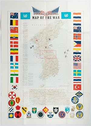
Verlag: Stars and Stripes., [Washington, D.C.]., 1953
Anbieter: Asia Bookroom ANZAAB/ILAB, Canberra, ACT, AustralienAsia Bookroom ANZAAB/ILAB
Verkäufer/-in kontaktierenVerkäufer/-in mit 5 SternenZustand: Gebraucht
EUR 426,37
EUR 18,61 VersandVersand von Australien nach USAAnzahl: 1 verfügbar
In den Warenkorb78 x 63cm. Edges trifle worn with few small closed tears, mended on reverse, overall a very good copy of a scarce map printed in Japan. A map of the Korean Peninsula marking 25 notable engagements dating from the outbreak of hostilities in June 1950 until June 1952. The map is encircled by two UN flags, the national flags of twe…nty-two nations supporting UN Command either militarily or through medical support, as well as the insignia of combatant American units.

- Karte
Anbieter: Geographicus Rare Antique Maps, Brooklyn, NY, USAGeographicus Rare Antique Maps
Verkäufer/-in kontaktierenVerkäufer/-in mit 4 SternenZustand: Gebraucht
EUR 1.212,64
EUR 14,89 VersandVersand innerhalb von USAAnzahl: 1 verfügbar
In den WarenkorbGood. Wear on old fold lines. A few edge mends. Closed tear, repaired on verso, just to left of skeleton's elbow. Italian tax stamp bottom center. Size 39 x 27 Inches. This is a powerful Italian anti-Communist Cold War propaganda poster printed c. 1953 by Gros-Monti. Referencing the Korean War, the poster emphasizes the Communis…t threat to (Western) Europe and the specter of a Korean-style conflict on the continent. It was most likely intended to bolster anti-Communist political parties in the run-up to Italy's 1953 general election. A Closer Look This haunting poster presents a map of Europe and the Near East, centered roughly on Italy. At right, a skeleton's arm labeled 'Korea' holds a tattered Communist banner. At the bottom, in large letters, is the phrase 'Their Peace.' Although undated, the poster was likely produced during the long Korean War armistice negotiations (July 1951 - July 1953). As the armistice negotiations were concluding, Italy held its first general election in five years (discussed below), and this poster was mostly likely issued at this time to support the Christian Democrats and other anti-Communist parties. Korea and the Risk of a European War As the Second World War drew to a close and early tensions began to arise between the wartime Allies, considerable effort was made, particularly with the July - August 1945 Potsdam Conference, to jockey for position but also avoid a situation that could lead to another war in the future; the Soviets and Europeans were exhausted by the war against Germany and Stalin was confident that a confrontation with capitalism could wait until the Soviets had recovered. The division of Germany into occupation zones and the shifting of borders in Eastern Europe were the major agenda items at Potsdam. However, some attention was given to the ongoing war in Asia, which the Soviets pledged to join three months after the conclusion of the war in Europe on August 9. Wartime discussions on the future of Korea were scant, and the lightning Soviet advance through Manchuria upon entering the Pacific War concerned Washington D.C. This reality led to a proposal for the division of the peninsula into occupation zones being rapidly prepared and presented to the Soviets, who unexpectedly accepted it without complaint. (The Soviets were, in fact, incapable of and uninterested in keeping a large occupation force in Korea, unlike they were Eastern European countries.) In the following months, as tensions between the Soviet Union and the West mounted, both Korea and Germany drifted towards political division along the lines of the occupation zones. While Europe remained the primary area of concern for both the Soviets and Americans, other parts of the world became proxies for the developing global rivalry. It was the misfortune of Korea to become the first intense 'hot' war of the Cold War, which left the country divided and devastated. Following a very dynamic situation in the first year of the war - with the North Koreans making rapid gains in the south, then being counter-attacked by the U.S.-led United Nations forces, then China entering the war and successfully counter-attacking the American and South Korean troops - by the summer of 1951 the war had settled into a stalemate around the original dividing line at the 38th parallel north. Armistice negotiations began in July 1951 but dragged on for months and months as neither side wanted to end the war without at least recovering their full pre-war territory. The war ground down the major outside powers engaged, the U.S. and the People's Republic of China, and became a major political liability for President Harry Truman. It is often assumed that Stalin also hoped to drag the war out to distract the U.S. from other theaters, particularly Europe; there is little direct evidence of this (Stalin generally kept his strategic calculations to himself), and Stalin was primarily concerned for the moment with avoiding the outbreak of a wider war. H.

El a kezekkel Koreatol! Vesszenek a haborús gyujtogatok! / [Hands off Korea! Get rid of the warmongers!].
1950 Hungarian Police Annex Propaganda Map of Korea, Korean War
- Karte
Anbieter: Geographicus Rare Antique Maps, Brooklyn, NY, USAGeographicus Rare Antique Maps
Verkäufer/-in kontaktierenVerkäufer/-in mit 4 SternenZustand: Gebraucht
EUR 1.212,64
EUR 14,89 VersandVersand innerhalb von USAAnzahl: 1 verfügbar
In den WarenkorbGood. On newsprint. Toning. Fold wear. Some archival verso stabilization at edges and along fragile folds. Size 16.5 x 11.5 Inches. A rare example of Cold War cartographic propaganda, this c. 1950 Hungarian-language map of Korea was prepared by the Magyar Rend?r Melléklete (Hungarian Police Annex). Meant for public display and i…nteractive coordination with news about the progress of the conflict, it extols the Korean people's struggle for 'freedom' against American 'imperialism.' A Closer Look This Hungarian-language map covers the entire Korean Peninsula (displayed as undivided, as in North Korean propaganda) along with portions of Manchuria, the Soviet Union, and Japan. Cities, towns, rail lines, provincial and national boundaries, and topographic features such as rivers are labeled throughout. The text at the top admonishes the 'warmongers' (i.e., America) and tells them to keep their 'hands off Korea.' The text at the bottom explains that the map should be publicly displayed, after which it would be turned into a sort of game where readers could track the progress of 'the freedom struggle of the Korean people' (i.e., the Korean People's Army) with small flags as they inevitably marched towards the south. It was very likely meant to be tied in with the propaganda and fundraising campaign discussed below. Hungary's Role in the Korean War Like other countries in Eastern Europe that had recently been occupied by the Soviets and fallen under Communist or Soviet-aligned governments, the Hungarian People's Republic was staunchly in support of North Korea during the Korean War, though its ability to offer material support was limited. Aside from propaganda support such as the present map, Hungary's most direct contribution to the North Koreans consisted of seven medical teams, eventually totaling over 200 doctors, nurses, and other personnel, who, between 1950 and 1957, worked in a hospital near Pyongyang (for most of this period called Rákosi Mátyás Hospital, also known as the 58th Hospital of the Korean People's Army). These personnel were not frontline military medics, though they often treated wounded soldiers and civilian victims of such aerial bombings (which were frequent and intense in Pyongyang). Moreover, they provided general medical services for the civilian population of North Korea and trained Korean medical professionals. The medical mission was perhaps more important for the new Hungarian government than the North Koreans; a fundraising drive and propaganda campaign reinforced messages of international Socialist solidarity and 'anti-imperialism,' echoing the Hungarian Working People's Party (later the Hungarian Socialist Workers' Party) own domestic propaganda and signaling the 'party line' under the rule of Mátyás Rákosi, who the previous year (1949) had moved the country towards a totalitarian dictatorship on the Stalinist model. Publication History and Census This map was prepared by the Magyar Rend?r Melléklete (Hungarian Police Annex). It is undated but likely was produced in the early phase of the conflict in 1950. We have not been able to locate another example of this map. However, the OCLC (909015096) does note two examples, held in Hungary, of a short book of the same title written by female journalist Júlia Kenyeres (1895 - 1958), published by Szikra (Spark), the newspaper of the SZIT (Trade Union Youth Worker and Apprentice Movement). It is unclear if a version of this map also appeared in that work, but the present map looks to be unlikely to have come from Kenyeres' book given its ephemeral nature, having been printed on newsprint.


