Gesamtpreis (1 Artikel Artikel):
Versandziel:

cluverius (59 Ergebnisse)
Direkt zu den wichtigsten Suchergebnissen
Suchfilter
Produktart
- Alle Product Types
- Bücher (22)
- Magazine & Zeitschriften (Keine weiteren Ergebnisse entsprechen dieser Verfeinerung)
- Comics (Keine weiteren Ergebnisse entsprechen dieser Verfeinerung)
- Noten (Keine weiteren Ergebnisse entsprechen dieser Verfeinerung)
- Kunst, Grafik & Poster (1)
- Fotografien (Keine weiteren Ergebnisse entsprechen dieser Verfeinerung)
- Karten (36)
- Manuskripte & Papierantiquitäten (Keine weiteren Ergebnisse entsprechen dieser Verfeinerung)
Zustand Mehr dazu
- Neu (Keine weiteren Ergebnisse entsprechen dieser Verfeinerung)
- Wie Neu, Sehr Gut oder Gut Bis Sehr Gut (2)
- Gut oder Befriedigend (6)
- Ausreichend oder Schlecht (Keine weiteren Ergebnisse entsprechen dieser Verfeinerung)
- Wie beschrieben (51)
Einband
Weitere Eigenschaften
- Erstausgabe (5)
- Signiert (Keine weiteren Ergebnisse entsprechen dieser Verfeinerung)
- Schutzumschlag (Keine weiteren Ergebnisse entsprechen dieser Verfeinerung)
- Angebotsfoto (38)
Sprache (5)
Gratisversand
Land des Verkäufers
Verkäuferbewertung
-

American virtues values trium
Sprache: Englisch
Verlag: Publications International, 1996
ISBN 10: 0785317740 ISBN 13: 9780785317746
Anbieter: World of Books (was SecondSale), Montgomery, IL, USA
Verkäuferbewertung 5 von 5 Sternen

Zustand: Good. Item in good condition. Textbooks may not include supplemental items i.e. CDs, access codes etc.
-

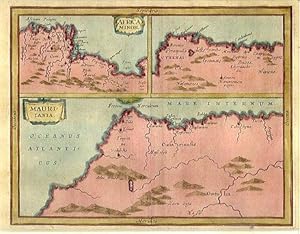
Africa Minor - Cyrenaica - Mauritania. Karte aus: Introductio in Universam Geographiam
Verlag: o.J. um 1660, 1660
Anbieter: Versandantiquariat Hösl, Neuried, Deutschland
Verkäuferbewertung 5 von 5 Sternen
Karte
Zustand: Befriedigend. Karte aus Clüvers Werk 'Introductio in Universam Geographiam' ohne Jahr, um 1660. Dreigeteilte Darstellung mit der Tunesischen Küste, der Cyrenaica und der Hauptkarte Mauretanien. Die Karte ist mittig gefaltet, am linken Rand mit Knickspuren und einem starken Flüssigkeitsfleck am oberen Eck rechts. Sprache / Language: la 1 Seiten. ca. 17,1 x 20,6 cm.
-
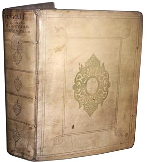
Germaniae antiquae libri tres.Editio secunda, aucta, et recognita.
Sprache: Englisch
Verlag: Ex officina Elzeviriana (Elzevir), Lugduni Batavorum (Leipzig), 1631
Anbieter: Daniel Zachariah, Buenos Aires, Argentinien
Verbandsmitglied: ALADA
Verkäuferbewertung 5 von 5 Sternen
EUR 1.624,44
EUR 20,15 Versand
Versand von Argentinien nach USAAnzahl: 1 verfügbar
In den WarenkorbHardcover. Zustand: Good. No Jacket. 748/16 pp. 26 engravings, 11 maps, engraved frontispiece, engraved title page. Vellum binding, it appears there were once tassles. Large chips from the spine, cracked hinges. The majority of the pages are very good - a few are lightly toned, some more heavily and a little fragile, some spots of foxing in places, nothing severe. There are some small tears in some pages, only one affects test/image: - p129, small piece missing from the bottom margin - figure 15 (the first after p304) has a hole in the top margin - 4cm tear from the bottom of the map SCALDIS MOSAE - p347, tear in the bottom corner - p423, 5cm tear in the right-hand margin - in the map ANTIQUAE GERMANIAE SEPTEMTRI there is a 7cm tear from the right that affects the map. - p583, 5cm tear from the bottom - in p3 of the index 4cm piece missing A decent copy of an important work, sensible price. Text in Latin. The Book Cellar & Henschel, Buenos Aires.
-
Philippi Cluverii Introductio in universam geographiam tam veterem quam novam. Tabulis geographicis XLVI ac notis olim ornata a Johanne Bunone, jam vero locupletata additamentis & annotationibus Joh. Frid. Hekelii & Joh. Reiskii. Cum privilegio ordinum Ho
Sprache: Französisch
Verlag: Jean Wolters, Amsterdam, 1697
Anbieter: Des livres autour (Julien Mannoni), Paris, PARIS, Frankreich
Verkäuferbewertung 4 von 5 Sternen

Erstausgabe
Plein Vélin. Zustand: Bon. First Thus. Amsterdam [Amstelaedami], Jean Wolters [Joannem Wolters], 1697. 24 x 18 cm (R), in-4, 1 f. bl. - titre frontispice entičrement gravé - 11 ff. n. ch. (dont titre, dédicace, adresse au lecteur, epistolae, table et privilčge) - 565 pp. - 31 ff. n. ch. d'index - 2 ff. bl. - 2 planches, 3 tableaux et 41 (sur 43) cartes gravées hors texte, dont 40 sont dépliantes ou ŕ double page, reliure hollandaise de l'époque en plein vélin doré, plats estampés ŕ froid de motifs des Pays Bas espagnols dans un double encadrement de filets avec fleurons d'angle, dos estampé de filets et fleurons, titre manuscrit ŕ l'époque, traces de lacets. (sig. *3, **4, ***4, A-Z4, Aa-Zz4, Aaa-Zzz4, Aaaa-Kkkk4) Belle édition de la fin du XVIIeme du célčbre atlas de Clüver, avec les commentaires de Buno, Reiske et Heckel, intéressante notamment parce qu'elle est au format in-4 et non in-8 ou in-12, comme la plupart des autres. Un bel ex-dono, daté de 1725 et couvrant tout le premier feuillet blanc, nous indique qu'il s'agit d'un livre de prix. Cachets annulés d'une bibliothčque de capucins au titre. Sans la mappemonde et la carte l'Amérique. Exemplaire trčs légčrement déréglé, ce qui est courant pour un volume de cette taille, une carte détachée, pour le reste un fort bel exemplaire exempt de rousseurs et dans une belle reliure estampée de l'époque. dv.
-
![Bild des Verkäufers für [VIRGINIA] [RICHMOND] CLUVERIUS. MY LIFE, TRIAL AND CONVICTION zum Verkauf von BLACK SWAN BOOKS, INC., ABAA, ILAB](https://pictures.abebooks.com/inventory/md/md30233819527.jpg)
[VIRGINIA] [RICHMOND] CLUVERIUS. MY LIFE, TRIAL AND CONVICTION
Verlag: S. J. Dudley, Richmond, VA, 1887
Anbieter: BLACK SWAN BOOKS, INC., ABAA, ILAB, Richmond, VA, USA
Verbandsmitglied: ABAA ESA ILAB
Verkäuferbewertung 5 von 5 Sternen
Original Wrappers. Zustand: Good binding. Second Edition, Enlarged. An interesting and rather compelling, account by Thomas Cluverius, who was convicted of murder and executed in Richmond in 1887. The victim was his cousin -- she was eight months pregnant and Cluverius was the father. To call the case sensational would be an understatement. This Second Edition, published the same year as the first, was enlarged to include an account of Cluverius' execution. Lacking the rear wrapper, with the front chipped and stained; the text is complete. (Haynes 3620). Good binding.
-
Africa Minor. / Mauritania.
Verlag: c., 1711
Anbieter: Robert Frew Ltd. ABA ILAB, London, Vereinigtes Königreich
Verbandsmitglied: ABA ILAB PBFA
Verkäuferbewertung 5 von 5 Sternen
Karte
EUR 71,75
EUR 11,61 Versand
Versand von Vereinigtes Königreich nach USAAnzahl: 1 verfügbar
In den Warenkorb15.5 x 18.7 cm. Full colour. Three historical maps on one double page sheet. The main panel showing what is now Morocco and part of Algeria. Above this two maps showing the continuation of the Mediterranean coastline of Africa. Good condition.
-
Introductionis in Universam Geographiam tam veterem, quam novam libri sex illustrati et aucti. et P. Bertii Breviarium.
Verlag: Typ. Seminarii,, Patavii,, 1795
Anbieter: Studio Bibliografico Benacense, Riva del garda, TN, Italien
Verkäuferbewertung 5 von 5 Sternen
Cm. 15,5, pp. 348 (10) 50 (6). Con una tavola incisa in rame e ripiegata f.t. e 3 tavole sinottiche ripiegate. Legatura coeva in piena pergamena rigida con titoli al dorso. Esemplare in perfetto stato di conservazione. Il breviario del Berti appare in fine, con numerazione autonoma. Non comune edizione padovana di questo classico della letteratura geografica.
-
Philippi Cluverii Introductionis in Universam Geographiam tam Veterem quam Novam Libri VI. Tabulis aeneis illustrati. Accessit P. Bertii Breviarium Orbis Terrarum
Verlag: Amstelodami [Amsterdam]: Ex Officina Elzeviriana [Daniel Elzevir] 1661, 1661
Anbieter: Antikvariat Valentinska, Praha, Tschechien
Verbandsmitglied: ILAB
Verkäuferbewertung 5 von 5 Sternen
One of the later editions of the "Introduction to Universal Geography", the first comprehensive modern geography, originally published in 1624-1629; it remained a standard work through the mid-18th century; the first of its six parts deals in general with the Earth, the remaining five contain short descriptions of countries and stress human and historical considerations. Written by Philipp Clüver (1580-1622), a Leiden-based German geographer, the founder of historical geography. This edition is supplemented with "Breviarium Totius Orbis Terrarum" and a survey of Roman emperors (short works by Petrus Bertius), followed by an index. The book features an engraved title page with putti and three figures of geographers. The copy contains a set of 4 fold-out plates (tables, diagrams) and 37 fold-out maps (copper engravings), both historical and modern, e.g. hemispheres, Europe, historical Roman provinces, Britain and Ireland, various European countries, various parts of Italy, Russia, Asia, China, India, Persia, Africa, America, various parts of the Middle East etc. Only a map of Galia is missing (torn away). Antiqua typeface; pages are decorated with headpieces and initials. The front endpaper and title leaf contain several ownership notes. /// Parchment binding (with handwritten title); hardback, [12]+388+[6]+[70] pp., 4 plates + 37 maps, 12° (7.5 x 13.5 cm), parchment discoloured and slightly worn, top edge darkened, fore edge with small ink stain, back hinge split, front free endpaper partly glued to front board, first plate with loss along bottom edge (diagram and text slightly corrupted), most pages, plates and maps with small narrow water stain along top edge, several maps with tear on folds, one map backed with small pieces of paper, one leaf's corner torn away (text slightly corrupted), last leaf partly detached, several leaves slightly worn along edges, other signs of wear and age are rare (minor creases and tears, small ink stain), one map missing, condition: good Book Language/s: Latin.
-
PHILIPPI CLUVERI INTRODUCTIONIS IN UNIVERSAM GEOGRAPHIAM, TAM VETEREM QUAM NOVAM. LIBRI VI; TABULIS AENEIS ILLUSTRATI. ACCESSIT P. BERTII BREVIARIUM TOTIUS ORBIS TERRARUM
Verlag: Guilielmum Broedelet, Rhenum, 1701
Anbieter: Second Story Books, ABAA, Rockville, MD, USA
Verkäuferbewertung 4 von 5 Sternen
Hardcover. 12mo; [12], 355, [83] pp. Original vellum. With engraved title page and 39 folding plates. VG; vellum discolored and age-toned, with some rubbing; interior clean and tight; all plates intact and crisp; MH Consignment; shelved case 3. 1335529. Shelved Dupont Bookstore.
-
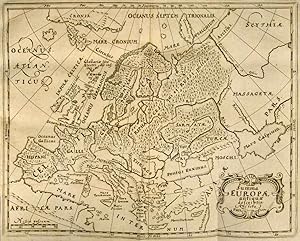
Germania antiqua. Cum vindelicia et Norico auctoris methodo, verbis & tabulis Geogr. retentis contracta opera Johannis Bunonis acc. index rerum.
Verlag: Gvelferbyti Sumtibus Conradi Bunonis, Typis Johan. Henr. Dunckeri, (Wolfenbüttel, C. Buno), 1663, 1663
Anbieter: Harteveld Rare Books Ltd., Marly, Schweiz
Verkäuferbewertung 4 von 5 Sternen
in-4to, 34 Bl. + 752 S. + 59 Bl. (Index). Mit 6 (5 gefalt.) Kupfertafeln und 10 gefalt. Karten, Original-Lederband d. Zt. (Bezug etwas brüchig, mit kl. Fehlstellen, etwas best.). Kompendium germanischer Frühgeschichte. Cluver gilt als der Vater der historischen Geographie. - Etwas gebräunt, leicht stockfleckig, Vors. leimschattig. Mit Karten von Deutschland, der Schweiz, Skandinavien usw. und Tafeln, die das Leben der alten Germanen darstellen. Exemplar ohne den gest. Titelblatt. Please notify before visiting to see a book. Prices are excl. VAT/TVA (only Switzerland) & postage. Vgl. Graesse 11, 204.
-

Introductio in universam Geographiam . Tabulis geographicis XLVI ac notis ornata a Johanne Bunone.
Verlag: London: M. Jenour für J. Nicholson ,, 1711
Anbieter: Antiquariat Ruthild Jäger, Lueneburg, Deutschland
Verkäuferbewertung 3 von 5 Sternen

4°. 1 Blatt (17 x 23 cm). Schmaler Rand, etwas gebräunt, sonst gut erhalten / slight browned, small margins, otherise in good state of conservation. * Titelblatt zu dem damals beliebten, seit 1697 mehrfach aufgelegten Geographie-Lehrbuch von Philipp Cluver, in der Londoner Ausgabe von J. Buno. Hier als Doppelblatt: rechts das Titelblatt, links das dekorative allegorische Kupferstich-Frontispiz (B. Lens sen. sc.) mit Allegorien auf die vier Weltteile.
-

Philippi Cluverii Introductionis in Universam Geographiam tam veterem, quam novam libri sex. Illustrati , & Aucti et P. Bertii, Breviarium.
Sprache: Latein
Verlag: Patavii, ex typographia Seminaarii, 1695
Anbieter: Antiquariat Deinbacher, Murstetten, Österreich
Verkäuferbewertung 5 von 5 Sternen
8° , Hardcover/Pappeinband. Titel, 4 Bl.,348 Seiten, 4 Bl. mit einer mehrfach gefaltetne Tafel und zwei Tabellen, Einband berieben, Bindung gelockert, keine losen Bögen, unbeschnitten, innen guter und sauberer Zustand. ------------------------------------------------ Philipp Clüver (auch Klüwer, häufig latinisiert als Philippus Cluverius; * 1580 in Danzig; 31. Dezember 1622 in Leiden, Niederlande) war ein deutscher Geograph und Historiker, der starken Einfluss auf die Wiederbelebung der geographischen Wissenschaft in Europa hatte, und als Begründer der historischen Geographie gilt. Clüver näherte sich der Geographie über die Geschichte und die klassischen Autoren. Zu seinen bedeutendsten Werken gehört die Introductio in Universam Geographiam (Einführung in die universelle Geographie) von 1624. Der erste von sechs Bänden befasst sich im Allgemeinen mit der Erde, aber sein Ruhm begründet sich mehr auf die übrigen fünf Bände. Sie enthalten kurze Beschreibungen der Länder, mit Schwerpunkt auf einer menschlichen und historischen Betrachtung. Diese Introductio blieb bis zur Mitte des 18.Jahrhunderts ein Standardwerk der Geographie. la Gewicht in Gramm: 550.
-
Cluverius: My Life, Trial and Conviction
Erscheinungsdatum: 1887
Anbieter: The Lawbook Exchange, Ltd., ABAA ILAB, Clark, NJ, USA
Verbandsmitglied: ABAA ESA ILAB
Verkäuferbewertung 5 von 5 Sternen
Erstausgabe
First Edition. Cluverius Tells His Story: McDade 193 Cluverius, Thomas J. [1861-1887]. Cluverius: My Life, Trial and Conviction. Richmond: Andrews, Baptist & Clemmitt, 1887. 112 pp. Quarto (6" x 5"). Stapled pamphlet in printed wrappers. Moderate soiling, spine ends abraded, chips to edges and corners of wrappers, front wrapper partially detached but secure, moderate toning to interior. $200. * First edition. A second edition with an account of the author's execution was published the same year. According to McDade, "Cluverius came from one of the 'better' Virginia families. He had married Lillian Madison, a country girl, but had kept the marriage a secret from his family and friends. He finally had her come to Richmond, where he murdered her and threw her body into the reservoir. He was quickly traced, tried, and executed." McDade, The Annals of Murder 193.
-

Cluverius: My Life, Trial and Conviction
Erscheinungsdatum: 1887
Anbieter: The Lawbook Exchange, Ltd., ABAA ILAB, Clark, NJ, USA
Verbandsmitglied: ABAA ESA ILAB
Verkäuferbewertung 5 von 5 Sternen
Erstausgabe
First Edition. Cluverius Tells His Story: McDade 193 Cluverius, Thomas J. [1861-1887]. Cluverius: My Life, Trial and Conviction. Richmond: Andrews, Baptist & Clemmitt, 1887. 112 pp. Quarto (6" x 5"). Stapled pamphlet in printed wrappers. Moderate soiling, light rubbing to extremities, spine ends abraded, moderate toning to text, minor stains to title page. $250. * First edition. A second edition with an account of the author's execution was published the same year. "Cluverius came from one of the 'better' Virginia families. He had married Lillian Madison, a country girl, but ad kept the marriage a secret from his family and friends. He finally had her come to Richmond, where he murdered her and threw her body into the reservoir. He was quickly traced, tried, and executed.": McDade, The Annals of Murder 193.
-

Helvetia conterminarumq. terrarum antiqua descriptio
Verlag: Braunschweig, 1678
Anbieter: Libreria Ex Libris ALAI-ILAB/LILA member, Roma, RM, Italien
Verkäuferbewertung 5 von 5 Sternen
Karte
Incisione originale su rame (cm. 25,5x20,5 piů ampi margini bianchi). Ottimo esemplare.
-
Chersonesi quae hodie Natolia descriptio
Verlag: Braunschweig, 1678
Anbieter: Libreria Ex Libris ALAI-ILAB/LILA member, Roma, RM, Italien
Verkäuferbewertung 5 von 5 Sternen
Karte
Incisione originale su rame (cm. 25,5x21 piů ampi margini bianchi). Ottimo esemplare.
-
Daciarum, Moesiarum et Thraciae vetus et nova descriptio
Verlag: Braunschweig, 1678
Anbieter: Libreria Ex Libris ALAI-ILAB/LILA member, Roma, RM, Italien
Verkäuferbewertung 5 von 5 Sternen
Karte
Incisione originale su rame (cm. 25x21 piů ampi margini bianchi). Ottimo esemplare.
-
Hodiernae Belgicae sive Germaniae Inferioris tabula
Verlag: Braunschweig, 1678
Anbieter: Libreria Ex Libris ALAI-ILAB/LILA member, Roma, RM, Italien
Verkäuferbewertung 5 von 5 Sternen
Karte
Incisione originale su rame (cm. 25,5x21 piů ampi margini bianchi). Ottimo esemplare.
-
Sarmatia et Scythia, Russia et Tartaria Europaea
Verlag: Braunschweig, 1678
Anbieter: Libreria Ex Libris ALAI-ILAB/LILA member, Roma, RM, Italien
Verkäuferbewertung 5 von 5 Sternen
Karte
Incisione originale su rame (cm. 25,5x24 piů ampi margini bianchi). Ottimo esemplare.
-
Scythia et Tartaria Asiatica
Verlag: Braunschweig, 1678
Anbieter: Libreria Ex Libris ALAI-ILAB/LILA member, Roma, RM, Italien
Verkäuferbewertung 5 von 5 Sternen
Karte
Incisione originale su rame (cm. 25,5x21 piů ampi margini bianchi). Ottimo esemplare.
-
Vindeliciae et Norici, conterminarumq. terrarum antiqua descriptio
Verlag: Braunschweig, 1678
Anbieter: Libreria Ex Libris ALAI-ILAB/LILA member, Roma, RM, Italien
Verkäuferbewertung 5 von 5 Sternen
Karte
Incisione originale su rame (cm. 25,5x20,5 piů ampi margini bianchi). Ottimo esemplare.
-
Syriae sive Soriae descriptio
Verlag: Braunschweig, 1678
Anbieter: Libreria Ex Libris ALAI-ILAB/LILA member, Roma, RM, Italien
Verkäuferbewertung 5 von 5 Sternen
Karte
Incisione originale su rame (cm. 25x20,5 piů ampi margini bianchi). Ottimo esemplare.
-
Veteris et nova Pannoniae et Illyrici descriptio
Verlag: Braunschweig, 1678
Anbieter: Libreria Ex Libris ALAI-ILAB/LILA member, Roma, RM, Italien
Verkäuferbewertung 5 von 5 Sternen
Karte
Incisione originale su rame (cm. 24,5x21 piů ampi margini bianchi). Ottimo esemplare.
-
Germaniae Cisrhenanae ut inter I. Caesaris et Traiani fuit Imperia Scaldis item Mosae hac Rheni ostiorum antiqua descriptio
Verlag: Braunschweig, 1678
Anbieter: Libreria Ex Libris ALAI-ILAB/LILA member, Roma, RM, Italien
Verkäuferbewertung 5 von 5 Sternen
Karte
Incisione originale su rame (cm. 25,5x25 piů ampi margini bianchi). Ottimo esemplare.
-

Antiguo Grabado Mapa - Old Engraving Map : HISPANIAE VETERIS DES
Verlag: Amsterdam, 1682
Anbieter: LIBRERÍA MAESTRO GOZALBO, Carcaixent, V, Spanien
Verkäuferbewertung 5 von 5 Sternen
Karte
Zustand: Buen estado. 1 lámina sin enmarcar Buen estado Grabado al cobre. Amsterdam, 1682. Color. Publicado en su obra: Introductio in Universam Geographiam. Representación de la Hispania romana, decorada con imaginativa cartela para el título y cuatro naves en el Atlántico.
-
Africa antiqua et nova
Verlag: Braunschweig, 1678
Anbieter: Libreria Ex Libris ALAI-ILAB/LILA member, Roma, RM, Italien
Verkäuferbewertung 5 von 5 Sternen
Karte
Incisione originale su rame (cm. 26x22 piů ampi margini bianchi). Ottimo esemplare.
-
Indiae Orientalis et Insularum adiacentium antiqua et nova descriptio
Verlag: Braunschweig, 1678
Anbieter: Libreria Ex Libris ALAI-ILAB/LILA member, Roma, RM, Italien
Verkäuferbewertung 5 von 5 Sternen
Karte
Incisione originale su rame (cm. 26,5x22 piů ampi margini bianchi). Ottimo esemplare.
-
Nova totius Germaniae descriptio
Verlag: Braunschweig, 1678
Anbieter: Libreria Ex Libris ALAI-ILAB/LILA member, Roma, RM, Italien
Verkäuferbewertung 5 von 5 Sternen
Karte
Incisione originale su rame (cm. 33x26,5 piů ampi margini bianchi). Ottimo esemplare.
-
Svecia, Dania et Norvegia
Verlag: Braunschweig, 1678
Anbieter: Libreria Ex Libris ALAI-ILAB/LILA member, Roma, RM, Italien
Verkäuferbewertung 5 von 5 Sternen
Karte
Incisione originale su rame (cm. 26,5x21,5 piů ampi margini bianchi). Ottimo esemplare.
-
Veteris et novae Britanniae descriptio
Verlag: Braunschweig, 1678
Anbieter: Libreria Ex Libris ALAI-ILAB/LILA member, Roma, RM, Italien
Verkäuferbewertung 5 von 5 Sternen
Karte
Incisione originale su rame (cm. 26x21,5 piů ampi margini bianchi). Ottimo esemplare.