Gesamtpreis (1 Artikel Artikel):
Versandziel:

cluvier (3 Ergebnisse)
Direkt zu den wichtigsten Suchergebnissen
Suchfilter
Produktart
- Alle Product Types
- B³cher (3)
- Magazine & Zeitschriften (Keine weiteren Ergebnisse entsprechen dieser Verfeinerung)
- Comics (Keine weiteren Ergebnisse entsprechen dieser Verfeinerung)
- Noten (Keine weiteren Ergebnisse entsprechen dieser Verfeinerung)
- Kunst, Grafik & Poster (Keine weiteren Ergebnisse entsprechen dieser Verfeinerung)
- Fotografien (Keine weiteren Ergebnisse entsprechen dieser Verfeinerung)
- Karten (Keine weiteren Ergebnisse entsprechen dieser Verfeinerung)
- Manuskripte & Papierantiquitõten (Keine weiteren Ergebnisse entsprechen dieser Verfeinerung)
Zustand Mehr dazu
- Neu (Keine weiteren Ergebnisse entsprechen dieser Verfeinerung)
- Wie Neu, Sehr Gut oder Gut Bis Sehr Gut (2)
- Gut oder Befriedigend (Keine weiteren Ergebnisse entsprechen dieser Verfeinerung)
- Ausreichend oder Schlecht (Keine weiteren Ergebnisse entsprechen dieser Verfeinerung)
- Wie beschrieben (1)
Einband
- alle Einbõnde
- Hardcover (3)
- Softcover (Keine weiteren Ergebnisse entsprechen dieser Verfeinerung)
Weitere Eigenschaften
- Erstausgabe (1)
- Signiert (Keine weiteren Ergebnisse entsprechen dieser Verfeinerung)
- Schutzumschlag (Keine weiteren Ergebnisse entsprechen dieser Verfeinerung)
- Angebotsfoto (2)
Sprache (2)
Preis
- Beliebiger Preis
- Weniger als EUR 20 (Keine weiteren Ergebnisse entsprechen dieser Verfeinerung)
- EUR 20 bis EUR 45 (Keine weiteren Ergebnisse entsprechen dieser Verfeinerung)
- Mehr als EUR 45
Gratisversand
- Kostenloser Versand nach USA (Keine weiteren Ergebnisse entsprechen dieser Verfeinerung)
Land des Verkõufers
Verkõuferbewertung
-
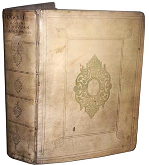
Philippi Cluverii Introductio in universam geographiam tam veterem quam novam. Tabulis geographicis XLVI ac notis olim ornata a Johanne Bunone, jam vero locupletata additamentis & annotationibus Joh. Frid. Hekelii & Joh. Reiskii. Cum privilegio ordinum Ho
Sprache: Franz÷sisch
Verlag: Jean Wolters, Amsterdam, 1697
Anbieter: Des livres autour (Julien Mannoni), Paris, PARIS, Frankreich
Verkõuferbewertung 4 von 5 Sternen

Erstausgabe
Plein Vķlin. Zustand: Bon. First Thus. Amsterdam [Amstelaedami], Jean Wolters [Joannem Wolters], 1697. 24 x 18 cm (R), in-4, 1 f. bl. - titre frontispice entiĶrement gravķ - 11 ff. n. ch. (dont titre, dķdicace, adresse au lecteur, epistolae, table et privilĶge) - 565 pp. - 31 ff. n. ch. d'index - 2 ff. bl. - 2 planches, 3 tableaux et 41 (sur 43) cartes gravķes hors texte, dont 40 sont dķpliantes ou Ó double page, reliure hollandaise de l'ķpoque en plein vķlin dorķ, plats estampķs Ó froid de motifs des Pays Bas espagnols dans un double encadrement de filets avec fleurons d'angle, dos estampķ de filets et fleurons, titre manuscrit Ó l'ķpoque, traces de lacets. (sig. *3, **4, ***4, A-Z4, Aa-Zz4, Aaa-Zzz4, Aaaa-Kkkk4) Belle ķdition de la fin du XVIIeme du cķlĶbre atlas de Cl³ver, avec les commentaires de Buno, Reiske et Heckel, intķressante notamment parce qu'elle est au format in-4 et non in-8 ou in-12, comme la plupart des autres. Un bel ex-dono, datķ de 1725 et couvrant tout le premier feuillet blanc, nous indique qu'il s'agit d'un livre de prix. Cachets annulķs d'une bibliothĶque de capucins au titre. Sans la mappemonde et la carte l'Amķrique. Exemplaire trĶs lķgĶrement dķrķglķ, ce qui est courant pour un volume de cette taille, une carte dķtachķe, pour le reste un fort bel exemplaire exempt de rousseurs et dans une belle reliure estampķe de l'ķpoque. dv.
-

Introduction Ó la Gķographie Universelle tant nouvelle, qu'ancienne.
Verlag: SAUSSIER & DAVID Denis. 2nde ķdition, 1648
Couverture rigide. Zustand: bon. RO80114539: 1648. In-16. Reliķ plein cuir. Etat passable, Couv. dķfraŅchie, Dos satisfaisant, Intķrieur acceptable. 496 pages. Lettrines illustrķes en noir et blanc. Reliure plein Vķlin. Quelques passages de vers en marges. Quelques pliures sur les derniĶres pages. Reliure muette. . . . Classification Dewey : 910-Gķographie gķnķrale. Voyages.
-
Philippi Cluverii Introductionis in Universam Geographiam tam Veterem quam Novam Libri VI. Tabulis aeneis illustrati. Accessit P. Bertii Breviarium Orbis Terrarum
Verlag: Amstelodami [Amsterdam]: Ex Officina Elzeviriana [Daniel Elzevir] 1661, 1661
Anbieter: Antikvariat Valentinska, Praha, Tschechien
Verbandsmitglied: ILAB
Verkõuferbewertung 5 von 5 Sternen

One of the later editions of the "Introduction to Universal Geography", the first comprehensive modern geography, originally published in 1624-1629; it remained a standard work through the mid-18th century; the first of its six parts deals in general with the Earth, the remaining five contain short descriptions of countries and stress human and historical considerations. Written by Philipp Cl³ver (1580-1622), a Leiden-based German geographer, the founder of historical geography. This edition is supplemented with "Breviarium Totius Orbis Terrarum" and a survey of Roman emperors (short works by Petrus Bertius), followed by an index. The book features an engraved title page with putti and three figures of geographers. The copy contains a set of 4 fold-out plates (tables, diagrams) and 37 fold-out maps (copper engravings), both historical and modern, e.g. hemispheres, Europe, historical Roman provinces, Britain and Ireland, various European countries, various parts of Italy, Russia, Asia, China, India, Persia, Africa, America, various parts of the Middle East etc. Only a map of Galia is missing (torn away). Antiqua typeface; pages are decorated with headpieces and initials. The front endpaper and title leaf contain several ownership notes. /// Parchment binding (with handwritten title); hardback, [12]+388+[6]+[70] pp., 4 plates + 37 maps, 12░ (7.5 x 13.5 cm), parchment discoloured and slightly worn, top edge darkened, fore edge with small ink stain, back hinge split, front free endpaper partly glued to front board, first plate with loss along bottom edge (diagram and text slightly corrupted), most pages, plates and maps with small narrow water stain along top edge, several maps with tear on folds, one map backed with small pieces of paper, one leaf's corner torn away (text slightly corrupted), last leaf partly detached, several leaves slightly worn along edges, other signs of wear and age are rare (minor creases and tears, small ink stain), one map missing, condition: good Book Language/s: Latin.