
Gesamtpreis (1 Artikel Artikel):
Versandziel:

c engravers (34 Ergebnisse)
Direkt zu den wichtigsten Suchergebnissen
Suchfilter
Produktart
- Alle Product Types
- Bücher (19)
- Magazine & Zeitschriften (Keine weiteren Ergebnisse entsprechen dieser Verfeinerung)
- Comics (Keine weiteren Ergebnisse entsprechen dieser Verfeinerung)
- Noten (Keine weiteren Ergebnisse entsprechen dieser Verfeinerung)
- Kunst, Grafik & Poster (13)
- Fotografien (Keine weiteren Ergebnisse entsprechen dieser Verfeinerung)
- Karten (2)
- Manuskripte & Papierantiquitäten (Keine weiteren Ergebnisse entsprechen dieser Verfeinerung)
Zustand Mehr dazu
- Neu (Keine weiteren Ergebnisse entsprechen dieser Verfeinerung)
- Wie Neu, Sehr Gut oder Gut Bis Sehr Gut (Keine weiteren Ergebnisse entsprechen dieser Verfeinerung)
- Gut oder Befriedigend (19)
- Ausreichend oder Schlecht (1)
- Wie beschrieben (14)
Einband
- alle Einbände
- Hardcover (9)
- Softcover (Keine weiteren Ergebnisse entsprechen dieser Verfeinerung)
Weitere Eigenschaften
Sprache (2)
Gratisversand
- Kostenloser Versand nach USA (Keine weiteren Ergebnisse entsprechen dieser Verfeinerung)
Land des Verkäufers
Verkäuferbewertung
-

Monmouthshire
Sprache: Englisch
Verlag: Samuel Lewis, London, 1837
Anbieter: Philip Gibbons Books, Newcastle Emlyn, Vereinigtes Königreich
Verkäuferbewertung 5 von 5 Sternen

Karte
EUR 11,88
EUR 41,74 Versand
Versand von Vereinigtes Königreich nach USAAnzahl: 1 verfügbar
In den WarenkorbNo binding. Zustand: Very Good. Antiquarian map: image (plate size): 18cm wide by 24 cm high; sheet size: 21cm by 29cm, steel engraving with original outline hand-colouring. Very Good, unmarked. Originally from Lewis's "Topographical Dictionary". Pictures show this actual map. UK orders are post-free. Sent flat in a card-backed envelope.
-
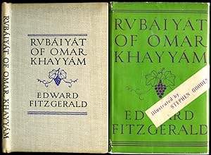
Rubáiyát of Omar Khayyám - The First Version of Edward FitzGerald | Stephen Gooden Illustrated Edition
Verlag: Published by George G. Harrap & Co. Ltd., 182 High Holborn, London Third Impression . 1947., 1947
Anbieter: Little Stour Books PBFA Member, Canterbury, Vereinigtes Königreich
Verbandsmitglied: PBFA
Verkäuferbewertung 5 von 5 Sternen
EUR 35,82
EUR 34,78 Versand
Versand von Vereinigtes Königreich nach USAAnzahl: 1 verfügbar
In den WarenkorbZustand: Very Good. Stephen Gooden illustrated hard back binding in publisher's original straw buckram covers, black title and author lettering to the spine and to the front cover. 8vo. 7˝'' x 5Ľ''. Rubáiyát over 62 pages carrying the 75 quatrains of Edward FitzGerald's version enriched with 4 mounted plates and 4 decorations by Stephen Gooden. Very Good clean condition book, in Very Good condition dust wrapper with small rubs to the spine ends and corners, not price clipped, 5/-. Gooden's work can be found in the collections of the British Museum and the Victoria and Albert Museum in London, the Fitzwilliam Museum, Cambridge and the Museum of Fine Arts, Boston, USA. Member of the P.B.F.A. Rubáiyát of Omar Khayyám.
-
Collection des Romans Grecs: Traduits en Francois, Avec des Notes par M M Courier, Larcher et autre Hellenistes; Precede d'un Essai sur les Romans Grecs par M Villemain: Five Volume Set comtaiming Tomes 1-5 and 8-15
Sprache: Englisch
Verlag: J S Merlin, Libraire, Paris, 1822
Anbieter: Silver Trees Books, Malvern, WORCS, Vereinigtes Königreich
Verkäuferbewertung 5 von 5 Sternen
EUR 597,04
EUR 24,52 Versand
Versand von Vereinigtes Königreich nach USAAnzahl: 1 verfügbar
In den WarenkorbQuarter Leather. Zustand: Very Good. Coupe et al [Engravers] after Dejuinne et al (illustrator). First Editions Thus. Five very good books in handsome quarter brown calf leather and marbled boards; title in gilt to spines.Internally very good and free of inscriptions; the contents are identical to the holding in the British Library except this set contains Tome 15 which is absent from the British Library probably because of its much later publication date. Tomes 6 & 7 are not found in either set and we cannot find any record of their publication. Text in French. Each tome has a frontispiece engraving apart from Tome 15; bindings tight; occasional scattered foxing to text pages but small and faint and never obtrusive; heavier foxing to the engraving surrounds; marbled end papers; speckled closed page edges; all tomes with one exception were published in the 1820's with the majority published in 1822-1823. Tome 15 is dated 1841. BOOK 1 contains the Essai Litteraire and Tome I Aventures d'Amour de Parthenius et Choix des Narrations de Conon; Tome II and III Amours de Theagenes et Chariclee par Heliodore [in four tomes I & II being in this book]; c + 128 + 252 + 260pp. BOOK 2 contains Tome IV Amours de Theagenes et Chariclee par Heliodore [third tome]; Tome V Amours de Theagenes et Chariclee par Heliodore fourth tome]; Tome VIII Les Pastorales de Longus 260 + 221 + 337 pp. BOOK 3 contains Tome IX Amours de Chereas et Callirrhoe [in two tomes]; Tome X Amours de Chereas et Callirrhoe [second tome]; Tome XI Habrocome et Anthia, Histoire Ephesienne 258 + 226 + 180 pp. BOOK 4 contains Tome XII La Luciade ou L'Ane de Lucius de Patras; Tome XIII Amours de Rhodanthe et Dosicles, 296 + 215 pp. BOOK 5 contains Tome XIV Aventures de Hysmine et Hysminias Tome XV Aventures de Drosilla et Charicles 323 + 368 pp A most handsome set of a very scarce publication. Photographs available on request.
-

South America: Sheet 1: Ecuador, Granada, Venezuela, and Parts of Brazil and Guayana
Verlag: Edward Stanford, 1844
Anbieter: Anybook.com, Lincoln, Vereinigtes Königreich
Verkäuferbewertung 5 von 5 Sternen
EUR 59,70
EUR 15,77 Versand
Versand von Vereinigtes Königreich nach USAAnzahl: 1 verfügbar
In den WarenkorbZustand: Fair. This is ex-library and may have the usual library/used-book markings inside. In fair condition, suitable as a study copy. Likely dated 1844. Monochrome. Approx 30 x 43.5cm. Scale in Spanish Leagues 26.2 -One Degree. And English miles 68.75 One degree. Map has been neatly cut into 9 equal sections and backed onto cloth so it may be folded easily. Some general grubbiness. There are approx. twenty small red pen underlinings of place names on map. A couple of corners are slighty worn. On reverse side of two panels blue board has been secured, and labelled with black writing within a white sticker. Small pencil marking on back of map which is also grubby. Please note the Image in this listing is a stock photo and may not match the covers of the actual item,100grams, ISBN:
-
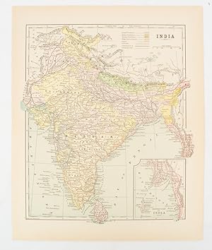
India
Verlag: [circa1910]., New York., 1910
Anbieter: Asia Bookroom ANZAAB/ILAB, Canberra, ACT, Australien
Verkäuferbewertung 5 von 5 Sternen
Printed colour map 29 x 25 cm with inset map of the Eastern Part of India, colour key reference key to the ruling divisions, current and projected railways and telegraphs also shown, central fold, slight toning; in very good condition. Interesting map shaded by Divisions: the Presidencies of Bengal, Madras, Bombay, Ceylon, "Native States under British Protection" and "Independent States" (Nepal and Bhutan).
-

India VII.
Verlag: Society for the Diffusion of Useful Knowledge; Baldwin & Cradock., London., 1832
Anbieter: Asia Bookroom ANZAAB/ILAB, Canberra, ACT, Australien
Verkäuferbewertung 5 von 5 Sternen
Handcoloured map, 28.5 x 39 cms (including platemark); 34 x 41 cms (sheet), relief throughout shown by hachures, publisher's or binder's numeric stamp (102), the margins a little browned and chipped, but in very good condition. This sheet maps a sweeping, wild, and politically fragmented area of North-Eastern and Central-Eastern India. It captures the dense, rugged interiors of Allahabad, Bahar (Bihar), Gangpoor, Sumbhulpoor, and Ruttunpoor. The sheet explicitly delineates the territories under direct East India Company British administration from those of the sovereign regional native rulers, specifically marking out the lands of the Rajah of Berar, the Rajah of Rewah, and the Bundelcund (Bundelkhand). The maritime port city of Balasore sits near the lower right-hand margin where the land meets the Bay of Bengal.
-

(TRAVELLING MAP OF) ENGLAND AND WALES.
Verlag: Charles Knight & Co. for the Society of the Diffusion of Useful Knowledge, 1848
Anbieter: Francis Edwards ABA ILAB, Hay on Wye, Vereinigtes Königreich
Verbandsmitglied: ABA ILAB PBFA
Verkäuferbewertung 5 von 5 Sternen
EUR 78,81
EUR 22,03 Versand
Versand von Vereinigtes Königreich nach USAAnzahl: 1 verfügbar
In den WarenkorbCorrected Ed. 31 x 37 inches. Linen backed folding map hand coloured in outline, dec. e.ps., folding into gilt lettered textured brown cloth boards, some scratching and sl. bubbling, rebacked in black cloth. With the signature of Flo. Fitzwygram Cap. Inniskilling Dragoons 1853. Lieutenant-General Sir Frederick Wellington John Fitzwygram, 4th Baronet DL JP (18231904) British Army cavalry officer, expert on horses and Conservative politician. A cavalry officer who served with the 6th (Inniskilling) Dragoons in the Crimean War. He subsequently commanded the Cavalry Brigade at Aldershot. US$89.
-

The Village Amanuensis.
Verlag: London: Findens' Tableaux of the Affections, circa 1843., 1843
Anbieter: Wittenborn Art Books, San Francisco, CA, USA
Verkäuferbewertung 5 von 5 Sternen
Kunst / Grafik / Poster
Zustand: Good. Engraving. 26.5 x 17.5 cm (sheet). Good, water staining in lower margin, light surface soiling.
-

India IV.
Verlag: Society for the Diffusion of Useful Knowledge; Baldwin & Cradock., London., 1832
Anbieter: Asia Bookroom ANZAAB/ILAB, Canberra, ACT, Australien
Verkäuferbewertung 5 von 5 Sternen
Handcoloured map, 29.5 x 39 cms (including platemark); 34.5 x 42 cms (sheet), relief throughout shown by hachures, publisher's or binder's stamp (99), the margins a little browned and chipped, but in very good condition. An attractive map showing Central and Eastern India, including Hyderabad, Berear and the Northern Circars. This long coastal strip along the Bay of Bengal (modern-day Andhra Pradesh and Odisha) is marked as a critical British presidency asset. The map shows its major maritime ports, like Masulipatnam and Visakhapatnam, which acted as vital economic gatekeepers connecting Central India's interior to ocean trade lines. As the official hydrographers to the East India Company, John and Charles Walker packed their maps with technical markers intended to educate the British public.
-
A collection of engravings after Jean-Baptiste Oudry.
Verlag: France: early/mid-19th Century.
Anbieter: Wittenborn Art Books, San Francisco, CA, USA
Verkäuferbewertung 5 von 5 Sternen
Kunst / Grafik / Poster
Zustand: Good. A collection of 72 engravings on China paper, illustrating La Fontaine and other writers. Contained in a qtr. cloth portfolio. Sheet size 31 x 21 cm. Platemark 17 x 11cm.
-
The American Aboriginal Portfolio. By Mrs. Mary H. Eastman. Illustrated by S. Eastman, U.S. Army. First edition.
Verlag: Philadelphia: Lippincott, Grambo, & Co., [1853], 1853
Anbieter: Wittenborn Art Books, San Francisco, CA, USA
Verkäuferbewertung 5 von 5 Sternen
Signiert
Zustand: Good. Large 4to. 23 x 31cm. Half goatskin and marbled paper boards by the artisan biner Sasha Mosalov.Plates with minor to major foxing in the margins.[iii]-v, [3], [9]-84 pp. With 26 steel-engraved plates from drawings by Seth Eastman including the frontispiece, plus steel-engraved added title; plain protective interleaves for the plates. .A series of detailed engravings after drawings by Seth Eastman, who was stationed, along with his wife Mary, at Fort Snelling, Minnesota, from 1841 through 1848. These depict such revealing aspects of Native American life as transportation of wounded, the medicine dance of the Winnebagoes, spearing fish from a canoe, an Indian woman dressing a buffalo skin, etc. Wagner-Camp cautions that the work "should not be confused with Mrs. Eastman's later work, published in 1854 as Chicora, and again as American Annual. Mrs. Eastman's Portfolio consists of twenty-six engravings from Captain Eastman's paintings of Indian life, each with a guard sheet and a short explanatory essay of two or three pages." Field 477n; Wagner-Camp 222c.; Howes E-17; Sabin 21682; Wagner-Camp-Becker 222a; OCLC Number / Unique Identifier:1870490: 84 pages, 25 unnumbered leaves of plates : illustrations, portrait ; 33 cm? Seth Eastman was a painter and soldier best known for his depictions of the everyday life of Dakota and Ojibwe people around Fort Snelling in the 1840s.OCLC Number / Unique Identifier:1870490: A selection of plates from volumes 1-3 (1851-1853) of: Schoolcraft, Henry Rowe. Historical and statistical information respecting the history, condition, and prospects of the Indian tribes of the United StatesAdded engraved title page: The American aboriginal port folio. With vignette "Engraved by Illman & Sons."Cover title: Eastman's aboriginal portfolioCollation: [1]? 2-10? [11] [$1 signed]; 42 leaves, pages [i-iii] iv-v [vi-viii (viii blank)] [9] 10-84 + 25 plates (each preceded by a bound-in guard sheet)Plates engraved by Charles K. Burt, James Smillie, John C. McRae, C.E. Wagstaff & J. Andrews, and Alfred JonesFirst plate, a portrait of Red Jacket, bound as frontispieceIssued in blue cloth, stamped in gold; all edges gilt.
-
Planches de l'iconographie grecque par le Chevalier E. Q. Visconti, membre de l'Institut de France. Original edition.
Verlag: Paris: P. Didot l'aîné, 1817
Anbieter: Wittenborn Art Books, San Francisco, CA, USA
Verkäuferbewertung 4 von 5 Sternen

Zustand: Good. Large folio. 46.5 x 62 cm. Original boards, worn but intact; lower corners with loss.Complete with 57 etched and engraved plates. Tissue guards in place and foxed ; Light to moderate foxing throughout the plates, mainly in the margins. En 1804, Napoléon Ier lui demanda de rassembler grand nombre de portraits d'hommes illustres grecs et romains pour y créer une collection. Aux frais du gouvernement, il lui fut ordonné une iconographie grecque puis romaine, qui parurent respectivement en 1808 & en 1817. Les planches ont été gravées sur cuivre, d'aprčs de nombreux artistes français et italiens, dont Laguiche, Pozzi, Tofanelli, Mauri, etc.OCLC Number: 68527874; Brunet V-1314; Quérard X-250. .In-plano (620 X 460 mm). Cartonnage d'attente du temps. (Reliure endommagée. Fortes rousseurs).Titre et 57 planches gravées sur papier vélin. Ennio-Quirino Visconti (1751-1818), diplomate et archéologue, fut tour ŕ tour sous-bibliothécaire du Vatican, bibliothécaire du Palais Chigi, conservateur du Musée du Capitole, puis, devenu Français en 1814, conservateur du Musée du Louvre.Sans le volume de l'Iconographie romaine.Expertise by Jean-Paul VEYSSIERE, libraire - expert. Membre de la LILA-ILAB;Expert CNES, assesseur prčs la commission de conciliation et d'expertise douanič.
-
Rubáiyát of Omar Khayyám - The First Version of Edward FitzGerald | Stephen Gooden Illustrated Edition [Signed]
Verlag: Published by George G. Harrap & Co. Ltd., 182 High Holborn, London First Edition Thus . 1940., 1940
Anbieter: Little Stour Books PBFA Member, Canterbury, Vereinigtes Königreich
Verbandsmitglied: PBFA
Verkäuferbewertung 5 von 5 Sternen
Erstausgabe Signiert
EUR 776,16
EUR 34,78 Versand
Versand von Vereinigtes Königreich nach USAAnzahl: 1 verfügbar
In den WarenkorbZustand: Very Good. First edition thus Stephen Gooden illustrated hard back binding in publisher's special quarter green leather binding over emerald green cloth boards, gilt title lettering to the spine, top edge gilt. 8vo. 8'' x 5˝''. Hand written number 36 of 125 Limited Edition copies SIGNED by the artist 'Stephen Gooden'. Rubáiyát over 63 pages carrying the 75 quatrains of Edward FitzGerald's version enriched with 4 full-page plates and 4 decorations by Stephen Gooden. The trade edition published in the same year contained the same plates, albeit were tipped-in and not full-page. Slight sun fading down the spine. Very Good condition book in Very Good peppermint green paper covered slip case carrying the correct limited edition number 36 for this book. Gooden's work can be found in the collections of the British Museum and the Victoria and Albert Museum in London, the Fitzwilliam Museum, Cambridge and the Museum of Fine Arts, Boston, USA. Member of the P.B.F.A. Rubáiyát of Omar Khayyám.
-

Bokhara, Afghanistan, Beloochistan, &c.
Verlag: (Society for the Diffusion of Useful Knowledge); Charles Knight, London., 1852
Anbieter: Asia Bookroom ANZAAB/ILAB, Canberra, ACT, Australien
Verkäuferbewertung 5 von 5 Sternen
Engraved map, 39 x 30.5 cms; 41 x 34 cms (sheet), relief throughout shown by hachures, publisher's or binder's numeric stamp (94A), the margins a little browned and chipped with loss to the two keys at the inner edge marking Indian and Persian distances but the map in very good condition. A highly detailed example of political and military cartography from the height of the Victorian era, capturing the Central Asian frontier at the dawn of the "Great Game". The map covers the expanse of Central Asia, stretching from the deserts of modern-day Uzbekistan and Turkmenistan down through Afghanistan and Pakistan to the Arabian Sea. It maps out the Emirate of Bukhara in the north and the Desert of Khiva. It explicitly references the "Nomadic Tribes of Turkomans" roaming the steppes. Afghanistan is centred on the map, and displays the fractured geography of the Afghan kingdom. It details the treacherous mountain passes of the Hindu Kush, alongside the major strategic cities of Kabul, Kandahar, and Herat. Beloochistan (Balochistan) & Sinde (Sindh)anchor the southern third of the sheet, it routes down toward the coastline, showing the vast desert paths, tribal domains, and the mouth of the Indus River.
-
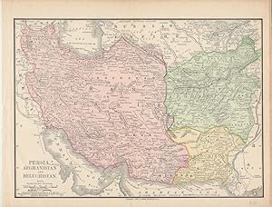
Persia, Afghanistan and Beluchistan.
Verlag: Rand McNally & Co., Chicago., 1890
Anbieter: Asia Bookroom ANZAAB/ILAB, Canberra, ACT, Australien
Verkäuferbewertung 5 von 5 Sternen
Map with original colour 18.6 x 25.9 cm, central fold, inner margin darkened and outer margin a bit worn but in very good condition. An appealing map showing Iran/Persia, Afghanistan and Beluchistan finely shaded and the borders with Turkey, India, Turkestan and the Russian Empire. Also noting that "Names referring to Ancient Geography are in Light Characters", and recording submarine telegraph cables.
-
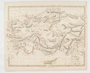
Turkey containing the provinces in Asia Minor.
Verlag: Society for the Diffusion of Useful Knowledge. Baldwin & Cradock., London., 1830
Anbieter: Asia Bookroom ANZAAB/ILAB, Canberra, ACT, Australien
Verkäuferbewertung 5 von 5 Sternen
Engraved map wth outline hand colour, 29.7 x 42 cm, relief shown in hachures, key to abbreviations, including "Ancient Ruins", the west and east extremities attactively engraved to burst through the border, original folds, map with occasional spotting, more pronounced at the lower corner, edges a little ragged, small chip to the inner margin (no loss to the map), manuscript pagination in the lower corner, but in good condition.
-

Egypt showing the Egyptian Soudan, Arabia, etc.
Verlag: Hunt & Eaton. [Circa1893]., New York., 1893
Anbieter: Asia Bookroom ANZAAB/ILAB, Canberra, ACT, Australien
Verkäuferbewertung 5 von 5 Sternen
Printed map in colour, elevation shown with hachures, 29 x 23.5 cm, text on the verso relating to entries for Afghanistan Beluchistan and Turkey, prepared for Hunt & Eaton's "New York Recorder's Atlas", small tears to the top edge, but in very good condition.
-

Firth of Forth. St. Abbs Head to the Forth Bridge.
Verlag: LondonThe Admiralty., 1921
Anbieter: Robert Frew Ltd. ABA ILAB, London, Vereinigtes Königreich
Verbandsmitglied: ABA ILAB PBFA
Verkäuferbewertung 5 von 5 Sternen
Karte
EUR 119,41
EUR 11,59 Versand
Versand von Vereinigtes Königreich nach USAAnzahl: 1 verfügbar
In den Warenkorb63.5 x 111.5 cm. Uncoloured, with principal points (light houses, etc) highighted in orange. Large folding sheet chart of the Firth of Forth. Title in red ink on verso. Some offsetting. Ink stamp to lower right corner.
-
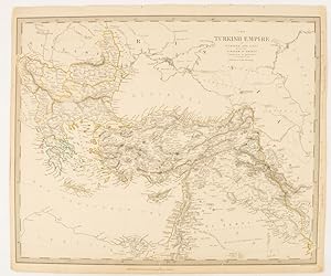
The Turkish Empire in Europe and Asia with the Kingdom of Greece.
Verlag: Charles Knight & Co. [circa1840s.], London., 1840
Anbieter: Asia Bookroom ANZAAB/ILAB, Canberra, ACT, Australien
Verkäuferbewertung 5 von 5 Sternen
Lithographed map with original outline hand-colour, 31.9 x 39.1 cm, small marginal tears neatly repaired with archival material, but no loss, small surface abrasion affecting the border at the foot, edgewear and browning, inked pagination in an early hand, but in very good condition. A handsome map with fine topographical engraving, also showing the borders with Hungary, Russia and Persia.
-

Measure for Measure Act II. Scene I. Angelo's House.
Verlag: London John and Josiah Boydell . 1803., 1798
Anbieter: Robert Frew Ltd. ABA ILAB, London, Vereinigtes Königreich
Verbandsmitglied: ABA ILAB PBFA
Verkäuferbewertung 5 von 5 Sternen
Kunst / Grafik / Poster
EUR 179,11
EUR 11,59 Versand
Versand von Vereinigtes Königreich nach USAAnzahl: 1 verfügbar
In den WarenkorbOriginal copper engraving (c. 44 x 60 cm, overall sheet 55 x 68.5 cm). Tissue guard to verso. From "A Collection of Prints . Illustrating the Dramatic Works of Shakespeare." published by Boydell, London, 1803. In 1789, the publisher John Boydell opened the Shakespeare Gallery, an exhibition space in London's Pall Mall showcasing paintings that exclusively represented scenes from Shakespeare's plays. The Gallery was a bid to revive 'history painting' (the practice of depicting scenes from the Bible, mythology or the classics) in contemporary British art, a genre thought to be of great public benefit because of its morally instructive messages. What better unifying theme for such a project than the works of Shakespeare, which had become so popular and so integral to British identity by the mid-18th century? The Gallery opened in May 1789 with 34 canvases by 18 British artists. By the next year there were 55 paintings and in 1796 the total was 84, along with dozens of 'Small Pictures'. Once the exhibition was mounted, reproductive engravings of the paintings produced by an in-house team of 46 printmakers were available to purchase, either as a large portfolio of 90 prints or as a luxurious illustrated edition of the plays. (The British Library).
-

India XII. Panjab with Part of Afghanistan, Kashmeer, Sinde &c. &c.
Verlag: Society for the Diffusion of Useful Knowledge, London., 1839
Anbieter: Asia Bookroom ANZAAB/ILAB, Canberra, ACT, Australien
Verkäuferbewertung 5 von 5 Sternen
A pair of engraved maps, 39.1 x 41.6 cms, 41.1 x 34.5 cms (sheet), sealed edge tears to the right outer margins on each sheet (without loss), the left margins have been re-enforced with washi, some age-toning, but both maps in very good condition. Highly detailed regional maps of the Northwest Frontier. Map 107 details the Five Rivers of the Punjab, Sindh, and Kashmir and Map 107 A is specialized supplemental sheet, broadening the scope to map out the rugged mountain passes, military routes, and tribal territories of Afghanistan stretching toward Kabul and Kandahar, part of a regional survey published by SDUK. Strategically important maps published at the outbreak of the First Anglo-Afghan War and in the wake of regional border struggles marking the Great Game.
-
Suite de vingt-quatre vues de jardins anglais exécutés par [Louis-Martin] Berthault. Architecte de L'Empereur et Roi . First edition of the aquatints.
Verlag: Paris : Chez Basset, rue St. Jacques, no. 64, circa 1812-, 1812
Anbieter: Wittenborn Art Books, San Francisco, CA, USA
Verkäuferbewertung 4 von 5 Sternen
Kunst / Grafik / Poster
Zustand: Good. Suite complčte de 24 planches gravées par Pierre-Gabriel Berthault d'aprčs 24 aquatints and soft ground etchings, title page 29 x 21.5cm; others oblong.OCLC Number / Unique Identifier:3723722.); Louis-Martin Berthault (1770?1823) : French architect and landscape-architect, a pupil of Percier. He decorated a house on the Rue du Mont-Blanc, Paris, and designed a celebrated garden at Raincy which included a Russian House, a grotto, and an iron bridge (all 1790s and early 1800s). His garden at Les Fontaines, near Chantilly (1792-1822), had Picturesque and Neo-Classical features (e.g. Fisherman's House, Boat-House, Sepulchre, and Obelisk on an island), and is known from the drawings by C. Bourgeois and Berthault's uncle, Pierre-Gabriel Berthault, published in Suite de Vingt-Quatre Vues de Jardins Anglais (1812). Berthault transformed several French gardens into less formal arrangements, notably at Courson (from 1820). He became Chief Architect to the Empress Josephine (1763-1814) in 1805, for whom he carried out works at the garden of La Malmaison. Other parks on which he worked were those at St-Leu-Taverny, Beauregard (near Villeneuve-St-George), and Compičgne. His eclectic use of a wide variety of exotic shrubs and trees created a rich, sometimes overwhelming effect.British Museum: Paul André Basset, artist and publisher.Address: (by mid 1812) rue Saint Jacques no.64 (which was still the building at the corner of the Mathurins), where firm remained at least to 1885 (see Beraldi I p.104.)Biography:. Paris print publisher, printseller and wallpaper manufacturer, son of André. Married in 1787. Premises at the corner of rue St Jacques and rue des Mathurins. Very active during the revolutionary period . Retired in 1819; business continued by various members of the family at same address before disappearing after 1865 (see Nouvelles de l'Estampe 176 (2001) p.6, note 11). The family were major publishers, with 1425 entries in the BdlF between 1799 and 1852. The firm aimed at the middle parket, and only published social satires, never political caricatures.Some plates were taken over from Martinet. Basset publications are sometimes found with running numbers at top right, which presumably refer to a catalogue.Expertise by : : Jean Lequoy Librairie Giraud-Badin 22, rue Guynemer - 75006 Paris.
-

The River Euphrates from Abu' Saide to Werdi.From The Expedition for the Survey of the Euphrates and Tigris, 1836-1840. First edition of the map.
Verlag: [London]: Colonel Chesney, 1849
Anbieter: Wittenborn Art Books, San Francisco, CA, USA
Verkäuferbewertung 4 von 5 Sternen
Kunst / Grafik / Poster
Zustand: Good. Original engraving. Map IV of XII. 50 x 62 x cm. Folding. Marginal tears.The 12 maps were printed separately by the firm of J. & C. Walker, who was the official printer for the British Admiralty and the East India Company. They were published by Colonel Chesney himself in 1849. They were more commonly issued along with Chesney's text volumes, "The Expedition for The Survey of The Rivers Euphrates and Tigris, Carried on by Order of The British Gov. , "published by Longman, Brown, Green, and Longmans, London, 1850.OCLC Number / Unique Identifier:316378697 for the complete set.The Euphrates expedition of 1836 was lead by the British army officer Colonel Francis Rawson Chesney. The main objective was to establish a route "between the Mediterranean Sea and His Majesty's possessions in the East Indies by means of a steam communication of the river Euphrates". Finding a shorter route to India was the hot topic of the time. The East India Company sought a suitable solution to cut down the travel time between England and India. Chesney was involved in initial surveys in Egypt and the Middle East in the late 1820s where he investigated the possibility of passage to India via the Red Sea. In 1829 he submitted a report advocating the construction of the Suez Canal. He also brought to attention the feasibility of steam communication with India through the Euphrates. The king William IV himself expressed a desire that the route by the Euphrates to India should be put to a practical test.In late 1834 when Chesney received funds for the expedition he assembled a capable group of naval and military officers including the explorer Henry Blosse Lynch of the Indian Navy and a geologist William Francis Ainsworth, president of the Royal Physical Society of Edinburgh. He also selected workmen from the Royal Artillery, Royal Sappers and Miners qualified in steam machinery, surveying and drawing. Chesney returned to England in September 1832 after surveying the lower Euphrates by raft and was convinced that the river was navigable, providing a swift route to India. He also believed a British presence in Mesopotamia would discourage Russian encroachment. Chesney had a well-publicised interview with William IV in April 1833, who became an avid supporter of the Euphrates scheme. Petitioning led to the nomination of a select committee which in June 1834 supported an exploratory expedition with the backing of Ł20,000. Chesney was given the temporary rank of Colonel and lead fourteen officers and thirty-nine men on the mission.On 10th February 1835 they sailed for Syria. The two steamships, 'Euphrates' and 'Tigris', had to be tugged in sections over fifty miles of difficult terrain, the Arab tribes along the route were hostile and many of the men, including Chesney, suffered from malaria. On 21st May 1836 a sudden storm hit and the 'Tigris' was wrecked with the loss of twenty lives. . Chesney managed, with the remaining boat, to explore and chart the Euphrates, the Tigris and the Karum rivers. This exploration ended in India and he returned to London in August 1837. This accomplishment won him the admiration of geographers and he was awarded the Geographical Society's gold medal. .After preparing an account of the expedition, Chesney returned to regimental duty in 1841 and by 1843 had risen in rank being appointed Commandant of Hong Kong. In 1847 Chesney returned to England; his last military appointment was as Colonel Commandant of the Cork district, after which he retired to his home at Pacolet, near Kilkeel, county Down, Ireland in 1852.Expertise by Elvire POULAIN &Anne Sophie JONCOUX-PILORGE, Paris.
-

The River Tigris from Nineveh to Kalah Sherakat and from Kalah Sherakat to Samarra. From The Expedition for the Survey of the Euphrates and Tigris, 1836-1840. First edition of the map.
Verlag: [London]: Colonel Chesney, 1849
Anbieter: Wittenborn Art Books, San Francisco, CA, USA
Verkäuferbewertung 4 von 5 Sternen
Kunst / Grafik / Poster
Zustand: Good. Original engraving. Map VI of XII. 61x 50cm. Folding Marginal tears.The 12 maps were printed separately by the firm of J. & C. Walker, who was the official printer for the British Admiralty and the East India Company. They were published by Colonel Chesney himself in 1849. They were more commonly issued along with Chesney's text volumes, "The Expedition for The Survey of The Rivers Euphrates and Tigris, Carried on by Order of The British Gov." published by ongman, Brown, Green, and Longmans, London, 1850.OCLC Number / Unique Identifier:316378697 for the complete set.The Euphrates expedition of 1836 was lead by the British army officer Colonel Francis Rawson Chesney. The main objective was to establish a route "between the Mediterranean Sea and His Majesty's possessions in the East Indies by means of a steam communication of the river Euphrates". Finding a shorter route to India was the hot topic of the time. The East India Company sought a suitable solution to cut down the travel time between England and India. Chesney was involved in initial surveys in Egypt and the Middle East in the late 1820s where he investigated the possibility of passage to India via the Red Sea. In 1829 he submitted a report advocating the construction of the Suez Canal. He also brought to attention the feasibility of steam communication with India through the Euphrates. The king William IV himself expressed a desire that the route by the Euphrates to India should be put to a practical test. In late 1834 when Chesney received funds for the expedition he assembled a capable group of naval and military officers including the explorer Henry Blosse Lynch of the Indian Navy and a geologist William Francis Ainsworth, president of the Royal Physical Society of Edinburgh. He also selected workmen from the Royal Artillery, Royal Sappers and Miners qualified in steam machinery, surveying and drawing. Chesney returned to England in September 1832 after surveying the lower Euphrates by raft and was convinced that the river was navigable, providing a swift route to India. He also believed a British presence in Mesopotamia would discourage Russian encroachment. Chesney had a well-publicised interview with William IV in April 1833, who became an avid supporter of the Euphrates scheme. Petitioning led to the nomination of a select committee which in June 1834 supported an exploratory expedition with the backing of Ł20,000. Chesney was given the temporary rank of Colonel and lead fourteen officers and thirty-nine men on the mission.On 10th February 1835 they sailed for Syria. The two steamships, 'Euphrates' and 'Tigris', had to be tugged in sections over fifty miles of difficult terrain, the Arab tribes along the route were hostile and many of the men, including Chesney, suffered from malaria. On 21st May 1836 a sudden storm hit and the 'Tigris' was wrecked with the loss of twenty lives. Chesney managed, with the remaining boat, to explore and chart the Euphrates, the Tigris and the Karum rivers. This exploration ended in India and he returned to London in August 1837. This accomplishment won him the admiration of geographers and he was awarded the Geographical Society's gold medal. .After preparing an account of the expedition, Chesney returned to regimental duty in 1841 and by 1843 had risen in rank being appointed Commandant of Hong Kong. In 1847 Chesney returned to England; his last military appointment was as Colonel Commandant of the Cork district, after which he retired to his home at Pacolet, near Kilkeel, county Down, Ireland in 1852.Expertise by Elvire POULAIN &Anne Sophie JONCOUX-PILORGE, Paris.
-

The River Euphrates from Ummu-L-Huntah to Ku'rnah with the River Tigris from Serut Castle to Kurnah and the Shatt el 'Arabfrom Kurnah Basrah. From The Expedition for the Survey of the Euphrates and Tigris, 1836-1840. First edition of the map.
Verlag: [London]: Colonel Chesney, 1849
Anbieter: Wittenborn Art Books, San Francisco, CA, USA
Verkäuferbewertung 4 von 5 Sternen
Kunst / Grafik / Poster
Zustand: Good. Original engraving. Map X of XII. 77 x 49.5cm. Folding. Marginal tears and stains in top margin.The 12 maps were printed separately by the firm of J. & C. Walker, who was the official printer for the British Admiralty and the East India Company . They were published by Colonel Chesney himself in 1849. They were more commonly issued along with Chesney's text volumes, "The Expedition for The Survey of The Rivers Euphrates and Tigris, Carried on by Order of The British Gov." published by ongman, Brown, Green, and Longmans, London, 1850.OCLC Number / Unique Identifier:316378697 for the complete set.The Euphrates expedition of 1836 was lead by the British army officer Colonel Francis Rawson Chesney. The main objective was to establish a route "between the Mediterranean Sea and His Majesty's possessions in the East Indies by means of a steam communication of the river Euphrates". Finding a shorter route to India was the hot topic of the time. The East India Company sought a suitable solution to cut down the travel time between England and India. Chesney was involved in initial surveys in Egypt and the Middle East in the late 1820s where he investigated the possibility of passage to India via the Red Sea. In 1829 he submitted a report advocating the construction of the Suez Canal. He also brought to attention the feasibility of steam communication with India through the Euphrates. The king William IV himself expressed a desire that the route by the Euphrates to India should be put to a practical test. In late 1834 when Chesney received funds for the expedition he assembled a capable group of naval and military officers including the explorer Henry Blosse Lynch of the Indian Navy and a geologist William Francis Ainsworth, president of the Royal Physical Society of Edinburgh. He also selected workmen from the Royal Artillery, Royal Sappers and Miners qualified in steam machinery, surveying and drawing. Chesney returned to England in September 1832 after surveying the lower Euphrates by raft and was convinced that the river was navigable, providing a swift route to India. He also believed a British presence in Mesopotamia would discourage Russian encroachment. Chesney had a well-publicised interview with William IV in April 1833, who became an avid supporter of the Euphrates scheme. Petitioning led to the nomination of a select committee which in June 1834 supported an exploratory expedition with the backing of Ł20,000. Chesney was given the temporary rank of Colonel and lead fourteen officers and thirty-nine men on the mission.On 10th February 1835 they sailed for Syria. The two steamships, 'Euphrates' and 'Tigris', had to be tugged in sections over fifty miles of difficult terrain, the Arab tribes along the route were hostile and many of the men, including Chesney, suffered from malaria. On 21st May 1836 a sudden storm hit and the 'Tigris' was wrecked with the loss of twenty lives. Chesney managed, with the remaining boat, to explore and chart the Euphrates, the Tigris and the Karum rivers. This exploration ended in India and he returned to London in August 1837. This accomplishment won him the admiration of geographers and he was awarded the Geographical Society's gold medal. .After preparing an account of the expedition, Chesney returned to regimental duty in 1841 and by 1843 had risen in rank being appointed Commandant of Hong Kong. In 1847 Chesney returned to England; his last military appointment was as Colonel Commandant of the Cork district, after which he retired to his home at Pacolet, near Kilkeel, county Down, Ireland in 1852.Expertise by Elvire POULAIN &Anne Sophie JONCOUX-PILORGE, Paris.
-

The River Euphrates from Hit to the Kuthah River and the River Tigris from Samarra to the Abu Hitti Canal from Samarra toDokhala and from Dokhala to the Abu Hitti Canal. From The Expedition for the Survey of the Euphrates and Tigris, 1836-1840. First edition of the map.
Verlag: [London]: Colonel Chesney, 1849
Anbieter: Wittenborn Art Books, San Francisco, CA, USA
Verkäuferbewertung 4 von 5 Sternen
Kunst / Grafik / Poster
Zustand: Good. Original engraving. Map VII of XII. 50 x 62.5cm. Folding. Marginal tears.The 12 maps were printed separately by the firm of J. & C. Walker, who was the official printer for the British Admiralty and the East India Company . They were published by Colonel Chesney himself in 1849. They were more commonly issued along with Chesney's text volumes, "The Expedition for The Survey of The Rivers Euphrates and Tigris, Carried on by Order of The British Gov." published by ongman, Brown, Green, and Longmans, London, 1850.OCLC Number / Unique Identifier:316378697 for the complete set.The Euphrates expedition of 1836 was lead by the British army officer Colonel Francis Rawson Chesney. The main objective was to establish a route "between the Mediterranean Sea and His Majesty's possessions in the East Indies by means of a steam communication of the river Euphrates". Finding a shorter route to India was the hot topic of the time. The East India Company sought a suitable solution to cut down the travel time between England and India. Chesney was involved in initial surveys in Egypt and the Middle East in the late 1820s where he investigated the possibility of passage to India via the Red Sea. In 1829 he submitted a report advocating the construction of the Suez Canal. He also brought to attention the feasibility of steam communication with India through the Euphrates. The king William IV himself expressed a desire that the route by the Euphrates to India should be put to a practical test. In late 1834 when Chesney received funds for the expedition he assembled a capable group of naval and military officers including the explorer Henry Blosse Lynch of the Indian Navy and a geologist William Francis Ainsworth, president of the Royal Physical Society of Edinburgh. He also selected workmen from the Royal Artillery, Royal Sappers and Miners qualified in steam machinery, surveying and drawing. Chesney returned to England in September 1832 after surveying the lower Euphrates by raft and was convinced that the river was navigable, providing a swift route to India. He also believed a British presence in Mesopotamia would discourage Russian encroachment. Chesney had a well-publicised interview with William IV in April 1833, who became an avid supporter of the Euphrates scheme. Petitioning led to the nomination of a select committee which in June 1834 supported an exploratory expedition with the backing of Ł20,000. Chesney was given the temporary rank of Colonel and lead fourteen officers and thirty-nine men on the mission.On 10th February 1835 they sailed for Syria. The two steamships, 'Euphrates' and 'Tigris', had to be tugged in sections over fifty miles of difficult terrain, the Arab tribes along the route were hostile and many of the men, including Chesney, suffered from malaria. On 21st May 1836 a sudden storm hit and the 'Tigris' was wrecked with the loss of twenty lives. Chesney managed, with the remaining boat, to explore and chart the Euphrates, the Tigris and the Karum rivers. This exploration ended in India and he returned to London in August 1837. This accomplishment won him the admiration of geographers and he was awarded the Geographical Society's gold medal. .After preparing an account of the expedition, Chesney returned to regimental duty in 1841 and by 1843 had risen in rank being appointed Commandant of Hong Kong. In 1847 Chesney returned to England; his last military appointment was as Colonel Commandant of the Cork district, after which he retired to his home at Pacolet, near Kilkeel, county Down, Ireland in 1852.Expertise by Elvire POULAIN &Anne Sophie JONCOUX-PILORGE, Paris.
-

The River Euphrates from Werdi to Hit. From The Expedition for the Survey of the Euphrates and Tigris, 1836-1840. First edition of the map.
Verlag: [London]: Colonel Chesney, 1849
Anbieter: Wittenborn Art Books, San Francisco, CA, USA
Verkäuferbewertung 4 von 5 Sternen
Kunst / Grafik / Poster
Zustand: Good. Original engraving. Map V of XII. 50.5 x 60cm. Folding. Marginal tears.The 12 maps were printed separately by the firm of J. & C. Walker, who was the official printer for the British Admiralty and the East India Company. They were published by Colonel Chesney himself in 1849. They were more commonly issued along with Chesney's text volumes, "The Expedition for The Survey of The Rivers Euphrates and Tigris, Carried on by Order of The British Gov." published by ongman, Brown, Green, and Longmans, London, 1850.OCLC Number / Unique Identifier:316378697 for the complete set.The Euphrates expedition of 1836 was lead by the British army officer Colonel Francis Rawson Chesney. The main objective was to establish a route "between the Mediterranean Sea and His Majesty's possessions in the East Indies by means of a steam communication of the river Euphrates". Finding a shorter route to India was the hot topic of the time. The East India Company sought a suitable solution to cut down the travel time between England and India. Chesney was involved in initial surveys in Egypt and the Middle East in the late 1820s where he investigated the possibility of passage to India via the Red Sea. In 1829 he submitted a report advocating the construction of the Suez Canal. He also brought to attention the feasibility of steam communication with India through the Euphrates. The king William IV himself expressed a desire that the route by the Euphrates to India should be put to a practical test. In late 1834 when Chesney received funds for the expedition he assembled a capable group of naval and military officers including the explorer Henry Blosse Lynch of the Indian Navy and a geologist William Francis Ainsworth, president of the Royal Physical Society of Edinburgh. He also selected workmen from the Royal Artillery, Royal Sappers and Miners qualified in steam machinery, surveying and drawing. Chesney returned to England in September 1832 after surveying the lower Euphrates by raft and was convinced that the river was navigable, providing a swift route to India. He also believed a British presence in Mesopotamia would discourage Russian encroachment. Chesney had a well-publicised interview with William IV in April 1833, who became an avid supporter of the Euphrates scheme. Petitioning led to the nomination of a select committee which in June 1834 supported an exploratory expedition with the backing of Ł20,000. Chesney was given the temporary rank of Colonel and lead fourteen officers and thirty-nine men on the mission.On 10th February 1835 they sailed for Syria. The two steamships, 'Euphrates' and 'Tigris', had to be tugged in sections over fifty miles of difficult terrain, the Arab tribes along the route were hostile and many of the men, including Chesney, suffered from malaria. On 21st May 1836 a sudden storm hit and the 'Tigris' was wrecked with the loss of twenty lives. Chesney managed, with the remaining boat, to explore and chart the Euphrates, the Tigris and the Karum rivers. This exploration ended in India and he returned to London in August 1837. This accomplishment won him the admiration of geographers and he was awarded the Geographical Society's gold medal. .After preparing an account of the expedition, Chesney returned to regimental duty in 1841 and by 1843 had risen in rank being appointed Commandant of Hong Kong. In 1847 Chesney returned to England; his last military appointment was as Colonel Commandant of the Cork district, after which he retired to his home at Pacolet, near Kilkeel, county Down, Ireland in 1852.Expertise by Elvire POULAIN &Anne Sophie JONCOUX-PILORGE, Paris.
-

The River Euphrates from Kal 'At En Nejm to Abu' Saide. From The Expedition for the Survey of the Euphrates and Tigris, 1836-1840. First edition of the map.
Verlag: [London]: Colonel Chesney, 1849
Anbieter: Wittenborn Art Books, San Francisco, CA, USA
Verkäuferbewertung 4 von 5 Sternen
Kunst / Grafik / Poster
Zustand: Good. Original engraving. Map III of XII. 50 x 62cm. Marginal tears.The 12 maps were printed separately by the firm of J. & C. Walker, who was the official printer for the British Admiralty and the East India Company . They were published by Colonel Chesney himself in 1849. They were more commonly issued along with Chesney's text volumes, "The Expedition for The Survey of The Rivers Euphrates and Tigris, Carried on by Order of The British Gov." published by ongman, Brown, Green, and Longmans, London, 1850.OCLC Number / Unique Identifier:316378697;.The Euphrates expedition of 1836 was lead by the British army officer Colonel Francis Rawson Chesney. The main objective was to establish a route "between the Mediterranean Sea and His Majesty's possessions in the East Indies by means of a steam communication of the river Euphrates". Finding a shorter route to India was the hot topic of the time. The East India Company sought a suitable solution to cut down the travel time between England and India. Chesney was involved in initial surveys in Egypt and the Middle East in the late 1820s where he investigated the possibility of passage to India via the Red Sea. In 1829 he submitted a report advocating the construction of the Suez Canal. He also brought to attention the feasibility of steam communication with India through the Euphrates. The king William IV himself expressed a desire that the route by the Euphrates to India should be put to a practical test.In late 1834 when Chesney received funds for the expedition he assembled a capable group of naval and military officers including the explorer Henry Blosse Lynch of the Indian Navy and a geologist William Francis Ainsworth, president of the Royal Physical Society of Edinburgh. He also selected workmen from the Royal Artillery, Royal Sappers and Miners qualified in steam machinery, surveying and drawing. Chesney returned to England in September 1832 after surveying the lower Euphrates by raft and was convinced that the river was navigable, providing a swift route to India. He also believed a British presence in Mesopotamia would discourage Russian encroachment. Chesney had a well-publicised interview with William IV in April 1833, who became an avid supporter of the Euphrates scheme. Petitioning led to the nomination of a select committee which in June 1834 supported an exploratory expedition with the backing of Ł20,000. Chesney was given the temporary rank of Colonel and lead fourteen officers and thirty-nine men on the mission.On 10th February 1835 they sailed for Syria. The two steamships, 'Euphrates' and 'Tigris', had to be tugged in sections over fifty miles of difficult terrain, the Arab tribes along the route were hostile and many of the men, including Chesney, suffered from malaria. On 21st May 1836 a sudden storm hit and the 'Tigris' was wrecked with the loss of twenty lives. Chesney managed, with the remaining boat, to explore and chart the Euphrates, the Tigris and the Karum rivers. This exploration ended in India and he returned to London in August 1837. This accomplishment won him the admiration of geographers and he was awarded the Geographical Society's gold medal. .After preparing an account of the expedition, Chesney returned to regimental duty in 1841 and by 1843 had risen in rank being appointed Commandant of Hong Kong. In 1847 Chesney returned to England; his last military appointment was as Colonel Commandant of the Cork district, after which he retired to his home at Pacolet, near Kilkeel, county Down, Ireland in 1852.Expertise by Elvire POULAIN &Anne Sophie JONCOUX-PILORGE, Paris.
-

The Shatt el 'Arab from Basrah to the Bar of the River Euphrates and the River Karu'n.From Salmanah Isle to Mohommerah with Bah-A- Mishir.From The Expedition for the Survey of the Euphrates and Tigris, 1836-1840. First edition of the map.
Verlag: [London]: Colonel Chesney, 1849
Anbieter: Wittenborn Art Books, San Francisco, CA, USA
Verkäuferbewertung 4 von 5 Sternen
Kunst / Grafik / Poster
Zustand: Good. Original engraving. Map XII of XII. 49.8 x 63 cm. Folding. Marginal tears and stains in top margin.The 12 maps were printed separately by the firm of J. & C. Walker, who was the official printer for the British Admiralty and the East India Company . They were published by Colonel Chesney himself in 1849. They were more commonly issued along with Chesney's text volumes, "The Expedition for The Survey of The Rivers Euphrates and Tigris, Carried on by Order of The British Gov." published by ongman, Brown, Green, and Longmans, London, 1850.OCLC Number / Unique Identifier:316378697 for the complete set.The Euphrates expedition of 1836 was lead by the British army officer Colonel Francis Rawson Chesney. The main objective was to establish a route "between the Mediterranean Sea and His Majesty's possessions in the East Indies by means of a steam communication of the river Euphrates". Finding a shorter route to India was the hot topic of the time. The East India Company sought a suitable solution to cut down the travel time between England and India. Chesney was involved in initial surveys in Egypt and the Middle East in the late 1820s where he investigated the possibility of passage to India via the Red Sea. In 1829 he submitted a report advocating the construction of the Suez Canal. He also brought to attention the feasibility of steam communication with India through the Euphrates. The king William IV himself expressed a desire that the route by the Euphrates to India should be put to a practical test. In late 1834 when Chesney received funds for the expedition he assembled a capable group of naval and military officers including the explorer Henry Blosse Lynch of the Indian Navy and a geologist William Francis Ainsworth, president of the Royal Physical Society of Edinburgh. He also selected workmen from the Royal Artillery, Royal Sappers and Miners qualified in steam machinery, surveying and drawing. Chesney returned to England in September 1832 after surveying the lower Euphrates by raft and was convinced that the river was navigable, providing a swift route to India. He also believed a British presence in Mesopotamia would discourage Russian encroachment. Chesney had a well-publicised interview with William IV in April 1833, who became an avid supporter of the Euphrates scheme. Petitioning led to the nomination of a select committee which in June 1834 supported an exploratory expedition with the backing of Ł20,000. Chesney was given the temporary rank of Colonel and lead fourteen officers and thirty-nine men on the mission.On 10th February 1835 they sailed for Syria. The two steamships, 'Euphrates' and 'Tigris', had to be tugged in sections over fifty miles of difficult terrain, the Arab tribes along the route were hostile and many of the men, including Chesney, suffered from malaria. On 21st May 1836 a sudden storm hit and the 'Tigris' was wrecked with the loss of twenty lives. Chesney managed, with the remaining boat, to explore and chart the Euphrates, the Tigris and the Karum rivers. This exploration ended in India and he returned to London in August 1837. This accomplishment won him the admiration of geographers and he was awarded the Geographical Society's gold medal. .After preparing an account of the expedition, Chesney returned to regimental duty in 1841 and by 1843 had risen in rank being appointed Commandant of Hong Kong. In 1847 Chesney returned to England; his last military appointment was as Colonel Commandant of the Cork district, after which he retired to his home at Pacolet, near Kilkeel, county Down, Ireland in 1852.Expertise by Elvire POULAIN &Anne Sophie JONCOUX-PILORGE, Paris.
-

The River Euphrates from the Kuthah River to El Wuja Island and Village also the River Tigris from the Abu Hitti Canal to JudifahIsland. From The Expedition for the Survey of the Euphrates and Tigris, 1836-1840. First edition of the map.
Verlag: [London]: Colonel Chesney, 1849
Anbieter: Wittenborn Art Books, San Francisco, CA, USA
Verkäuferbewertung 4 von 5 Sternen
Kunst / Grafik / Poster
Zustand: Good. Original engraving. Map VIII of XII. 63 x 50.5cm. Folding. Marginal tears.The 12 maps were printed separately by the firm of J. & C. Walker, who was the official printer for the British Admiralty and the East India Company . They were published by Colonel Chesney himself in 1849. They were more commonly issued along with Chesney's text volumes, "The Expedition for The Survey of The Rivers Euphrates and Tigris, Carried on by Order of The British Gov." published by ongman, Brown, Green, and Longmans, London, 1850.OCLC Number / Unique Identifier:316378697 for the complete set.The Euphrates expedition of 1836 was lead by the British army officer Colonel Francis Rawson Chesney. The main objective was to establish a route "between the Mediterranean Sea and His Majesty's possessions in the East Indies by means of a steam communication of the river Euphrates". Finding a shorter route to India was the hot topic of the time. The East India Company sought a suitable solution to cut down the travel time between England and India. Chesney was involved in initial surveys in Egypt and the Middle East in the late 1820s where he investigated the possibility of passage to India via the Red Sea. In 1829 he submitted a report advocating the construction of the Suez Canal. He also brought to attention the feasibility of steam communication with India through the Euphrates. The king William IV himself expressed a desire that the route by the Euphrates to India should be put to a practical test. In late 1834 when Chesney received funds for the expedition he assembled a capable group of naval and military officers including the explorer Henry Blosse Lynch of the Indian Navy and a geologist William Francis Ainsworth, president of the Royal Physical Society of Edinburgh. He also selected workmen from the Royal Artillery, Royal Sappers and Miners qualified in steam machinery, surveying and drawing. Chesney returned to England in September 1832 after surveying the lower Euphrates by raft and was convinced that the river was navigable, providing a swift route to India. He also believed a British presence in Mesopotamia would discourage Russian encroachment. Chesney had a well-publicised interview with William IV in April 1833, who became an avid supporter of the Euphrates scheme. Petitioning led to the nomination of a select committee which in June 1834 supported an exploratory expedition with the backing of Ł20,000. Chesney was given the temporary rank of Colonel and lead fourteen officers and thirty-nine men on the mission.On 10th February 1835 they sailed for Syria. The two steamships, 'Euphrates' and 'Tigris', had to be tugged in sections over fifty miles of difficult terrain, the Arab tribes along the route were hostile and many of the men, including Chesney, suffered from malaria. On 21st May 1836 a sudden storm hit and the 'Tigris' was wrecked with the loss of twenty lives. Chesney managed, with the remaining boat, to explore and chart the Euphrates, the Tigris and the Karum rivers. This exploration ended in India and he returned to London in August 1837. This accomplishment won him the admiration of geographers and he was awarded the Geographical Society's gold medal. .After preparing an account of the expedition, Chesney returned to regimental duty in 1841 and by 1843 had risen in rank being appointed Commandant of Hong Kong. In 1847 Chesney returned to England; his last military appointment was as Colonel Commandant of the Cork district, after which he retired to his home at Pacolet, near Kilkeel, county Down, Ireland in 1852.Expertise by Elvire POULAIN &Anne Sophie JONCOUX-PILORGE, Paris.


![Bild des Verkäufers für Rubáiyát of Omar Khayyám - The First Version of Edward FitzGerald | Stephen Gooden Illustrated Edition [Signed] zum Verkauf von Little Stour Books PBFA Member](https://pictures.abebooks.com/inventory/md/md30694369072.jpg)
![Bild des Verkäufers für Suite de vingt-quatre vues de jardins anglais exécutés par [Louis-Martin] Berthault. Architecte de L'Empereur et Roi . First edition of the aquatints. zum Verkauf von Wittenborn Art Books](https://pictures.abebooks.com/inventory/md/md32329021783.jpg)