
Gesamtpreis (1 Artikel Artikel):
Versandziel:

walker engravers (16 Ergebnisse)
Direkt zu den wichtigsten Suchergebnissen
Suchfilter
Produktart
- Alle Product Types
- Bücher (4)
- Magazine & Zeitschriften (Keine weiteren Ergebnisse entsprechen dieser Verfeinerung)
- Comics (Keine weiteren Ergebnisse entsprechen dieser Verfeinerung)
- Noten (Keine weiteren Ergebnisse entsprechen dieser Verfeinerung)
- Kunst, Grafik & Poster (10)
- Fotografien (Keine weiteren Ergebnisse entsprechen dieser Verfeinerung)
- Karten (2)
- Manuskripte & Papierantiquitäten (Keine weiteren Ergebnisse entsprechen dieser Verfeinerung)
Zustand Mehr dazu
- Neu (Keine weiteren Ergebnisse entsprechen dieser Verfeinerung)
- Wie Neu, Sehr Gut oder Gut Bis Sehr Gut (Keine weiteren Ergebnisse entsprechen dieser Verfeinerung)
- Gut oder Befriedigend (11)
- Ausreichend oder Schlecht (1)
- Wie beschrieben (4)
Einband
- alle Einbände
- Hardcover (2)
- Softcover (Keine weiteren Ergebnisse entsprechen dieser Verfeinerung)
Weitere Eigenschaften
- Erstausgabe (Keine weiteren Ergebnisse entsprechen dieser Verfeinerung)
- Signiert (Keine weiteren Ergebnisse entsprechen dieser Verfeinerung)
- Schutzumschlag (Keine weiteren Ergebnisse entsprechen dieser Verfeinerung)
- Angebotsfoto (15)
Sprache (2)
Gratisversand
- Kostenloser Versand nach USA (Keine weiteren Ergebnisse entsprechen dieser Verfeinerung)
Land des Verkäufers
Verkäuferbewertung
-

Monmouthshire
Sprache: Englisch
Verlag: Samuel Lewis, London, 1837
Anbieter: Philip Gibbons Books, Newcastle Emlyn, Vereinigtes Königreich
Verkäuferbewertung 5 von 5 Sternen

Karte
EUR 11,85
EUR 23,12 Versand
Versand von Vereinigtes Königreich nach USAAnzahl: 1 verfügbar
In den WarenkorbNo binding. Zustand: Very Good. Antiquarian map: image (plate size): 18cm wide by 24 cm high; sheet size: 21cm by 29cm, steel engraving with original outline hand-colouring. Very Good, unmarked. Originally from Lewis's "Topographical Dictionary". Pictures show this actual map. UK orders are post-free. Sent flat in a card-backed envelope.
-

South America: Sheet 1: Ecuador, Granada, Venezuela, and Parts of Brazil and Guayana
Verlag: Edward Stanford, 1844
Anbieter: Anybook.com, Lincoln, Vereinigtes Königreich
Verkäuferbewertung 5 von 5 Sternen
EUR 59,54
EUR 15,72 Versand
Versand von Vereinigtes Königreich nach USAAnzahl: 1 verfügbar
In den WarenkorbZustand: Fair. This is ex-library and may have the usual library/used-book markings inside. In fair condition, suitable as a study copy. Likely dated 1844. Monochrome. Approx 30 x 43.5cm. Scale in Spanish Leagues 26.2 -One Degree. And English miles 68.75 One degree. Map has been neatly cut into 9 equal sections and backed onto cloth so it may be folded easily. Some general grubbiness. There are approx. twenty small red pen underlinings of place names on map. A couple of corners are slighty worn. On reverse side of two panels blue board has been secured, and labelled with black writing within a white sticker. Small pencil marking on back of map which is also grubby. Please note the Image in this listing is a stock photo and may not match the covers of the actual item,100grams, ISBN:
-

(TRAVELLING MAP OF) ENGLAND AND WALES.
Verlag: Charles Knight & Co. for the Society of the Diffusion of Useful Knowledge, 1848
Anbieter: Francis Edwards ABA ILAB, Hay on Wye, Vereinigtes Königreich
Verbandsmitglied: ABA ILAB PBFA
Verkäuferbewertung 5 von 5 Sternen
EUR 78,59
EUR 21,97 Versand
Versand von Vereinigtes Königreich nach USAAnzahl: 1 verfügbar
In den WarenkorbCorrected Ed. 31 x 37 inches. Linen backed folding map hand coloured in outline, dec. e.ps., folding into gilt lettered textured brown cloth boards, some scratching and sl. bubbling, rebacked in black cloth. With the signature of Flo. Fitzwygram Cap. Inniskilling Dragoons 1853. Lieutenant-General Sir Frederick Wellington John Fitzwygram, 4th Baronet DL JP (18231904) British Army cavalry officer, expert on horses and Conservative politician. A cavalry officer who served with the 6th (Inniskilling) Dragoons in the Crimean War. He subsequently commanded the Cavalry Brigade at Aldershot. US$88.
-

Portrait of Margaret Ollphant (Scottish novelist, 1828-1897).
Verlag: [London: William Blackwood & Sons, circa 1899]., 1899
Anbieter: Wittenborn Art Books, San Francisco, CA, USA
Verkäuferbewertung 5 von 5 Sternen
Kunst / Grafik / Poster
Zustand: Good. Mezzotint? 19 x 12.5 cm. (sheet). Facsimile signature below image. Very Good. Light water staining in left sheet margin.
-
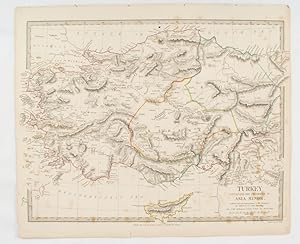
Turkey containing the provinces in Asia Minor.
Verlag: Society for the Diffusion of Useful Knowledge. Baldwin & Cradock., London., 1830
Anbieter: Asia Bookroom ANZAAB/ILAB, Canberra, ACT, Australien
Verkäuferbewertung 5 von 5 Sternen
Engraved map wth outline hand colour, 29.7 x 42 cm, relief shown in hachures, key to abbreviations, including "Ancient Ruins", the west and east extremities attactively engraved to burst through the border, original folds, map with occasional spotting, more pronounced at the lower corner, edges a little ragged, small chip to the inner margin (no loss to the map), manuscript pagination in the lower corner, but in good condition.
-

Firth of Forth. St. Abbs Head to the Forth Bridge.
Verlag: LondonThe Admiralty., 1921
Anbieter: Robert Frew Ltd. ABA ILAB, London, Vereinigtes Königreich
Verbandsmitglied: ABA ILAB PBFA
Verkäuferbewertung 5 von 5 Sternen
Karte
EUR 119,08
EUR 11,56 Versand
Versand von Vereinigtes Königreich nach USAAnzahl: 1 verfügbar
In den Warenkorb63.5 x 111.5 cm. Uncoloured, with principal points (light houses, etc) highighted in orange. Large folding sheet chart of the Firth of Forth. Title in red ink on verso. Some offsetting. Ink stamp to lower right corner.
-
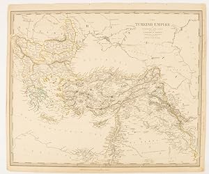
The Turkish Empire in Europe and Asia with the Kingdom of Greece.
Verlag: Charles Knight & Co. [circa1840s.], London., 1840
Anbieter: Asia Bookroom ANZAAB/ILAB, Canberra, ACT, Australien
Verkäuferbewertung 5 von 5 Sternen
Lithographed map with original outline hand-colour, 31.9 x 39.1 cm, small marginal tears neatly repaired with archival material, but no loss, small surface abrasion affecting the border at the foot, edgewear and browning, inked pagination in an early hand, but in very good condition. A handsome map with fine topographical engraving, also showing the borders with Hungary, Russia and Persia.
-

The River Euphrates from Abu' Saide to Werdi.From The Expedition for the Survey of the Euphrates and Tigris, 1836-1840. First edition of the map.
Verlag: [London]: Colonel Chesney, 1849
Anbieter: Wittenborn Art Books, San Francisco, CA, USA
Verkäuferbewertung 5 von 5 Sternen
Kunst / Grafik / Poster
Zustand: Good. Original engraving. Map IV of XII. 50 x 62 x cm. Folding. Marginal tears.The 12 maps were printed separately by the firm of J. & C. Walker, who was the official printer for the British Admiralty and the East India Company. They were published by Colonel Chesney himself in 1849. They were more commonly issued along with Chesney's text volumes, "The Expedition for The Survey of The Rivers Euphrates and Tigris, Carried on by Order of The British Gov. , "published by Longman, Brown, Green, and Longmans, London, 1850.OCLC Number / Unique Identifier:316378697 for the complete set.The Euphrates expedition of 1836 was lead by the British army officer Colonel Francis Rawson Chesney. The main objective was to establish a route "between the Mediterranean Sea and His Majesty's possessions in the East Indies by means of a steam communication of the river Euphrates". Finding a shorter route to India was the hot topic of the time. The East India Company sought a suitable solution to cut down the travel time between England and India. Chesney was involved in initial surveys in Egypt and the Middle East in the late 1820s where he investigated the possibility of passage to India via the Red Sea. In 1829 he submitted a report advocating the construction of the Suez Canal. He also brought to attention the feasibility of steam communication with India through the Euphrates. The king William IV himself expressed a desire that the route by the Euphrates to India should be put to a practical test.In late 1834 when Chesney received funds for the expedition he assembled a capable group of naval and military officers including the explorer Henry Blosse Lynch of the Indian Navy and a geologist William Francis Ainsworth, president of the Royal Physical Society of Edinburgh. He also selected workmen from the Royal Artillery, Royal Sappers and Miners qualified in steam machinery, surveying and drawing. Chesney returned to England in September 1832 after surveying the lower Euphrates by raft and was convinced that the river was navigable, providing a swift route to India. He also believed a British presence in Mesopotamia would discourage Russian encroachment. Chesney had a well-publicised interview with William IV in April 1833, who became an avid supporter of the Euphrates scheme. Petitioning led to the nomination of a select committee which in June 1834 supported an exploratory expedition with the backing of Ł20,000. Chesney was given the temporary rank of Colonel and lead fourteen officers and thirty-nine men on the mission.On 10th February 1835 they sailed for Syria. The two steamships, 'Euphrates' and 'Tigris', had to be tugged in sections over fifty miles of difficult terrain, the Arab tribes along the route were hostile and many of the men, including Chesney, suffered from malaria. On 21st May 1836 a sudden storm hit and the 'Tigris' was wrecked with the loss of twenty lives. . Chesney managed, with the remaining boat, to explore and chart the Euphrates, the Tigris and the Karum rivers. This exploration ended in India and he returned to London in August 1837. This accomplishment won him the admiration of geographers and he was awarded the Geographical Society's gold medal. .After preparing an account of the expedition, Chesney returned to regimental duty in 1841 and by 1843 had risen in rank being appointed Commandant of Hong Kong. In 1847 Chesney returned to England; his last military appointment was as Colonel Commandant of the Cork district, after which he retired to his home at Pacolet, near Kilkeel, county Down, Ireland in 1852.Expertise by Elvire POULAIN &Anne Sophie JONCOUX-PILORGE, Paris.
-

The River Tigris from Nineveh to Kalah Sherakat and from Kalah Sherakat to Samarra. From The Expedition for the Survey of the Euphrates and Tigris, 1836-1840. First edition of the map.
Verlag: [London]: Colonel Chesney, 1849
Anbieter: Wittenborn Art Books, San Francisco, CA, USA
Verkäuferbewertung 5 von 5 Sternen
Kunst / Grafik / Poster
Zustand: Good. Original engraving. Map VI of XII. 61x 50cm. Folding Marginal tears.The 12 maps were printed separately by the firm of J. & C. Walker, who was the official printer for the British Admiralty and the East India Company. They were published by Colonel Chesney himself in 1849. They were more commonly issued along with Chesney's text volumes, "The Expedition for The Survey of The Rivers Euphrates and Tigris, Carried on by Order of The British Gov." published by ongman, Brown, Green, and Longmans, London, 1850.OCLC Number / Unique Identifier:316378697 for the complete set.The Euphrates expedition of 1836 was lead by the British army officer Colonel Francis Rawson Chesney. The main objective was to establish a route "between the Mediterranean Sea and His Majesty's possessions in the East Indies by means of a steam communication of the river Euphrates". Finding a shorter route to India was the hot topic of the time. The East India Company sought a suitable solution to cut down the travel time between England and India. Chesney was involved in initial surveys in Egypt and the Middle East in the late 1820s where he investigated the possibility of passage to India via the Red Sea. In 1829 he submitted a report advocating the construction of the Suez Canal. He also brought to attention the feasibility of steam communication with India through the Euphrates. The king William IV himself expressed a desire that the route by the Euphrates to India should be put to a practical test. In late 1834 when Chesney received funds for the expedition he assembled a capable group of naval and military officers including the explorer Henry Blosse Lynch of the Indian Navy and a geologist William Francis Ainsworth, president of the Royal Physical Society of Edinburgh. He also selected workmen from the Royal Artillery, Royal Sappers and Miners qualified in steam machinery, surveying and drawing. Chesney returned to England in September 1832 after surveying the lower Euphrates by raft and was convinced that the river was navigable, providing a swift route to India. He also believed a British presence in Mesopotamia would discourage Russian encroachment. Chesney had a well-publicised interview with William IV in April 1833, who became an avid supporter of the Euphrates scheme. Petitioning led to the nomination of a select committee which in June 1834 supported an exploratory expedition with the backing of Ł20,000. Chesney was given the temporary rank of Colonel and lead fourteen officers and thirty-nine men on the mission.On 10th February 1835 they sailed for Syria. The two steamships, 'Euphrates' and 'Tigris', had to be tugged in sections over fifty miles of difficult terrain, the Arab tribes along the route were hostile and many of the men, including Chesney, suffered from malaria. On 21st May 1836 a sudden storm hit and the 'Tigris' was wrecked with the loss of twenty lives. Chesney managed, with the remaining boat, to explore and chart the Euphrates, the Tigris and the Karum rivers. This exploration ended in India and he returned to London in August 1837. This accomplishment won him the admiration of geographers and he was awarded the Geographical Society's gold medal. .After preparing an account of the expedition, Chesney returned to regimental duty in 1841 and by 1843 had risen in rank being appointed Commandant of Hong Kong. In 1847 Chesney returned to England; his last military appointment was as Colonel Commandant of the Cork district, after which he retired to his home at Pacolet, near Kilkeel, county Down, Ireland in 1852.Expertise by Elvire POULAIN &Anne Sophie JONCOUX-PILORGE, Paris.
-

The River Euphrates from Ummu-L-Huntah to Ku'rnah with the River Tigris from Serut Castle to Kurnah and the Shatt el 'Arabfrom Kurnah Basrah. From The Expedition for the Survey of the Euphrates and Tigris, 1836-1840. First edition of the map.
Verlag: [London]: Colonel Chesney, 1849
Anbieter: Wittenborn Art Books, San Francisco, CA, USA
Verkäuferbewertung 5 von 5 Sternen
Kunst / Grafik / Poster
Zustand: Good. Original engraving. Map X of XII. 77 x 49.5cm. Folding. Marginal tears and stains in top margin.The 12 maps were printed separately by the firm of J. & C. Walker, who was the official printer for the British Admiralty and the East India Company . They were published by Colonel Chesney himself in 1849. They were more commonly issued along with Chesney's text volumes, "The Expedition for The Survey of The Rivers Euphrates and Tigris, Carried on by Order of The British Gov." published by ongman, Brown, Green, and Longmans, London, 1850.OCLC Number / Unique Identifier:316378697 for the complete set.The Euphrates expedition of 1836 was lead by the British army officer Colonel Francis Rawson Chesney. The main objective was to establish a route "between the Mediterranean Sea and His Majesty's possessions in the East Indies by means of a steam communication of the river Euphrates". Finding a shorter route to India was the hot topic of the time. The East India Company sought a suitable solution to cut down the travel time between England and India. Chesney was involved in initial surveys in Egypt and the Middle East in the late 1820s where he investigated the possibility of passage to India via the Red Sea. In 1829 he submitted a report advocating the construction of the Suez Canal. He also brought to attention the feasibility of steam communication with India through the Euphrates. The king William IV himself expressed a desire that the route by the Euphrates to India should be put to a practical test. In late 1834 when Chesney received funds for the expedition he assembled a capable group of naval and military officers including the explorer Henry Blosse Lynch of the Indian Navy and a geologist William Francis Ainsworth, president of the Royal Physical Society of Edinburgh. He also selected workmen from the Royal Artillery, Royal Sappers and Miners qualified in steam machinery, surveying and drawing. Chesney returned to England in September 1832 after surveying the lower Euphrates by raft and was convinced that the river was navigable, providing a swift route to India. He also believed a British presence in Mesopotamia would discourage Russian encroachment. Chesney had a well-publicised interview with William IV in April 1833, who became an avid supporter of the Euphrates scheme. Petitioning led to the nomination of a select committee which in June 1834 supported an exploratory expedition with the backing of Ł20,000. Chesney was given the temporary rank of Colonel and lead fourteen officers and thirty-nine men on the mission.On 10th February 1835 they sailed for Syria. The two steamships, 'Euphrates' and 'Tigris', had to be tugged in sections over fifty miles of difficult terrain, the Arab tribes along the route were hostile and many of the men, including Chesney, suffered from malaria. On 21st May 1836 a sudden storm hit and the 'Tigris' was wrecked with the loss of twenty lives. Chesney managed, with the remaining boat, to explore and chart the Euphrates, the Tigris and the Karum rivers. This exploration ended in India and he returned to London in August 1837. This accomplishment won him the admiration of geographers and he was awarded the Geographical Society's gold medal. .After preparing an account of the expedition, Chesney returned to regimental duty in 1841 and by 1843 had risen in rank being appointed Commandant of Hong Kong. In 1847 Chesney returned to England; his last military appointment was as Colonel Commandant of the Cork district, after which he retired to his home at Pacolet, near Kilkeel, county Down, Ireland in 1852.Expertise by Elvire POULAIN &Anne Sophie JONCOUX-PILORGE, Paris.
-

The River Euphrates from Hit to the Kuthah River and the River Tigris from Samarra to the Abu Hitti Canal from Samarra toDokhala and from Dokhala to the Abu Hitti Canal. From The Expedition for the Survey of the Euphrates and Tigris, 1836-1840. First edition of the map.
Verlag: [London]: Colonel Chesney, 1849
Anbieter: Wittenborn Art Books, San Francisco, CA, USA
Verkäuferbewertung 5 von 5 Sternen
Kunst / Grafik / Poster
Zustand: Good. Original engraving. Map VII of XII. 50 x 62.5cm. Folding. Marginal tears.The 12 maps were printed separately by the firm of J. & C. Walker, who was the official printer for the British Admiralty and the East India Company . They were published by Colonel Chesney himself in 1849. They were more commonly issued along with Chesney's text volumes, "The Expedition for The Survey of The Rivers Euphrates and Tigris, Carried on by Order of The British Gov." published by ongman, Brown, Green, and Longmans, London, 1850.OCLC Number / Unique Identifier:316378697 for the complete set.The Euphrates expedition of 1836 was lead by the British army officer Colonel Francis Rawson Chesney. The main objective was to establish a route "between the Mediterranean Sea and His Majesty's possessions in the East Indies by means of a steam communication of the river Euphrates". Finding a shorter route to India was the hot topic of the time. The East India Company sought a suitable solution to cut down the travel time between England and India. Chesney was involved in initial surveys in Egypt and the Middle East in the late 1820s where he investigated the possibility of passage to India via the Red Sea. In 1829 he submitted a report advocating the construction of the Suez Canal. He also brought to attention the feasibility of steam communication with India through the Euphrates. The king William IV himself expressed a desire that the route by the Euphrates to India should be put to a practical test. In late 1834 when Chesney received funds for the expedition he assembled a capable group of naval and military officers including the explorer Henry Blosse Lynch of the Indian Navy and a geologist William Francis Ainsworth, president of the Royal Physical Society of Edinburgh. He also selected workmen from the Royal Artillery, Royal Sappers and Miners qualified in steam machinery, surveying and drawing. Chesney returned to England in September 1832 after surveying the lower Euphrates by raft and was convinced that the river was navigable, providing a swift route to India. He also believed a British presence in Mesopotamia would discourage Russian encroachment. Chesney had a well-publicised interview with William IV in April 1833, who became an avid supporter of the Euphrates scheme. Petitioning led to the nomination of a select committee which in June 1834 supported an exploratory expedition with the backing of Ł20,000. Chesney was given the temporary rank of Colonel and lead fourteen officers and thirty-nine men on the mission.On 10th February 1835 they sailed for Syria. The two steamships, 'Euphrates' and 'Tigris', had to be tugged in sections over fifty miles of difficult terrain, the Arab tribes along the route were hostile and many of the men, including Chesney, suffered from malaria. On 21st May 1836 a sudden storm hit and the 'Tigris' was wrecked with the loss of twenty lives. Chesney managed, with the remaining boat, to explore and chart the Euphrates, the Tigris and the Karum rivers. This exploration ended in India and he returned to London in August 1837. This accomplishment won him the admiration of geographers and he was awarded the Geographical Society's gold medal. .After preparing an account of the expedition, Chesney returned to regimental duty in 1841 and by 1843 had risen in rank being appointed Commandant of Hong Kong. In 1847 Chesney returned to England; his last military appointment was as Colonel Commandant of the Cork district, after which he retired to his home at Pacolet, near Kilkeel, county Down, Ireland in 1852.Expertise by Elvire POULAIN &Anne Sophie JONCOUX-PILORGE, Paris.
-

The River Euphrates from Werdi to Hit. From The Expedition for the Survey of the Euphrates and Tigris, 1836-1840. First edition of the map.
Verlag: [London]: Colonel Chesney, 1849
Anbieter: Wittenborn Art Books, San Francisco, CA, USA
Verkäuferbewertung 5 von 5 Sternen
Kunst / Grafik / Poster
Zustand: Good. Original engraving. Map V of XII. 50.5 x 60cm. Folding. Marginal tears.The 12 maps were printed separately by the firm of J. & C. Walker, who was the official printer for the British Admiralty and the East India Company. They were published by Colonel Chesney himself in 1849. They were more commonly issued along with Chesney's text volumes, "The Expedition for The Survey of The Rivers Euphrates and Tigris, Carried on by Order of The British Gov." published by ongman, Brown, Green, and Longmans, London, 1850.OCLC Number / Unique Identifier:316378697 for the complete set.The Euphrates expedition of 1836 was lead by the British army officer Colonel Francis Rawson Chesney. The main objective was to establish a route "between the Mediterranean Sea and His Majesty's possessions in the East Indies by means of a steam communication of the river Euphrates". Finding a shorter route to India was the hot topic of the time. The East India Company sought a suitable solution to cut down the travel time between England and India. Chesney was involved in initial surveys in Egypt and the Middle East in the late 1820s where he investigated the possibility of passage to India via the Red Sea. In 1829 he submitted a report advocating the construction of the Suez Canal. He also brought to attention the feasibility of steam communication with India through the Euphrates. The king William IV himself expressed a desire that the route by the Euphrates to India should be put to a practical test. In late 1834 when Chesney received funds for the expedition he assembled a capable group of naval and military officers including the explorer Henry Blosse Lynch of the Indian Navy and a geologist William Francis Ainsworth, president of the Royal Physical Society of Edinburgh. He also selected workmen from the Royal Artillery, Royal Sappers and Miners qualified in steam machinery, surveying and drawing. Chesney returned to England in September 1832 after surveying the lower Euphrates by raft and was convinced that the river was navigable, providing a swift route to India. He also believed a British presence in Mesopotamia would discourage Russian encroachment. Chesney had a well-publicised interview with William IV in April 1833, who became an avid supporter of the Euphrates scheme. Petitioning led to the nomination of a select committee which in June 1834 supported an exploratory expedition with the backing of Ł20,000. Chesney was given the temporary rank of Colonel and lead fourteen officers and thirty-nine men on the mission.On 10th February 1835 they sailed for Syria. The two steamships, 'Euphrates' and 'Tigris', had to be tugged in sections over fifty miles of difficult terrain, the Arab tribes along the route were hostile and many of the men, including Chesney, suffered from malaria. On 21st May 1836 a sudden storm hit and the 'Tigris' was wrecked with the loss of twenty lives. Chesney managed, with the remaining boat, to explore and chart the Euphrates, the Tigris and the Karum rivers. This exploration ended in India and he returned to London in August 1837. This accomplishment won him the admiration of geographers and he was awarded the Geographical Society's gold medal. .After preparing an account of the expedition, Chesney returned to regimental duty in 1841 and by 1843 had risen in rank being appointed Commandant of Hong Kong. In 1847 Chesney returned to England; his last military appointment was as Colonel Commandant of the Cork district, after which he retired to his home at Pacolet, near Kilkeel, county Down, Ireland in 1852.Expertise by Elvire POULAIN &Anne Sophie JONCOUX-PILORGE, Paris.
-

The River Euphrates from Kal 'At En Nejm to Abu' Saide. From The Expedition for the Survey of the Euphrates and Tigris, 1836-1840. First edition of the map.
Verlag: [London]: Colonel Chesney, 1849
Anbieter: Wittenborn Art Books, San Francisco, CA, USA
Verkäuferbewertung 5 von 5 Sternen
Kunst / Grafik / Poster
Zustand: Good. Original engraving. Map III of XII. 50 x 62cm. Marginal tears.The 12 maps were printed separately by the firm of J. & C. Walker, who was the official printer for the British Admiralty and the East India Company . They were published by Colonel Chesney himself in 1849. They were more commonly issued along with Chesney's text volumes, "The Expedition for The Survey of The Rivers Euphrates and Tigris, Carried on by Order of The British Gov." published by ongman, Brown, Green, and Longmans, London, 1850.OCLC Number / Unique Identifier:316378697;.The Euphrates expedition of 1836 was lead by the British army officer Colonel Francis Rawson Chesney. The main objective was to establish a route "between the Mediterranean Sea and His Majesty's possessions in the East Indies by means of a steam communication of the river Euphrates". Finding a shorter route to India was the hot topic of the time. The East India Company sought a suitable solution to cut down the travel time between England and India. Chesney was involved in initial surveys in Egypt and the Middle East in the late 1820s where he investigated the possibility of passage to India via the Red Sea. In 1829 he submitted a report advocating the construction of the Suez Canal. He also brought to attention the feasibility of steam communication with India through the Euphrates. The king William IV himself expressed a desire that the route by the Euphrates to India should be put to a practical test.In late 1834 when Chesney received funds for the expedition he assembled a capable group of naval and military officers including the explorer Henry Blosse Lynch of the Indian Navy and a geologist William Francis Ainsworth, president of the Royal Physical Society of Edinburgh. He also selected workmen from the Royal Artillery, Royal Sappers and Miners qualified in steam machinery, surveying and drawing. Chesney returned to England in September 1832 after surveying the lower Euphrates by raft and was convinced that the river was navigable, providing a swift route to India. He also believed a British presence in Mesopotamia would discourage Russian encroachment. Chesney had a well-publicised interview with William IV in April 1833, who became an avid supporter of the Euphrates scheme. Petitioning led to the nomination of a select committee which in June 1834 supported an exploratory expedition with the backing of Ł20,000. Chesney was given the temporary rank of Colonel and lead fourteen officers and thirty-nine men on the mission.On 10th February 1835 they sailed for Syria. The two steamships, 'Euphrates' and 'Tigris', had to be tugged in sections over fifty miles of difficult terrain, the Arab tribes along the route were hostile and many of the men, including Chesney, suffered from malaria. On 21st May 1836 a sudden storm hit and the 'Tigris' was wrecked with the loss of twenty lives. Chesney managed, with the remaining boat, to explore and chart the Euphrates, the Tigris and the Karum rivers. This exploration ended in India and he returned to London in August 1837. This accomplishment won him the admiration of geographers and he was awarded the Geographical Society's gold medal. .After preparing an account of the expedition, Chesney returned to regimental duty in 1841 and by 1843 had risen in rank being appointed Commandant of Hong Kong. In 1847 Chesney returned to England; his last military appointment was as Colonel Commandant of the Cork district, after which he retired to his home at Pacolet, near Kilkeel, county Down, Ireland in 1852.Expertise by Elvire POULAIN &Anne Sophie JONCOUX-PILORGE, Paris.
-

The Shatt el 'Arab from Basrah to the Bar of the River Euphrates and the River Karu'n.From Salmanah Isle to Mohommerah with Bah-A- Mishir.From The Expedition for the Survey of the Euphrates and Tigris, 1836-1840. First edition of the map.
Verlag: [London]: Colonel Chesney, 1849
Anbieter: Wittenborn Art Books, San Francisco, CA, USA
Verkäuferbewertung 5 von 5 Sternen
Kunst / Grafik / Poster
Zustand: Good. Original engraving. Map XII of XII. 49.8 x 63 cm. Folding. Marginal tears and stains in top margin.The 12 maps were printed separately by the firm of J. & C. Walker, who was the official printer for the British Admiralty and the East India Company . They were published by Colonel Chesney himself in 1849. They were more commonly issued along with Chesney's text volumes, "The Expedition for The Survey of The Rivers Euphrates and Tigris, Carried on by Order of The British Gov." published by ongman, Brown, Green, and Longmans, London, 1850.OCLC Number / Unique Identifier:316378697 for the complete set.The Euphrates expedition of 1836 was lead by the British army officer Colonel Francis Rawson Chesney. The main objective was to establish a route "between the Mediterranean Sea and His Majesty's possessions in the East Indies by means of a steam communication of the river Euphrates". Finding a shorter route to India was the hot topic of the time. The East India Company sought a suitable solution to cut down the travel time between England and India. Chesney was involved in initial surveys in Egypt and the Middle East in the late 1820s where he investigated the possibility of passage to India via the Red Sea. In 1829 he submitted a report advocating the construction of the Suez Canal. He also brought to attention the feasibility of steam communication with India through the Euphrates. The king William IV himself expressed a desire that the route by the Euphrates to India should be put to a practical test. In late 1834 when Chesney received funds for the expedition he assembled a capable group of naval and military officers including the explorer Henry Blosse Lynch of the Indian Navy and a geologist William Francis Ainsworth, president of the Royal Physical Society of Edinburgh. He also selected workmen from the Royal Artillery, Royal Sappers and Miners qualified in steam machinery, surveying and drawing. Chesney returned to England in September 1832 after surveying the lower Euphrates by raft and was convinced that the river was navigable, providing a swift route to India. He also believed a British presence in Mesopotamia would discourage Russian encroachment. Chesney had a well-publicised interview with William IV in April 1833, who became an avid supporter of the Euphrates scheme. Petitioning led to the nomination of a select committee which in June 1834 supported an exploratory expedition with the backing of Ł20,000. Chesney was given the temporary rank of Colonel and lead fourteen officers and thirty-nine men on the mission.On 10th February 1835 they sailed for Syria. The two steamships, 'Euphrates' and 'Tigris', had to be tugged in sections over fifty miles of difficult terrain, the Arab tribes along the route were hostile and many of the men, including Chesney, suffered from malaria. On 21st May 1836 a sudden storm hit and the 'Tigris' was wrecked with the loss of twenty lives. Chesney managed, with the remaining boat, to explore and chart the Euphrates, the Tigris and the Karum rivers. This exploration ended in India and he returned to London in August 1837. This accomplishment won him the admiration of geographers and he was awarded the Geographical Society's gold medal. .After preparing an account of the expedition, Chesney returned to regimental duty in 1841 and by 1843 had risen in rank being appointed Commandant of Hong Kong. In 1847 Chesney returned to England; his last military appointment was as Colonel Commandant of the Cork district, after which he retired to his home at Pacolet, near Kilkeel, county Down, Ireland in 1852.Expertise by Elvire POULAIN &Anne Sophie JONCOUX-PILORGE, Paris.
-

The River Euphrates from the Kuthah River to El Wuja Island and Village also the River Tigris from the Abu Hitti Canal to JudifahIsland. From The Expedition for the Survey of the Euphrates and Tigris, 1836-1840. First edition of the map.
Verlag: [London]: Colonel Chesney, 1849
Anbieter: Wittenborn Art Books, San Francisco, CA, USA
Verkäuferbewertung 5 von 5 Sternen
Kunst / Grafik / Poster
Zustand: Good. Original engraving. Map VIII of XII. 63 x 50.5cm. Folding. Marginal tears.The 12 maps were printed separately by the firm of J. & C. Walker, who was the official printer for the British Admiralty and the East India Company . They were published by Colonel Chesney himself in 1849. They were more commonly issued along with Chesney's text volumes, "The Expedition for The Survey of The Rivers Euphrates and Tigris, Carried on by Order of The British Gov." published by ongman, Brown, Green, and Longmans, London, 1850.OCLC Number / Unique Identifier:316378697 for the complete set.The Euphrates expedition of 1836 was lead by the British army officer Colonel Francis Rawson Chesney. The main objective was to establish a route "between the Mediterranean Sea and His Majesty's possessions in the East Indies by means of a steam communication of the river Euphrates". Finding a shorter route to India was the hot topic of the time. The East India Company sought a suitable solution to cut down the travel time between England and India. Chesney was involved in initial surveys in Egypt and the Middle East in the late 1820s where he investigated the possibility of passage to India via the Red Sea. In 1829 he submitted a report advocating the construction of the Suez Canal. He also brought to attention the feasibility of steam communication with India through the Euphrates. The king William IV himself expressed a desire that the route by the Euphrates to India should be put to a practical test. In late 1834 when Chesney received funds for the expedition he assembled a capable group of naval and military officers including the explorer Henry Blosse Lynch of the Indian Navy and a geologist William Francis Ainsworth, president of the Royal Physical Society of Edinburgh. He also selected workmen from the Royal Artillery, Royal Sappers and Miners qualified in steam machinery, surveying and drawing. Chesney returned to England in September 1832 after surveying the lower Euphrates by raft and was convinced that the river was navigable, providing a swift route to India. He also believed a British presence in Mesopotamia would discourage Russian encroachment. Chesney had a well-publicised interview with William IV in April 1833, who became an avid supporter of the Euphrates scheme. Petitioning led to the nomination of a select committee which in June 1834 supported an exploratory expedition with the backing of Ł20,000. Chesney was given the temporary rank of Colonel and lead fourteen officers and thirty-nine men on the mission.On 10th February 1835 they sailed for Syria. The two steamships, 'Euphrates' and 'Tigris', had to be tugged in sections over fifty miles of difficult terrain, the Arab tribes along the route were hostile and many of the men, including Chesney, suffered from malaria. On 21st May 1836 a sudden storm hit and the 'Tigris' was wrecked with the loss of twenty lives. Chesney managed, with the remaining boat, to explore and chart the Euphrates, the Tigris and the Karum rivers. This exploration ended in India and he returned to London in August 1837. This accomplishment won him the admiration of geographers and he was awarded the Geographical Society's gold medal. .After preparing an account of the expedition, Chesney returned to regimental duty in 1841 and by 1843 had risen in rank being appointed Commandant of Hong Kong. In 1847 Chesney returned to England; his last military appointment was as Colonel Commandant of the Cork district, after which he retired to his home at Pacolet, near Kilkeel, county Down, Ireland in 1852.Expertise by Elvire POULAIN &Anne Sophie JONCOUX-PILORGE, Paris.
-

The River Karun from Shuster to Salmanah Island from Shuster to Band-i-kir. - and from Band-i-kir to Salmanah Island and the Dorak Canal.From The Expedition for the Survey of the Euphrates and Tigris, 1836-1840. First edition of the map.
Verlag: [London]: Colonel Chesney, 1849
Anbieter: Wittenborn Art Books, San Francisco, CA, USA
Verkäuferbewertung 5 von 5 Sternen
Kunst / Grafik / Poster
Zustand: Good. Original engraving. Map XI of XII. 64 x 50.5cm. Folding. Marginal tears and stains in top margin.The 12 maps were printed separately by the firm of J. & C. Walker, who was the official printer for the British Admiralty and the East India Company . They were published by Colonel Chesney himself in 1849. They were more commonly issued along with Chesney's text volumes, "The Expedition for The Survey of The Rivers Euphrates and Tigris, Carried on by Order of The British Gov." published by ongman, Brown, Green, and Longmans, London, 1850.OCLC Number / Unique Identifier:316378697 for the complete set.The Euphrates expedition of 1836 was lead by the British army officer Colonel Francis Rawson Chesney. The main objective was to establish a route "between the Mediterranean Sea and His Majesty's possessions in the East Indies by means of a steam communication of the river Euphrates". Finding a shorter route to India was the hot topic of the time. The East India Company sought a suitable solution to cut down the travel time between England and India. Chesney was involved in initial surveys in Egypt and the Middle East in the late 1820s where he investigated the possibility of passage to India via the Red Sea. In 1829 he submitted a report advocating the construction of the Suez Canal. He also brought to attention the feasibility of steam communication with India through the Euphrates. The king William IV himself expressed a desire that the route by the Euphrates to India should be put to a practical test. In late 1834 when Chesney received funds for the expedition he assembled a capable group of naval and military officers including the explorer Henry Blosse Lynch of the Indian Navy and a geologist William Francis Ainsworth, president of the Royal Physical Society of Edinburgh. He also selected workmen from the Royal Artillery, Royal Sappers and Miners qualified in steam machinery, surveying and drawing. Chesney returned to England in September 1832 after surveying the lower Euphrates by raft and was convinced that the river was navigable, providing a swift route to India. He also believed a British presence in Mesopotamia would discourage Russian encroachment. Chesney had a well-publicised interview with William IV in April 1833, who became an avid supporter of the Euphrates scheme. Petitioning led to the nomination of a select committee which in June 1834 supported an exploratory expedition with the backing of Ł20,000. Chesney was given the temporary rank of Colonel and lead fourteen officers and thirty-nine men on the mission.On 10th February 1835 they sailed for Syria. The two steamships, 'Euphrates' and 'Tigris', had to be tugged in sections over fifty miles of difficult terrain, the Arab tribes along the route were hostile and many of the men, including Chesney, suffered from malaria. On 21st May 1836 a sudden storm hit and the 'Tigris' was wrecked with the loss of twenty lives. Chesney managed, with the remaining boat, to explore and chart the Euphrates, the Tigris and the Karum rivers. This exploration ended in India and he returned to London in August 1837. This accomplishment won him the admiration of geographers and he was awarded the Geographical Society's gold medal. .After preparing an account of the expedition, Chesney returned to regimental duty in 1841 and by 1843 had risen in rank being appointed Commandant of Hong Kong. In 1847 Chesney returned to England; his last military appointment was as Colonel Commandant of the Cork district, after which he retired to his home at Pacolet, near Kilkeel, county Down, Ireland in 1852.Expertise by Elvire POULAIN &Anne Sophie JONCOUX-PILORGE, Paris.
