
Gesamtpreis (1 Artikel Artikel):
Versandziel:

c engr (30 Ergebnisse)
Direkt zu den wichtigsten Suchergebnissen
Suchfilter
Produktart
- Alle Product Types
- Bücher (11)
- Magazine & Zeitschriften (Keine weiteren Ergebnisse entsprechen dieser Verfeinerung)
- Comics (Keine weiteren Ergebnisse entsprechen dieser Verfeinerung)
- Noten (Keine weiteren Ergebnisse entsprechen dieser Verfeinerung)
- Kunst, Grafik & Poster (Keine weiteren Ergebnisse entsprechen dieser Verfeinerung)
- Fotografien (Keine weiteren Ergebnisse entsprechen dieser Verfeinerung)
- Karten (18)
- Manuskripte & Papierantiquitäten (1)
Zustand Mehr dazu
- Neu (3)
- Wie Neu, Sehr Gut oder Gut Bis Sehr Gut (Keine weiteren Ergebnisse entsprechen dieser Verfeinerung)
- Gut oder Befriedigend (3)
- Ausreichend oder Schlecht (Keine weiteren Ergebnisse entsprechen dieser Verfeinerung)
- Wie beschrieben (24)
Einband
Weitere Eigenschaften
- Erstausgabe (1)
- Signiert (Keine weiteren Ergebnisse entsprechen dieser Verfeinerung)
- Schutzumschlag (Keine weiteren Ergebnisse entsprechen dieser Verfeinerung)
- Angebotsfoto (26)
Sprache (3)
Gratisversand
- Kostenloser Versand nach USA (Keine weiteren Ergebnisse entsprechen dieser Verfeinerung)
Land des Verkäufers
Verkäuferbewertung
-

STRANGE THINGS IN ZION: and other plays
Anbieter: Ria Christie Collections, Uxbridge, Vereinigtes Königreich
Verkäuferbewertung 5 von 5 Sternen

EUR 9,18
EUR 13,88 Versand
Versand von Vereinigtes Königreich nach USAAnzahl: Mehr als 20 verfügbar
In den WarenkorbZustand: New. In.
-

TRAIN ME: The yearning of every child
Anbieter: Ria Christie Collections, Uxbridge, Vereinigtes Königreich
Verkäuferbewertung 5 von 5 Sternen
EUR 10,83
EUR 13,88 Versand
Versand von Vereinigtes Königreich nach USAAnzahl: Mehr als 20 verfügbar
In den WarenkorbZustand: New. In.
-
The Yale Literary Magazine, Centennial Number No. CI, No. 6, February 1936
Verlag: New Haven, The Yale Literary Magazine, 1936
Anbieter: Cragsmoor Books, Cragsmoor, NY, USA
Verkäuferbewertung 5 von 5 Sternen
Hardcover. Zustand: Good. No Jacket. Cream bds, bkstr. sl. torn, with small piece missing, rear hinge cracking, contents clean & sound. Xiv, 224, lvi pp. incl. ads, list of editors, etc. Contributors include William Lyon Phelps, Sinclair Lewis; Archibald MacLeish; Walter Millis; Thornton Wilder et al.
-

DREAMING OF CUPCAKES: A FOOD ADDICT'S SH
Anbieter: Speedyhen, Hertfordshire, Vereinigtes Königreich
Verkäuferbewertung 5 von 5 Sternen
EUR 21,93
EUR 47,50 Versand
Versand von Vereinigtes Königreich nach USAAnzahl: 1 verfügbar
In den WarenkorbZustand: NEW.
-
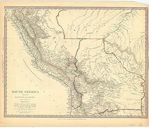
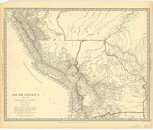
South America / Sheet VI / Bolivia and Peru with a Part of Brazil.
Verlag: LondonSociety for the Distribution of Useful Knowledge. ND but c., 1840
Anbieter: Robert Frew Ltd. ABA ILAB, London, Vereinigtes Königreich
Verbandsmitglied: ABA ILAB PBFA
Verkäuferbewertung 5 von 5 Sternen
Karte
EUR 29,83
EUR 11,59 Versand
Versand von Vereinigtes Königreich nach USAAnzahl: 1 verfügbar
In den Warenkorb30.3 x 39.1 cm overall. Original outline colour, with additional colour to printed border. Single page steel engraved map. Good condition.
-
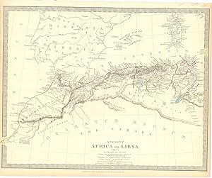
Ancient Africa or Libya / Part I.
Verlag: LondonSociety for the Distribution of Useful Knowledge. but 1849, 1840
Anbieter: Robert Frew Ltd. ABA ILAB, London, Vereinigtes Königreich
Verbandsmitglied: ABA ILAB PBFA
Verkäuferbewertung 5 von 5 Sternen
Karte
EUR 29,83
EUR 11,59 Versand
Versand von Vereinigtes Königreich nach USAAnzahl: 1 verfügbar
In den Warenkorb31 x 39.5 cm. Original outline colour. Single page steel engraved historical map of North Western Africa. Good condition.
-
![Bild des Verkäufers für India / IV / [Orissa]. zum Verkauf von Robert Frew Ltd. ABA ILAB](https://pictures.abebooks.com/inventory/md/md17237130763.jpg)
India / IV / [Orissa].
Verlag: LondonGeorge Cox. but 1857, 1853
Anbieter: Robert Frew Ltd. ABA ILAB, London, Vereinigtes Königreich
Verbandsmitglied: ABA ILAB PBFA
Verkäuferbewertung 5 von 5 Sternen
Karte
EUR 29,83
EUR 11,59 Versand
Versand von Vereinigtes Königreich nach USAAnzahl: 1 verfügbar
In den Warenkorb26.2 x 35.2 cm. Original outline colour. Single page steel engraved map of Orissa and the surrounding region. A few very short marginal tears, otherwise in good condition.
-

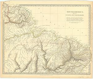
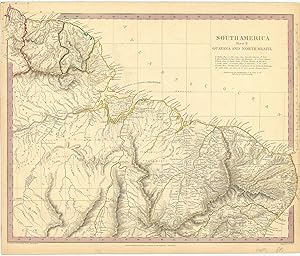
South America / Sheet II / Guayana and North Brazil.
Verlag: LondonSociety for the Distribution of Useful Knowledge., 1836
Anbieter: Robert Frew Ltd. ABA ILAB, London, Vereinigtes Königreich
Verbandsmitglied: ABA ILAB PBFA
Verkäuferbewertung 5 von 5 Sternen
Karte
EUR 29,83
EUR 11,59 Versand
Versand von Vereinigtes Königreich nach USAAnzahl: 1 verfügbar
In den Warenkorb31.2 x 39.1 cm overall. Original outline colour. Single page steel engraved map. Good condition.
-
![Bild des Verkäufers für India / VI / [Malwa]. zum Verkauf von Robert Frew Ltd. ABA ILAB](https://pictures.abebooks.com/inventory/md/md17237130764.jpg)
India / VI / [Malwa].
Verlag: LondonEdward Stanford., 1857
Anbieter: Robert Frew Ltd. ABA ILAB, London, Vereinigtes Königreich
Verbandsmitglied: ABA ILAB PBFA
Verkäuferbewertung 5 von 5 Sternen
Karte
EUR 29,83
EUR 11,59 Versand
Versand von Vereinigtes Königreich nach USAAnzahl: 1 verfügbar
In den Warenkorb26.5 x 35.2 cm. Original outline colour. Single page steel engraved map of the old region of Malwa, now Madhya Pradesh. Good condition.
-
![Bild des Verkäufers für India / VI / [Malwa]. zum Verkauf von Robert Frew Ltd. ABA ILAB](https://pictures.abebooks.com/inventory/md/md17237130765.jpg)
India / VI / [Malwa].
Verlag: LondonBaldwin & Craddock. but 1849, 1833
Anbieter: Robert Frew Ltd. ABA ILAB, London, Vereinigtes Königreich
Verbandsmitglied: ABA ILAB PBFA
Verkäuferbewertung 5 von 5 Sternen
Karte
EUR 29,83
EUR 11,59 Versand
Versand von Vereinigtes Königreich nach USAAnzahl: 1 verfügbar
In den Warenkorb26 x 35.8 cm. Original outline colour. Single page steel engraved map of the old region of Malwa, now Madhya Pradesh. Good condition.
-
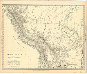
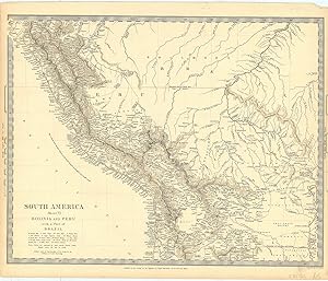
South America / Sheet VI / Bolivia and Peru with a Part of Brazil.
Verlag: LondonSociety for the Distribution of Useful Knowledge. ND but c., 1840
Anbieter: Robert Frew Ltd. ABA ILAB, London, Vereinigtes Königreich
Verbandsmitglied: ABA ILAB PBFA
Verkäuferbewertung 5 von 5 Sternen
Karte
EUR 29,83
EUR 11,59 Versand
Versand von Vereinigtes Königreich nach USAAnzahl: 1 verfügbar
In den Warenkorb30.8 x 39.1 cm overall. Original outline colour. Single page steel engraved map. Good condition.
-
South America / Sheet II / Guayana and North Brazil.
Verlag: LondonSociety for the Distribution of Useful Knowledge., 1836
Anbieter: Robert Frew Ltd. ABA ILAB, London, Vereinigtes Königreich
Verbandsmitglied: ABA ILAB PBFA
Verkäuferbewertung 5 von 5 Sternen
Karte
EUR 29,83
EUR 11,59 Versand
Versand von Vereinigtes Königreich nach USAAnzahl: 1 verfügbar
In den Warenkorb30.8 x 39 cm overall. Original outline colour. Single page steel engraved map. Good condition.
-
![Bild des Verkäufers für India / VII / [North Eastern India]. zum Verkauf von Robert Frew Ltd. ABA ILAB](https://pictures.abebooks.com/inventory/md/md17237130767.jpg)
India / VII / [North Eastern India].
Verlag: LondonEdward Stanford., 1857
Anbieter: Robert Frew Ltd. ABA ILAB, London, Vereinigtes Königreich
Verbandsmitglied: ABA ILAB PBFA
Verkäuferbewertung 5 von 5 Sternen
Karte
EUR 29,83
EUR 11,59 Versand
Versand von Vereinigtes Königreich nach USAAnzahl: 1 verfügbar
In den Warenkorb26.2 x 35.5 cm. Original outline colour. Single page steel engraved map of north eastern India, encompassing parts of Orissa, Madhya Pradesh and Bihar. Good condition.
-
![Bild des Verkäufers für India / VII / [North Eastern India]. zum Verkauf von Robert Frew Ltd. ABA ILAB](https://pictures.abebooks.com/inventory/md/md17237130766.jpg)
India / VII / [North Eastern India].
Verlag: LondonBaldwin & Craddock. but 1849, 1832
Anbieter: Robert Frew Ltd. ABA ILAB, London, Vereinigtes Königreich
Verbandsmitglied: ABA ILAB PBFA
Verkäuferbewertung 5 von 5 Sternen
Karte
EUR 29,83
EUR 11,59 Versand
Versand von Vereinigtes Königreich nach USAAnzahl: 1 verfügbar
In den Warenkorb26.1 x 35 cm. Original outline colour. Single page steel engraved map of north eastern India, encompassing parts of Orissa, Madhya Pradesh and Bihar. Good condition.
-
![Bild des Verkäufers für [Americas]. zum Verkauf von Robert Frew Ltd. ABA ILAB](https://pictures.abebooks.com/inventory/md/md17237130769.jpg)
[Americas].
Verlag: LondonGeorge Cox. but 1857, 1853
Anbieter: Robert Frew Ltd. ABA ILAB, London, Vereinigtes Königreich
Verbandsmitglied: ABA ILAB PBFA
Verkäuferbewertung 5 von 5 Sternen
Karte
EUR 29,83
EUR 11,59 Versand
Versand von Vereinigtes Königreich nach USAAnzahl: 1 verfügbar
In den Warenkorb27.5 x 26 cm. Original outline colour. Single page steel engraved map showing the US down to southern Argentina and Chile. Good condition.
-
South America / Sheet II / Guayana and North Brazil.
Verlag: LondonSociety for the Distribution of Useful Knowledge., 1836
Anbieter: Robert Frew Ltd. ABA ILAB, London, Vereinigtes Königreich
Verbandsmitglied: ABA ILAB PBFA
Verkäuferbewertung 5 von 5 Sternen
Karte
EUR 29,83
EUR 11,59 Versand
Versand von Vereinigtes Königreich nach USAAnzahl: 1 verfügbar
In den Warenkorb31 x 39 cm overall. Original outline colour, with additional colour to printed border. Single page steel engraved map. Good condition.
-
South America / Sheet VI / Bolivia and Peru with a Part of Brazil.
Verlag: LondonSociety for the Distribution of Useful Knowledge. ND but c., 1840
Anbieter: Robert Frew Ltd. ABA ILAB, London, Vereinigtes Königreich
Verbandsmitglied: ABA ILAB PBFA
Verkäuferbewertung 5 von 5 Sternen
Karte
EUR 29,83
EUR 11,59 Versand
Versand von Vereinigtes Königreich nach USAAnzahl: 1 verfügbar
In den Warenkorb30.5 x 39.3 cm overall. Original outline colour. Single page steel engraved map. Good condition.
-
South America / Sheet VI / Bolivia and Peru with a Part of Brazil.
Verlag: LondonSociety for the Distribution of Useful Knowledge. ND but c., 1840
Anbieter: Robert Frew Ltd. ABA ILAB, London, Vereinigtes Königreich
Verbandsmitglied: ABA ILAB PBFA
Verkäuferbewertung 5 von 5 Sternen
Karte
EUR 29,83
EUR 11,59 Versand
Versand von Vereinigtes Königreich nach USAAnzahl: 1 verfügbar
In den Warenkorb30.9 x 39.3 cm overall. Uncoloured. Single page steel engraved map. Good condition.
-

South America / Sheet II / Guayana and North Brazil.
Verlag: LondonSociety for the Distribution of Useful Knowledge., 1836
Anbieter: Robert Frew Ltd. ABA ILAB, London, Vereinigtes Königreich
Verbandsmitglied: ABA ILAB PBFA
Verkäuferbewertung 5 von 5 Sternen
Karte
EUR 29,83
EUR 11,59 Versand
Versand von Vereinigtes Königreich nach USAAnzahl: 1 verfügbar
In den Warenkorb30.6 x 39 cm overall. Original outline colour. Single page steel engraved map. Good condition.
-
![Bild des Verkäufers für India / III / [Bombay Presidency]. zum Verkauf von Robert Frew Ltd. ABA ILAB](https://pictures.abebooks.com/inventory/md/md17237130761.jpg)
India / III / [Bombay Presidency].
Verlag: LondonGeorge Cox. but 1857, 1853
Anbieter: Robert Frew Ltd. ABA ILAB, London, Vereinigtes Königreich
Verbandsmitglied: ABA ILAB PBFA
Verkäuferbewertung 5 von 5 Sternen
Karte
EUR 29,83
EUR 11,59 Versand
Versand von Vereinigtes Königreich nach USAAnzahl: 1 verfügbar
In den Warenkorb26 x 36.6 cm. Original outline colour. Single page steel engraved map of western and central India. Good condition.
-
National History and Views of London and its Environs: Embracing their Antiquities, Modern Improvements etc. etc. From Original Drawings by Eminent Artists. Volume I & II (Complete two volume set)
Sprache: Englisch
Verlag: Black, Young & Young / Simpkin and Marshall; Oliver and Boyd; W. Curry & Co., London, 1834
Anbieter: Tarrington Books, Tarrington, HEF, Vereinigtes Königreich
Verkäuferbewertung 5 von 5 Sternen
EUR 220,77
EUR 38,23 Versand
Versand von Vereinigtes Königreich nach USAAnzahl: 1 verfügbar
In den WarenkorbZustand: Very Good Minus. Complete two volume set. Publisher's blind stamped maroon leather bindings. All edges gilt. Rubbing to edges of boards and spines. Wear to corners. Good solid bindings with no cracking to joints. Frontis and engraved title page (dated 1835) followed by letterpress title page (dated 1834). Numerous plates, each with five steel engravings (300 engravings in total). Tissue guard to each plate. Patches of foxing and occasional marks to the text and plates. Overall condition is Very Good Minus. Size: 6 x 9.5 inches (15 x 24 cm). Hardback. Printed pages: Large 8vo. viii, 208; viii, 216.
-
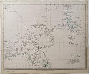
West Africa / II.
Verlag: LondonSociety for the Distribution of Useful Knowledge., 1851
Anbieter: Robert Frew Ltd. ABA ILAB, London, Vereinigtes Königreich
Verbandsmitglied: ABA ILAB PBFA
Verkäuferbewertung 5 von 5 Sternen
Karte
EUR 59,67
EUR 11,59 Versand
Versand von Vereinigtes Königreich nach USAAnzahl: 1 verfügbar
In den Warenkorb33 x 41 cm. Original outline colour. Single page steel engraved map of western Africa encompassing what is now eastern Ghana, Togo and Nigeria. The map extends as far inland as Lake Chad. Good condition.
-

[Figures de l'histoire de France. Vol I (only),
Verlag: Paris, 1778-79].; 4to (26cm). 72 engr pls., 1779
Anbieter: Bennett and Kerr Books, ABINGDON, Vereinigtes Königreich
Verkäuferbewertung 5 von 5 Sternen
EUR 149,17
EUR 18,54 Versand
Versand von Vereinigtes Königreich nach USAAnzahl: 1 verfügbar
In den WarenkorbHardcover. Old calf, spine gilt in compartments, morocco labels, sl worn; boldly patterned e-ps. Some spotting; water-staining to the first 11 pls; pl 37 mounted. No letterpress; the allegorical frontispiece (pl.1) shows 'La Gravure occupée ŕ tracer les principaux Evenemens de l'Histoire.'.Pictorial history of France from Pharamond to Charlemagne; published by subscription in fascicles of 12 plates, it continued up to 1781 (mid-14C) with a further 90-odd plates. Le Bas died in 1783; the complete set was issued with a printed title in 1785, attributing the text engraved on the plates to Jean-Jacques Garnier, historiographe du Roi. FRANCE.
-

View of the Temple of Concord, in the Green Park, Erected for the Grand Jubilee, in celebration of the Peace. Plate 22. Vol. XII. Repository of Arts.
Verlag: Rudolf Ackerman, 1814, 1814
Anbieter: Peter Harrington. ABA/ ILAB., London, Vereinigtes Königreich
Verbandsmitglied: ABA ILAB PBFA
Verkäuferbewertung 5 von 5 Sternen
EUR 65,64
EUR 25,49 Versand
Versand von Vereinigtes Königreich nach USAAnzahl: 1 verfügbar
In den WarenkorbAquatint. Size: 29 x 23.5 cm. Vertical fold line across plate, some discolouration, in good condition.
-
![Bild des Verkäufers für Priest Field, the Seat of Sir Alex[ander] Dick. zum Verkauf von Wittenborn Art Books](https://pictures.abebooks.com/inventory/md/md30231052868.jpg)
Priest Field, the Seat of Sir Alex[ander] Dick.
Verlag: Edinburgh, Scotland: C. Campbell., 1808
Anbieter: Wittenborn Art Books, San Francisco, CA, USA
Verkäuferbewertung 5 von 5 Sternen
Manuskript / Papierantiquität
Zustand: Good. Engraving. 16 x 10.3 cm. Good with perforations at edges of sheet outside image, minor staining. Provenance: Ex Libris Oliver Collection.
-

China and the Birman Empire with parts of Cochin-China and Siam.
Verlag: London: Society for the Diffusion of Useful Knowledge, [c.1844], 1844
Anbieter: Peter Harrington. ABA/ ILAB., London, Vereinigtes Königreich
Verbandsmitglied: ABA ILAB PBFA
Verkäuferbewertung 5 von 5 Sternen
EUR 232,71
EUR 25,49 Versand
Versand von Vereinigtes Königreich nach USAAnzahl: 1 verfügbar
In den WarenkorbBenevolent societies with the intention to disseminate knowledge were a distinguishing feature of the Victorian age. SDUK was founded in 1827 by John, Earl Russell and Henry Brougham, later Lord Chancellor of England. The Society published books that were deemed to be of high educational worth but with an affordable price. These fine steel engravings have original hand colouring and are often embellished with vignettes and comparisons of the height of the principal buildings of the city. Extent: eastern China, part of eastern Tibet, Burma (Mynmar), Laos, part of Thailand and Vietnam. Steel engraving. A very small wormhole in the centre, otherwise in good condition. Original outline colour. Size: 36.5 x 31 cm. (14˝ x 12 inches).
-

SCOTLAND III ORKNEYS, SHETLANDS, AND HEBRIDES.
Verlag: London: Society for the Diffusion of Useful Knowledge, 1844, 1844
Anbieter: Peter Harrington. ABA/ ILAB., London, Vereinigtes Königreich
Verbandsmitglied: ABA ILAB PBFA
Verkäuferbewertung 5 von 5 Sternen
EUR 232,71
EUR 25,49 Versand
Versand von Vereinigtes Königreich nach USAAnzahl: 1 verfügbar
In den WarenkorbDetailed map showing the Hebrides or Western Isles, the Shetlands and the Orkneys or Orcades. Benevolent societies with the intention to disseminate knowledge were a distinguishing feature of the Victorian age. SDUK (the Society for the Diffusion of Useful Knowledge) was founded in 1827 by John, Earl Russell and Henry Brougham, later Lord Chancellor of England. It published books that were deemed to be of high educational worth but with an affordable price. These fine steel engravings have original hand colouring and are often embellished with vignettes and comparisons of the height of the principal buildings of the city. Steel engraving (size 32 x 37.5 cm). Original outline colour. In very good condition.
-

Map of the Country Twelve Miles Round London.
Verlag: LondonC. Smith 172 Strand., 1835
Anbieter: Robert Frew Ltd. ABA ILAB, London, Vereinigtes Königreich
Verbandsmitglied: ABA ILAB PBFA
Verkäuferbewertung 5 von 5 Sternen
Karte
EUR 775,69
EUR 11,59 Versand
Versand von Vereinigtes Königreich nach USAAnzahl: 1 verfügbar
In den WarenkorbMap dimensions 71.5 x 85cm, overall dimensions 74 x 88 cm. Folding map of London and environs, showing the extents from Enfield Wash through to Banstead Downs and Hornchurch through to Southall. Original colour in wash and outline, the parks and large estates coloured in green; the county boundaries in pink and yello.w The map dissected into 24 sections and backed onto linen. Folds into dark green card slipcase, publisher's label to upper board and old printed title label to spine. Plain old brown paper to folded end sections on linen verso. Extremities of slipcase somewhat worn, and with crude tape repairs.Map evenly toned, old pin holes to corners. Many of the places, seats and estates are accompanied by the name of their owners. In a printed note in the lower margin the publisher notes that "having Surveyed the whole of the Great Roads in this Map, and determined the exact situation of the Noblemen's and Gentleman's Seats, [he] is aware that there may be some Houses omitted which from their multiplicity is unavoidable, but considerable pains have been bestowed in selecting those that appeared to him of most importance, but should any material omissions occur, information on the subject will be thankfully received and carefully attended to." Cf. Howgego, No. 288, (this edition not listed). Cf. Boyle, 122 for a similar edition.
-
Pagi Basileensis, qui pars esr republicae Helvetiorum cum adjacentibus terrarum tractibus nova eaque accurata mappa geographica concinnata opera et studio Matthaei Seutteri Georgraphi Caesarei Aug. Vindel.
Sprache: Latein
Verlag: Seutter, Matthäus, Augsburg, 1750, 1750
Anbieter: Antiquariat Carl Wegner, Berlin, B, Deutschland
Verbandsmitglied: GIAQ
Verkäuferbewertung 5 von 5 Sternen
Erstausgabe
Nicht gebunden. 57,5 : 49,5 cm Stichgröße / 60,0 : 53,5 Blattgröße. Altkolorierter Kupferstich von Tobias Conrad Lotter. Unten links im barocken Figuren-Schmuckemblem betitelt, unten rechts eine weitere figürliche Kartusche mit Ansicht der Stadt Basel, darunter mit dem Vermerk: Tob. Conr. Lotter sculps. Auf der Karte verteilt sieben kleine Wappen. Detaillierte Karte mit alter Grenzkolorierung. Das Blatt im oberen Rand mit bis zu 8 cm reinreichendem alten Feuchtrand. Auch sonst etwas gebräunt. Insgesamt durchaus gut erhalten. -- 57.5 : 49.5 cm engraving size / 60.0 : 53.5 sheet size. Old colored copperplate engraving by Tobias Conrad Lotter. Titled lower left within a baroque figural ornamental emblem, lower right another figural cartouche with a view of the city of Basel, below with the note: Tob. Conr. Lotter sculps. Seven small coats of arms are distributed across the map. Detailed map with old border coloring. The upper margin of the sheet has an old wet margin extending up to 8 cm. Also slightly browned elsewhere. Overall, in very good condition. -- Gravure (57,5 x 49,5 cm) / feuille (60 x 53,5 cm). Ancienne gravure sur cuivre coloriée de Tobias Conrad Lotter. Titrée en bas ŕ gauche dans un emblčme ornemental figuratif baroque, en bas ŕ droite dans un autre cartouche figuratif avec une vue de la ville de Bâle, avec la mention en dessous : Tobias Conrad Lotter sculpte. Sept petites armoiries sont réparties sur la carte. Carte détaillée avec ancienne coloration des bordures. La marge supérieure de la feuille présente une ancienne marge humide s'étendant jusqu'ŕ 8 cm. Légčrement brunie ailleurs. En trčs bon état général. -- Bitte Portokosten außerhalb EU erfragen! / Please ask for postage costs outside EU! / S ' il vous plait demander des frais de port en dehors de l ' UE! // Bitte beachten Sie auch unsere Fotos! / Please also note our photos! / Veuillez noter nos photos -- Nehmen Sie sich ein gutes Buch mit auf die Sommerwiese. Bei uns werden Sie fündig! -- Wir kaufen Ihre werthaltigen Bücher! FL0799-319577.
-

Allied Generals Before Sebastopol (& Key).
Anbieter: Peter Harrington. ABA/ ILAB., London, Vereinigtes Königreich
Verbandsmitglied: ABA ILAB PBFA
Verkäuferbewertung 5 von 5 Sternen
EUR 1.730,38
EUR 25,49 Versand
Versand von Vereinigtes Königreich nach USAAnzahl: 1 verfügbar
In den WarenkorbRestrike from original plate. Hand coloured engraving, later impression. Size: 135 x 75 cm. (53 x 29˝ inches). Framed Size: 150 x 93 cm. Fine condition.


