
Gesamtpreis (1 Artikel Artikel):
Versandziel:

blaeu john (23 Ergebnisse)
Direkt zu den wichtigsten Suchergebnissen
Suchfilter
Produktart
- Alle Product Types
- Bücher (20)
- Magazine & Zeitschriften (Keine weiteren Ergebnisse entsprechen dieser Verfeinerung)
- Comics (Keine weiteren Ergebnisse entsprechen dieser Verfeinerung)
- Noten (Keine weiteren Ergebnisse entsprechen dieser Verfeinerung)
- Kunst, Grafik & Poster (Keine weiteren Ergebnisse entsprechen dieser Verfeinerung)
- Fotografien (Keine weiteren Ergebnisse entsprechen dieser Verfeinerung)
- Karten (3)
- Manuskripte & Papierantiquitäten (Keine weiteren Ergebnisse entsprechen dieser Verfeinerung)
Zustand Mehr dazu
- Neu (Keine weiteren Ergebnisse entsprechen dieser Verfeinerung)
- Wie Neu, Sehr Gut oder Gut Bis Sehr Gut (1)
- Gut oder Befriedigend (12)
- Ausreichend oder Schlecht (Keine weiteren Ergebnisse entsprechen dieser Verfeinerung)
- Wie beschrieben (10)
Einband
Weitere Eigenschaften
- Erstausgabe (2)
- Signiert (Keine weiteren Ergebnisse entsprechen dieser Verfeinerung)
- Schutzumschlag (5)
- Angebotsfoto (14)
Sprache (4)
Gratisversand
Land des Verkäufers
Verkäuferbewertung
-
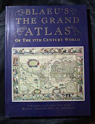
Grand Atlas of the Seventeenth Century World
Anbieter: WorldofBooks, Goring-By-Sea, WS, Vereinigtes Königreich
Verkäuferbewertung 5 von 5 Sternen

EUR 29,81
EUR 6,49 Versand
Versand von Vereinigtes Königreich nach USAAnzahl: 1 verfügbar
In den WarenkorbPaperback. Zustand: Very Good. The book has been read, but is in excellent condition. Pages are intact and not marred by notes or highlighting. The spine remains undamaged.
-
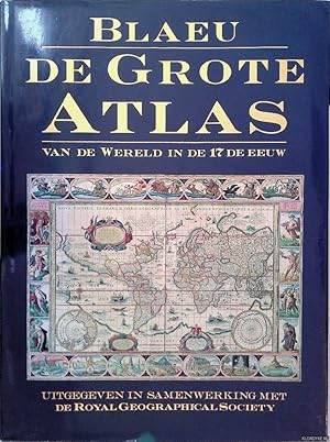
De grote atlas van de wereld in den 17de eeuw
Sprache: Niederländisch
Verlag: Lisse, Zuid Boekproducties, 1992
ISBN 10: 9062487386 ISBN 13: 9789062487387
Zustand: Good. Originele hardcover met goudopdruk op rug, stofomslag, veel grote afbeeldingen in kleur.
-
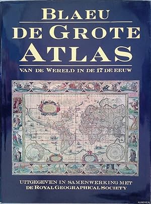
De grote atlas van de wereld in den 17de eeuw
Sprache: Niederländisch
Verlag: Lisse, Zuid Boekproducties, 1992
ISBN 10: 9062487386 ISBN 13: 9789062487387
Zustand: Good. Originele hardcover met goudopdruk op rug, stofomslag, veel grote afbeeldingen in kleur.
-

De grote atlas van de wereld in den 17de eeuw
Sprache: Niederländisch
Verlag: Lisse : Zuid Boekproducties, 1992
ISBN 10: 9062487386 ISBN 13: 9789062487387
Zustand: Good. Originele hardcover met goudopdruk op rug, stofomslag, veel grote afbeeldingen in kleur, groot 4to.; Voorkant stofomslag gevlekt.
-

De grote atlas van de wereld in de 17de eeuw
Sprache: Niederländisch
Verlag: Lisse : Rebo Productions, 1991
ISBN 10: 903660589X ISBN 13: 9789036605892
Zustand: Good. Originele blauwe hardcover met goudopdruk, grote kaarten in kleur, folio (circa 38x29cm). Uit de collectie van Peter van der Krogt (naamstempeltje op verso schutblad).; Klein scheurtje stofomslag geplakt.
-

First Edition. Fine cloth copy in a near fine, very slightly edge-nicked and dust-dulled dust wrapper, now mylar-sleeved. Remains particularly and surprisingly well-preserved; tight, bright, clean and sharp-cornered. Physical description; 1 atlas (224 pages) : color maps ; 37 cm. Notes; "The original maps . first appeared in Dr. Joan Blaeu's 'Atlas major, ' published in Amsterdam in 1662"--Title page verso. "Published in cooperation with the Royal Geographical Society, London." Includes bibliographical references (page 224). Introduction and commentary in English, maps in Latin. Subjects; Blaeu, Joan (1596-1673). Atlas maior. Atlases Early works to 1800 ; Facsimiles. Civilization, Modern 17th century ; Maps. Early maps ; Facsimiles. Cartography History. History of cartography ; [Literature]. Atlases. Cartography. Civilization, Modern. Early maps. Atlases Netherlands ; Early works to 1800 ; Facsimiles. Classical geography ; Maps. Geography, Ancient ; Maps. Historical geography ; Maps. Geography, Medieval ; Maps. Atlases, Dutch. History of cartography. ; [Literature] 1990. Atlases Netherlands. Atlases Netherlands ; Early works to 1800. World maps To 1800. Atlases ; Early works to 1800. World - ; Atlases 1662 (1997). Maps. Atlases. World. Atlases 17th century. Maps 17th century. World Facsimiles 1662 Atlases. Scales differ. Genres; cartographic image. Early works. Facsimiles. History. Maps. 1 Kg.
-

De grote atlas van de wereld in de 17de eeuw
Sprache: Niederländisch
Verlag: Lisse : Rebo Productions, 1991
ISBN 10: 903660589X ISBN 13: 9789036605892
Zustand: Good. Originele blauwe hardcover met goudopdruk, grote kaarten in kleur, folio.
-

Blaeu - Der grosse Atlas : die Welt im 17. Jahrhundert. Einführung, Texte und Auswahl der Karten von John Goss, ehemaliger Berater für Kartographie bei Sotheby`s ; Vorwort von Peter Clark, Konservator der Royal Geographical Society, London ; herausgegeben in Zusammenarbeit mit der Royal Geographical Society, London
Anbieter: Antiquariat J. Hünteler, Hamburg, Deutschland
Verbandsmitglied: GIAQ
Verkäuferbewertung 5 von 5 Sternen
Zustand: Gut. 224 Seiten, 39 cm, Mit zahlreichen farbigen Abbildungen, sauberes Exemplar. 208233_Atlanten Sprache: Englisch Gewicht in Gramm: 2560 Gr.-4°, Pappband mit Umschlag-O.
-

Blaeu - De Grote Atlas van de wereld in de 17de eeuw.
Sprache: Niederländisch
Verlag: Zuid Boekprodukties, Lisse, 1992
ISBN 10: 9062487386 ISBN 13: 9789062487387
Anbieter: Emile Kerssemakers ILAB, Heerlen, Niederlande
Verkäuferbewertung 5 von 5 Sternen
Hardcover with dust-jacket. 224 pp., many colour illustrations/ maps; 38.5x29 cm. Text in Dutch / Nederlands. (tear in dust-jacket, previous owner's name) Otherwise very good, see picture 2560g.
-

BLAEU'S THE GRAND ATLAS OF THE 17TH CENTURY WORLD.
Verlag: London, Studio, 1997., 1997
Anbieter: Grant's Bookshop, Cheltenham, VIC, Australien
Verkäuferbewertung 4 von 5 Sternen

c.224pp. Folio. Original cloth and dustwrapper, in near fine condition. Illustrated.
-
Blaeu. De grote atlas van de wereld in de 17e eeuw. Inleiding, aanvullende teksten en selectie van de kaarten: John Goss. [.]. Voorwoord: Peter Clark. [.].
Anbieter: Antiquariaat A. Kok & Zn. B.V., Amsterdam, Niederlande
Verkäuferbewertung 5 von 5 Sternen
[Lisse] Zuid Boekproducties, [1992]. 224 pp. Col. maps. orig. hardcover (blue cloth, gilt lettered on spine), d./j. Small folio.
-

Blaeu: de grote atlas van de wereld in de 17e eeuw
Sprache: Niederländisch
Verlag: Veltman Uitgevers B.V., 2000
ISBN 10: 9062489311 ISBN 13: 9789062489312
Anbieter: Mooney's bookstore, Den Helder, Niederlande
Verkäuferbewertung 4 von 5 Sternen
Zustand: Very good.
-
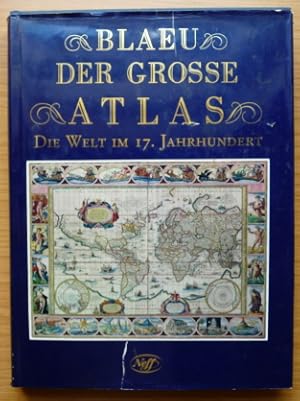
Blaeu - Der grosse Atlas: die Welt im 17. Jahrhundert. Einführung, Texte und Auswahl der Karten von John Goss, ehemaliger Berater für Kartographie bei Sotheby's ; Vorwort von Peter Clark, Konservator der Royal Geographical Society, London ; herausgegeben in Zusammenarbeit mit der Royal Geographical Society, London
Anbieter: Elops e.V. Offene Hände, Bad Windsheim, Deutschland
Verkäuferbewertung 5 von 5 Sternen
Festeinband, 39 cm. 224 S.; farbige Karten Schutzumschlag mit Läsuren und Einrissen; Einband bestoßen und gering lichtrandig Sprache: Deutsch Gewicht in Gramm: 2561.
-

Blaeu. De grote atlas van de wereld in de 17e eeuw.
Anbieter: Frans Melk Antiquariaat, HILVERSUM, Niederlande
Verkäuferbewertung 5 von 5 Sternen
Lisse, REBO, 1991. Folio. 37 x 29 cm. Gebonden met licht ongave stofomslag. Hardcover. Met illustraties in kleur. 224 pag. GOED EXEMPLAAR [Cartografie / Cartography ].
-
Ducatus Eboracensis Pars Orientalis; The Eastriding of Yorkeshire
Sprache: Englisch
Verlag: Blaeu, John, Amsterdam, 1648
Anbieter: K Books Ltd ABA ILAB, York, YORKS, Vereinigtes Königreich
Verbandsmitglied: ABA ILAB PBFA
Verkäuferbewertung 5 von 5 Sternen
EUR 596,58
EUR 22,59 Versand
Versand von Vereinigtes Königreich nach USAAnzahl: 1 verfügbar
In den WarenkorbNo Binding. Zustand: Very Good. Blaeu, John (illustrator). Beautifully engraved map, the detail derived from John Speed, showing towns, villages, wapentakes, woods, rivers etc. Very decorative, with 6 coats of arms of the Earls of Holderness in the top right. The title in an elaborate cartouche, bottom left. This printing is a reprint of Blaeu's map of 1645. Dutch text on verso, pagination 305 & 306, Register Qqqqq. Early hand colouring. Excellent condition, with fine wide margins. YAS No 97.
-
Eboracensis - Yorkshire
Sprache: Englisch
Verlag: Blaeu, John, Amsterdam, 1648
Anbieter: K Books Ltd ABA ILAB, York, YORKS, Vereinigtes Königreich
Verbandsmitglied: ABA ILAB PBFA
Verkäuferbewertung 5 von 5 Sternen
EUR 596,58
EUR 22,59 Versand
Versand von Vereinigtes Königreich nach USAAnzahl: 1 verfügbar
In den WarenkorbNo Binding. Zustand: Very Good. Blaeu, John (illustrator). Published by John Blaeu in 1648 (reprint of Blaeu's map of 1645 with French text on verso). Plate size 21.5 x 17 ins, 55 x 43 cms - engraved portion 18.75 x 14.5 ins, 48 x 37 cms. A rare copy of a map of Yorkshire, probably coloured early last century. A beautifully engraved map, the detail derived from that of John Speed - showing towns, villages, wapentakes, woods, rivers etc. Very decorative with 3 coats of Arms. The title in an elaborate cartouche and a scale decorated with a cherub. Excellent condition in double sided frame showing text on verso. Attractive and scarce. (Ref: Y.A.S. No. 95).
-
Eboracensis Pars Orientalis, - the East Riding of Yorkeshire
Sprache: Englisch
Verlag: Blaeu, John, Amsterdam, 1648
Anbieter: K Books Ltd ABA ILAB, York, YORKS, Vereinigtes Königreich
Verbandsmitglied: ABA ILAB PBFA
Verkäuferbewertung 5 von 5 Sternen
EUR 596,58
EUR 22,59 Versand
Versand von Vereinigtes Königreich nach USAAnzahl: 1 verfügbar
In den WarenkorbNo Binding. Zustand: Very Good. Blaeu, John (illustrator). Published by John Blaeu in 1648 (reprint of Blaeu's map of 1645 with French text on verso). Plate size 24 x 20 ins, 61 x 51 cms - engraved portion 19 x 14 ins, 48 x 36 cms. A rare copy of a map of the East Riding, probably coloured early last century. A beautifully engraved map, the detail derived from that of John Speed - showing towns, villages, wapentakes, woods, rivers etc. Very decorative with Arms of the Earl of Holderness, top right, and a sailing ship in the sea - bottom left, ornamental cartouche with title. Excellent condition. With fine wide margins. Attractive and scarce. (Ref: Y.A.S No. 95).
-
Blaeu's Atlas of England, Scotland, Wales and Ireland.
Verlag: London: Thames and Hudson, no date [1970]., 1970
Anbieter: Cornell Books Limited, Tewkesbury, Vereinigtes Königreich
Verbandsmitglied: PBFA
Verkäuferbewertung 5 von 5 Sternen
EUR 238,63
EUR 17,32 Versand
Versand von Vereinigtes Königreich nach USAAnzahl: 1 verfügbar
In den WarenkorbZustand: Near Fine. Facsimile of the 1645/1654 edition (hardback). Folio (53cm by 33cm), xvi, 103 double-page maps (mostly in b&w, although five are in colour), two colour plates (of Blaeu's title pages). Original two-tone cloth binding (red spine and corners, grey boards), grey card slipcase. The book is in very good condition; the slipcase is good to very good (repaired partial split to one edge). Limited to 500 copies, of which this is copy number 215. ISBN 050024071X.
-
![Bild des Verkäufers für [Portfolio]: Antique Maps of the World in Color zum Verkauf von Between the Covers-Rare Books, Inc. ABAA](https://pictures.abebooks.com/inventory/md/md31614799540.jpg)
[Portfolio]: Antique Maps of the World in Color
Verlag: Sterling Publishing House, Co., Inc, New York, 1960
Anbieter: Between the Covers-Rare Books, Inc. ABAA, Gloucester City, NJ, USA
Verbandsmitglied: ABAA ESA ILAB IOBA
Verkäuferbewertung 5 von 5 Sternen
Erstausgabe
Unbound. Zustand: Very Good. Portfolio. Color facsimiles of 36 historical maps. Each map measures approximately 12" x 9", printed on 17" x 11˝" paper with descriptive text in the left margin. Housed with a title page sheet and unprinted top sheet in a four-fold chemise. Unprinted topsheet sunned at the edges, first two leaves with some very light toning and a couple of tiny corner creases; the maps are otherwise bright and fine. The chemise is good only with toning, wear, and soil, and a 1" creased tear on the cover panel. A nice production, and the chemise has done its job, keeping the maps bright and fresh.
-
ORIGINAL ENGRAVED MAP OF ?BERKSHIRE BERCHERIA Barkshire?.
Verlag: 1648, 1648
Anbieter: PROCTOR / THE ANTIQUE MAP & BOOKSHOP, DORCHESTER, Vereinigtes Königreich
Verbandsmitglied: PBFA
Verkäuferbewertung 5 von 5 Sternen
Karte
EUR 256,53
EUR 23,17 Versand
Versand von Vereinigtes Königreich nach USAAnzahl: 1 verfügbar
In den WarenkorbLarge double sided map (engraved surface 19.5 x 15 inches). Gold tinted black hardwood Frame, with glass front & back. Frame Size 27 x 23.5 inches. Pleasing hand-colouring. An attractive and decorative map with elaborate title-cartouche and coats of arms. There is very light publishers centrefold. Strong impression. Overall in very good condition. Mount a little tanned, and in a wide black Hogarth frame, has some chipping. With DUTCH text on verso. One of the largest and most prolific map publishing houses of the 17th. century. The decorative merit and cartographic excellence of their maps are without doubt.
-
ORIGINAL ENGRAVED MAP OF Middlesex including London. Originally titled ?Middle-Sexia?.
Verlag: Amsterdam, John Blaeu, ca 1646, 1646
Anbieter: PROCTOR / THE ANTIQUE MAP & BOOKSHOP, DORCHESTER, Vereinigtes Königreich
Verbandsmitglied: PBFA
Verkäuferbewertung 5 von 5 Sternen
Karte
EUR 492,78
EUR 23,17 Versand
Versand von Vereinigtes Königreich nach USAAnzahl: 1 verfügbar
In den WarenkorbLarge map. Framed and mounted behind glass front and back. Frame size approx 23.5 x 23 inches. Engraved surface approx 16.5 x 16 inches. Later professional hand-colouring. An decorative map with elaborate title-cartouche. Latin text verso. In very good condition. With its Vertical centre fold. Glass on rear side has crack top to bottom. Later hand-colouring. This English county map of Middlesex is highly decorative with its figurative and allegoric title cartouche, as well the map is ornate with a heraldic family coat of arms. London is shown as miniature city view. On the map itsself are many placenames given, smaller villages or settlements also appear, also rivers, lakes, mountains and woods are also engraved. BLAEU, JOHN (1596 - 1673): One of the largest and most prolific map publishing houses of the 17th. century. The decorative merit and cartographic excellence of their maps are without doubt. `.
-
A Fine Composite Atlas.
Verlag: [Amsterdam: ca 1675]., 1675
Anbieter: Arader Galleries - AraderNYC, New York, NY, USA
Verkäuferbewertung 5 von 5 Sternen
Folio (21 x 13 inches). 42 fine double-page engraved maps, all mounted on guards, all with EXCEPTIONALLY FINE ORIGINAL HAND-COLOUR IN FULL HEIGHTENED IN GOLD (very small marginal tear to the map of Great Britain, just affecting the image). Contemporary reverse calf with maroon morocco lettering-piece on the spine: "Land Maps Vol. II" (a bit worn and stained, endpapers renewed). A bright and attractive atlas of mostly British and European maps, and probably compiled by a 17th-century English collector, and including a superb example of Visscher's "Orbis terrarum nova et accuratissima tabula" a fine double-hemisphere map with two smaller polar hemispheres in the cusps, surrounded by an allegorical border with grisaille colour wash heighlighted in gold; ". Septentrionalis ac Meridionalis Americae." by de Wit; "America Septentrionalis" and "Americae pars Meridionalis" by Jansson; "Insulae Americanae in Oceano Septentrionali ac regiones adiacentes" by Visscher; "Brasiliae" by Blaeu and a fine map of the South Pole by Blaeu. The majority of the maps are by de Wit (16), 11 are by Visscher, 10 are by Blaeu, 3 by Jansson, with one each by de Ram and Overton. Only one map is dated: 1659. Catalogued by Kate Hunter.
-

Aethiopia Superior vel Interior vulgo Abissinorum sive Presbiteri Joannis Imperium.
Erscheinungsdatum: 1635
Anbieter: Geographicus Rare Antique Maps, Brooklyn, NY, USA
Verbandsmitglied: ABAA ESA ILAB
Verkäuferbewertung 4 von 5 Sternen
Karte
Very good condition. Reinforced lower centerfold; printer's crease in upper right. Else excellent with a bold, sharp strike and generous margins. Size 15.25 x 19.75 Inches. This is the map of the mythical Kingdom of Prester John in eastern Africa, issued by Willem Blaeu in 1635, in a beautiful example. The map covers from the Bight of Benin to the Indian Ocean and from Arabia and the Red Sea to Mozambique. It includes two decorative cartouches, as well as stylized images of African fauna, including elephants, monkeys, and ostriches. While the African coast exhibits considerable advances over earlier maps of the region, the interior of Africa exhibits a cartography primarily based on the literature of antiquity and little changed from the days of Ptolemy, and its primary subject matter is that of legend. The Kingdom of Prester John This map frames the legendary Kingdom of Prester John (Presbiteri Ioannis) - a persistent and popular figure in European legend. The legend of Prester John dates to about 1145 when a Syrian priest named Hugh traveled to Europe to canvas for a Fifth Crusade. Hugh described Prester John as a great Christian king whose empire was located somewhere in India - the idea being that the two great Christian empires, that of John and that of the Pope, would together make war on the Saracens occupying the Holy Land, thus sandwiching the enemy between two indomitable armies. About 20 years later a curious letter began to circulate around Europe, purportedly by John himself, wherein the mythical King claimed to be some 562 years old and the ruler of the 'Three Indias'. 'India' at this time referred not just to the subcontinent, but much of southern Asia. It was divided into three parts, 'Farther India' or what is today India and Southeast Asia, 'Nearer India' or the modern-day Middle East, and 'Middle India' or the parts of Africa to the east of the Nile River. Having failed to pinpoint the Kingdom of Prester John in Asia, scholars as early as the 14th century began locating John's Kingdom in east Africa. Here they had a bit luck for explorers in the region, starting with the Francisco Alveres of Portugal in the 1500s, soon came into to contact with the Christian Solomonic Kings of Ethiopia or Abyssinia. The Coptic Ethiopian emperor David II fit the mold of the 'Prester John,' and Alveres believed him to be a descendent of the legendary John, thus firmly entrenching the mythical kingdom Prester John on maps of east Africa well into the 18th century. Abraham Ortelius committed the kingdom to a printed map in 1573, and his depiction of the kingdom remained sufficiently canonical for Blaeu to produce this modernized depiction of it using his own map of Africa for a framework. The Updated Map Cartographically this map is derived from Blaeu's own 1608 wall map of Africa one of the most important maps of the continent ever drawn. Most of the interior details offered here, notably the course and sources of the White Nile and its source in two great lakes, are derived from classical texts such as Ptolemy's Geographia. The Lake of Zaire (Zembre Lacus) and Lake Zaflan, themselves appear in the foothills of the Mountains of the Moon or Lunae Montes , located at the base of the map. The Blue Nile, which has its source is modern day Ethiopia, is expressed as a complex network of rivers and valleys bearing little resemblance to reality - although the observer will note that many of the place names, Amara, Tigre, Dobas, and Dangali, do in fact reflect real places and are still in use today. Blaeu also draws a lake at the source of the Niger River, set just north of the West African Kingdom of Biafara, but fails to properly connect the river to its southern extension - which is vaguely noted. Blaeu's place names relating to Prester John's kingdom and the multiplicity of rivers to the east of the Upper Nile are derived from Ortelius' 1571 map focusing on the same theme: an instance of the cartographic authority of his own gen.


