
Gesamtpreis (1 Artikel Artikel):
Versandziel:

world map title (14 Ergebnisse)
Direkt zu den wichtigsten Suchergebnissen
Suchfilter
Produktart
- Alle Product Types
- Bücher (2)
- Magazine & Zeitschriften (Keine weiteren Ergebnisse entsprechen dieser Verfeinerung)
- Comics (Keine weiteren Ergebnisse entsprechen dieser Verfeinerung)
- Noten (Keine weiteren Ergebnisse entsprechen dieser Verfeinerung)
- Kunst, Grafik & Poster (2)
- Fotografien (Keine weiteren Ergebnisse entsprechen dieser Verfeinerung)
- Karten (10)
- Manuskripte & Papierantiquitäten (Keine weiteren Ergebnisse entsprechen dieser Verfeinerung)
Zustand Mehr dazu
- Neu (Keine weiteren Ergebnisse entsprechen dieser Verfeinerung)
- Wie Neu, Sehr Gut oder Gut Bis Sehr Gut (3)
- Gut oder Befriedigend (2)
- Ausreichend oder Schlecht (Keine weiteren Ergebnisse entsprechen dieser Verfeinerung)
- Wie beschrieben (9)
Einband
- alle Einbände
- Hardcover (1)
- Softcover (Keine weiteren Ergebnisse entsprechen dieser Verfeinerung)
Weitere Eigenschaften
- Erstausgabe (Keine weiteren Ergebnisse entsprechen dieser Verfeinerung)
- Signiert (Keine weiteren Ergebnisse entsprechen dieser Verfeinerung)
- Schutzumschlag (Keine weiteren Ergebnisse entsprechen dieser Verfeinerung)
- Angebotsfoto (14)
Sprache (2)
Preis
- Beliebiger Preis
- Weniger als EUR 20 (Keine weiteren Ergebnisse entsprechen dieser Verfeinerung)
- EUR 20 bis EUR 45 (Keine weiteren Ergebnisse entsprechen dieser Verfeinerung)
- Mehr als EUR 45
Gratisversand
- Kostenloser Versand nach USA (Keine weiteren Ergebnisse entsprechen dieser Verfeinerung)
Land des Verkäufers
Verkäuferbewertung
-
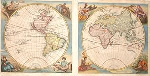
Atlas de la navigation, Renard Louis, Ottens 1739, old colours, complete Renard, Louis, Atlas de la navigation, et du commerce qui se fait dans toutes les parties du monde . Revű & corrigé sur les nouvelles observations. Second edition of this superb see-atlas, a reissue of the first edition of 1715 with a few minor alterations and the address of Reinier and Josua Ottens on the title-page. With engraved frontispiece of Atlas supporting a planispherical world map, engraved title vignette, portrait of George I by Picart, headpiece and initial opening dedication, 28 double-page engr. maps (one folding), all in fine contemp. coloring, and 4 uncolored folding copper plates of fortification plans. 20th cent. red morocco on raised gilt bands and
Sprache: Französisch
Erscheinungsdatum: 1739
Anbieter: Hammelburger Antiquariat, Hammelburg, Deutschland
Verkäuferbewertung 5 von 5 Sternen

EUR 70.000,00
EUR 30,00 Versand
Versand von Deutschland nach USAAnzahl: 1 verfügbar
In den WarenkorbHardcover. Zustand: Sehr gut. Atlas de la navigation, Renard Louis, Ottens 1739, old colours, complete Renard, Louis, Atlas de la navigation, et du commerce qui se fait dans toutes les parties du monde . Revű & corrigé sur les nouvelles observations. Second edition of this superb see-atlas, a reissue of the first edition of 1715 with a few minor alterations and the address of Reinier and Josua Ottens on the title-page. With engraved frontispiece of Atlas supporting a planispherical world map, engraved title vignette, portrait of George I by Picart, headpiece and initial opening dedication, 28 double-page engr. maps (one folding), all in fine contemp. coloring, and 4 uncolored folding copper plates of fortification plans. 20th cent. red morocco on raised gilt bands and 2 labels on spine. - Text leaves partly browned (plates not affected), few maps in outer lower margin with slight crease, frontisp. slightly fingerstained, front flying endpaper with crease. Few small scratches to binding. Well-preserved and fine copy with broad untrimmed margins. Zweite Ausgabe, vollständig, in herrlichem Altkolorit. Mit gest. Frontispiz (planisphärische Weltkarte, von Atlas getragen), gest. Titelvignette, gest. Porträt Georgs I. von Großbritannien von B. Picart, gest. Kopfvignette, gest. Initiale und 28 doppelblattgr. Karten (davon 1 gefalt.), sämtlich in prächtigem Altkolorit . Ferner mit 4 gefalt. gest. Fortifikationstafeln . Amsterdam, R. und J. Ottens 1739. Roter Maroquin des früh. 20. Jhs. auf 5 goldgepr. Bünden mit dopp. farb. RSch. 57 : 36 cm. 3 Bll., 96 S. Zweite Ausgabe des hervorragenden und prachtvollen Seeatlas, ein Nachdruck der ersten Ausgabe von 1715 mit neuer Verlagsadresse auf dem Titel, die Tafeln und Karten tragen noch die Adresse von Louis Renard aus der ersten Ausgabe; Karte Nr. 6 (Norvegiae maritimae ) wurde laut Koeman etwas überarbeitet. 1745 erschien noch eine dritte, komplett revidierte Ausgabe in Niederländisch. "This continuous revision proves that the atlas was intended for use at sea and not only for the consultation on shore" (Koeman). Renards Atlas basiert auf den Seekarten von Frederik de Wit, wobei jede Karte gründlich korrigiert und revidiert wurde. Die sehr schönen Bildkartuschen bzw. Bildeinfassungen sind durchweg radiert und stammen vermutlich von Romeyn de Hooghe . Die meist detailreichen Szenen zeigen Walfang, Bärenjagd, Elfenbeinhandel, Indianer, Porträt Magellans, Trachten und Tiere der jeweiligen Regionen etc. Sämtliche Karten in ausgezeichnetem Druck und frischem Kolorit . Neben der schönen Weltkarte und einer Polkarte sind Seekarten folgender Länder enthalten: Europa, Nowaja Semla, Lappland, Norwegen, Ostsee, Dänemark, Nordsee mit Großbritannien, Ärmelkanal-Themsemündung, Ärmelkanal, Mittelmeer in 2 Teilen, Schwarzes Meer und Krim, Küsten Afrikas in drei Teilen, Arabisches Meer, Insulinde, Pazifik, Feuerland, Brasilien, Atlantik mit Neufundland und Teilküste Nordamerikas, Karibik, Labrador und Hudsonbay. - Die vier unkolorierten Faltkupfer am Ende zeigen Fortifikationspläne mit ausführl. Erläuterungen. - Textbll. tlw. gebräunt (Tafeln nicht betroffen), wenige Karten am äußeren unt. Rand mit leichter Knickspur, Frontisp. im Rand leicht fleckig, vord. flieg. Vorsatz mit Knickspur. Einbd. mit wenigen kl. Kratzspuren. Insgesamt sehr gutes, breitrandiges und unbeschnittenes Exemplar (tls. mit Schöpfrändern). Koemann IV, Ren 2. - Phillips 602. - NMM III, 265. - Shirley 444 (Abb. der Weltkarte).
-

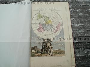
INTRODUCTION A LA GEOGRAPHIE. . Title page with small simple double hemisphere world map, showing California as an island.
Verlag: N. de Fer in Paris 1717, 1717
Anbieter: Garwood & Voigt, Sevenoaks, Vereinigtes Königreich
Verkäuferbewertung 5 von 5 Sternen
Karte
EUR 107,33
EUR 34,74 Versand
Versand von Vereinigtes Königreich nach USAAnzahl: 1 verfügbar
In den WarenkorbNo Binding. Zustand: Fine. 19x10cm. Uncoloured. Excellent condition.
-
no title- World map
Verlag: Artist: Happel Eberhard Werner ( - 1690 ) Hamburg : 1684, 1647
Anbieter: Antique Sommer& Sapunaru KG, München, Deutschland
Verkäuferbewertung 3 von 5 Sternen

EUR 3.650,00
EUR 45,00 Versand
Versand von Deutschland nach USAAnzahl: 1 verfügbar
In den WarenkorbTechnic: Copper print, colorit: original colored, condition: Upper external right corner perfectly restored, size (in cm): 29,5 x 60,5 cm, Magnificent, rare map of the world in 2 hemispheres and printed on two plates, surrounded by allegorical representations for the continents Asia, Europe, America and Africa. Engraved by Henricus Irnsingerus.
-

WORLD MAP 1859 by Adolf Stieler Title: Westliche Oestliche Halbkugel
Verlag: Verlag Justus Perthes, Gotha, 1859
Anbieter: ANTIQUARIAT.WIEN Fine Books & Prints, Wien, Österreich
Verkäuferbewertung 5 von 5 Sternen
Karte
original map, original steelengraving, old colours, / original Landkarte, original Stahlstich alt teilkoloriert, Format ca. 18 x 26 cm, etwas knapp beschnitten de 500 Landkarte.
-
![Bild des Verkäufers für WORLD MAP by. J Russell [date 1818] Title: Chart of the World, from the best Authorities zum Verkauf von ANTIQUARIAT.WIEN Fine Books & Prints](https://pictures.abebooks.com/inventory/md/md30530735687.jpg)
WORLD MAP by. J Russell [date 1818] Title: Chart of the World, from the best Authorities
Verlag: London, 1818
Anbieter: ANTIQUARIAT.WIEN Fine Books & Prints, Wien, Österreich
Verkäuferbewertung 5 von 5 Sternen
Karte
original copper engraving, Image Format ca. 19 x 30 cm de 500 Landkarte.
-
![Bild des Verkäufers für HISTORICAL MAP OF THE OLD WORLD, Map [date 1852] by J.D. Barbie du Bocage and Doufour Title: Monde Connu des Anciens. zum Verkauf von ANTIQUARIAT.WIEN Fine Books & Prints](https://pictures.abebooks.com/inventory/md/md30530741248.jpg)
HISTORICAL MAP OF THE OLD WORLD, Map [date 1852] by J.D. Barbie du Bocage and Doufour Title: Monde Connu des Anciens.
Verlag: Maison Basse, Paris, 1852
Anbieter: ANTIQUARIAT.WIEN Fine Books & Prints, Wien, Österreich
Verkäuferbewertung 5 von 5 Sternen
Karte
original map, original steelengraving, old colours, / original Landkarte, original Stahlstich alt teilkoloriert, Format ca. 19 x 27 cm de 500 Landkarte.
-

HISTORICAL MAP OF THE OLD WORLD, MAP ca. 1850 by Alexandre Vuillemin Title: Monde Connu des Anciens.
Verlag: ca. 1850, [Paris], 1850
Anbieter: ANTIQUARIAT.WIEN Fine Books & Prints, Wien, Österreich
Verkäuferbewertung 5 von 5 Sternen
Karte
original map, original steelengraving, old colours, / original Landkarte, original Stahlstich alt teilkoloriert, Blattformat ca. 18 x 25 cm de 500 Landkarte.
-

WORLD MAP 1817 Title The world on Mercators projection
Verlag: A. Constable, Edinburgh, 1817
Anbieter: ANTIQUARIAT.WIEN Fine Books & Prints, Wien, Österreich
Verkäuferbewertung 5 von 5 Sternen
Karte
original map, original steelengraving, / original Landkarte, original Stahlstich Format ca. 19,5 x 25 cm de 500 Landkarte.
-

WORLD MAP, 1851 by. John Rapkin Title The world on Mercators projection / the map drawn & engraved by J. Rapkin ; the illustrations by H. Warren & engraved by J.B. Allen
Verlag: John Tallis [1851], London, 1851
Anbieter: ANTIQUARIAT.WIEN Fine Books & Prints, Wien, Österreich
Verkäuferbewertung 5 von 5 Sternen
Karte
original steel engraving, Image Format ca. 23,5 x 32,5 cm de 500 Landkarte.
-

WORLD MAP AIR 1842 BERGHAUS Title: Geographical distribution of the currents of air or of the perennial periodical and variable winds : shewing also the various regions of prevalent hurricanes / by Dr. Heinrich Karl Wilhelm Berghaus(1797-1884), Professor of Geography Berlin ; engraved by W. & A.K. Johnston ; drawn in the Engravers School for Geography, Potsdam, Decr. 1842
Verlag: John Johnstone and W. & A.K. Johnston / : Robert Weir - Lumsden & Son, Edinburgh / Glasgow, 1842
Anbieter: ANTIQUARIAT.WIEN Fine Books & Prints, Wien, Österreich
Verkäuferbewertung 5 von 5 Sternen
Karte
colored engraved map, format 48 x 58 cm, a very good copy ORIGINAL MAP /ORIGINALE LANDKARTE de 500 Buch.
-
Americae Sive Novi Orbis, anno 1603, Ortelius Abraham, copperengraving, original Title: AMERICAE SIVE | NOVI ORBIS, NO:|VA DESCRIPTIO. [A new description of America or the New World]. (lower right corner:) "Cum Priuilegio decennali. | Ab. Ortelius delineab. | et excudeb. 1587". [With a privilege for ten years. Abraham Ortelius drew and executed [this map] in 1587]. NOVA GUINEA. "Andre:|as Corsalus Florent. videtur eam | sub nomine Terrć Picceinnacoli | designare". [New Guinea. Andreas Corsalis from Florence seems to designate the name Terra Picennacoli to it.] TERRA AVSTRA|LIS, SIVE | MAGELLA:|NICA HAC:|TENVS INCOGNITA. [The Southern or Magellanican land, as yet unknown.] (Left top:) "Vlterius Septentrionem versus hć | regiones i
Erscheinungsdatum: 1603
Anbieter: Hammelburger Antiquariat, Hammelburg, Deutschland
Verkäuferbewertung 5 von 5 Sternen
Kunst / Grafik / Poster
EUR 5.900,00
EUR 30,00 Versand
Versand von Deutschland nach USAAnzahl: 1 verfügbar
In den WarenkorbKein Einband. Zustand: Gut. Americae Sive Novi Orbis, anno 1603, Ortelius Abraham, copperengraving, original Title: AMERICAE SIVE | NOVI ORBIS, NO:|VA DESCRIPTIO. [A new description of America or the New World]. (lower right corner:) "Cum Priuilegio decennali. | Ab. Ortelius delineab. | et excudeb. 1587". [With a privilege for ten years. Abraham Ortelius drew and executed [this map] in 1587]. NOVA GUINEA. "Andre:|as Corsalus Florent. videtur eam | sub nomine Terrć Picceinnacoli | designare". [New Guinea. Andreas Corsalis from Florence seems to designate the name Terra Picennacoli to it.] TERRA AVSTRA|LIS, SIVE | MAGELLA:|NICA HAC:|TENVS INCOGNITA. [The Southern or Magellanican land, as yet unknown.] (Left top:) "Vlterius Septentrionem versus hć | regiones incognitć adhuc sunt". [Further towards the North, these regions are as yet unknown.] (Centre:) "Hic vspiam insulas | eße, auro diuites | nonnulli volunt" [Some have it that somewhere here there are islands rich in gold.] (Lower right:) PATAGONES, | "vel" | REGIO GI:|GANTVM [The Patagonians, or the region of giants.] (Low right:) "Arx posita hic 1582. ex man. R.M. | C. 11000 virginum" [A fortress was built here in 1582 by hand by his Royal Majesty, for 11000 nuns.] (Middle right:) "Porto Real ad quem | Galli mercatum|nauigant". [Porto Real, to which the French merchants sail.] (Middle right:) "Rio Maragnone | cuius ostium distat | ab ostio Amazonis | flu. 104 leucis teste | Theueto." [The river Maranhao, whose mouths are at a distance of 104 miles from the mouth of the river Amazon, as Thevet says.] (Centre right:) BRESILIA | "ŕ Lusitanis Ao. | 1504. | inuenta" [Brazil, discovered by the Portuguese in the year 1504.] Plate size: 354 x 484 mm Identification number: Ort 11 (van den Broecke) Good print wide margins, no cracs or tears.
-

RIVER MAP - A graphic comparison of the longest rivers on earth Title: Plan of the lengths of the Principal Rivers throughout the World. (from Thomson's New General Atlas)
Verlag: [John Thomson & Co] ca. 1821, [Edinburgh], 1821
Anbieter: ANTIQUARIAT.WIEN Fine Books & Prints, Wien, Österreich
Verkäuferbewertung 5 von 5 Sternen
Karte
original engraved map partly coloured, ca. 71 x 54 cm, Scale of Miles , good Tooley IV, 271 en 500 Buch.
-
World map without title
Verlag: 1618, 1618
Anbieter: Antiquariaat Dat Narrenschip, Middelburg, Niederlande
Verkäuferbewertung 5 von 5 Sternen
Karte
No Binding. Zustand: Fine. World map in two hemispheres without title. The map shows the voyage around the world in 1615-1617 under commander Jacob le Maire and skipper Willem Cornelis Schouten. Above the map two portraits of Ferdinand Magellaan (left) and Willem Cornelis Schouten (right), each flanked by an angel with a laurel wreath. In the upper corners the two ships of the expedition, on the left the Victoria and on the right the Eendracht (Schouten's ship). The map is flanked on the left and right by portraits of four other explorers: Francis Drake and Olivier van Noort (left) and Thomas Cavendish and Joris van Spilbergen on the right. Copper engraving, published in or shortly after 1618. Great piece with a beautiful, early and powerful impression. Dimensions (image): 16 x 23 cm.
-
Marseille, anno 1740, very big map by Probst G.B. Panoramic town-view of Marseille, engraved by Johan Fridrich Leizel. With the title in a banderol at the head, flanked on the left by the crowned city arms in a cartouche. With a key to 33 numbered buildings, etc. in Latin, German and French. After a design by Friedrich Bernhard Werner (1690-1776) who was born in Silesia. Size of the leaf: 40x110 cm., printed on two joined leaves. very good condition, only small, not remarkable 2-3 tears on margins. Reference: Fauser, Nr. 8574 Georg Balthasar Probst (1673-1748) was a german engraver and publisher in Augsburg, located in Germany. He produced architectural views of places around the world intended as vues d'optiques, which were published in v
Erscheinungsdatum: 1740
Anbieter: Hammelburger Antiquariat, Hammelburg, Deutschland
Verkäuferbewertung 5 von 5 Sternen
Kunst / Grafik / Poster
EUR 2.490,00
EUR 30,00 Versand
Versand von Deutschland nach USAAnzahl: 1 verfügbar
In den WarenkorbKein Einband. Zustand: Gut. Marseille, anno 1740, very big map by Probst G.B. Panoramic town-view of Marseille, engraved by Johan Fridrich Leizel. With the title in a banderol at the head, flanked on the left by the crowned city arms in a cartouche. With a key to 33 numbered buildings, etc. in Latin, German and French. After a design by Friedrich Bernhard Werner (1690-1776) who was born in Silesia. Size of the leaf: 40x110 cm., printed on two joined leaves. very good condition, only small, not remarkable 2-3 tears on margins. Reference: Fauser, Nr. 8574 Georg Balthasar Probst (1673-1748) was a german engraver and publisher in Augsburg, located in Germany. He produced architectural views of places around the world intended as vues d'optiques, which were published in various places during the last half of the 18th century, including Paris, Augsburg and London. He was also known for his portraits. Probst came from an extended family of printers, whose businesses can all be traced back to the publishing firm of Jeremias Wolff (1663-1724). After Wolff's death his firm was continued as "Wolff's Heirs" (Haeres Jer. Wolffii) by his son-in-law Johann Balthasar Probst (1689-1750). After Probst's death in 1750, his descendants divided the business and published under their own imprints: Johann Friedrich Probst (1721-1781), Georg Balthasar Probst (1732-1801) and Johann Michael Probst. Another part of the Wolff-Probst firm was acquired by the Augsburg publisher Johann Georg Hertel (1700-1775), whose son Georg Leopold Hertel had married a sister of the Probsts. In the next generation, Georg Mathäus Probst (d. 1788), son of Georg Balthasar Probst, also became an engraver of portraits and views.
![Bild des Verkäufers für Americae Sive Novi Orbis, anno 1603, Ortelius Abraham, copperengraving, original Title: AMERICAE SIVE | NOVI ORBIS, NO:|VA DESCRIPTIO. [A new description of America or the New World]. (lower right corner:) "Cum Priuilegio decennali. | Ab. Ortelius delineab. | et excudeb. 1587". [With a privilege for ten years. Abraham Ortelius drew and executed [this map] in 1587]. NOVA GUINEA. "Andre:|as Corsalus Florent. videtur eam | sub nomine Terrć Picceinnacoli | designare". [New Guinea. Andreas Corsalis from Florence seems to designate the name Terra Picennacoli to it.] TERRA AVSTRA|LIS, SIVE | MAGELLA:|NICA HAC:|TENVS INCOGNITA. [The Southern or Magellanican land, as yet unknown.] (Left top:) "Vlterius Septentrionem versus hć | regiones i zum Verkauf von Hammelburger Antiquariat](https://pictures.abebooks.com/inventory/md/md32120286247.jpg)

