Gesamtpreis (1 Artikel Artikel):
Versandziel:

typus orbis terrarum (35 Ergebnisse)
Direkt zu den wichtigsten Suchergebnissen
Suchfilter
Produktart
- Alle Product Types
- Bücher (11)
- Magazine & Zeitschriften (Keine weiteren Ergebnisse entsprechen dieser Verfeinerung)
- Comics (Keine weiteren Ergebnisse entsprechen dieser Verfeinerung)
- Noten (Keine weiteren Ergebnisse entsprechen dieser Verfeinerung)
- Kunst, Grafik & Poster (3)
- Fotografien (Keine weiteren Ergebnisse entsprechen dieser Verfeinerung)
- Karten (21)
- Manuskripte & Papierantiquitäten (Keine weiteren Ergebnisse entsprechen dieser Verfeinerung)
Zustand Mehr dazu
- Neu (1)
- Wie Neu, Sehr Gut oder Gut Bis Sehr Gut (3)
- Gut oder Befriedigend (4)
- Ausreichend oder Schlecht (Keine weiteren Ergebnisse entsprechen dieser Verfeinerung)
- Wie beschrieben (27)
Einband
- alle Einbände
- Hardcover (Keine weiteren Ergebnisse entsprechen dieser Verfeinerung)
- Softcover (1)
Weitere Eigenschaften
- Erstausgabe (4)
- Signiert (Keine weiteren Ergebnisse entsprechen dieser Verfeinerung)
- Schutzumschlag (Keine weiteren Ergebnisse entsprechen dieser Verfeinerung)
- Angebotsfoto (29)
Sprache (3)
Gratisversand
Land des Verkäufers
Verkäuferbewertung
-

"La Mans Cenomano Rum Typus" - Maine Le Mans / France Frankreich / carte map Karte / Epitome du theatre du monde / Theatro del Mondo / Theatrum orbis terrarum
Sprache: Französisch
Verlag: Antwerp, Plantin for Philippe Galle, 1598
Anbieter: Antiquariat Steffen Völkel GmbH, Seubersdorf, Deutschland
Verkäuferbewertung 5 von 5 Sternen

Karte
Seltene Kupferstich-Karte von Abraham Ortelius von 1598. Mit französischem Text auf der Rückseite. -- Bildmaße: ca. 7,8 x 11 cm. -- etwas fleckig im rechten Außenrand, sonst gut erhalten. || Rare map by Abraham Ortelius from 1598. With French text verso. -- somewhat stained in the right margin, otherwise in very good condition. // Wir, das Antiquariat Steffen Völkel, kaufen und verkaufen alte Bücher, Handschriften, Zeichnungen, Autographen, Grafiken und Fotografien. Wir sind stets am Ankauf von kompletten Bibliotheken, Sammlungen und Nachlässen interessiert. Sprache: Französisch Gewicht in Gramm: 10.
-

Lamina: Typus orbis Terrarum
Anbieter: El Boletin, Barcelona, B, Spanien
Verkäuferbewertung 5 von 5 Sternen
medida 35,5 x 24 cm, papel apergaminado, ignoramos editor y ańo , para enmarcar.
-

"Carthagin. Portus / Carthaginis celeberrimi sinus typus" - Cartage Tunisia Tunesien Tunis Africa Afrika Afrique / carte map Karte / Epitome du theatre du monde / Theatro del Mondo / Theatrum orbis terrarum
Sprache: Französisch
Verlag: Antwerp, Plantin for Philippe Galle, 1598
Anbieter: Antiquariat Steffen Völkel GmbH, Seubersdorf, Deutschland
Verkäuferbewertung 5 von 5 Sternen
Karte
Seltene Kupferstich-Karte von Abraham Ortelius von 1598. Mit französischem Text auf der Rückseite. -- Bildmaße: ca. 7,8 x 11 cm. -- gut erhalten. || Rare map by Abraham Ortelius from 1598. With French text verso. -- in very good condition. // Wir, das Antiquariat Steffen Völkel, kaufen und verkaufen alte Bücher, Handschriften, Zeichnungen, Autographen, Grafiken und Fotografien. Wir sind stets am Ankauf von kompletten Bibliotheken, Sammlungen und Nachlässen interessiert. Sprache: Französisch Gewicht in Gramm: 10.
-

"Lotharingia / Lotharingiae Typus" - Lothringen Lorraine Nancy Metz / France Frankreich / carte map Karte / Epitome du theatre du monde / Theatro del Mondo / Theatrum orbis terrarum
Sprache: Französisch
Verlag: Antwerp, Plantin for Philippe Galle, 1598
Anbieter: Antiquariat Steffen Völkel GmbH, Seubersdorf, Deutschland
Verkäuferbewertung 5 von 5 Sternen
Karte
Seltene Kupferstich-Karte von Abraham Ortelius von 1598. Mit französischem Text auf der Rückseite. -- Bildmaße: ca. 7,8 x 11 cm. -- gut erhalten. || Rare map by Abraham Ortelius from 1598. With French text verso. -- in very good condition. // Wir, das Antiquariat Steffen Völkel, kaufen und verkaufen alte Bücher, Handschriften, Zeichnungen, Autographen, Grafiken und Fotografien. Wir sind stets am Ankauf von kompletten Bibliotheken, Sammlungen und Nachlässen interessiert. Sprache: Französisch Gewicht in Gramm: 10.
-

Buchaviae, sive Fuldensis Ditionis Typus. - Frühe altkolorierte Holzschnittkarte der Diözese Fulda aus Ortelius Theatrum Orbis Terrarum.
Sprache: Deutsch
Verlag: Abraham Ortelius, Antwerpen, 1574
Anbieter: Antiquariat und Verlag Gerhard Henrich, Langenbieber, Deutschland
Verkäuferbewertung 5 von 5 Sternen
Kunst / Grafik / Poster
Softcover. Zustand: Gut. Aufwändigst gerahmter und passepartourierter Druck,
-

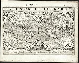
"Typus Orbis Terrarum" - World map Weltkarte Mappemonde carte
Sprache: Französisch
Verlag: Amsterdam, J. Hondius, 1618
Anbieter: Antiquariat Steffen Völkel GmbH, Seubersdorf, Deutschland
Verkäuferbewertung 5 von 5 Sternen
Karte Erstausgabe
Kupferstich-Karte aus der ersten französischen Ausgabe von Bertius' "Atlas Minor" gedruckt in Amsterdam bei J. Hondius im Jahre 1618. Mit französischem Text auf der Rückseite. -- Maße: ca. 9,5 x 13,5 cm. -- teils nur leicht tintenfleckig, sonst gut erhalten. || Copper engraved map out of the first French edition of Bertius' "Atlas Minor", published by J. Hondius in Amsterdam in 1618. With French text on verso. -- only slightly stained from ink, otherwise in good condition. // Wir, das Antiquariat Steffen Völkel, kaufen und verkaufen alte Bücher, Handschriften, Zeichnungen, Autographen, Grafiken und Fotografien. Wir sind stets am Ankauf von kompletten Bibliotheken, Sammlungen und Nachlässen interessiert. Sprache: Französisch Gewicht in Gramm: 10.
-

"Typus Orbis Terrarum" - World map Weltkarte Mappemonde
Sprache: Französisch
Verlag: Amsterdam, J. Hondius, 1618
Anbieter: Antiquariat Steffen Völkel GmbH, Seubersdorf, Deutschland
Verkäuferbewertung 5 von 5 Sternen
Karte Erstausgabe
Original Kupferstich-Karte aus der ersten französischen Ausgabe von Bertius' "Atlas Minor" gedruckt in Amsterdam bei J. Hondius im Jahre 1618. Mit französischem Text auf der Rückseite. -- Blatt-Maße: ca. 12 x 17,5 cm. -- am linken Plattenrand teils leicht hinterlegt, am unteren Außenrand teils leicht fleckig, sonst gut erhalten. || Original engraved map out of the first French edition of Bertius' "Atlas Minor", published by J. Hondius in Amsterdam in 1618. With French text on verso. -- slightly stained on the lower outer margin, deposited on the left plate margin, otherwise in good condition. // Wir, das Antiquariat Steffen Völkel, kaufen und verkaufen alte Bücher, Handschriften, Zeichnungen, Autographen, Grafiken und Fotografien. Wir sind stets am Ankauf von kompletten Bibliotheken, Sammlungen und Nachlässen interessiert. Sprache: Französisch Gewicht in Gramm: 10.
-

"Typus Orbis Terrarum Description de la Terre Universelle" - World Map Weltkarte Mappemonde
Sprache: Französisch
Verlag: Paris, Jollain, 1659
Anbieter: Antiquariat Steffen Völkel GmbH, Seubersdorf, Deutschland
Verkäuferbewertung 5 von 5 Sternen
Karte
Rare map by Jean Boisseau from his rare Atlas "Tresor des Cartes Geographiques", first published in 1643, which was the first French World Atlas. -- Size of sheet: c. 17 x 23 cm. -- with some restored tears, the right upper corner backed, otherwise in good condition. || Seltene Karte von Jean Boisseau aus seinem seltenen Atlas "Tresor des Cartes Geographiques", der erstmals 1643 veröffentlicht wurde. Dies war der erste französische Weltatlas. -- mit restaurierten Einrissen, rechte obere Außenecke angerändert, sonst gut erhalten. || Dies ist ein Original! - Kein Nachdruck! - Keine Kopie! -- This is an original! - No copy! - No reprint! // Wir, das Antiquariat Steffen Völkel, kaufen und verkaufen alte Bücher, Handschriften, Zeichnungen, Autographen, Grafiken und Fotografien. Wir sind stets am Ankauf von kompletten Bibliotheken, Sammlungen und Nachlässen interessiert. Sprache: Französisch Gewicht in Gramm: 10.
-

Kolorierte Kupferstich-Landkarte bei Christoph Weigel. Orbis terrarum veteribus cogntiti typus ad mentem veterum geographorum.
Verlag: Nürnberg, Weigel, um 1750., 1750
Anbieter: Antiquariat Thomas Rezek, München, Deutschland
Verkäuferbewertung 5 von 5 Sternen
Kunst / Grafik / Poster
circa 35,2 x 37,4 cm. 1 Doppelblatt mittig geglättete Falte Karte der Welt soweit sie in der Antike bekannt war mit Europa, Asien und Afrika. - Etwas gebräunt, leicht fleckig, am Mittelfalz mit etwas durchscheinendem Leimschatten.
-

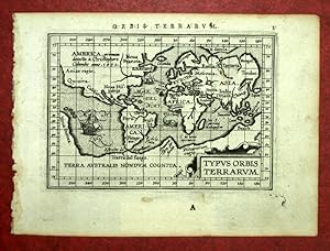
Typus Orbis Terrarum
Verlag: Wolfenbüttel, 1661
Anbieter: Antikvariat Krenek, Prag, Tschechien
Verbandsmitglied: ILAB
Verkäuferbewertung 5 von 5 Sternen
The World."Typus Orbis Terrarum". Orig. copperplate engraving, 1661. P. Cluver's map of the World. Published in Wolfenbüttel by J. Buno, 1661. With title at the top. 15,5:30,2 cm (6 1/4 x 12 inch.). Shirley: The Mapping of the World, map 425. - A map of the World in two hemispheres. - Upper margin cutted to the desk (not affecting the picture).
-

Typus Orbis Terrarum
Verlag: Hondius, J., Amsterdam, 1616
Anbieter: Antikvariat Krenek, Prag, Tschechien
Verbandsmitglied: ILAB
Verkäuferbewertung 5 von 5 Sternen
The World."Typus Orbis Terrarum". Orig. copperplate engraving, P. Bertius. Published by J. Hondius Jun. in Amsterdam, 1616/18. With latin title above the map ("Descriptio Orbis Nostra"), title-cartouche and ornamental margins. 9,5:13,5 cm (3 3/4 x 5 1/4 inch.). Shirley: The Mapping of the World, map 290; Koeman III, map 0001:342A, ed. 342:01 (1616/1618 Tabulae). - A miniature map of the World in Mercator projection (oval). With the motto "Domini Est Terra Et Plenitudo Eius" in a cartouche at the bottom.
-

Typus Orbis Terrarum
Verlag: Hondius, Jodocus Jr., Amsterdam, 1618
Anbieter: Antikvariat Krenek, Prag, Tschechien
Verbandsmitglied: ILAB
Verkäuferbewertung 5 von 5 Sternen
The World."Typus Orbis Terrarum". Orig. copperplate engraving after J. Hondius' map. From P. Bertius' "Tabulae Geographicae .". Published in Amsterdam by J. Hondius Jr., 1616/18. A map of the World in 2 hemispheres. With title at the top and Hondius' name at the bottom and Latin title ("De Globo Terrae") above the map. 9,5:13,5 cm (3 3/4 x 5 1/4 inch.). Shirley: The Mapping of the World, map 291; Koeman III, map 0001:342B, ed. 342:01 (1616/18 Tabulae). - A miniature map of the World.
-

Orbis Terrarum Typus
Verlag: Artist: Anonymus ca :, 1700
Anbieter: Antique Sommer& Sapunaru KG, München, Deutschland
Verkäuferbewertung 4 von 5 Sternen

Technic: Copper print, colorit: original colored, condition: Margins mounted, size (in cm): 12 x 23,5, Map shows the total world in 2 hemispheres with California as island.
-

Orbis Terrarum Veteribus Cogniti Typus Geographicus.
Verlag: Janssonius Joan. 1649-60, Amsterdam, 1649
Anbieter: Antiquariat Reinhold Berg eK Inh. R.Berg, Regensburg, Deutschland
Verkäuferbewertung 5 von 5 Sternen
Karte
EUR 1.100,00
EUR 24,00 Versand
Versand von Deutschland nach USAAnzahl: 1 verfügbar
In den WarenkorbOriginal antique copper engraving, decorative hand colored in outline when published. A highly decorative map, which is ornated with a large decorative title cartouche at the bottom. On the top a large renaissance cartouche with the title. Johannes Janssonius (1588, Arnhem buried July 11, 1664, Amsterdam) (born Jan Janszoon, in English also Jan Jansson) was a Dutch cartographer and publisher who lived and worked in Amsterdam in the 17th century.Janssonius was born in Arnhem, the son of Jan Janszoon the Elder, a publisher and bookseller. In 1612 he married Elisabeth de Hondt, the daughter of Jodocus Hondius. He produced his first maps in 1616 of France and Italy. In 1623 Janssonius owned a bookstore in Frankfurt am Main, later also in Danzig, Stockholm, Copenhagen, Berlin, Königsberg, Geneva and Lyon. His wife Elisabeth died in 1627 and he married Elisabeth Carlier in 1629. He formed a partnership with his brother in law Henricus Hondius, and together they published atlases as Mercator/Hondius/Janssonius.Under the leadership of Janssonius the Hondius Atlas was steadily enlarged. Renamed Atlas Novus, it had three volumes in 1638, one fully dedicated to Italy. In 1646, a fourth volume came out with "English County Maps", a year after a similar issue by Joan Blaeu. Janssonius' maps are similar to those of Blaeu, and he is often accused of copying from his rival, but many of his maps predate those of Blaeu and/or covered different regions. By 1660, at which point the atlas bore the appropriate name "Atlas Major", there were 11 volumes, containing the work of about a hundred credited authors and engravers. It included a description of "most of the cities of the world" (Townatlas), of the waterworld (Atlas Maritimus in 33 maps), and of the Ancient World (60 maps). The eleventh volume was titled Atlas of the Heavens (a type of celestial cartography) by Andreas Cellarius. Editions were printed in Dutch, Latin, French, and a few times in German.After Janssonius's death, the publishing company was continued by his son-in law, Johannes van Waesbergen. The London bookseller Moses Pitt attempted publication of the Atlas Major in English, but ran out of resources after the fourth volume in 1683. (Wikipedia) Koeman I / 0800H:1.1; Shirley #385; In excellent condition. 40.3 x 51 cm (15.75 x 20 inches).
-
Typus Orbis Terrarum.
Verlag: Gielis Coppens van Diest,
Anbieter: Daniel Crouch Rare Books Ltd, London, Vereinigtes Königreich
Verbandsmitglied: ABA ILAB PBFA
Verkäuferbewertung 4 von 5 Sternen
Karte
EUR 17.800,69
EUR 23,04 Versand
Versand von Vereinigtes Königreich nach USAAnzahl: 1 verfügbar
In den Warenkorb"Who can consider human affairs to be great, when he comprehends the eternity and vastness of the entire world?" (Cicero, legend in the border) Double-page engraved map, with contemporary hand colour in full, heightened in gold, and with the addition of repaired crack to plate at lower left, and waves and cloud swirls in manuscript. A beautiful example of Ortelius's first world map, created for his atlas 'Theatrum Orbis Terrarum', and therefore the first world map created for a uniform atlas. Printed from the first copper plate, of three, first published in 1570, it features a border of clouds running around the oval of the map, is signed by the engraver "Franciscus Hogenberg", a bulge appears in the west coast of South America. A number of legends appear in the vast southern continent, "Terra Australis Nondum Cognita", including: "Hanc continentem Australem, nonnulli Magellanicam regionem ab eius inuentore nuncupant", which explains that this Southern continent is also known as Magellanica, after its discoverer; and "Noua Guinea nuper inuentaquć an sit insulaan pars continentis Australis incertű est", questions whether New Guinea is part of the Southern continent or an island. The mapmaker Abraham Ortelius (1527-1598) took an active interest in cartography from an early age. He began his career as a "kaarten afzetter" (illuminator of maps) purchasing single (generally wall) maps from booksellers and colouring them for re-sale. He travelled extensively in his search for new material and was a well-known face at the Frankfurt bookfairs. It was whilst travelling that Ortelius built up his unrivalled web of contacts, which included many of the leading historians, scientists, and cartographer's of the day. These contacts would prove invaluable in the compiling and completion of his 'Theatrum orbis Terrarum' first published in 1570. The work was "the first true atlas" (van der Broecke): all the maps were of a uniform size and style, with an engraved title, accompanying text, and - hitherto unheard of in cartographic publications - a list of the source material. With its comprehensive scope, the atlas was a huge step forward compared with the contemporary "Lafreri" atlases, which were bound up to order and so reflected the whims of the customer. Even though it was the most expensive work published at the time, it proved an instant success with four versions of the first edition being printed in 1570 alone. The work would go on to be published for 42 years, with some 31 editions being produced. Literature: Clancy, 'The Mapping of Terra Australis', 5.9; Shirley, 'The mapping of the world: early printed world maps, 1472-1700', 122; Van der Broecke, 'Oertlius Atlas Maps',157L1.
-
Orbis Terrarum Typus De Integro In Plurimis Emendatus Auctus, Et Icunculis Illustratus.
Verlag: possibly Gedruckt by Theunis Jacobsz ende Jan Fredericksz Stam,
Anbieter: Daniel Crouch Rare Books Ltd, London, Vereinigtes Königreich
Verbandsmitglied: ABA ILAB PBFA
Verkäuferbewertung 4 von 5 Sternen
Karte
EUR 2.373,43
EUR 23,04 Versand
Versand von Vereinigtes Königreich nach USAAnzahl: 1 verfügbar
In den WarenkorbThat is the question Double-page engraved map of the world, with fine hand-colour in full. An interesting hybrid double-hemisphere map of the world. The cartography is based mainly on Willem Janszoon Blaeu's wall map of the world of 1648, and reuses the plate for Claes Visscher's world map of 1614 (Shirley 288), although the hemispheres have been re-engraved to include the discoveries of Abel Tasman, and remove the northern coastline of a great southern landmass, which is still just visible. Nevertheless, the outlines of Australia and New Zealand, remain unfinished and are amongst the earliest on a world map to be based on the discoveries of Abel Tasman in 1642 and 1644. The coastlines of western America and eastern Asia and similarly open-ended, perhaps still allowing for the possibility that they are contiguous. California is shown as an island, and Alaska and the lakes of Canada do not appear at all. The very elaborate and decorative border is the same as that for Nicolas Visscher's 'Orbis Terrarum Nova et Accuratissima Tabula' (1657), by Nicolaes Berchem, a painter of pastoral landscapes. As with Visscher's map, there are two smaller hemispheres in the cusps of the larger one, but they are quite different. The map is unsigned, but an example has been found bound into an example of the 'Het Nieue Testament ofte alle Boeken des Nieuwen Verbondts onses Heeren Jusu Christi, (164?). A version of the map exists, but with a different border, bound into Dutch bibles published by Paulus van Ravesteyn, from 1657. Shirley writes: "the attribution of the original map to either Danckerts or Savry is still tentative, as is the provisional date. The double-hemispherical map was found in a 164[8]? Bible published by Theunis Jacobzs and Frederick Stam in company with five Holy Land maps either signed by Cornelis Danckerts, or dated 1648" (372A). The map is significant for its magnificent border by Nicolaes Berchem, and is amongst those early maps which set the precedent for the famously intricately decorated Dutch maps of the later seventeenth century. In the border of this map, Berchem weaves together classical mythology and the elements: the corners show the rape of Persephone (fire), Zeus enthroned (air), Demeter amongst the harvest (earth) and Neptune in his chariot (water). The whole is presided over by personifications of the elements supporting the two polar projections. The cycle also roughly corresponds to the passage of the seasons. Literature: see Clancy, 'The Mapping of Terra Australis', 6.11; cf. Schilder, 'Australia Unveiled', page 202; Shirley, 'The mapping of the world: early printed world maps, 1472-1700', 372(A) and 406; Woods, National Library of Australia, 'Mapping our World: Terra Incognita to Australia', page 149.
-
Orbis Terrarum Typus De Integroin Plurimis Emendatus Auctus Et Icunculis Illustratus.
Verlag: Amsterdam, 1657
Anbieter: Alexandre Antique Prints, Maps & Books, Toronto, ON, Kanada
Verkäuferbewertung 4 von 5 Sternen
Karte
Zustand: Very Good, Decorative and highly detailed World map with allegorical representations of the continents, as well as native inhabitants and wildlife.Two separate diagrams depict the Ptolemaic and Copernican theories of the solar system.German text on verso. Text below lower right margin reads "Diese Carte gehort vor Genesis".The first of a series of World map to be found in Dutch Bibles. , Size : 314x470 (mm), 12.36x18.50 (Inches), Hand Colored, 0.
-

Typus Orbis Terrarum
Verlag: Merian, Frankfurt am Main, 1641
Anbieter: Antikvariat Krenek, Prag, Tschechien
Verbandsmitglied: ILAB
Verkäuferbewertung 5 von 5 Sternen
Karte
Kein Einband. Zustand: Sehr gut. Map of the world in two hemispheres. "Typus Orbis Terrarum". Orig. copperplate engraving, M. Merian, 1641. From the German edition of T. Garzoni's 'Piazza Universale'. With title at the top and symbols for the sun, moon and the four elements, along with Hebrew letters in the center. 17:25 cm (6 3/4 x 10 inch.). Shirley: The Mapping of the World, map 356(A).
-

Typus Orbis Terrarum
Verlag: Anversa, 1592
Anbieter: Libreria Ex Libris ALAI-ILAB/LILA member, Roma, RM, Italien
Verkäuferbewertung 5 von 5 Sternen
Karte
Carta geografica originale (cm. 49x35,5 piů ampi margini bianchi) tratta dal 'Theatrum Orbis Terrarum'. Bella coloritura antica all'acquarello. Testo in lingua latina al verso. Lievi tracce di restauro e rinforzo alla piegatura centrale, peraltro esemplare in ottimo stato di conservazione. Terza versione del mappamndo di Ortelius: al posto delle nuvole delle due precedenti, č presente una ricca decorazione in stile fiammingo con un medaglione in ciascuno dei quattro angoli (vi sono trascritti testi classici, due di Cicerone e due di Seneca).Cfr. Van den Broecke, n. 3; Shirley ('The mapping of the world', n. 336): 'The oval world map used previously has been updated in two major respects: South America now assumes the more correct shape anticipated in stae 3 of Ortelius' second plate, and the Solomon Isles are marked for the first time'.
-
TYPUS ORBIS TERRARUM, MAPPEMONDE tirée de THEATRUM ORBIS TERRARUM
Verlag: Abraham ORTELIUS
Anbieter: Librairie Maxime Katz, Villeurbanne, FR, Frankreich
Verkäuferbewertung 5 von 5 Sternen
Karte Erstausgabe
Pas de couverture. Zustand: Trčs bon. Edition originale. MAPPEMONDE Carte du monde tirée de l'épitome du THEATRUM ORBIS TERRARUM Par Abraham ORTELIUS A Anvers 1601 TYPUS ORBIS TERRARUM Beau tirage original 16 x 12 centimetres Bon état TRES RARE TIRAGE ORIGINAL DE 1601.
-
[Orbis Terrarum Veteribus Cogniti Typus Geographikus; Africae descriptio; Americae descriptio; Europae Nova Tabulla; Asia. - Fünf Karten]. -
Verlag: Amsterdam: Guliemi, 1683
Anbieter: Antiquariat Tautenhahn, Lübeck, Deutschland
Verbandsmitglied: GIAQ ILAB VDA
Verkäuferbewertung 5 von 5 Sternen
Kunst / Grafik / Poster
5 Kupferstiche, jeweils ca 14 x 20 cm, Blattgröße 21,5 x 25 cm. Die fünf Kupferstiche von Philipp Clüver grenzkoloriert, die Kartuschen, Waldflächen und Schiffe koloriert. - Aus: Philippi Cluverii Introductio in Universam Geographian Tan Veterm quam Novam, herausgegeben von Johannes Bruno. - Philipp Clüver, Geograph und Historiker 1580 - 1622. Seine Karten wurden auch nach seinem Tod in vielen geographischen Werken veröffentlicht. - Das Papier aller Karten gebräunt, ebenso bei allen Karten Lichtränder durch die ehemaligen Passepartoutausschnitte. Die liebevoll gestalteten Kartuschen und die Segelschiffe, die auf den vier Erdteilkarten die Meere befahren, lassen die Darstellungen lebendig erscheinen. Leuchtendes Kolorit, die Karten selbst in guter Erhaltung.
-
Orbis Terrarum Typus De Integro Multis in Locis Emendatus
Verlag: Amsterdam, 1594
Anbieter: Arader Galleries - AraderNYC, New York, NY, USA
Verkäuferbewertung 5 von 5 Sternen
ONE OF THE FIRST MAPS TO SHOW THE DOUBLE HEMISPHERICAL FORM AFTER RUMOLD MERCATOR'S WORLD MAP OF 1587 AND THE FIRST MAP TO USE DECORATIVE PICTORIAL BORDERS Engraving: 17" x 23" References: Rodney W. Shirley, The Mapping of the World (London, 1983), n. 187. At the time of its publication, Plancius's large-scale, overwhelmingly detailed and decorative map of the world represented innovations in mapmaking on several levels. A minister of the Reformed Church in Holland, Plancius became an expert on navigation and on Dutch explorations to the Indies. He was one of the first to appreciate the significance of earlier Portuguese charts, and in 1602 was appointed official cartographer to the Dutch East India Company. As such, he had access to privileged information regarding the latest geographical discoveries, information not available to many of his competitors. This world map was first issued separately in 1594 or shortly thereafter, engraved by Jan van Doetecum, a craftsman of great skill whose signature appears in the lower left-hand corner and who was associated with a number of Plancius's maps. The two main terrestrial hemispheres are based on those in Plancius's earlier world map of 1590, updated by geographical details and with the addition of two celestial spheres. Korea is drawn as a peninsula for the first time ever on a map, and Japan is shown with an improved, if still not entirely correct, outline. New Guinea, which had previously been represented as a separate island, is now joined to the southern continent named "Magallanica". The elaborate pictorial borders were inspired by drawings in the works of Theodore de Bry, published a few years earlier, and were another of Plancius's innovations that established a pattern of cartographical decoration that lasted for over a century. Symbolical female figures, landscape vignettes, and highly animated illustrations of animals indigenous to each area represent the regions of the world. Included are elephants and camels, a giraffe, a unicorn, an ostrich, the footless bird of paradise, parrots, snakes, monkeys, a rhinoceros, a crocodile, and a giant armadillo. Plancius's map had a widespread influence on other mapmakers and is rarely available to collectors. Book.
-

Orbis terrarum veteribus cogniti typus geographicus
Verlag: Amsterdam, 1657
Anbieter: Libreria Ex Libris ALAI-ILAB/LILA member, Roma, RM, Italien
Verkäuferbewertung 5 von 5 Sternen
Karte
Carta geografica originale (cm. 50x39,5 piů ampi margini bianchi) tratta da 'Accuratissima orbis antiqui delineatio.' di Georg Horn. Bella coloritura all'acquarello. Esemplare in ottimo stato di conservazione. Cfr. Shirley, 'The mapping of the world', n. 385.
-
Orbis Terrarum Typus de Integro In Plurimis Emendatus Auctus et Icunculis Illustratus.
Verlag: c.1675, Germany, 1675
Anbieter: Alexandre Antique Prints, Maps & Books, Toronto, ON, Kanada
Verkäuferbewertung 4 von 5 Sternen
Karte
Zustand: Very Good. A fine decorative World map with dark and strong impression. German text on verso.This World Map by Detleffsen, Johann (early state) published in Germany in 1675 was based on the earlier World map by Nicolaus Visscher for German Bibles in the middle of the 17th century.Australia and Van Diemen's Land are depicted. Two finely decorative Celestial hemispheres are drawn, along with an annotation on the discovery of America recent circumnavigations. The four continents are represented by the allegorical figures., Size : 365x478 (mm), 14.37x18.82 (Inches), Black & White.
-
Typus Orbis Terrarum, Ad Imitationem Universalis Gerhardi Mercatoris
Verlag: Cologne: Johann Bussemachaer, 1596, 1596
Anbieter: Arader Galleries - AraderNYC, New York, NY, USA
Verkäuferbewertung 5 von 5 Sternen
Copperplate Engraving, single sheet, float-mounted and framed (11 1/2 x 14 1/4 inches sheet, 20 x 22 1/2 inches framed). This map is a reduced version of Mercator's planisphere map with a portrait of Jesus Christ and a quotation from Cicero. This map first appeared in the third edition of Quad's travel book, "Europae totius orbis terrarum." South America is misshapen and North America is excessively broad, with the St. Lawrence River long and prominent. In the Far East, Australia is joined to Terra Australis. A prolific member of the "Cologne School of Cartography," Matthias Quad completed his training in Holland before arriving in Germany in 1587. Beginning in 1570, Cologne became a haven for Dutch cartographers eager to seek refuge from religious and political persecution at home. The migration continued for more than forty years resulting in a renaissance of Dutch mapmaking headed by Matthias Quad and Frans Hogenberg. During a period of twelve years lasting from 1592 to 1604, Quad wrote 18 historical and geographical works, which were all published in Cologne, mostly by Johann Bussemacher and Wilhelm Lützenkirchen. A mix of Latin and German, this incredible literary activity a great deal of woodcuts and engravings embellished and improved previous publications. Meurer states, "Quad's work is probably more extensive than is generally recognized." He is known to have published under a number of pseudonyms, including Cyprian Eichovius and Konrad Loew, in order to avoid difficulties resulting from his Reformed faith.
-
World and continents - Typus Orbis Terrarum + Europa + Asia + Africa + Novus Orbis
Verlag: Antwerp, 1598
Anbieter: Antikvariat Krenek, Prag, Tschechien
Verbandsmitglied: ILAB
Verkäuferbewertung 5 von 5 Sternen
World and continents. "Typus Orbis Terrarum" + "Europa" + "Asia" + "Africa" + "America sive Novus Orbis". Orig. copperplate engravings from the French edition of A. Ortelius' Epitome, published in Antwerp by Plantin Press for F. Galle, 1598. Each map with ornamental title-cartouche (the map of Europe with engraved title in the map) and Latin title above the map. The map of America with a ship. Each one 8:11 cm (3 1/4 x 4 1/4 inch.). Koeman III; maps 0001:332A, 1000:332, 8000:332, 8600:332, 9000:332; ed. 332:03 (1598 Epitome). - A very decorative set of 5 miniature maps showing the World and the continents.
-
Typus Orbis Terrarum, Africae descriptio, Americae descrip., Asia, Europa
Verlag: Jodocus Hondius, Amsterdam, 1608
Anbieter: Antikvariat Krenek, Prag, Tschechien
Verbandsmitglied: ILAB
Verkäuferbewertung 5 von 5 Sternen
Karte
Kein Einband. Zustand: Gut bis sehr gut. The World and the Continents. "Typus Orbis Terrarum" + "Africae descriptio" + "Americae descrip." + "Asia" + "Europa". Orig. copperplate engravings after G. Mercator's maps (the map of the World: 13,5:20 cm - 5 1/4 x 7 3/4 inch.; maps of continents: each one ca. 15,5:20 cm - 6 1/4 x 7 3/4 inch.), published by J. Hondius in Amsterdam, 1608. Each one with title-cartouche and French title above the map. The map of the World in two hemispheres; Africa with 2 ships, a sea-creature and the scale of map in ornamental cartouche; America with 2 ships, 2 sea-creatures and the scale of map in ornamental cartouche; Asia with ornamental cartouche with the scle of map; Europe with ornamental cartouche with the scale of map. Koeman III; maps 0001:351, 8600:351, 9000:351, 8000:351, 1000:351; ed. 351:11 (1609 Atlas Minor [Fr.]). - A very decorative set of 5 maps showing the World and the continents.
-

Becher Typus Orbis Terrarum
Verlag: Könitz Porzellan Gmbh
ISBN 13: 4028145064127
Anbieter: AHA-BUCH GmbH, Einbeck, Deutschland
Verkäuferbewertung 5 von 5 Sternen
Zustand: Neu. Neu Neuware, auf Lager, Sofortversand.
-
Weltkarte TYPUS ORBIS TERRARUM von Merian d. Ä.
Anbieter: Antiquariat Vlma, Herbrechtingen, Deutschland
Verkäuferbewertung 2 von 5 Sternen

Karte
Kein Einband. Zustand: Gut. Typus Orbis Terrarum Weltkarte mit 2 Hemisphären. "Polos", "Arcticus". Links die Sonne, rechts der Mond. unten die 4 Elemente, Feuer, Luft, Erde und Wasser allegorisch dargestellt. Mit Terra Australis und Kalifornien als Insel, von Matthäus Merian d.Ä. Bei Garzoni, 'Piazza Universale' erschienen und bei Gottfrieds Chronik. Selten. Sehr schön.
-

Typus Orbis Terrarum. Koloriertes Faksimile einer Kupferstichkarte von Ortelius, um 1590. 37 x 54 cm.
Sprache: Deutsch
Erscheinungsdatum: 1590
Anbieter: Antiquariat Daniel Schramm e.K., Kiel, Deutschland
Verkäuferbewertung 4 von 5 Sternen
Zustand: 0. Mit großer Titelkopfleiste, Fußtitelleiste und Wolkenstaffage.- World map - Typus Orbis Terrarum. Colored facsimile of a copper engraving map by Ortelius, around 1590. 37 x 54 cm. With large title head border, foot title border and cloud staffage. Sprache: Deutsch Gewicht in Gramm: 500.


![Bild des Verkäufers für [Orbis Terrarum Veteribus Cogniti Typus Geographikus; Africae descriptio; Americae descriptio; Europae Nova Tabulla; Asia. - Fünf Karten]. - zum Verkauf von Antiquariat Tautenhahn](https://pictures.abebooks.com/inventory/md/md30775716996.jpg)