Gesamtpreis (1 Artikel Artikel):
Versandziel:

philippi cluverii introductionis universam geographiam von cluver philipp (6 Ergebnisse)
Direkt zu den wichtigsten Suchergebnissen
Suchfilter
Produktart
- Alle Product Types
- Bücher (6)
- Magazine & Zeitschriften (Keine weiteren Ergebnisse entsprechen dieser Verfeinerung)
- Comics (Keine weiteren Ergebnisse entsprechen dieser Verfeinerung)
- Noten (Keine weiteren Ergebnisse entsprechen dieser Verfeinerung)
- Kunst, Grafik & Poster (Keine weiteren Ergebnisse entsprechen dieser Verfeinerung)
- Fotografien (Keine weiteren Ergebnisse entsprechen dieser Verfeinerung)
- Karten (Keine weiteren Ergebnisse entsprechen dieser Verfeinerung)
- Manuskripte & Papierantiquitäten (Keine weiteren Ergebnisse entsprechen dieser Verfeinerung)
Zustand Mehr dazu
- Neu (Keine weiteren Ergebnisse entsprechen dieser Verfeinerung)
- Wie Neu, Sehr Gut oder Gut Bis Sehr Gut (Keine weiteren Ergebnisse entsprechen dieser Verfeinerung)
- Gut oder Befriedigend (1)
- Ausreichend oder Schlecht (Keine weiteren Ergebnisse entsprechen dieser Verfeinerung)
- Wie beschrieben (5)
Einband
- alle Einbände
- Hardcover (2)
- Softcover (Keine weiteren Ergebnisse entsprechen dieser Verfeinerung)
Weitere Eigenschaften
- Erstausgabe (Keine weiteren Ergebnisse entsprechen dieser Verfeinerung)
- Signiert (Keine weiteren Ergebnisse entsprechen dieser Verfeinerung)
- Schutzumschlag (Keine weiteren Ergebnisse entsprechen dieser Verfeinerung)
- Angebotsfoto (5)
Sprache (2)
Preis
- Beliebiger Preis
- Weniger als EUR 20 (Keine weiteren Ergebnisse entsprechen dieser Verfeinerung)
- EUR 20 bis EUR 45 (Keine weiteren Ergebnisse entsprechen dieser Verfeinerung)
- Mehr als EUR 45
Gratisversand
- Kostenloser Versand nach USA (Keine weiteren Ergebnisse entsprechen dieser Verfeinerung)
Land des Verkäufers
Verkäuferbewertung
-
Philippi Cluverii Introductionis in universam geographiam tam veterem, quam novam Libri sex. Illustrati, & aucti. Et P. Bertii Breviarium
Verlag: ex Typographia Seminarii, Patavii, 1695
Anbieter: Libreria Ex Libris ALAI-ILAB/LILA member, Roma, RM, Italien
Verkäuferbewertung 5 von 5 Sternen

Legatura 900 in piena tela rossa con fili e titolo impressi in oro al ds. Esemplare in ottimo stato di conservazione. Provenienza: Collezione Spina, Avezzano (timbretto ex libris su una carta bianca iniziale). 12mo (cm. 15,2), 8 pp., 2 cc.nn., 12 pp., 2 cc.nn. da p. 13 a p. 348, 5 cc.nn., 50 pp., 3 cc.nn. Con 4 tavv. ripiegate (1 tavola calcografica e 3 tabelle).
-
Philippi Cluverii Introductionis in Universam Geographiam tam Veterem quam Novam Libri VI. Tabulis aeneis illustrati. Accessit P. Bertii Breviarium Orbis Terrarum
Verlag: Amstelodami [Amsterdam]: Ex Officina Elzeviriana [Daniel Elzevir] 1661, 1661
Anbieter: Antikvariat Valentinska, Praha, Tschechien
Verbandsmitglied: ILAB
Verkäuferbewertung 5 von 5 Sternen
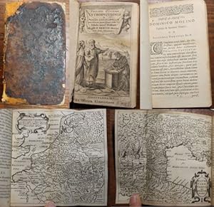
One of the later editions of the "Introduction to Universal Geography", the first comprehensive modern geography, originally published in 1624-1629; it remained a standard work through the mid-18th century; the first of its six parts deals in general with the Earth, the remaining five contain short descriptions of countries and stress human and historical considerations. Written by Philipp Clüver (1580-1622), a Leiden-based German geographer, the founder of historical geography. This edition is supplemented with "Breviarium Totius Orbis Terrarum" and a survey of Roman emperors (short works by Petrus Bertius), followed by an index. The book features an engraved title page with putti and three figures of geographers. The copy contains a set of 4 fold-out plates (tables, diagrams) and 37 fold-out maps (copper engravings), both historical and modern, e.g. hemispheres, Europe, historical Roman provinces, Britain and Ireland, various European countries, various parts of Italy, Russia, Asia, China, India, Persia, Africa, America, various parts of the Middle East etc. Only a map of Galia is missing (torn away). Antiqua typeface; pages are decorated with headpieces and initials. The front endpaper and title leaf contain several ownership notes. /// Parchment binding (with handwritten title); hardback, [12]+388+[6]+[70] pp., 4 plates + 37 maps, 12° (7.5 x 13.5 cm), parchment discoloured and slightly worn, top edge darkened, fore edge with small ink stain, back hinge split, front free endpaper partly glued to front board, first plate with loss along bottom edge (diagram and text slightly corrupted), most pages, plates and maps with small narrow water stain along top edge, several maps with tear on folds, one map backed with small pieces of paper, one leaf's corner torn away (text slightly corrupted), last leaf partly detached, several leaves slightly worn along edges, other signs of wear and age are rare (minor creases and tears, small ink stain), one map missing, condition: good Book Language/s: Latin.
-

Philippi Cluverii Introductionis in Universam Geographiam tam Veterem quam Novam, Libri VI. Editio ultima, prioribus Emendator.
Verlag: Michaelem Soly,, 1630
12 °, 506 S., 7 Bl., 17 Bl., gestochenes illustrierter Titelblatt, 1 mehrfach gefaltete Tafel mit Abbildungen, Kapitelvigetten, Illustrierte Kapitelinitiale, Zustand 3, Pergament an hinterer Rückenkante angeplatzt (2 cm), Schließbänder abgerissen, Vorsatz von Spiegeln abgelöst, vom weißen oberen Titelrand 8 mm abgeschnitten, Titelkupfer etwas berieben, Pergamentband der Zeit mit aufkaschiertem handschriftlichem zweifarbigem Rückentitel in Tinte.
-

Philippi Cluverii Introductionis in universam geographiam, tam veterem quam novam Libri 6. Tabulis aeneis illustrati. Accessit P. Bertii breviarum Orbis Terrarum
Verlag: ex officina Elzeviriana, Amstelodami, 1661
Anbieter: Libreria Antiquaria Giulio Cesare di Daniele Corradi, Roma, RM, Italien
Verkäuferbewertung 2 von 5 Sternen

Piccole naturali imperfezioni e mancanze al frontespizio. Piacevoli e interessanti annotazioni coeve ai margini di alcune pagine o ai risguardi delle tavole. La decima tavola (inferioris Germaniae) e stata montata capovolta. Qualche leggera gora su alcune carte (12) + 388 + (72) con 41 tavole geografiche incise a doppia pagina p. 140x85 mm p.perg. ottocentesca con bindelle.
-

Philippi Cluverii Introductionis in Universam Geographiam tam Veterem quam Novam, Libri VI. Editio ultima, prioribus Emendator.
Verlag: Amsterdam, Hondium,, 1677
Sprache: Latein
Anbieter: Antiquariat Berghammer, Gräfelfing, Deutschland
Verbandsmitglied: GIAQ
Verkäuferbewertung 5 von 5 Sternen
352, 70 S. mit einem Titelkupfer + 2 gefalteten Kupfertafeln la Gewicht in Gramm: 400 kl-8°, Pergamenteinband der Zeit, Pergament an den Rändern beschädigt, sonst guter und Innen sauberer Zust.
-
Umfangreiches Fragment : Philippi Cluverii introductionis in universam geographiam tam veterem quam novam libri VI. : tabulis aeneis illustrati. Accessit P. Bertii breviarium orbis terrarum.
Verlag: Amsterdam, Elzevir, 1659
Sprache: Latein
Anbieter: Antiquariat im OPUS, Silvia Morch-Israel, Oppenheim, Deutschland
Verkäuferbewertung 5 von 5 Sternen
Ledereinband, ca. 13 x 8 cm. Zustand: Befriedigend. 4 nn.Bl., 390 S. (von 394), 12 nn.Bl. 36 Kupferstich-Landkarten (von 38 Landkarten), Kupferstichtitel, eine Tabelle Es fehlen 4 Textseiten, es fehlen 2 Landkarten (Globi mundi und Hispania) und 2 gefaltete Tafeln. Einband berieben, bestossen und beschabt, Vorderdeckel mit Klebeband fixiert, Innengelenk offen. Vermerke auf Innendeckel, kleiner Wurmgang S.275-294 (Buchstabenverlust), einzelne Knickspuren, einzelne Blatt mit Randbeschädigungen , eine Karte alt hinterlegt (Palästina), die restlichen Karten gut und sauber erhalten. Beleg,-Arbeitsexemplar. la Gewicht in Gramm: 244.