Gesamtpreis (1 Artikel Artikel):
Versandziel:

young james hamilton (19 Ergebnisse)
Direkt zu den wichtigsten Suchergebnissen
Suchfilter
Produktart
- Alle Product Types
- Bücher (16)
- Magazine & Zeitschriften (Keine weiteren Ergebnisse entsprechen dieser Verfeinerung)
- Comics (Keine weiteren Ergebnisse entsprechen dieser Verfeinerung)
- Noten (Keine weiteren Ergebnisse entsprechen dieser Verfeinerung)
- Kunst, Grafik & Poster (1)
- Fotografien (Keine weiteren Ergebnisse entsprechen dieser Verfeinerung)
- Karten (2)
- Manuskripte & Papierantiquitäten (Keine weiteren Ergebnisse entsprechen dieser Verfeinerung)
Zustand Mehr dazu
Einband
Weitere Eigenschaften
- Erstausgabe (2)
- Signiert (2)
- Schutzumschlag (Keine weiteren Ergebnisse entsprechen dieser Verfeinerung)
- Angebotsfoto (8)
Sprache (2)
Gratisversand
Land des Verkäufers
Verkäuferbewertung
-

On Global Wizardry: Techniques of Pagan Spirituality and a Christian Response
Anbieter: ThriftBooks-Dallas, Dallas, TX, USA
Verkäuferbewertung 5 von 5 Sternen

Paperback. Zustand: Fair. No Jacket. Sarah Sisco (illustrator). Readable copy. Pages may have considerable notes/highlighting. ~ ThriftBooks: Read More, Spend Less.
-

Christianity Designed and Adapted to Be a Universal Religion: A Discourse Delivered at the Ordination of the Rev. James W. Thompson, As Pastor of the ... Society, in Natick, Feb. 17, 1830.
Anbieter: Ria Christie Collections, Uxbridge, Vereinigtes Königreich
Verkäuferbewertung 5 von 5 Sternen
EUR 17,73
EUR 13,86 Versand
Versand von Vereinigtes Königreich nach USAAnzahl: Mehr als 20 verfügbar
In den WarenkorbZustand: New. In.
-

A System of Physical Geography. to Which Is Added a Treatise on the Physical Geography of the United States. the Whole Embellished by Numerous Engravings and Maps. by J. H. Young.
Sprache: Englisch
Verlag: British Library, Historical Print Editions, 2011
ISBN 10: 1241504458 ISBN 13: 9781241504458
Anbieter: Ria Christie Collections, Uxbridge, Vereinigtes Königreich
Verkäuferbewertung 5 von 5 Sternen
EUR 19,89
EUR 13,86 Versand
Versand von Vereinigtes Königreich nach USAAnzahl: Mehr als 20 verfügbar
In den WarenkorbZustand: New. In.
-

Christianity Designed and Adapted to Be a Universal Religion: A Discourse Delivered at the Ordination of the Rev. James W. Thompson, As Pastor of the ... Society, in Natick, Feb. 17, 1830.
Anbieter: Ria Christie Collections, Uxbridge, Vereinigtes Königreich
Verkäuferbewertung 5 von 5 Sternen
EUR 31,22
EUR 13,86 Versand
Versand von Vereinigtes Königreich nach USAAnzahl: Mehr als 20 verfügbar
In den WarenkorbZustand: New. In.
-
![Bild des Verkäufers für The Big Band Era Piano, Vocal and Guitar Chords [2th Street Rag -- A Cottage For Sale -- A Foggy Day -- A Ghost Of A Chance -- A String Of Pearls -- All Of Me -- Amapola -- Bye Bye Blues -- Careless -- Charmaine -- Cherokee -- Darn That Dream -- East Of The Sun -- Everything Happens To Me -- Got A Date With An Angel -- Harbor Lights -- Here's that Rainy Day -- Honeysuckle Rose. How High the Moon -- I Can Dream, Can't I? -- I Can't Get Started -- I Didn't Know What Time It Was -- I Don't Want to Set The World On Fire -- I'll Be Around -- I'll Get By -- I'll Remember April -- I'm A Dreamer Aren't We All -- I'm Beginning To See The Light -- I'm Confessin' -- I'm Gonna Sit Right Down and Write Myself A Letter -- Imagination. In A Shanty In Old] zum Verkauf von Joseph Valles - Books](https://pictures.abebooks.com/inventory/md/md32405256755.jpg)
The Big Band Era Piano, Vocal and Guitar Chords [2th Street Rag -- A Cottage For Sale -- A Foggy Day -- A Ghost Of A Chance -- A String Of Pearls -- All Of Me -- Amapola -- Bye Bye Blues -- Careless -- Charmaine -- Cherokee -- Darn That Dream -- East Of The Sun -- Everything Happens To Me -- Got A Date With An Angel -- Harbor Lights -- Here's that Rainy Day -- Honeysuckle Rose. How High the Moon -- I Can Dream, Can't I? -- I Can't Get Started -- I Didn't Know What Time It Was -- I Don't Want to Set The World On Fire -- I'll Be Around -- I'll Get By -- I'll Remember April -- I'm A Dreamer Aren't We All -- I'm Beginning To See The Light -- I'm Confessin' -- I'm Gonna Sit Right Down and Write Myself A Letter -- Imagination. In A Shanty In Old]
Sprache: Englisch
Verlag: Hal Leonard Pub., Winona, MN, 1984, 1984
ISBN 10: 1423424034 ISBN 13: 9781423424031
Anbieter: Joseph Valles - Books, Stockbridge, GA, USA
Verkäuferbewertung 5 von 5 Sternen
Soft cover. Zustand: Fine. 2nd Edition. 1 vocal score (247 pages) ; 31 cm OCLC 12770247 ; pictorial stiff paper wrappers ; Publisher's number: HL00359260; For voice and piano with guitar chord diagrams ; Contents: 12th Street Rag -- A Cottage For Sale -- A Foggy Day -- A Ghost Of A Chance -- A String Of Pearls -- All Of Me -- Amapola -- Bye Bye Blues -- Careless -- Charmaine -- Cherokee -- Darn That Dream -- East Of The Sun -- Everything Happens To Me -- Got A Date With An Angel -- Harbor Lights -- Here's that Rainy Day -- Honeysuckle Rose. How High the Moon -- I Can Dream, Can't I? -- I Can't Get Started -- I Didn't Know What Time It Was -- I Don't Want to Set The World On Fire -- I'll Be Around -- I'll Get By -- I'll Remember April -- I'm A Dreamer Aren't We All -- I'm Beginning To See The Light -- I'm Confessin' -- I'm Gonna Sit Right Down and Write Myself A Letter -- Imagination. In A Shanty In Old Shanty Town -- In The Mood -- Indiana -- It's Only A Paper Moon -- Jersy Bounce -- Juke Box Saturday Night -- Let's Call the Whole Thing Off -- Lili Marlene -- Love Is Here To Stay -- Lullaby Of The Leaves -- Manhattan -- Moonglow -- Moonlight and Roses -- Moonlight In Vermont -- More Than You Know -- My Heart Belongs To Daddy. -- My Prayer -- Nevertheless -- Nice Work If You Can Get It -- Oh, Johnny Oh -- Old Devil Moon -- Opus One -- Paper Doll -- Pennies From Heaven -- Poinciana -- Polka Dots And Moonbeams -- Put Your Dreams Away -- Red Sails In The Sunset -- Sleepy Lagoon -- Somebody Else Is Taking My Place -- Stompin' At The Savoy -- Sunday, Monday or Always. Sweet Sue Just You -- T'ain't What You Do -- The Breeze and I -- The Music Goes 'Round And Around -- The Object Of My Affection -- The Story Of A Starry Night -- The Varsity Drag -- There Are such Things -- There'll Be Some Changes Made -- There's A Small Hotel -- These Foolish Things -- They All Laughed -- They Can't Take That Away From Me. Things We Did Last Summer -- Three Little Fishies -- Till The End Of Time -- Together -- Tuxedo Junction -- Under A Blanket Of Blue -- What A Diff'rence A Day Made -- Where The Blue Of The Night (Meets The Gold Of The Day) -- Willow Weep For Me -- Yes, Indeed -- You Better Go Now -- You Turned The Tables On Me -- You'd Be So Nice To Come Home To -- You're My Everything. You're The Cream In My Coffee -- Yours ; a few marks, else FINE. Book.
-

A system of Physical Geography. To which is added a treatise on the Physical Geography of the United States. The whole embellished by numerous engravings and maps. By J. H. Young.
Sprache: Englisch
Verlag: British Library, Historical Print Editions, 2011
ISBN 10: 1241504458 ISBN 13: 9781241504458
EUR 26,70
EUR 48,99 Versand
Versand von Deutschland nach USAAnzahl: Mehr als 20 verfügbar
In den WarenkorbZustand: New.
-

Young, A: CHRISTIANITY DESIGNED & ADAPTE
Anbieter: AHA-BUCH GmbH, Einbeck, Deutschland
Verkäuferbewertung 5 von 5 Sternen
Taschenbuch. Zustand: Neu. Neuware - This is an EXACT reproduction of a book published before 1923. This IS NOT an OCR'd book with strange characters, introduced typographical errors, and jumbled words. This book may have occasional imperfections such as missing or blurred pages, poor pictures, errant marks, etc. that were either part of the original artifact, or were introduced by the scanning process. We believe this work is culturally important, and despite the imperfections, have elected to bring it back into print as part of our continuing commitment to the preservation of printed works worldwide. We appreciate your understanding of the imperfections in the preservation process, and hope you enjoy this valuable book.
-
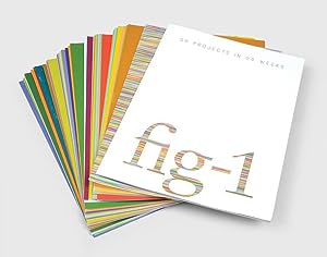
fig-1: 50 Projects in 50 Weeks.The deluxe portfolio, Signed by all the artists. First edition.
Sprache: Englisch
Verlag: London: Spafax Publishing; tate, the art magazine ; Philip Allison, 2001
ISBN 10: 1874235449 ISBN 13: 9781874235446
Anbieter: Wittenborn Art Books, San Francisco, CA, USA
Verkäuferbewertung 5 von 5 Sternen
Kunst / Grafik / Poster Signiert
Zustand: Good. 4to. 21x 29.7cm. Sheets loose as issued in original silver printed chemise and box. 28pp. text; poster and 50 signed broadsides, folded from 59.5 x 42cm. to 8 pages. Fine condition. .The deluxe portfolio, 2000-01, comprising 50 offset lithographs, on smooth wove paper, with title-page and text, each signed by the respective artist, the sheets folded (as issued), within the original silver Solander box with debossed cover and spine.Richard Hamilton, Gavin Turk, Tim Stoner, Philip Treacy, Caruso St John, John Hilliard, Liam Gillick, Georgie Hopton & Josephine Soughton, Jake & Dinos Chapman, Mark Hosking, Grayson Perry, Simon Patterson, Runa Islam, Anish Kapoor, Bella Freud, Tacita Dean, Antony Gormley, Carey Young, Marine Hugonnier, Will Self, Fiona Rae, Tracey Emin, Christopher Le Brun, Liam Gillick, Douglas Gordon, Carsten Holler, Pierre Huyghe, Philippe Parreno, Rirkrit Tiravanija, Nigel Shafran, Anya Gallaccio, James White & Tim Sheward, Mark Lewis, Richard Deacon & Martin Kreyssig, Wolfgang Tillmans, Joao Penalva, Matthew Higgs, Oliver Payne & Nick Relph, John Latham, Gilbert & George, Enrico David, Mona Hatoum, Andrew Lewis, Cerith Wyn Evans, Howard Hodgkin, Tom Gidley, Sam Taylor-Wood, Harland Miller, Peter Doig, Hussein Chalayan, Patti Smith, Darren Almond, Michael Craig-Martin, Jeremy Deller, Bridget Riley."fig-1" was a project initiated by Mark Francis and White Cube founder Jay Jopling, who held 50 one-week exhibitions at a disused venue in Soho, London.The project called together 49 British artists of different generations, from veterans such as Richard Hamilton, Howard Hodgkin, Anish Kapoor, and Bridget Riley, to established YBAs including Jake & Dinos Chapman, Tracey Emin, and Gavin Turk, and up and coming, soon to be illustrious names, such as Peter Doig, Grayson Perry and Harland Miller - each one of them exhibiting for one week, with Richard Hamilton showing twice in the first and last week.Divided into 50 sections, the book chronicles each project in the words of the participants through interviews, essays and visual documentaries. .Arrangment of the prints: 01. Richard Hamilton02. Gavin Turk03. Tim Stoner04. Philip Treacy05. Caruso St. John06. John Hilliard07. Liam Gillick08. Georgie Hopton + Josephine Soughan09. Jake + Dinos Chapman10. Mark Hisking11. Grayson Perry12. Simon Patterson13. Runa Islam14. Anish Kapoor15. Bella Freud16. Tacita Dean17. Antony Gormley18. Carey Young19. Marine Hugonnier20. Will Self21. Fiona Rae22. Tracey Emin23. Christopher Le Brun24. Liam Gillick, Douglas Gordon, Carsten Höller, Pierre Huyghe, Philippe Parreno, Rirkrit Tiravanija25. Nigel Shafran26. Anya Gallaccio27. James White + Tim Sheward28. Mark Lewis29. Richard Deacon + Martin Kreyssig30. Wolfgang Tillmans31. Joăo Penalva32. Matthew Higgs, Oliver Payne + Nick Relph33. John Latham34. Gilbert + George35. Enrico David36. Mona Hatoum37. Andrew Lewis38. Cerith Wyn Evans39. Howard Hodgkin40. Tom Gidley41. Sam Taylor-Wood42. Harland Miller43. Peter Doig44. Hussein Chalayan45. Patti Smith46. Darren Almond47. Michael Craig-Martin48. Jeremy Deller49. Bridget Riley50. Richard Hamilton.
-
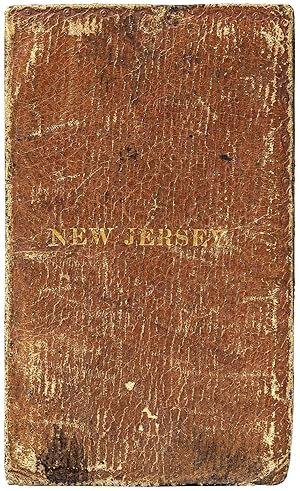
New Jersey: Finley's New and Correct Pocket Maps, for Travelers (1826)
Verlag: A. Finley, No. 35 South Fourth Street, Philadelphia, 1826
Anbieter: Between the Covers-Rare Books, Inc. ABAA, Gloucester City, NJ, USA
Verbandsmitglied: ABAA ESA ILAB IOBA
Verkäuferbewertung 5 von 5 Sternen
Hardcover. Zustand: Very Good. 24mo. (2" x 3 Ľ"). Folding pocket map of New Jersey engraved by Young & Dellecker (9" x 11 Ľ"), with all counties hand colored in full period colors. Mounted on the inside back cover of a contemporary russet calf binding, with "New Jersey" stamped in gold on front cover, and Finley's full title and blurb printed in letterpress on the inside front pastedown. Boards rubbed and lightly stained, slight color bleeding, very good. One of the earliest pocket maps of Anthony Finley, considered among the greatest of American map makers of the Federal period. His map of New Jersey is especially rare. A well-preserved copy with bright hand coloring. No copies in *OCLC*.
-

A New Map of Texas with the Contigous American and Mexican States.
Verlag: Philadelphia: S. Augustus Mitchell, 1837., 1837
Anbieter: Arader Galleries - AraderNYC, New York, NY, USA
Verkäuferbewertung 5 von 5 Sternen
Hardcover. Single sheet (12 2/8 x 15 inches to the neat line, full margins). Engraved folding map on bank note paper, with fine original hand-colouring in full (washed and laid-down on archival tissue, with facsimile repairs to the insets of text and affecting the image in a number of places). Original black roan, gilt, front cover of pocket folder present (detached). Third issue of one of the earliest printed maps of Texas from the Republic era. The map shows Texas divided into the land grants parceled out by the Mexican state of Coahuila y Tejas. It is smaller than the area claimed by the Republic after independence, with the Nueces River as the southern boundary. All territory north of the Red River is attached to "Santa Fe formerly New Mexico". The three text inserts are titled "Remarks on Texas," "Land Grants," and "Rivers of Texas," and are clearly designed to encourage emigration to the region: "Texas is one of the finest stock countries in the world. Cattle are raised in great abundance, and with but little trouble. Many of the settlers count their herds by hundreds, and great numbers are annually purchased, and driven to New Orleans by drovers, who visit the country for that purpose. The population is estimated at near 45,000 Americans and 4 or 5,000 Mexicans. When the population shall be found to number 50,000, the people will endeavor to obtain a government separate from that of Cohahuila [sic], the establishment of a State legislature at San Felipe, and the right of electing their own representatives to the General Congress at Mexico". Raines, page 250; Streeter 1178B "The same plate is used for all editions of this map".
-
Mitchell's Traveller's Guide through the United States, Containing the Principal Cities, Towns, &c Alphabetically Arranged; Together with the Stage, Steam-Boat, Canal, and Rail-Road Routes, with the Distances, in Miles, from Place to Place.
Verlag: Philadelphia: Thomas, Cowperthwait & Co., [1845]., 1845
Anbieter: Arader Galleries - AraderNYC, New York, NY, USA
Verkäuferbewertung 5 von 5 Sternen
Hardcover. Folding engraved map (17 4/8 x 21 4/8 inches) showing the United States as far west as Indiana Territory, as far south as Florida with 8 insets of the Vicinity of Cincinnati; Vicinity of Albany; Vicinity of the Falls of Niagara; Vicinity of New York; Vicinity of Charleston; Vicinity of Baltimore and Washington; Vicinity of Philadelphia; and Vicinity of Boston, with original hand-colour in outline (very browned). 78-page guide. Original blind-embossed tan roan, lettered in gilt on upper cover. Provenance: Several canal routes through Ohio, Indiana, Pennsylvania, and New York shown in blue ink. First published in 1832, with accompanying text added in 1834, and continuously updated and enlarged. "Internal improvements coupled with the great Irish and German migrations beginning in 1827 led to the production of traveler's guides that depicted roads and their distances, steamboat and canal routes, and lengths of principal railroads. In 1832 Samuel Augustus Mitchell first issued his 'Traveller's Guide through the United States' and complimented it two years later with 'Tourist Pocket Maps' of the different states. These early works and their multitudinous progeny over the next fifty years laid the foundation for the road maps of today" (Schwartz & Ehrenberg, The Mapping of America, page 255).
-
Map of the States of Ohio, Indiana and Illinois with the Settled Part of Michigan.
Verlag: Philadelphia: S. Augustus Mitchell, 1835., 1835
Anbieter: Arader Galleries - AraderNYC, New York, NY, USA
Verkäuferbewertung 5 von 5 Sternen
Hardcover. Engraved folding pocket map (17 4/8 x 21 6/8 inches to the neat-line, full margins). Letterpress census laid down on the front past-down. Fine folding engraved map with insets of the "Lead Region East of the Mississippi River"; "Falls of Ohio"; "Vicinity of Cincinnati"; and "Vicinity of Detroit", with original hand-colour in full (some browing and short separations at folds). Contemporary publisher's red roan, gilt (scuffed). First issued in 1834, and with some changes from that issue: Lake Michigan has been redrawn, the addition of new counties in Indiana is notes, such as Porter, Newton, and Jasper, etc.). Iowa did not become a territory until 1838 and a state until 1844, and is labeled here as Missouri and Wisconsin Territory. Interestingly this map shows the controversial Dubuque lead mining region, including the site of Julien Dubuque's grave. Between 1796, when this grant was confirmed by the Spanish governor of Louisiana, and his death in 1810, Dubuque had succeeded in establishing a monopoly controlling the smelting and shipping of lead from the region, known as the "Mines of Spain". Unable to sustain a working relationship with the local Ioway Indians Dubuque's creditors who succeeded to his rights abandoned the enterprise, and lead-mining rights in Iowa remained in a legal turmoil that lasted until 1853, when the United States Supreme Court issued a landmark decision on the ownership of the Dubuque area mines, disallowing claims based on Julien Dubuque's Spanish land grants.
-
Map of the States of Ohio, Indiana and Illinois with the Settled Part of Michigan.
Verlag: Philadelphia: S. Augustus Mitchell, 1836., 1836
Anbieter: Arader Galleries - AraderNYC, New York, NY, USA
Verkäuferbewertung 5 von 5 Sternen
Hardcover. Engraved folding pocket map (17 4/8 x 22 2/8 inches to the neat-line, full margins). Letterpress census laid down on the front past-down. Fine folding engraved map with insets of the "Lead Region East of the Mississippi River"; "Falls of Ohio"; "Vicinity of Cincinnati"; and "Vicinity of Detroit", with original hand-colour in full (some spotting and offseting). Contemporary publisher's cherry roan, gilt (a bit rubbed). First issued in 1834, and with some changes from that issue: Lake Michigan has been redrawn, the addition of new counties in Indiana is notes, such as Porter, Newton, and Jasper, etc.). Iowa did not become a territory until 1838 and a state until 1844, and is labeled here as Missouri and Wisconsin Territory. Interestingly this map shows the controversial Dubuque lead mining region, including the site of Julien Dubuque's grave. Between 1796, when this grant was confirmed by the Spanish governor of Louisiana, and his death in 1810, Dubuque had succeeded in establishing a monopoly controlling the smelting and shipping of lead from the region, known as the "Mines of Spain". Unable to sustain a working relationship with the local Ioway Indians Dubuque's creditors who succeeded to his rights abandoned the enterprise, and lead-mining rights in Iowa remained in a legal turmoil that lasted until 1853, when the United States Supreme Court issued a landmark decision on the ownership of the Dubuque area mines, disallowing claims based on Julien Dubuque's Spanish land grants.
-
Map of the States of Ohio, Indiana and Illinois with the Settled Part of Michigan.
Verlag: Philadelphia: S. Augustus Mitchell, 1837., 1837
Anbieter: Arader Galleries - AraderNYC, New York, NY, USA
Verkäuferbewertung 5 von 5 Sternen
Hardcover. Single sheet (17 x 21 inches to the neat-line, full margins). Letterpress census laid down on the front past-down. Fine folding engraved map with insets of the "Lead Region East of the Mississippi River"; "Falls of Ohio"; "Vicinity of Cincinnati"; and "Vicinity of Detroit", with original hand-colour in full (laid down on archival tissue, one or two small losses, some staining). Original black roan, gilt (a bit rubbed). Provenance: some canal routes marked in red and blue pen. First issued in 1834, and with some changes from that issue: Lake Michigan has been redrawn, the addition of new counties in Indiana is notes, such as Porter, Newton, and Jasper, etc.). Iowa did not become a territory until 1838 and a state until 1844, and is labeled here as Missouri and Wisconsin Territory. Interestingly this map shows the controversial Dubuque lead mining region, including the site of Julien Dubuque's grave. Between 1796, when this grant was confirmed by the Spanish governor of Louisiana, and his death in 1810, Dubuque had succeeded in establishing a monopoly controlling the smelting and shipping of lead from the region, known as the "Mines of Spain". Unable to sustain a working relationship with the local Ioway Indians Dubuque's creditors who succeeded to his rights abandoned the enterprise, and lead-mining rights in Iowa remained in a legal turmoil that lasted until 1853, when the United States Supreme Court issued a landmark decision on the ownership of the Dubuque area mines, disallowing claims based on Julien Dubuque's Spanish land grants.
-
The Tourists Pocket map of Pennsylvania Exhibiting Its Internal Improvements, Road Distances, &c.
Verlag: Philadelphia: S. Augustus Mitchell, 1833., 1833
Anbieter: Arader Galleries - AraderNYC, New York, NY, USA
Verkäuferbewertung 5 von 5 Sternen
Hardcover. Single sheet (13 x 14 6/8 inches to the neat-line, full margins). Letterpress Pennsylvania Census for 1830 laid-down on the front paste-down, Mitchell's imprint on the back paste-down. Fine engraved map of Pennsylvania, with insets of the Lehigh and Schuylkill Coal Regions, the Vicinity of Philadelphia, and a profile of Pennsylvania Canal, with original hand-colour in full (one or two separations at folds). Original blue roan, gilt (expertly rebacked to style). First published by Mitchell, one of America's pre-eminent cartographers, in 1831 in his re-issue of Finley's "New American Atlas" but with considerable additions and improvements, on which he collaborated with Young. Mitchell and Young continued to work together for decades, including on this series of pocket maps, of which this is one of the earliest.
-
The Tourist's Pocket Map of Pennsylvania Exhibiting its Internal Improvements, Roads Distances &c [cover title: Mitchell's Map of Pennsylvania]
Verlag: S. Augustus Mitchell, Philadelphia, 1839
Anbieter: Capitol Hill Books, ABAA, Washington, DC, USA
Verkäuferbewertung 5 von 5 Sternen
Zustand: Very Good. Philadelphia: S. Augustus Mitchell , 1839. Later issue with 1831 copyright and 1839 under publisher information. 12mo. Full hand-colored fold-out map (38x32.5cm) housed in original embossed red leather binding with gilt stamping to front. Light wear to extremities and binding is sound. Later gift inscriptions to pastedown. Mild toning to edges of map with a few brief splits to folds, else sound and colors remain bright. Includes actual and proposed canals and railroads as well as a profile of the Pennsylvania Canal. A lovely example of the collaboration between Mitchell, the manager and geographer, and Young, the artist and engraver. The pair would continue to work closely together for many years.
-
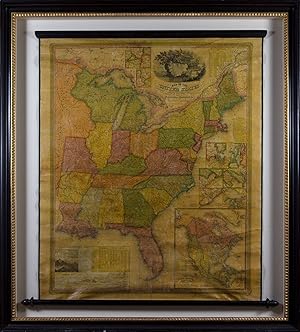
Map of the United States by J. H. Young
Verlag: S. Augustus Mitchell, Philadelphia, 1831
Karte Erstausgabe
No binding. Zustand: Very good. First. First edition. [Philadelphia]: S. Augustus Mitchell, 1831. First Edition. 37 3/4" x 44 1/2". Framed in UVIII Plexiglass. Dampstain to the upper margin. Cockled generally, with some creases and splits. Varnish yellowed quite evenly, with some patches of abrasion. Not examined out of frame. Engraved wall map by Young, D. Haines, & F. Dankworth on original wooden rollers, edged with green silk, with original hand-coloring. Large engraved-title vignette of an eagle perched on a rock carved with the federal shield with marine and coastal views in the background, large inset "Map of North America including All the Recent Geographical Discoveries," smaller inset maps of the vicinities of Albany, the Falls of Niagara, Boston, New York, Philadelphia, Baltimore and Washington, Charleston, and New Orleans, several inset tables and charts including comparative heights of mountains and comparative lengths of rivers. A very good copy of the first edition of the first wall map issued by Mitchell, and his first fully original cartographical publication. Rumsey points out that Ristow is mistaken in claiming that counties are delineated and numbered in all versions of this map: the present edition, "the first, does not, thereby eliminating the index of counties and thus showing more of the western territory." Karrow 1:1473; Ristow, p. 309; Rumsey 2723.
-
Fig-1 50 Projects in 50 Weeks.
Verlag: London: Spafax Publishing in association with tate: the art magazine, 2001, 2001
Anbieter: Peter Harrington. ABA/ ILAB., London, Vereinigtes Königreich
Verbandsmitglied: ABA ILAB PBFA
Verkäuferbewertung 5 von 5 Sternen
Erstausgabe Signiert
EUR 17.868,97
EUR 25,44 Versand
Versand von Vereinigtes Königreich nach USAAnzahl: 1 verfügbar
In den WarenkorbFirst edition, first printing. Edition of 50 signed by the artists. Fig-1 was 50 projects in 50 weeks initiated by Mark Francis and Jay Jopling, set in a small warehouse building in Soho, each project lasting one week. Each poster is signed by the relevant artist or artists. The projects embraced a broad range of contemporary creative productions including fine art, with 13 Turner Prize nominees, as well as literature, film and video, fashion, design, and architecture. Quarto, 32 page stapled booklet, A1 folded poster with photo-portraits of all the artists, 50 A2 folded posters. With the original silver card clamshell box. Box lightly rubbed to edges, else fine.
-
A NEW MAP OF TEXAS, WITH THE CONTIGUOUS AMERICAN & MEXICAN STATES.
Verlag: PHILADELPHIA: PUBLISHED BY S. AUGUSTUS MITCHELL, SOLD BY MITCHELL & HINMAN, 1835., 1835
Anbieter: Arader Galleries - AraderNYC, New York, NY, USA
Verkäuferbewertung 5 von 5 Sternen
Karte
Zustand: Very Good. 1st Issue. Engraved pocket map (12 x 14 3/4 in.; 302 x 367 mm), full contemporary handcoloring, engraved by Young, engraved text panels providing "Remarks on Texas" and information concerning "Rivers of Texas," and Land Grants." Handsomely framed and glazed with UVIII Plexiglass. Trimmed to neatline. FIRST ISSUE OF THIS CELEBRATED MITCHELL-YOUNG MAP, ISSUED ON THE EVE OF THE TEXAS REVOLUTION and particularly important for the texts in three corners. Conditions for issuing land grants are explained, with the guarantee: "New settlers are exempt from the payment of the usual taxes for the term of 10 years." Both the other texts discuss the probability of navigating by steam along Texas waterways, with "Rivers of Texas" boasting that the Brazos River is "considered equal in fertility to any in the world." Prospective settlers were further encouraged by the "Remarks on Texas," which describe the "advantages which doubtless will at no distant period render it an opulent and powerful State." Hugely influential, eight editions of this map were published between 1835 and 1845. Map.


![Bild des Verkäufers für The Tourist's Pocket Map of Pennsylvania Exhibiting its Internal Improvements, Roads Distances &c [cover title: Mitchell's Map of Pennsylvania] zum Verkauf von Capitol Hill Books, ABAA](https://pictures.abebooks.com/inventory/md/md32151920709.jpg)