
Gesamtpreis (1 Artikel Artikel):
Versandziel:

wyld william (6 Ergebnisse)
Direkt zu den wichtigsten Suchergebnissen
Suchfilter
Produktart
- Alle Product Types
- Bücher (2)
- Magazine & Zeitschriften (Keine weiteren Ergebnisse entsprechen dieser Verfeinerung)
- Comics (Keine weiteren Ergebnisse entsprechen dieser Verfeinerung)
- Noten (Keine weiteren Ergebnisse entsprechen dieser Verfeinerung)
- Kunst, Grafik & Poster (1)
- Fotografien (Keine weiteren Ergebnisse entsprechen dieser Verfeinerung)
- Karten (3)
- Manuskripte & Papierantiquitäten (Keine weiteren Ergebnisse entsprechen dieser Verfeinerung)
Zustand Mehr dazu
- Neu (Keine weiteren Ergebnisse entsprechen dieser Verfeinerung)
- Wie Neu, Sehr Gut oder Gut Bis Sehr Gut (Keine weiteren Ergebnisse entsprechen dieser Verfeinerung)
- Gut oder Befriedigend (2)
- Ausreichend oder Schlecht (Keine weiteren Ergebnisse entsprechen dieser Verfeinerung)
- Wie beschrieben (4)
Einband
Weitere Eigenschaften
- Erstausgabe (2)
- Signiert (1)
- Schutzumschlag (Keine weiteren Ergebnisse entsprechen dieser Verfeinerung)
- Angebotsfoto (6)
Sprache (1)
Preis
- Beliebiger Preis
- Weniger als EUR 20 (Keine weiteren Ergebnisse entsprechen dieser Verfeinerung)
- EUR 20 bis EUR 45 (Keine weiteren Ergebnisse entsprechen dieser Verfeinerung)
- Mehr als EUR 45
Gratisversand
- Kostenloser Versand nach USA (Keine weiteren Ergebnisse entsprechen dieser Verfeinerung)
Land des Verkäufers
Verkäuferbewertung
-

Ordnance Survey Map 8: Surrey, 1816.
Verlag: James Wyld, London 1876, 1876
Anbieter: ROBIN SUMMERS BOOKS LTD, Aldeburgh, Vereinigtes Königreich
Verkäuferbewertung 5 von 5 Sternen

Karte
EUR 119,03
EUR 33,51 Versand
Versand von Vereinigtes Königreich nach USAAnzahl: 1 verfügbar
In den WarenkorbZustand: Very Good. Paperback. Large folding, linen-backed map, 40 x 25 inches, scale 1 inch to 1 mile. One small mark, otherwise clean, very good indeed. Original cloth-backed case slightly worn and faded with label over original printed label. 1876 reproduction from the 1816 original.
-
Voyage pittoresque dans la Régence d'Alger exécuté en 1833, et lithographié par E. Lessore, & W. Wyld. Dédié ŕ Mr. Horace Vernet
Verlag: CHARLES MOTTE, 1835
Anbieter: Librairie Le Feu Follet, Paris, Frankreich
Verbandsmitglied: ILAB
Verkäuferbewertung 5 von 5 Sternen
Erstausgabe
Couverture rigide. Rare exemplaire de ce recueil "de trčs belles gravures, trčs précieuses pour la connaissance du vieil Alger" (Tailliart) | CHARLES MOTTE | Paris 1835 | 34 x 52.8 cm | Relié | Édition originale de cet important et précoce recueil de 50 superbes lithographies d'Alger sur chine montées sur papier fort exécutées par les deux peintres Emile-Aubert Lessore (1805-1876), pupille d'Ingres, et William Wyld (1806-1889), ami de Vernet, d'abord paru en cinq livraisons : bâtiments, paysages, types, scčnes, etc. Cf Bibliothčque algérienne de Gérard Sangnier, n°207. Pas dans Blackmer. Playfair, 517. Tailliart, 896. Gay, 919. Brunet III, 1018. Reliure en demi chevrette verte, dos lisse orné de triples filets dorés ainsi que de fleurons estampés ŕ froid, frises dorées en tęte et en queue du dos, la frise de tęte est partiellement effacée, plats de papier marbré comportant des traces de décolorations marginales, reliure de l'époque. Dos restauré, rousseurs éparses. * Les lithographies sont d'une finesse et d'une profondeur remarquable, rendant bien l'atmosphčre algéroise. "De trčs belles gravures, trčs précieuses pour la connaissance du vieil Alger" (Tailliart). | [ENGLISH DESCRIPTION FOLLOWS] First edition of this important and early collection of 50 superb lithographs of Algiers printed on china paper mounted on heavy wove, executed by the two painters Emile-Aubert Lessore (18051876), a pupil of Ingres, and William Wyld (18061889), a friend of Vernet. The work was originally issued in five parts: buildings, landscapes, figures, scenes, etc. See: Bibliothčque algérienne de Gérard Sangnier, no. 207. Not in Blackmer. Playfair, 517. Tailliart, 896. Gay, 919. Brunet III, 1018. Contemporary binding in half green shagreen, flat spine with triple gilt fillets and blind-stamped fleurons, gilt decorative bands at head and foot of spine, the upper band partially faded; marbled paper-covered boards with some marginal discoloration. Contemporary binding. Spine restored, occasional scattered foxing. * The lithographs display exceptional finesse and depth, vividly capturing the atmosphere of Algiers. "De trčs belles gravures, trčs précieuses pour la connaissance du vieil Alger" (Tailliart). in-folio ; titre, 20 pp. de légende des planches, et 50 planches lithographiées sur Chine montées sur papier fort.
-

A New Topographical Map of the Country in the Vicinity of London, describing all the New Improvements. Drawn from a Scale of two Inches to a Statute Mile.
Verlag: LondonPublished by James Wyld successor to Mr. Faden Geographer to His Majesty July 3 ., 1829
Anbieter: Robert Frew Ltd. ABA ILAB, London, Vereinigtes Königreich
Verbandsmitglied: ABA ILAB PBFA
Verkäuferbewertung 5 von 5 Sternen
Karte
EUR 892,72
EUR 11,56 Versand
Versand von Vereinigtes Königreich nach USAAnzahl: 1 verfügbar
In den WarenkorbOriginal hand-coloured engraved map of present day Greater London (88 x 84 cm) dissected into 45 sections and backed onto linen, attractively edged with green silk and folding between blue card covers into original cloth slipcase (worn) with engraved title-label. Extends from Edmonton in the north to Croydon in the South, Plumstead Marshes in the east and Barnes in the west. Slipcase cracked and with partial loss, map itself with just some light toning but generally in very good condition. A well-preserved example of an interesting map encompassing most of what is now considered to be Greater London. (Howgego, 250, 4a).
-
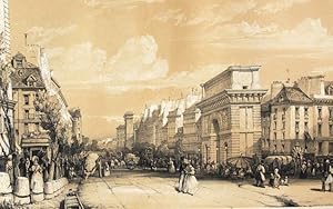
Monuments et Rues de Paris.
Verlag: Paris, Rittner & Goupil et Susse Frčres., 1839
Anbieter: Manfred Nosbuesch, Kuchenheim, Deutschland
Verkäuferbewertung 4 von 5 Sternen

Erstausgabe
EUR 2.380,00
EUR 15,00 Versand
Versand von Deutschland nach USAAnzahl: 1 verfügbar
In den WarenkorbGroß-Folio (57,5x38cm). Mit getöntem illustr. lithogr. Titel und 20 getönten lithogr. Tafeln jeweils mit Deckblatt. Dunkelgrüner Halblederband der Zeit mit geprägtem Rückentitel und -vergoldung. Erste Ausgabe. - Titelblatt fleckig. Die Tafeln stellenweise im Rand und rückseitig fleckig. - Gutes Exemplar.
-

An Arab Horseman.
Verlag: Paris: 1828, 1828
Anbieter: Wittenborn Art Books, San Francisco, CA, USA
Verkäuferbewertung 5 von 5 Sternen
Kunst / Grafik / Poster Signiert
Zustand: Good. Handcolored lithograph. 17 x 19.5 cm. sheet size. Signed with initiials"WW" and dated 1828. Mounted at the corners. See Beraldi, XII,m pp. 302-303 for similar images.
-
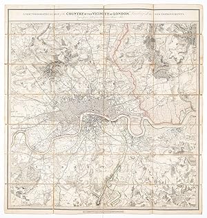
A New Topographical Map of the Country in the Vicinity of London, Describing all the New Improvements. Drawn from a Scale of two Inches to a Statute Mile.
Verlag: London July 3rd, 1828
Anbieter: Robert Frew Ltd. ABA ILAB, London, Vereinigtes Königreich
Verbandsmitglied: ABA ILAB PBFA
Verkäuferbewertung 5 von 5 Sternen
Karte
EUR 595,15
EUR 11,56 Versand
Versand von Vereinigtes Königreich nach USAAnzahl: 1 verfügbar
In den Warenkorb(87 x 82 cm). Original folding map of London with some original outline colour. The map, printed on paper, dissected and mounted on to linen, shows extents from Edmonton in the north to Beckenham in the south and from Barnes in the west to Plumstead in the east. Blue marbled paper to folded end sections. Label of 'G. Cruchley, Map Seller & Publisher, 38, Ludgate Street, St. Pauls, London' to lower margin and advertisement for 'Works Published and Sold by G. Cruchley' to folded end-section. Some toning and wear. Folds and corners reinforced on verso. James Wyld (1812-1887) was "the most important mapmaker producing maps of London in the year of the Great Exhibition". Wyld was a highly successful publisher, MP for Bodmin, and an active figure in public life. He promoted the development of the British Library and campaigned for the Public Libraries and Museums Bill. Like his father, he was made Geographer to Queen Victoria and Prince Albert in 1836. He built his business on his ability to produce maps quickly in reaction to new discoveries and information: Punch remarked drily that if a country were discovered in the centre of the earth then Wyld would have a new map out "as soon as it is discovered, if not before".
