
Gesamtpreis (1 Artikel Artikel):
Versandziel:

world map (260 Ergebnisse)
Direkt zu den wichtigsten Suchergebnissen
Suchfilter
Produktart
- Alle Product Types
- Bücher (93)
- Magazine & Zeitschriften (Keine weiteren Ergebnisse entsprechen dieser Verfeinerung)
- Comics (Keine weiteren Ergebnisse entsprechen dieser Verfeinerung)
- Noten (Keine weiteren Ergebnisse entsprechen dieser Verfeinerung)
- Kunst, Grafik & Poster (7)
- Fotografien (Keine weiteren Ergebnisse entsprechen dieser Verfeinerung)
- Karten (160)
- Manuskripte & Papierantiquitäten (Keine weiteren Ergebnisse entsprechen dieser Verfeinerung)
Zustand Mehr dazu
- Neu (2)
- Wie Neu, Sehr Gut oder Gut Bis Sehr Gut (2)
- Gut oder Befriedigend (48)
- Ausreichend oder Schlecht (Keine weiteren Ergebnisse entsprechen dieser Verfeinerung)
- Wie beschrieben (208)
Weitere Eigenschaften
Sprache (3)
Gratisversand
Land des Verkäufers
Verkäuferbewertung
-

Tectonic Map of North America. Scale 1:5,000,000 (softcovers explanation ONLY) (International Geological Congress Commission for the Geological Map of the World, XXII Session, India 1966).
Verlag: International Geological Congress., 1964
Anbieter: Eryops Books, Stephenville, TX, USA
Verkäuferbewertung 5 von 5 Sternen

Soft cover. Zustand: Very Good. Softcovers explanation only; softcovers; staple-bound; in very good condition. Book.
-

Bangkok Bus & Mass Transit Map / Thai - English / Details of 197 Bus Routes / BTS Map MRT Map and Bus Connection / Buses to Airport / Boat Route Map
Verlag: World Map Press, 2012
ISBN 10: 9745251542 ISBN 13: 9789745251540
Anbieter: WorldofBooks, Goring-By-Sea, WS, Vereinigtes Königreich
Verkäuferbewertung 5 von 5 Sternen
EUR 10,23
EUR 6,54 Versand
Versand von Vereinigtes Königreich nach USAAnzahl: 1 verfügbar
In den WarenkorbPaperback. Zustand: Very Good. The book has been read, but is in excellent condition. Pages are intact and not marred by notes or highlighting. The spine remains undamaged.
-

Bartholomew World Travel Map: China: scale : 1 : 4, 500, 000
Verlag: Edinburgh: John Bartholomew & Son Ltd., 1977
ISBN 10: 0851526403 ISBN 13: 9780851526409
Erstausgabe
First Edition. Near fine folding map. Remains well preserved overall; tight, bright, clean and sharp-cornered. Physical description; 1 folded map : text, col. map ; 25 cm. Subjects; China ; Maps. E0732900 E1344600 N0533300 N0175700. Scale 1:4,500,000. (E 73°29'00"--E 134°46'00"/N 53°33'00"--N 17°57'00"). Genre; Map. 3 Kg.
-
Tectonic Map of South America / Mapa Tectonico de America del Sur / Mapa Tectonico da America do Sul / Carte Tectonique de l'Amerique du Sud 1:5 000 000.
Verlag: Ministry of Mines and Energy, Brazil., 1978
Anbieter: Eryops Books, Stephenville, TX, USA
Verkäuferbewertung 5 von 5 Sternen
Soft cover. Zustand: Very Good. Softcovers explanation and two large folded maps in light cardboard slipcase; ex-corporate library; several small light spots on outside of slipcase; o/w book and maps are in very good condition. Book.
-
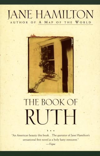
Paperback. Zustand: Collectible-Very Good. Ruth, a young woman living in a rural Illinois town, looks back on the people who have shaped her life, including her runaway father, shrewish mother, and crazy husband.
-
Bartholomew's World Layered Series Map of France And The Low Countries Northern Section In Layer Colouring With Roads And Distances Scale 1:1,000,000
Sprache: Englisch
Verlag: John Bartholomew & Son Ltd, Edinburgh
Anbieter: K Books Ltd ABA ILAB, York, YORKS, Vereinigtes Königreich
Verbandsmitglied: ABA ILAB PBFA
Verkäuferbewertung 5 von 5 Sternen
EUR 12,02
EUR 22,76 Versand
Versand von Vereinigtes Königreich nach USAAnzahl: 1 verfügbar
In den WarenkorbNo Binding. Zustand: Very Good. One folding linen backed colour map, with khaki card covers, scale of 1 : 1,000,000, some pen markings where places have been circled and small tears but o/w good condition, John Bartholomew & Son Ltd, Edinburgh, circa.
-
Tectonic Map of South America MC-32, explanatory note of map
Verlag: Departmento Nacional Da Producao Mineral, Brazil, 1978
Zustand: very good. explanatory note of map. cream envelope with brown stripes on sides, text 11.75" x 8.25", 89+ pages, no map.
-
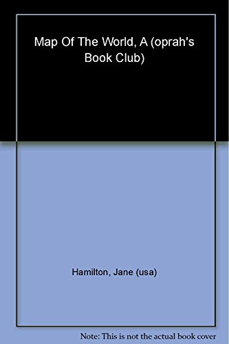
Paperback. Zustand: Collectible-Very Good. Pen /Hemingway Award-winning novelist Jane Hamilton follows up her first success, 'The Book Of Ruth,' with this spectacularly haunting drama about a rural American family and a disastrous event that forever changes their lives. 'Unforgettably, beat by beat, Hamilton maps the best and worst of the human heart and all the mysterious, uncharted country in between.' -- 'Kirkus Reviews.'.
-

Paperback. Zustand: New. From the author of the widely acclaimed The Book of Ruth comes a harrowing, heartbreaking drama about a rural American family and a disastrous event that forever changes their lives.The Goodwins, Howard, Alice, and their little girls, Emma and Claire, live on a dairy farm in Wisconsin. Although suspiciously regarded by their neighbors as 'that hippie couple' because of their well-educated, urban background, Howard and Alice believe they have found a source of emotional strength in the farm, he tending the barn while Alice works as a nurse in the local elementary school.But their peaceful life is shattered one day when a neighbor's two-year-old daughter drowns in the Goodwins' pond while under Alice's care. Tormented by the accident, Alice descends even further into darkness when she is accused of sexually abusing of a student at the elementary school. Soon, Alice is arrested, incarcerated, and as good as convicted in the eyes of a suspicious community. As a child, Alice designed her own map of the world to find her bearings. Now, as an adult, she must find her way again, through a maze of lies, doubt and ill will. A vivid human drama of guilt and betrayal, A Map of the World chronicles the intricate geographies of the human heart and all its mysterious, uncharted terrain.??The result is a piercing drama about family bonds and a disappearing rural American life.
-
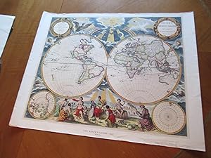
Map: Nieuwe Werelt Kaert Uyt Gegeven Tot Amsterdam By Pieter Goos (Facsimile)
Sprache: Englisch
Verlag: American Heritage, New York (Circa 1970?), 1970
Anbieter: Arroyo Seco Books, Pasadena, Member IOBA, Pasadena, CA, USA
Verbandsmitglied: IOBA
Verkäuferbewertung 4 von 5 Sternen

Karte
No Binding. Zustand: Near Fine. No Jacket. Double Globe World Map Printed From The Original (illustrator). Reprint Published By American Heritage. Size: Image About 20 3/4" X 17" On Heavy Glossy Paper.
-

Hardcover. Zustand: New. A standout in the crowd of first novels, Ruth narrates a story that confronts real-life issues of alienation and violence from which Hamilton creates a stunning testament to the human capacity for mercy, compassion, and love. Winner of the 1989 PEN/Hemingway Foundation Award.
-
WORLD IN HEMISPHERES - PHYSICAL - an Original Coloured Map, Printed C1908
Sprache: Englisch
Verlag: George Philip & Son/The London Geographical Institute, London, 1908
Anbieter: K Books Ltd ABA ILAB, York, YORKS, Vereinigtes Königreich
Verbandsmitglied: ABA ILAB PBFA
Verkäuferbewertung 5 von 5 Sternen
EUR 24,05
EUR 22,76 Versand
Versand von Vereinigtes Königreich nach USAAnzahl: 1 verfügbar
In den WarenkorbNo Binding. Zustand: Very Good. An original map, printed in full colour, central fold. Shows the Western and Eastern Hemispheres, the Water Hemisphere and the Land Hemisphere, and sections along various latitudes.
-
WESTEN HEMISPHERE MAP, ANTIQUE MAP - an Original Antique MAP
Sprache: Englisch
Erscheinungsdatum: 1866
Anbieter: K Books Ltd ABA ILAB, York, YORKS, Vereinigtes Königreich
Verbandsmitglied: ABA ILAB PBFA
Verkäuferbewertung 5 von 5 Sternen
EUR 14,43
EUR 22,76 Versand
Versand von Vereinigtes Königreich nach USAAnzahl: 1 verfügbar
In den WarenkorbNo Binding. Zustand: Very Good. An original antique coloured map printed in 1866. Mounted (matted) and ready to frame. Very good condition. AN EARLY MAP , IN GOOD CONDITION, MOUNT SIZE 12 X 14 INCHES, 34 X 38 CMS THE MAP SHOWS NORTH AND SOUTH AMERICA , PACIFIC ISLANDS AND NEW ZEALAND .
-
HYETOGRAPHIC OR RAIN MAP OF THE WORLD - an Original Antique Coloured Map, Published 1849
Sprache: Englisch
Verlag: William Blackwood & Sons, Edinburgh, 1849
Anbieter: K Books Ltd ABA ILAB, York, YORKS, Vereinigtes Königreich
Verbandsmitglied: ABA ILAB PBFA
Verkäuferbewertung 5 von 5 Sternen
EUR 30,06
EUR 22,76 Versand
Versand von Vereinigtes Königreich nach USAAnzahl: 1 verfügbar
In den WarenkorbNo Binding. Zustand: Very Good. Engraved By W & A K Johnston (illustrator). An original antique map, printed in 1849, but showing no date of publication. The map has been extended by Professor Berghaus, engraved by W & A K Johnston. Minimal contemporary colouring. Unmounted - will be posted rolled in a tube. Very good condition. The key at the bottom of the map offers details of the amount of rain the various zones, showing increase and decrease, and details of the significance of the shading of the map. There are also 2 pages of additional information.
-
Antique Hand Coloured Classical Map of the World (scandinavia to N. Africa, Britain to India) - Attractive Colouring and Detailed
Sprache: Englisch
Verlag: Philadelphia, 1830
Anbieter: K Books Ltd ABA ILAB, York, YORKS, Vereinigtes Königreich
Verbandsmitglied: ABA ILAB PBFA
Verkäuferbewertung 5 von 5 Sternen
EUR 30,06
EUR 22,76 Versand
Versand von Vereinigtes Königreich nach USAAnzahl: 1 verfügbar
In den WarenkorbNo Binding. Zustand: Very Good. Antique hand-coloured map. Plate size approx. 10 x 8.5 ins, 26 x 22cms. Mounted and ready to frame, mount/matted size approx. 14 x 12 ins, 38 x 32cms, VERY GOOD, Probable printed in Philadelphia in 1830's. Attractive, Decorative and unusual.
-
Antique Map - an Antique View
Sprache: Englisch
Verlag: Stanford, London, 1857
Anbieter: K Books Ltd ABA ILAB, York, YORKS, Vereinigtes Königreich
Verbandsmitglied: ABA ILAB PBFA
Verkäuferbewertung 5 von 5 Sternen
Erstausgabe
EUR 30,06
EUR 22,76 Versand
Versand von Vereinigtes Königreich nach USAAnzahl: 1 verfügbar
In den WarenkorbNo Binding. Zustand: Very Good. First Edition. An antique coloured map- colouring contemporary but expertly and delicately executed - very good condition . Mounted - matted - and ready to frame . . Shows the Northern Hemisphere - very attractive and in excellent condition.
-
Antique Map - Southern Hemisphere
Sprache: Englisch
Verlag: Stanford, London, 1857
Anbieter: K Books Ltd ABA ILAB, York, YORKS, Vereinigtes Königreich
Verbandsmitglied: ABA ILAB PBFA
Verkäuferbewertung 5 von 5 Sternen
Erstausgabe
EUR 30,06
EUR 22,76 Versand
Versand von Vereinigtes Königreich nach USAAnzahl: 1 verfügbar
In den WarenkorbNo Binding. Zustand: Very Good. First Edition. An antique coloured map- colouring contemporary but expertly and delicately executed - very good condition . Mounted - matted - and ready to frame . . Shows the Southern Hemisphere - very attractive and in excellent condition.
-
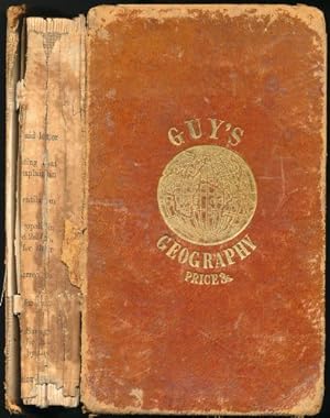
Guy's School Geography, on a new and easy plan: comprising not only a complete general description, but much topographical information, in a well digested order; exhibiting threee distinct parts, and yet forming one connected whole. Expressly adapted to every age and capacity, and to every class of learners, both in Ladies' and Gentlemen's schools. To which is now added a chapter on physical geo.
Verlag: London; Whittaker & Co. and Simpkin, Marshall, & Co., 1869
Anbieter: Sapience Bookstore, Hexham, Vereinigtes Königreich
Verkäuferbewertung 3 von 5 Sternen

EUR 30,30
EUR 20,43 Versand
Versand von Vereinigtes Königreich nach USAAnzahl: 1 verfügbar
In den WarenkorbHard. Zustand: Good-. Fold-out world map frontispiece and numerous further full-page and fold-out maps. (illustrator). Good-. Publishers full tan morrocco, worn, spine missing. Hinges cracked. viii and 244pp.
-
MAP OF THE WORLD AS PEOPLED BY THE DESCENDANTS OF NOAH - an Original Antique Coloured Map .
Sprache: Englisch
Erscheinungsdatum: 1870
Anbieter: K Books Ltd ABA ILAB, York, YORKS, Vereinigtes Königreich
Verbandsmitglied: ABA ILAB PBFA
Verkäuferbewertung 5 von 5 Sternen
EUR 24,05
EUR 22,76 Versand
Versand von Vereinigtes Königreich nach USAAnzahl: 1 verfügbar
In den WarenkorbNo Binding. Zustand: Very Good. A splendid original antique coloured Map .Mounted - matted - and ready to frame. Very good condition . Somewhat uncommon . A fine detailed map showing the world as peopled by the Descendants of Noah labelling the areas that were possessed by Shem, Ham and Japheth and their descendants, and with smaller areas delineated as peopled by the descendants of Magog, Gomer, Tubal & Meshek.
-
Map of World - an Original Engraving
Sprache: Englisch
Anbieter: K Books Ltd ABA ILAB, York, YORKS, Vereinigtes Königreich
Verbandsmitglied: ABA ILAB PBFA
Verkäuferbewertung 5 von 5 Sternen
EUR 24,05
EUR 22,76 Versand
Versand von Vereinigtes Königreich nach USAAnzahl: 1 verfügbar
In den WarenkorbNo Binding. Zustand: Very Good. A fine Engraving - printed circa 1870. Mounted and ready to frame. A fine opportunity to purchase an attractive and decorative engraved Map of World.
-
World Map - an Antique Coloured Map
Sprache: Englisch
Erscheinungsdatum: 1865
Anbieter: K Books Ltd ABA ILAB, York, YORKS, Vereinigtes Königreich
Verbandsmitglied: ABA ILAB PBFA
Verkäuferbewertung 5 von 5 Sternen
EUR 24,05
EUR 22,76 Versand
Versand von Vereinigtes Königreich nach USAAnzahl: 1 verfügbar
In den WarenkorbNo Binding. Zustand: Very Good. An original antique coloured Map . colouring contemporary Mounted - matted - and ready to frame. Very good condition - a splendid map - shows Australia, Asia. Africa etc.
-
HEMISPHERE MAP, DOUBLE HEMISHERE MAP OF THE WORLD SHOWING THE WESTERN AND EASTERN HEMISPHERES, CIRCA 1840
Sprache: Englisch
Verlag: H.G. COLLINS, London, 1840
Anbieter: K Books Ltd ABA ILAB, York, YORKS, Vereinigtes Königreich
Verbandsmitglied: ABA ILAB PBFA
Verkäuferbewertung 5 von 5 Sternen
Erstausgabe
EUR 47,98
EUR 22,76 Versand
Versand von Vereinigtes Königreich nach USAAnzahl: 1 verfügbar
In den WarenkorbSingle Sheet. Zustand: Very Good. No Jacket. First Edition. HEMISPHERE MAP, DOUBLE HEMISPHERE MAP OF THE WORLD SHOWING THE WESTERN AND EASTERN HEMISPHERES, CIRCA 1840 MEASURES 23 X 11 INCHES, DISPATCHED IN A STRONG TUBE, WELL PACKED, REASONABLY PRICED .
-
Classical World at the Time of Anacharsis - Antique Map, Contemporary Colouring 1798
Sprache: Englisch
Verlag: R Wilkinson, London, 1805
Anbieter: K Books Ltd ABA ILAB, York, YORKS, Vereinigtes Königreich
Verbandsmitglied: ABA ILAB PBFA
Verkäuferbewertung 5 von 5 Sternen
EUR 48,10
EUR 22,76 Versand
Versand von Vereinigtes Königreich nach USAAnzahl: 1 verfügbar
In den WarenkorbNo Binding. Zustand: Very Good. E Bourne (illustrator). A splendid original antique map of the world. Contemporary coloring and in excellent condition. Mounted and ready to frame. Extremely decorative and printed in 1805. Splendid and unusal map of the Middle East - entitled "Achaia, Exhibiting the Travels of Anacharis between the years CCCLXII & CCCLVI before Christ" (363-356 BC).
-
MAP OF THE WORLD. Antique Map
Sprache: Englisch
Verlag: GEORGE PHILIPS, 1850
Anbieter: K Books Ltd ABA ILAB, York, YORKS, Vereinigtes Königreich
Verbandsmitglied: ABA ILAB PBFA
Verkäuferbewertung 5 von 5 Sternen
EUR 48,10
EUR 22,76 Versand
Versand von Vereinigtes Königreich nach USAAnzahl: 1 verfügbar
In den WarenkorbNo Binding. Zustand: Very Good. A vg copy of an attractive coloured engraving showing Mercator's projection of the World.
-
World Map - Primitive an Antique Hand Coloured Plan
Sprache: Englisch
Erscheinungsdatum: 1850
Anbieter: K Books Ltd ABA ILAB, York, YORKS, Vereinigtes Königreich
Verbandsmitglied: ABA ILAB PBFA
Verkäuferbewertung 5 von 5 Sternen
EUR 30,06
EUR 22,76 Versand
Versand von Vereinigtes Königreich nach USAAnzahl: 1 verfügbar
In den WarenkorbNo Binding. Zustand: Very Good. A fine original antique hand coloured Map. .Colouring not contemporary but delicately and expertly executed . . . . Very good condition, . A splendid opportunity to acquire an antique original map - decorative, attractive and scarce . A splendid map -circa 1850 - Anglo Saxon Map of the Tenth Century - rather unusual.
-
Tenth Century World Map an Original Engraving Printed in 1845
Sprache: Englisch
Erscheinungsdatum: 1845
Anbieter: K Books Ltd ABA ILAB, York, YORKS, Vereinigtes Königreich
Verbandsmitglied: ABA ILAB PBFA
Verkäuferbewertung 5 von 5 Sternen
EUR 30,06
EUR 22,76 Versand
Versand von Vereinigtes Königreich nach USAAnzahl: 1 verfügbar
In den WarenkorbNo Binding. Zustand: Very Good. An antique original engraving printed in 1845 .Hand coloured - not contemporary but expertly and delicately executed Mounted - matted - and ready to frame. Very good condition and somewhat uncommon. Shows a tenth century Anglo Saxon Map of the World - a rather curious item.
-
Map of the World - 1830 - an Original Antique Engraving
Sprache: Englisch
Erscheinungsdatum: 1840
Anbieter: K Books Ltd ABA ILAB, York, YORKS, Vereinigtes Königreich
Verbandsmitglied: ABA ILAB PBFA
Verkäuferbewertung 5 von 5 Sternen
EUR 30,06
EUR 22,76 Versand
Versand von Vereinigtes Königreich nach USAAnzahl: 1 verfügbar
In den WarenkorbNo Binding. Zustand: Very Good. An original hand-coloured antique engraving printed circa 1840. Hand-colouring contemporary. Mounted/matted and ready to frame. A fine opportunity to purchase an attractive and decorative engraving - Showing a Map of Map of the World - 1830.
-
Map of the World - Exhibiting the Physical Features, Wind, Rain Etc - an Original Antique Engraving
Sprache: Englisch
Erscheinungsdatum: 1850
Anbieter: K Books Ltd ABA ILAB, York, YORKS, Vereinigtes Königreich
Verbandsmitglied: ABA ILAB PBFA
Verkäuferbewertung 5 von 5 Sternen
EUR 30,06
EUR 22,76 Versand
Versand von Vereinigtes Königreich nach USAAnzahl: 1 verfügbar
In den WarenkorbNo Binding. Zustand: Very Good. An original hand-coloured antique engraved map, printed circa 1850. Hand-colouring contemporary. Mounted/matted and ready to frame. A fine opportunity to purchase an attractive and decorative engraving of a Map of the World - Exhibiting the Physical Features, Wind, Rain Etc.
-

Zustand: Sehr gut. Zustand: Sehr gut | Seiten: 120 | Sprache: Englisch | Produktart: Bücher | Keine Beschreibung verfügbar.
-
Imago Mundi The Journal of the International Society for the History of Cartography Volume 44
Sprache: Englisch
Verlag: Imago Mundi, Ltd., London, 1992
ISBN 10: 0905776178 ISBN 13: 9780905776170
Hardcover. Zustand: Very Good. 4to (30.5 cm), frontispiece in color, 178 pp. Publisher's cloth, gilt-lettered spine and front board (binding slightly rubbed and stained, bookplate tipped in verso of the title page). Contents include articles: "A Tibetan map of lHo-kha in the South-Eastern Himalayan borderlands of Tibet" by Toni Huber; "The Aslake world map" by Peter M. Barber & Michelle P. Brown; "Paolo Forlani: Compiler, engraver, printer, or publisher?" by David Woodward; "Mapping new worlds: Culture and cartography in sixteenth?century Venice" by Denis Cosgrove; "L'émergence des nouvelles cartes marines: L'oeuvre de Beautemps?Beaupré ŕ la fin du XVIIIčme et au début du XIXčme sičcle" by Olivier Chapuis; "Medieval Hebrew manuscript maps" by E. Wajntraub & G. Wajntraub; "The Royal Geographical Society, E. G. Ravenstein, and a map of eastern equatorial Africa-1877-1883" by Sanford H. Bederman; reports and articles, chronicle for 1991, book reviews.


