
Gesamtpreis (1 Artikel Artikel):
Versandziel:

woldermann (8 Ergebnisse)
Direkt zu den wichtigsten Suchergebnissen
Suchfilter
Produktart
- Alle Product Types
- Bücher (2)
- Magazine & Zeitschriften (Keine weiteren Ergebnisse entsprechen dieser Verfeinerung)
- Comics (Keine weiteren Ergebnisse entsprechen dieser Verfeinerung)
- Noten (Keine weiteren Ergebnisse entsprechen dieser Verfeinerung)
- Kunst, Grafik & Poster (Keine weiteren Ergebnisse entsprechen dieser Verfeinerung)
- Fotografien (Keine weiteren Ergebnisse entsprechen dieser Verfeinerung)
- Karten (6)
- Manuskripte & Papierantiquitäten (Keine weiteren Ergebnisse entsprechen dieser Verfeinerung)
Zustand Mehr dazu
- Neu (Keine weiteren Ergebnisse entsprechen dieser Verfeinerung)
- Wie Neu, Sehr Gut oder Gut Bis Sehr Gut (Keine weiteren Ergebnisse entsprechen dieser Verfeinerung)
- Gut oder Befriedigend (6)
- Ausreichend oder Schlecht (Keine weiteren Ergebnisse entsprechen dieser Verfeinerung)
- Wie beschrieben (2)
Einband
- alle Einbände
- Hardcover (2)
- Softcover (Keine weiteren Ergebnisse entsprechen dieser Verfeinerung)
Weitere Eigenschaften
- Erstausgabe (1)
- Signiert (Keine weiteren Ergebnisse entsprechen dieser Verfeinerung)
- Schutzumschlag (Keine weiteren Ergebnisse entsprechen dieser Verfeinerung)
- Angebotsfoto (7)
Sprache (1)
Preis
- Beliebiger Preis
- Weniger als EUR 20 (Keine weiteren Ergebnisse entsprechen dieser Verfeinerung)
- EUR 20 bis EUR 45 (Keine weiteren Ergebnisse entsprechen dieser Verfeinerung)
- Mehr als EUR 45
Gratisversand
- Kostenloser Versand nach USA (Keine weiteren Ergebnisse entsprechen dieser Verfeinerung)
Land des Verkäufers
Verkäuferbewertung
-

Zuverlässige Nachricht von der Sackschen Familien-Stiftung zu Glogau zum Unterricht der Stiftungs-Berechtigten bei Gelegenheit der zu errichtenden Vergleiche und Familien-Schlüsse und eines neuen Stiftungs-Reglements. [Und Nachtrag].
Verlag: Glogau Günter, 1828
Anbieter: Antiquariat C. Hoffmeister, Wolfenbüttel, Deutschland
Verkäuferbewertung 4 von 5 Sternen

[2. A.]. [2. A.]. 8vo. 220, 145 S. Mod. Lwd. mit Deckel- Rückentitel. Seltene Quelle zu der noch heute existierenden Stiftung. - 2x gestempelt, vereinzelt gering stockfl. {Dazu}: Der Familienrat der Hofrat Simon Heinrich Sack'schen Familienstiftung (Hrsg.). Das Silberne Buch der Familie Sack. 4. Auflage. Band "Genealogie".XLVII, 359 S. Mit 1 farb. Wappentafel. OLwd. 0,800 gr.
-
Plastischer Schul-Atlas über alle Theile der Erde in 24 Karten nach Reliefs und Zeichnungen. Ausgabe D.
Verlag: Leipzig, P. Eckerlein 1879., 1879
Anbieter: Antiquariat Löcker, Wien, Österreich
Verbandsmitglied: GIAQ ILAB VDA VDAO
Verkäuferbewertung 5 von 5 Sternen

Erstausgabe
Erste Ausgabe. Espenhorst II, 1117ff.; Kretschmer, Lex. 660. Seltener Schulatlas mit Erdteilkarten, verschiedenen Deutschlandkarten, einer Karte der Alpen, sowie Karten mehrerer europäischer Staaten, jeweils 1 Karte von Asien, Afrika, Nordamerika, Südamerika, Australien. Die Karten sind in einem - um 1830 entwickelten - als Geomontographie bezeichneten, Prägeverfahren hergestellt. Die geprägten Karten sind an den Rändern - zum Schutz der Reliefs - bombiert, - Titelbl. mit kl. priv. Eignerstempel, etwas gebräunt, ansonsten in tadellosem Zustand. Die beiden Karten Westdeutschland und Ostdeutschland sind jeweils 2 x vorhanden. / 24 (+ 2 duplicates) coloured lithographed maps, of which 22 are in three-dimensional relief-technique. 33 x 27,5 cm. Tit., 24 farbige Karten, darunter 22 dreidimensionale Karten in plastischem Prägedruck. Dunkelgrüne OLn.-Kassette mit Schließband, Vorderdeckel gold- u. schwarzgeprägt, Kanten leicht berieben.
-
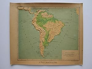
Süd-Amerika
Verlag: P. Eckerlein, Leipzig, 1879
Anbieter: Angelika C. J. Friebe Ltd. - MapWoman, Dorking, Vereinigtes Königreich
Verkäuferbewertung 5 von 5 Sternen
Karte
EUR 178,01
EUR 23,04 Versand
Versand von Vereinigtes Königreich nach USAAnzahl: 1 verfügbar
In den WarenkorbNo Binding. Zustand: Very Good. colour printed and embossed map on thick paper. overall 26 x 30,5 cm, evenly browned, occ. some tiny marginal tears, occ. some faint foxing, 2 bend corners, o/w vg cond. A very rare relief map from 'Plastischer Schulatlas'; the reliefs were created by Lieutenant G. Woldermann and published by P. Eckerlein though some of the maps as well as the binding bear various publishers. The maps are printed in a relief technique Geomontography, a printing method that combined embossing and colour printing, and was mainly applied to the production of maps. The German printer Georg Michael Bauerkeller (1805 1886) and his half-brother Georg Leonhart Bauerkeller developed this technique and applied for a patent in 1839. Geomontography is mainly used for the teaching of the blind.
-
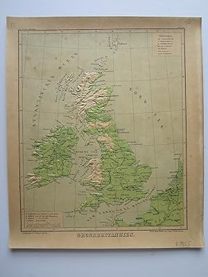
Grossbritannien
Verlag: P. Eckerlein, Leipzig, 1879
Anbieter: Angelika C. J. Friebe Ltd. - MapWoman, Dorking, Vereinigtes Königreich
Verkäuferbewertung 5 von 5 Sternen
Karte
EUR 178,01
EUR 23,04 Versand
Versand von Vereinigtes Königreich nach USAAnzahl: 1 verfügbar
In den WarenkorbNo Binding. Zustand: Very Good. colour printed and embossed map on thick paper. overall 26 x 30,5 cm, evenly browned, occ. some tiny marginal tears, occ. some faint foxing, o/w vg cond. A very rare relief map from Plastischer Schulatlas ; the reliefs were created by Lieutenant G. Woldermann and published by P. Eckerlein though some of the maps as well as the binding bear various publishers. The maps are printed in a relief technique Geomontography, a printing method that combined embossing and colour printing, and was mainly applied to the production of maps. The German printer Georg Michael Bauerkeller (1805 1886) and his half-brother Georg Leonhart Bauerkeller developed this technique and applied for a patent in 1839. Geomontography is mainly used for the teaching of the blind.
-
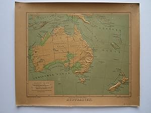
Australien
Verlag: P. Eckerlein, Leipzig, 1879
Anbieter: Angelika C. J. Friebe Ltd. - MapWoman, Dorking, Vereinigtes Königreich
Verkäuferbewertung 5 von 5 Sternen
Karte
EUR 237,34
EUR 23,04 Versand
Versand von Vereinigtes Königreich nach USAAnzahl: 1 verfügbar
In den WarenkorbNo Binding. Zustand: Very Good. colour printed and embossed map on thick paper. overall 26 x 30,5 cm, evenly browned, occ. some tiny marginal tears, occ. some faint foxing, o/w vg cond.- A very rare relief map from Plastischer Schulatlas ; the reliefs were created by Lieutenant G. Woldermann and published by P. Eckerlein though some of the maps as well as the binding bear various publishers.- The maps are printed in a relief technique Geomontography, a printing method that combined embossing and colour printing, and was mainly applied to the production of maps. The German printer Georg Michael Bauerkeller (1805 1886) and his half-brother Georg Leonhart Bauerkeller developed this technique and applied for a patent in 1839. Geomontography is mainly used for the teaching of the blind.
-
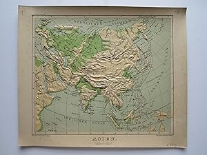
Asien
Verlag: P. Eckerlein, Leipzig, 1879
Anbieter: Angelika C. J. Friebe Ltd. - MapWoman, Dorking, Vereinigtes Königreich
Verkäuferbewertung 5 von 5 Sternen
Karte
EUR 237,34
EUR 23,04 Versand
Versand von Vereinigtes Königreich nach USAAnzahl: 1 verfügbar
In den WarenkorbNo Binding. Zustand: Very Good. colour printed and embossed map on thick paper. overall 26 x 30,5 cm, evenly browned, occ. some tiny marginal tears, occ. some faint foxing, o/w vg cond.- A very rare relief map from Plastischer Schulatlas ; the reliefs were created by Lieutenant G. Woldermann and published by P. Eckerlein though some of the maps as well as the binding bear various publishers.- The maps are printed in a relief technique Geomontography, a printing method that combined embossing and colour printing, and was mainly applied to the production of maps. The German printer Georg Michael Bauerkeller (1805 1886) and his half-brother Georg Leonhart Bauerkeller developed this technique and applied for a patent in 1839. Geomontography is mainly used for the teaching of the blind.
-
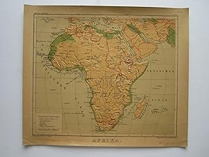
Afrika
Verlag: P. Eckerlein, Leipzig, 1879
Anbieter: Angelika C. J. Friebe Ltd. - MapWoman, Dorking, Vereinigtes Königreich
Verkäuferbewertung 5 von 5 Sternen
Karte
EUR 237,34
EUR 23,04 Versand
Versand von Vereinigtes Königreich nach USAAnzahl: 1 verfügbar
In den WarenkorbNo Binding. Zustand: Very Good. colour printed and embossed map on thick paper. overall 26 x 30,5 cm, evenly browned, occ. some tiny marginal tears, occ. some faint foxing, 2 bend corners, o/w vg cond.- A very rare relief map from 'Plastischer Schulatlas'; the reliefs were created by Lieutenant G. Woldermann and published by P. Eckerlein though some of the maps as well as the binding bear various publishers.- The maps are printed in a relief technique Geomontography, a printing method that combined embossing and colour printing, and was mainly applied to the production of maps. The German printer Georg Michael Bauerkeller (1805 1886) and his half-brother Georg Leonhart Bauerkeller developed this technique and applied for a patent in 1839. Geomontography is mainly used for the teaching of the blind.
-
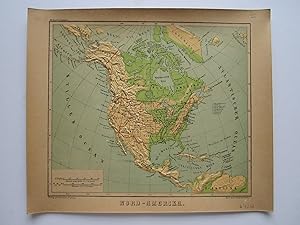
Nord- Amerika
Verlag: P. Eckerlein, Leipzig, 1879
Anbieter: Angelika C. J. Friebe Ltd. - MapWoman, Dorking, Vereinigtes Königreich
Verkäuferbewertung 5 von 5 Sternen
Karte
EUR 237,34
EUR 23,04 Versand
Versand von Vereinigtes Königreich nach USAAnzahl: 1 verfügbar
In den WarenkorbNo Binding. Zustand: Very Good. colour printed and embossed map on thick paper. overall 26 x 30,5 cm, evenly browned, occ. some tiny marginal tears, occ. some faint foxing, o/w vg cond. A very rare relief map from 'Plastischer Schulatlas'; the reliefs were created by Lieutenant G. Woldermann and published by P. Eckerlein though some of the maps as well as the binding bear various publishers. The maps are printed in a relief technique Geomontography, a printing method that combined embossing and colour printing, and was mainly applied to the production of maps. The German printer Georg Michael Bauerkeller (1805 1886) and his half-brother Georg Leonhart Bauerkeller developed this technique and applied for a patent in 1839. Geomontography is mainly used for the teaching of the blind.

