

Gesamtpreis (1 Artikel Artikel):
Versandziel:

william mount john page (14 Ergebnisse)
Direkt zu den wichtigsten Suchergebnissen
Suchfilter
Produktart
- Alle Product Types
- Bücher (1)
- Magazine & Zeitschriften (Keine weiteren Ergebnisse entsprechen dieser Verfeinerung)
- Comics (Keine weiteren Ergebnisse entsprechen dieser Verfeinerung)
- Noten (Keine weiteren Ergebnisse entsprechen dieser Verfeinerung)
- Kunst, Grafik & Poster (13)
- Fotografien (Keine weiteren Ergebnisse entsprechen dieser Verfeinerung)
- Karten (Keine weiteren Ergebnisse entsprechen dieser Verfeinerung)
- Manuskripte & Papierantiquitäten (Keine weiteren Ergebnisse entsprechen dieser Verfeinerung)
Zustand Mehr dazu
- Neu (Keine weiteren Ergebnisse entsprechen dieser Verfeinerung)
- Wie Neu, Sehr Gut oder Gut Bis Sehr Gut (Keine weiteren Ergebnisse entsprechen dieser Verfeinerung)
- Gut oder Befriedigend (14)
- Ausreichend oder Schlecht (Keine weiteren Ergebnisse entsprechen dieser Verfeinerung)
- Wie beschrieben (Keine weiteren Ergebnisse entsprechen dieser Verfeinerung)
Einband
- alle Einbände
- Hardcover (1)
- Softcover (Keine weiteren Ergebnisse entsprechen dieser Verfeinerung)
Weitere Eigenschaften
- Erstausgabe (1)
- Signiert (Keine weiteren Ergebnisse entsprechen dieser Verfeinerung)
- Schutzumschlag (Keine weiteren Ergebnisse entsprechen dieser Verfeinerung)
- Angebotsfoto (14)
Sprache (1)
Preis
- Beliebiger Preis
- Weniger als EUR 20 (Keine weiteren Ergebnisse entsprechen dieser Verfeinerung)
- EUR 20 bis EUR 45 (Keine weiteren Ergebnisse entsprechen dieser Verfeinerung)
- Mehr als EUR 45
Gratisversand
Land des Verkäufers
Verkäuferbewertung
-
The English pilot. The fourth book. Describing The West-Indian navigation, from Hudson's Bay to the River Amazones. Particularly delineating The Coasts, Capes, Headlands, Rivers, Bays, Roads, Havens, Harbours, Streights, Rocks, Sands, Shoals, Banks, Depths of Water, and Anchorage, with all the Islands therein; as Jamaica, Cuba, Hispaniola, Barbadoes, Antiqua, Bermudas, Porto Rico, and the rest of the Caribbee and Bahama Islands. Also A New Description of Newfoundland, New England, New York, East and West New Jersey, Dellawar Bay, Virginia, Maryland, Carolina, &c. .
Verlag: J. Mount, T. Page, W. Mount and T. Page, London, 1780
Erstausgabe
Hardcover. Zustand: Good. A SHIPBOARD COPY OF THE ENGLISH PILOT USED BY AMERICAN CAPTAINS IN THE EARLY REPUBLIC -- FROM THE LIBRARY OF JOHN GOLDEN. London: J. Mount, T. Page, W. Mount and T. Page, 1780. Thirty-third edition (Verner). Folio (18 ¾" x 12 5/16", 477mm x 312mm). [Full collation available.] With 25 engraved charts, of which 8 are double, 12 folding and 4 integral with the text; and many woodcut charts and coastal profiles integral with the text. Bound in contemporary speckled sheep (re-backed) with a blind roll border. On the spine, five raised bands. Title green to red sheep in the second panel. All edges of the text-block sprinkled brown. Re-backed and re-cornered. A large (9 3/4", 250mm diameter) scorch-ring to the front board with soiling generally. Joints strengthened with Japanese paper, along with some similar repairs to the edges of a handful of leaves. Internally tanned and offset, with a little foxing and soiling. A few splits to the mapsheets, two with repairs. Large filled losses to the first and rear free end-papers. Ink ownership inscription of "John Tremells his Book Dated at Sea 1791/ Jno Tremells Cap.t Caleb Hathaway Master of the Brig Nancy" as well as verse, sums, lists, pen trials etc. to the rear binder's blank and end-papers (see below). Presented with two manuscript fragments (one a receipt from Tremells). Books of coastal charts and profiles had been published by the Dutch since the XVIc. Lucas Janszoon Waghenaer was the pioneer of the genre, such that "Waggoner" became the English term for coastal atlases, an early proprietary eponym. The English, great XVIIc enemies of the Dutch, began to catch up with John Seller's English Pilot series, beginning in 1671. Seller was named in that year hydrographer to Charles II, and began in earnest to chart the coasts of Britain (the first book), the Continent (the second), the Orient (third), America (fourth, first published 1689) and Africa (fifth). Cumming in his British Maps of Colonial America calls it "the first significant collection of charts exclusively of the American coasts to be published in England. . . The English Pilot: The Fourth Book must have been a godsend. . . to the navigator of American waters in that period, it was his Bible. Whatever its shortcomings, there was really no substitute, no real competitor, for over sixty years" (p. 39). Coolie Verner published "A carto-bibliographical study of The English Pilot. The Fourth Book" (1960), in which he traced 37 editions -- modern bibliographers might call some of them issues -- of a shifting and growing work that was published for over a century (the final edition was in 1794). From the 18 charts of the first edition the present work has grown to 25. Bibliographers are keen to assert the rarity of the work, though that is not entirely borne out by the market. That said, of this 1780 edition, there are just 9 examples in institutional collections per OCLC. What distinguishes the present volume is the rich set of annotations by an early owner: John Tremells, an American sailor active in the 1790's and 1800's, who received and doubtless used the volume while at sea. The ownership inscription may indicate that it was given to Tremells by Captain Caleb Hathaway, master of the brig Nancy in 1795. By 1798 Tremells was commanding the schooner Swift as a merchantman in the "Quasi-War" between the U.S. and France, principally over Caribbean maritime rights, which was a turning-point in the buildup of the U.S. Navy. Indeed, it seems that Hathaway -- and perhaps Tremells as well -- was in Philadelphia; several of their circle corresponded with Alexander Hamilton and Thomas Jefferson. Arader has acquired the present volume twice: first at Swann (6 December 2007, lot 20) and again at the Sotheby's New York sale of John Golden (22 November 2022, lot 39); Golden purchased the book from Arader in October 2010. Verner, A carto-bibliographical study of The English Pilot. The Fourth Book 33.
-
![Bild des Verkäufers für A Description of the Coast of Spain, 11 - Altier Bay [Bahía de Altea] zum Verkauf von Frame](https://pictures.abebooks.com/inventory/md/md32134217274.jpg)
A Description of the Coast of Spain, 11 - Altier Bay [Bahía de Altea]
Verlag: Londres, 1736
Kunst / Grafik / Poster
Zustand: ACEPTABLE. [Una] Carta marina representando las zonas portuarias de Altea, en el Levante,obra deWilliam yJohn Mount, and Thomas Page. En los mapas de esta obra, los contornos costeros están detallados con indicaciones de bahías, cabos y estuarios, sin apenas representación de elevaciones terrestres. Los topónimos están escritos en inglés, lo que sugiere su creación para un público anglófono, probablemente británico. Título completo: "A large chart of Port Maon on the Island Minorca on the Mediterranean. The English pilot Part III [.] Mediterranean. M, DCC,L (1750). (to accompany) The English pilot for the Southern navigation [.] London : Printed for J. Mount and T. Page, on Tower Hill. M,DCC,LII (1752).". El "English Pilot"fue un atlas de cartas náuticas publicado en varias ediciones entre 1671 y 1803. La edición de 1752 fue impresa en Londres por John Mount y Thomas Page. ["By John Gaudy."] . Formato (cm): 25 aprox.x15.
-
![Bild des Verkäufers für Almarie Bay [Bahía de Almería] zum Verkauf von Frame](https://pictures.abebooks.com/inventory/md/md32134210619.jpg)
Zustand: ACEPTABLE. [Una] Carta marina representando las zona de la bahía de Almería, en Andalucía,obra deWilliam yJohn Mount, and Thomas Page. En los mapas de esta obra, los contornos costeros están detallados con indicaciones de bahías, cabos y estuarios, sin apenas representación de elevaciones terrestres. Los topónimos están escritos en inglés, lo que sugiere su creación para un público anglófono, probablemente británico. Título completo: "A large chart of Port Maon on the Island Minorca on the Mediterranean. The English pilot Part III [.] Mediterranean. M, DCC,L (1750). (to accompany) The English pilot for the Southern navigation [.] London : Printed for J. Mount and T. Page, on Tower Hill. M,DCC,LII (1752).". El "English Pilot"fue un atlas de cartas náuticas publicado en varias ediciones entre 1671 y 1803. La edición de 1752 fue impresa en Londres por John Mount y Thomas Page. ["By John Gaudy."] . Formato (cm): 25 aprox.x20.
-
![Bild des Verkäufers für Gibralter Bay [Bahía de Gibraltar] zum Verkauf von Frame](https://pictures.abebooks.com/inventory/md/md32134204850.jpg)
Zustand: ACEPTABLE. [Una] Carta marina representando las zona de la bahía de Gibraltar,obra deWilliam yJohn Mount, and Thomas Page. En los mapas de esta obra, los contornos costeros están detallados con indicaciones de bahías, cabos y estuarios, sin apenas representación de elevaciones terrestres. Los topónimos están escritos en inglés, lo que sugiere su creación para un público anglófono, probablemente británico. Título completo: "A large chart of Port Maon on the Island Minorca on the Mediterranean. The English pilot Part III [.] Mediterranean. M, DCC,L (1750). (to accompany) The English pilot for the Southern navigation [.] London : Printed for J. Mount and T. Page, on Tower Hill. M,DCC,LII (1752).". El "English Pilot"fue un atlas de cartas náuticas publicado en varias ediciones entre 1671 y 1803. La edición de 1752 fue impresa en Londres por John Mount y Thomas Page. ["By John Gaudy."] . Formato (cm): 25 aprox.x20.
-

Zustand: ACEPTABLE. [Una] Carta marina representando la costa nortede África, especialmente la zona de la actual Argelia,obra deWilliam yJohn Mount, and Thomas Page. Está orientado a los navegantes, con líneas de rumbo radiales que convergen en puntos específicos (rosas de los vientos), un recurso típico para la navegación marítima. El grabado es meticuloso y combina la cartografía con la estética ornamental: el título está enmarcado en una cartela barroca decorativa, destacando el propósito artístico y funcional. Los contornos costeros están detallados con indicaciones de bahías, cabos y estuarios, sin representación de elevaciones terrestres. Los topónimos están escritos en inglés, lo que sugiere su creación para un público anglófono, probablemente británico. Título completo:"The Sea Coast of BARBARY From Cape de Tenes to Cape de Rofa". Formato (cm): 54x44.
-

Barcelona ; The Harbour of Malta ; A large Chart of Port Maon on the Island Minorca on the Mediterranean
Verlag: Londres, 1736
Kunst / Grafik / Poster
Zustand: ACEPTABLE. [Una] Carta marina representando las zonas portuarias de Barcelona, Malta y Mahon,obra deWilliam yJohn Mount, and Thomas Page. Las tres zonas están separadas por una filigrana vegetal. Los contornos costeros están detallados con indicaciones de bahías, cabos y estuarios, sin apenas representación de elevaciones terrestres. Los topónimos están escritos en inglés, lo que sugiere su creación para un público anglófono, probablemente británico. Título completo: "A large chart of Port Maon on the Island Minorca on the Mediterranean. The English pilot Part III [.] Mediterranean. M, DCC,L (1750). (to accompany) The English pilot for the Southern navigation [.] London : Printed for J. Mount and T. Page, on Tower Hill. M,DCC,LII (1752).". El "English Pilot"fue un atlas de cartas náuticas publicado en varias ediciones entre 1671 y 1803. La edición de 1752 fue impresa en Londres por John Mount y Thomas Page. ["By John Gaudy."] . Formato (cm): 44x57.
-
![Bild des Verkäufers für A Chart of the Sea Coast of Spain [Desde el Estrecho de Gibraltar hasta el Cabo de Gata] zum Verkauf von Frame](https://pictures.abebooks.com/inventory/md/md32082545365.jpg)
A Chart of the Sea Coast of Spain [Desde el Estrecho de Gibraltar hasta el Cabo de Gata]
Verlag: Londres, 1736
Kunst / Grafik / Poster
Zustand: ACEPTABLE. [Una] Carta marina representando la costa sureste de Estaña, y noroeste de África,obra deWilliam yJohn Mount, and Thomas Page. Está orientado a los navegantes, con líneas de rumbo radiales que convergen en puntos específicos (rosas de los vientos), un recurso típico para la navegación marítima. El grabado es meticuloso y combina la cartografía con la estética ornamental: el título está enmarcado en una cartela barroca decorativa, destacando el propósito artístico y funcional. Los contornos costeros están detallados con indicaciones de bahías, cabos y estuarios, sin representación de elevaciones terrestres. Los topónimos están escritos en inglés, lo que sugiere su creación para un público anglófono, probablemente británico. Título completo: "A Chart of the Sea Coast of SPAIN From the Straits mouth to C de Gat And of the Sea Coast of BARBARY From the Straits mouth to C de Hone". Formato (cm): 54x44.
-
![Bild des Verkäufers für A Chart of the Straits of Gibralter [Estrecho de Gibraltar] zum Verkauf von Frame](https://pictures.abebooks.com/inventory/md/md32082546110.jpg)
A Chart of the Straits of Gibralter [Estrecho de Gibraltar]
Verlag: Londres, 1736
Kunst / Grafik / Poster
Zustand: ACEPTABLE. [Una] Carta marina representando con gran detalle el Estrecho de Gibraltar,obra deWilliam yJohn Mount, and Thomas Page. Está orientado a los navegantes, con líneas de rumbo radiales que convergen en puntos específicos (rosas de los vientos), un recurso típico para la navegación marítima. El grabado es meticuloso y combina la cartografía con la estética ornamental: el título está enmarcado en una cartela barroca decorativa, destacando el propósito artístico y funcional. Los contornos costeros están detallados con indicaciones de bahías, cabos y estuarios, sin representación de elevaciones terrestres. Los topónimos están escritos en inglés, lo que sugiere su creación para un público anglófono, probablemente británico. Formato (cm): 54x44.
-
![Bild des Verkäufers für A Chart of the Sea Coast of Spain [Desde el Cabo de Gata hasta Javea - Murcia] zum Verkauf von Frame](https://pictures.abebooks.com/inventory/md/md32082546109.jpg)
A Chart of the Sea Coast of Spain [Desde el Cabo de Gata hasta Javea - Murcia]
Verlag: Londres, 1736
Kunst / Grafik / Poster
Zustand: ACEPTABLE. [Una] Carta marina representando la costa sureste de Estaña, y noroeste de África, especialmente la zona de la actual Murcia,obra deWilliam yJohn Mount, and Thomas Page. Está orientado a los navegantes, con líneas de rumbo radiales que convergen en puntos específicos (rosas de los vientos), un recurso típico para la navegación marítima. El grabado es meticuloso y combina la cartografía con la estética ornamental: el título está enmarcado en una cartela barroca decorativa, destacando el propósito artístico y funcional. Los contornos costeros están detallados con indicaciones de bahías, cabos y estuarios, sin representación de elevaciones terrestres. Los topónimos están escritos en inglés, lo que sugiere su creación para un público anglófono, probablemente británico. Título completo:"A Chart of the Sea-Coast of SPAIN From Cape de Gata to Cape S. Martin. And of the Sea-Coast of BARBARY From Cape de Hone to Cape de Tenes". Formato (cm): 54x44.
-

A Chart of the Sea Coasts of Barbaria with the Western, Canaria, & Cape de Verd, Isles
Verlag: Londres, 1736
Kunst / Grafik / Poster
Zustand: ACEPTABLE. [Una] Carta marina representando la costa noroeste de África y las Islas Canarias, obra deWilliam yJohn Mount, and Thomas Page. Está orientado a los navegantes, con líneas de rumbo radiales que convergen en puntos específicos (rosas de los vientos), un recurso típico para la navegación marítima. El grabado es meticuloso y combina la cartografía con la estética ornamental: el título está enmarcado en una cartela barroca decorativa, destacando el propósito artístico y funcional. Los contornos costeros están detallados con indicaciones de bahías, cabos y estuarios, sin representación de elevaciones terrestres. Los topónimos están escritos en inglés, lo que sugiere su creación para un público anglófono, probablemente británico. Inserta detalle de Madeira y de Tenerife El título completo ha sido eliminado de la orla. Formato (cm): 54x44.
-

A Chart of the Sea Coasts of Algarve and Andalusia (London)
Verlag: Londres, 1736
Kunst / Grafik / Poster
Zustand: ACEPTABLE. [Una] Carta marina representando las costa del norte de España de Vizcaya y Galicia, obra deWilliam yJohn Mount, and Thomas Page. Está orientado a los navegantes, con líneas de rumbo radiales que convergen en puntos específicos (rosas de los vientos), un recurso típico para la navegación marítima. El grabado es meticuloso y combina la cartografía con la estética ornamental: el título está enmarcado en una cartela barroca decorativa, destacando el propósito artístico y funcional. Los contornos costeros están detallados con indicaciones de bahías, cabos y estuarios, sin representación de elevaciones terrestres. Los topónimos están escritos en inglés, lo que sugiere su creación para un público anglófono, probablemente británico. Inserta detalle de la bahía de Cádiz, Título completo: "A Chart of the Sea Coasts of Algrave and Andalusia Between cape St. Vincent and the Strait of Gibralter and C. Spartel Sold by W. Mount & T. Page at the Postern on Great Tower Hill London.". Formato (cm): 54x44.
-

A Chart of the Sea of the Coasts Biscay and Gallicia Betwen Cape Machichaca and Cape de Pinas and from Cape de Pinas to Cape de Finisterre (London)
Verlag: Londres, 1736
Kunst / Grafik / Poster
Zustand: ACEPTABLE. [Una] Carta marina representando las costa del norte de España de Vizcaya y Galicia, obra deWilliam yJohn Mount, and Thomas Page. Está orientado a los navegantes, con líneas de rumbo radiales que convergen en puntos específicos (rosas de los vientos), un recurso típico para la navegación marítima. El mapa utiliza un diseño en dos secciones horizontales, dividiendo el territorio costero para ofrecer mayor detalle, abarcando desde el cabo Machichaco hasta el cabo de Finisterre. El grabado es meticuloso y combina la cartografía con la estética ornamental: el título está enmarcado en una cartela barroca decorativa, destacando el propósito artístico y funcional. Los contornos costeros están detallados con indicaciones de bahías, cabos y estuarios, sin representación de elevaciones terrestres. Los topónimos están escritos en inglés, lo que sugiere su creación para un público anglófono, probablemente británico. Incluye: Galicia, Asturias y País Vasco (Bilbao, Castro, Laredo, Llanes, Avilés, Luarca, Castropol, Rivadeo, Estaca de Vares, cabo Ortegal, Ferrol, Coruña, Camariñas, etc.). Título completo: "A Chart of the Sea Coasts Biscay and Gallicia between Cape Machichaco and Cape St. Pinas, and from Cape de Pinas to Cape de Finisterre. Sold by R. Mount at the Postern on Great Tower Hill, London.". (c.131) Formato (cm): 54x44.
-

A Chart of the Sea Coast from England to the Streights
Verlag: Londres, 1736
Kunst / Grafik / Poster
Zustand: ACEPTABLE. [Una] Carta marina representando la costa suroeste de Europa, desde el sur de Inglaterra hasta Gibraltar, pasando por Francia y casi toda la Península Ibérica,obra deWilliam yJohn Mount, and Thomas Page. Está orientado a los navegantes, con líneas de rumbo radiales que convergen en puntos específicos (rosas de los vientos), un recurso típico para la navegación marítima. El grabado es meticuloso y combina la cartografía con la estética ornamental: el título está enmarcado en una cartela barroca decorativa, destacando el propósito artístico y funcional. Los contornos costeros están detallados con indicaciones de bahías, cabos y estuarios, sin representación de elevaciones terrestres. Los topónimos están escritos en inglés, lo que sugiere su creación para un público anglófono, probablemente británico. Inserta detalle del Puerto de Cádiz. Título completo: "A Chart of the Sea Coast from England to the Streights, Sold by Ric. Mount & Tho. Page at (?) Row on Tower Hill.". (2: gal + and) Formato (cm): 54x44.
-
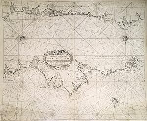
A Chart of the Sea Coasts Biscay and Gallicia Betwen Cape Machichaca and Cape de Pinas and from Cape de Pinas to Cape de Finisterre (Dublin)
Verlag: Dublin, 1749
Kunst / Grafik / Poster
Zustand: ACEPTABLE. [Una] Carta marina,rara estampación extraoficialpor Grierson de la carta de Mount and Page. Pequeñas manchas, restaurado con soporte de tela. Incluye: Galicia, Asturias y País Vasco (Bilbao, Castro, Laredo, Llanes, Avilés, Luarca, Castropol, Rivadeo, Estaca de Vares, cabo Ortegal, Ferrol, Coruña, Camariñas, etc.). Formato (cm): 54x44.

