
Gesamtpreis (1 Artikel Artikel):
Versandziel:

whittle james (55 Ergebnisse)
Direkt zu den wichtigsten Suchergebnissen
Suchfilter
Produktart
- Alle Product Types
- B¸cher (32)
- Magazine & Zeitschriften (Keine weiteren Ergebnisse entsprechen dieser Verfeinerung)
- Comics (Keine weiteren Ergebnisse entsprechen dieser Verfeinerung)
- Noten (Keine weiteren Ergebnisse entsprechen dieser Verfeinerung)
- Kunst, Grafik & Poster (Keine weiteren Ergebnisse entsprechen dieser Verfeinerung)
- Fotografien (1)
- Karten (22)
- Manuskripte & Papierantiquit‰ten (Keine weiteren Ergebnisse entsprechen dieser Verfeinerung)
Zustand Mehr dazu
- Neu (14)
- Wie Neu, Sehr Gut oder Gut Bis Sehr Gut (1)
- Gut oder Befriedigend (11)
- Ausreichend oder Schlecht (Keine weiteren Ergebnisse entsprechen dieser Verfeinerung)
- Wie beschrieben (29)
Weitere Eigenschaften
Sprache (2)
Gratisversand
Land des Verk‰ufers
Verk‰uferbewertung
-

Novell's Guide to Personal Netware
Anbieter: Wonder Book, Frederick, MD, USA
Verk‰uferbewertung 5 von 5 Sternen

Zustand: Good. Good condition. A copy that has been read but remains intact. May contain markings such as bookplates, stamps, limited notes and highlighting, or a few light stains.
-

911 Responding for Life: Case studies in Emergency Care
Anbieter: ThriftBooks-Dallas, Dallas, TX, USA
Verk‰uferbewertung 5 von 5 Sternen
Paperback. Zustand: Very Good. No Jacket. Former library book; May have limited writing in cover pages. Pages are unmarked. ~ ThriftBooks: Read More, Spend Less.
-
911 Responding for Life: Case studies in Emergency Care
Anbieter: ThriftBooks-Atlanta, AUSTELL, GA, USA
Verk‰uferbewertung 5 von 5 Sternen
Paperback. Zustand: Good. No Jacket. Pages can have notes/highlighting. Spine may show signs of wear. ~ ThriftBooks: Read More, Spend Less.
-

Grover Cleveland Classic Reprint
Anbieter: PBShop.store US, Wood Dale, IL, USA
Verk‰uferbewertung 5 von 5 Sternen
PAP. Zustand: New. New Book. Shipped from UK. Established seller since 2000.
-
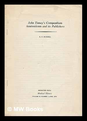
John Tinney's Compendium anatomicum and its publishers
Verlag: (Printed in Great Britain by Clunbury Cottrell Press), 1974
Offrpint. Very good paperback copy; edges somewhat slightly dust-dulled and nicked. Remains particularly well-preserved overall; tight, bright, clean and strong.; 8vo 8" - 9" tall; 174-185 pages; Physical desc.: pages run from 174-185, Notes: Reprinted from Medical history, vol. 18, no. 2, April 1974. 1 Kg.
-
911 Responding for Life : Case Studies in Emergency Care
Anbieter: Better World Books Ltd, Dunfermline, Vereinigtes Kˆnigreich
Verk‰uferbewertung 5 von 5 Sternen
Erstausgabe
EUR 24,98
EUR 5,78 Versand
Versand von Vereinigtes Kˆnigreich nach USAAnzahl: 2 verf¸gbar
In den WarenkorbZustand: Very Good. 1st Edition. Former library copy. Pages intact with possible writing/highlighting. Binding strong with minor wear. Dust jackets/supplements may not be included. Includes library markings. Stock photo provided. Product includes identifying sticker. Better World Books: Buy Books. Do Good.
-
Grover Cleveland Classic Reprint
Anbieter: PBShop.store UK, Fairford, GLOS, Vereinigtes Kˆnigreich
Verk‰uferbewertung 5 von 5 Sternen
EUR 27,50
EUR 4,81 Versand
Versand von Vereinigtes Kˆnigreich nach USAAnzahl: 15 verf¸gbar
In den WarenkorbPAP. Zustand: New. New Book. Shipped from UK. Established seller since 2000.
-

Grover Cleveland. [Public Men of To-Day, An International Series]
Verlag: Bliss, Sands & Co., London / F. Warne & Co., New York, 1896
Anbieter: G. & J. CHESTERS, TAMWORTH, Vereinigtes Kˆnigreich
Verk‰uferbewertung 5 von 5 Sternen
Erstausgabe
EUR 13,22
EUR 8,10 Versand
Versand von Vereinigtes Kˆnigreich nach USAAnzahl: 1 verf¸gbar
In den WarenkorbHardcover. Zustand: Very Good. 1st Edition. EXTREMELY RARE! pp.xvi, 240 pages, a Very Good plus hardback, publisher's original red cloth binding with gilt lettering to the spine and front cover, from a uk university.
-

Grover Cleveland
Anbieter: Ria Christie Collections, Uxbridge, Vereinigtes Kˆnigreich
Verk‰uferbewertung 5 von 5 Sternen
EUR 24,80
EUR 13,86 Versand
Versand von Vereinigtes Kˆnigreich nach USAAnzahl: Mehr als 20 verf¸gbar
In den WarenkorbZustand: New. In.
-

Digital editing and publishing in the twenty-first century
Sprache: Englisch
Verlag: Scottish Universities Press, 2025
ISBN 10: 1917341040 ISBN 13: 9781917341042
Anbieter: Ria Christie Collections, Uxbridge, Vereinigtes Kˆnigreich
Verk‰uferbewertung 5 von 5 Sternen
EUR 31,71
EUR 13,86 Versand
Versand von Vereinigtes Kˆnigreich nach USAAnzahl: Mehr als 20 verf¸gbar
In den WarenkorbZustand: New. In.
-

Grover Cleveland
Anbieter: Ria Christie Collections, Uxbridge, Vereinigtes Kˆnigreich
Verk‰uferbewertung 5 von 5 Sternen
EUR 32,86
EUR 13,86 Versand
Versand von Vereinigtes Kˆnigreich nach USAAnzahl: Mehr als 20 verf¸gbar
In den WarenkorbZustand: New. In.
-

Grover Cleveland
Anbieter: Ria Christie Collections, Uxbridge, Vereinigtes Kˆnigreich
Verk‰uferbewertung 5 von 5 Sternen
EUR 32,86
EUR 13,86 Versand
Versand von Vereinigtes Kˆnigreich nach USAAnzahl: Mehr als 20 verf¸gbar
In den WarenkorbZustand: New. In.
-

Grover Cleveland
Anbieter: Ria Christie Collections, Uxbridge, Vereinigtes Kˆnigreich
Verk‰uferbewertung 5 von 5 Sternen
EUR 34,41
EUR 13,86 Versand
Versand von Vereinigtes Kˆnigreich nach USAAnzahl: Mehr als 20 verf¸gbar
In den WarenkorbZustand: New. In.
-
Digital editing and publishing in the twenty-first century
Sprache: Englisch
Verlag: Scottish Universities Press, 2025
ISBN 10: 1917341040 ISBN 13: 9781917341042
Anbieter: Revaluation Books, Exeter, Vereinigtes Kˆnigreich
Verk‰uferbewertung 5 von 5 Sternen
EUR 43,06
EUR 14,46 Versand
Versand von Vereinigtes Kˆnigreich nach USAAnzahl: 2 verf¸gbar
In den WarenkorbPaperback. Zustand: Brand New. 448 pages. 6.14x0.91x9.21 inches. In Stock.
-

Digital editing and publishing in the twenty-first century
Sprache: Englisch
Verlag: Scottish Universities Press, 2025
ISBN 10: 1917341059 ISBN 13: 9781917341059
Anbieter: Ria Christie Collections, Uxbridge, Vereinigtes Kˆnigreich
Verk‰uferbewertung 5 von 5 Sternen
EUR 49,10
EUR 13,86 Versand
Versand von Vereinigtes Kˆnigreich nach USAAnzahl: Mehr als 20 verf¸gbar
In den WarenkorbZustand: New. In.
-
Digital editing and publishing in the twenty-first century
Sprache: Englisch
Verlag: Scottish Universities Press, 2025
ISBN 10: 1917341059 ISBN 13: 9781917341059
Anbieter: Revaluation Books, Exeter, Vereinigtes Kˆnigreich
Verk‰uferbewertung 5 von 5 Sternen
EUR 68,47
EUR 14,46 Versand
Versand von Vereinigtes Kˆnigreich nach USAAnzahl: 2 verf¸gbar
In den WarenkorbHardcover. Zustand: Brand New. 448 pages. 6.14x1.13x9.21 inches. In Stock.
-

Taschenbuch. Zustand: Neu. Grover Cleveland | James Lowry Whittle | Taschenbuch | 260 S. | Englisch | 2018 | hansebooks | EAN 9783337418748 | Verantwortliche Person f¸r die EU: Hansebooks GmbH, Trakehner Weg 52, 22844 Norderstedt, gb[at]hansebooks[dot]com | Anbieter: preigu.
-

Taschenbuch. Zustand: Neu. Grover Cleveland | James Lowry Whittle | Taschenbuch | 264 S. | Englisch | 2017 | hansebooks | EAN 9783744712156 | Verantwortliche Person f¸r die EU: Hansebooks GmbH, Trakehner Weg 52, 22844 Norderstedt, gb[at]hansebooks[dot]com | Anbieter: preigu.
-

Grover Cleveland
Sprache: Englisch
Verlag: Creative Media Partners, LLC Jul 2023, 2023
ISBN 10: 1022165119 ISBN 13: 9781022165113
Anbieter: AHA-BUCH GmbH, Einbeck, Deutschland
Verk‰uferbewertung 5 von 5 Sternen
Taschenbuch. Zustand: Neu. Neuware.
-

Grover Cleveland
Sprache: Englisch
Verlag: Creative Media Partners, LLC Jul 2023, 2023
ISBN 10: 1020922834 ISBN 13: 9781020922831
Anbieter: AHA-BUCH GmbH, Einbeck, Deutschland
Verk‰uferbewertung 5 von 5 Sternen
Buch. Zustand: Neu. Neuware - This comprehensive biography explores the life and career of Grover Cleveland, one of America's most influential presidents. The author provides a detailed analysis of Cleveland's presidency as well as a thoughtful reflection on his impact on American society in the decades that followed his death. This is a must-read for anyone interested in American history and politics.
-
A New and Elegant General Atlas
Sprache: Englisch
Verlag: Laurie and Whittle, London, 1802
Anbieter: Richard Smith, Aldershot, Vereinigtes Kˆnigreich
Verk‰uferbewertung 5 von 5 Sternen
EUR 2.680,40
EUR 34,70 Versand
Versand von Vereinigtes Kˆnigreich nach USAAnzahl: 1 verf¸gbar
In den WarenkorbHardcover. Zustand: Very Good. Laurie and Whittle's New and Elegant General Atlas; Chiefly Intended for the Use of Schools and Convenience of Gentlemen's Libraries . Containing Thirty-Eight Maps, Printed on a Fine Wove Elephant Paper. London, Printed and Published by Robert Laurie and James Whittle, Map, Chart, and Printsellers. 1802. Folio (325 x 270 mm.), engraved dedication leaf (to the Princess of Wales), title-page, index, explanation of the elementary map (No. 1) followed by 37 other fully-coloured maps numbered 2 to 38. Contemporary marbled boards (worn) skillfully rebacked and recornered in calf, with inner hinges reinforced with cloth, raised bands, red lettering-piece. A well-preserved example of this vividly-coloured atlas. A large copy with good margins. Generally in very good state, the maps clean save for occasional very minor marks or soiling in the margins, three maps (Asia, Africa and South America) with some finely-written early ms. notes, Dedication leaf with marginal waterstains. Early ownership signature (Captain Delasope[?] Bart.) on front free endpaper and title-page, later (1918) ownership name and address on ffep.
-

Commencement of the Roads to the Lakes of Lancaster, Westmoreland, as far as Hinckley & Leicester
Verlag: London, 1815
Anbieter: Clive A. Burden Ltd., Chalfont St. Giles, BUCKS, Vereinigtes Kˆnigreich
Verk‰uferbewertung 5 von 5 Sternen
Karte
EUR 29,78
EUR 25,62 Versand
Versand von Vereinigtes Kˆnigreich nach USAAnzahl: 1 verf¸gbar
In den WarenkorbNo binding. 310 x 255 mm., early outline colour, light crease lower right corner, in good condition. A road map is from Laurie and Whittle's 'New Traveller's Companion'. The firm of Laurie and Whittle relied heavily on the plates of Robert Sayer acquired following his death in 1794. Often thought of as mere publishers Robert Laurie (1755-1836) was a noted craftsman. He was a talented mezzotint engraver who invented a method of mezzotint printing in colour, an achievement that won him an award from the Royal Society of Arts in 1776. In the early 1790s he entered the publishing business with James Whittle (1757-1818) as his partner. The acquisition of Sayer's stock catapulted them into the major league. In 1806 they published a road book entitled the 'Laurie and Whittle's New Traveller's Companion' which included road maps. They were compiled by Nathaniel Coltman who working for the Post Office was perfectly placed to produce them. Engraved by J. Bye, E. Jones, B. Smith and W. West they covered territory as far as the Isle of Wight and Scotland. The format was a change from the past which up to now had largely followed the strip map format devised by John Ogilby in 1675. Coltman produces here a clear map which covers larger areas for easier reference. The map is strictly functional concentrating just on roads and distances, the earlier use of nearby features such as churches and hills is omitted. It was a success with a number of editions following and alterations were constantly made to the plates to bring them up-to-date. In 1812 Robert Laurie retired and was replaced in the partnership by his son Richard Holmes Laurie and the firm changed its name to Whittle and Laurie. Beresiner pp. 136-9; Carroll Appendix no. 16; Fordham 'Roads' p. 51.
-

Continuation of the Roads to Glasgow, and Edinburgh, as far as Abberford, and York, with Roads to Hull, (by York) and Hull, (by Lincoln) & Barton Ferry
Verlag: London, 1815
Anbieter: Clive A. Burden Ltd., Chalfont St. Giles, BUCKS, Vereinigtes Kˆnigreich
Verk‰uferbewertung 5 von 5 Sternen
Karte
EUR 35,74
EUR 25,62 Versand
Versand von Vereinigtes Kˆnigreich nach USAAnzahl: 1 verf¸gbar
In den WarenkorbNo binding. 310 x 255 mm., early outline colour, in good condition. A road map is from Laurie and Whittle's 'New Traveller's Companion'. The firm of Laurie and Whittle relied heavily on the plates of Robert Sayer acquired following his death in 1794. Often thought of as mere publishers Robert Laurie (1755-1836) was a noted craftsman. He was a talented mezzotint engraver who invented a method of mezzotint printing in colour, an achievement that won him an award from the Royal Society of Arts in 1776. In the early 1790s he entered the publishing business with James Whittle (1757-1818) as his partner. The acquisition of Sayer's stock catapulted them into the major league. In 1806 they published a road book entitled the 'Laurie and Whittle's New Traveller's Companion' which included road maps. They were compiled by Nathaniel Coltman who working for the Post Office was perfectly placed to produce them. Engraved by J. Bye, E. Jones, B. Smith and W. West they covered territory as far as the Isle of Wight and Scotland. The format was a change from the past which up to now had largely followed the strip map format devised by John Ogilby in 1675. Coltman produces here a clear map which covers larger areas for easier reference. The map is strictly functional concentrating just on roads and distances, the earlier use of nearby features such as churches and hills is omitted. It was a success with a number of editions following and alterations were constantly made to the plates to bring them up-to-date. In 1812 Robert Laurie retired and was replaced in the partnership by his son Richard Holmes Laurie and the firm changed its name to Whittle and Laurie. Beresiner pp. 136-9; Carroll Appendix no. 16; Fordham 'Roads' p. 51.
-

"A New Map of the Seat of War Comprehending Germany, Poland, with its dismemberments, Prussia, Turkey in Europe, Italy &c" - Deutsches Reich Polska Polen Poland Italia Croatia Germany Hungary Austria
Sprache: Englisch
Verlag: London 18087., 1808
Anbieter: Antiquariat Steffen Vˆlkel GmbH, Seubersdorf, Deutschland
Verk‰uferbewertung 5 von 5 Sternen
Karte
Original altkolorierte Kupferstich-Karte von 1807. -- Blatt-Maþe: ca. 76 x 82 cm. -- im Mittelbug mit teils hinterlegten Einrissen, mit leichtem Abklatsch, sonst gut erhalten. || Original old colored copper engraved map from 1807. Rare map printed from 2 plates. -- minor offsetting, with tears in the folds, partially backed, otherwise in very good condition. || Dies ist ein Original! - Kein Nachdruck! - Keine Kopie! -- This is an original! No copy! - No reprint! // Wir, das Antiquariat Steffen Vˆlkel, kaufen und verkaufen alte B¸cher, Handschriften, Zeichnungen, Autographen, Grafiken und Fotografien. Wir sind stets am Ankauf von kompletten Bibliotheken, Sammlungen und Nachl‰ssen interessiert. Sprache: Englisch.
-
Vatican Decrees, Etc. (8 Texts in Two Volumes: The Vatican Decrees; Vaticanism; A Letter Addressed to his Grace The Duke of Norfolk; Speeches of Pope Pius IX; Italy and her Church; The Church's Creed or the Crown's Creed?; The Roman Index and its Late Proceedings; Freedom of Education) (2 Volume Set)
Verlag: John Murray / Longmans, Green, and co / J. T. Hayes / Hodges, Smith and Co, 1875
Anbieter: St Philip's Books, P.B.F.A., B.A., Oxford, Vereinigtes Kˆnigreich
Verbandsmitglied: PBFA
Verk‰uferbewertung 5 von 5 Sternen
EUR 208,48
EUR 15,04 Versand
Versand von Vereinigtes Kˆnigreich nach USAAnzahl: 1 verf¸gbar
In den WarenkorbBinding sound, text unmarked. Zustand: Very Good+. Zustand des Schutzumschlags: No dustwrapper as issued. Heavy tan calf, raised bands and gilt decoration to spine, red gilt spine labels, and marbled boards. A collection of Victorian sources: 1. The Vatican Decrees in their Bearing on Civil Allegiance: A Political Expostulation by Gladstone (John Murray, 1874); 2. A Series of Glued-in Newspaper Clippings from The Times Addressed to Gladstone; 3. Vaticanism: An Answer to Replies and Reproofs by Gladstone (John Murray, 1875); 4. The Vatican Decrees in their Bearing on Civil Allegiance by Henry Edward, Archbishop of Westminster (Longmans, Green, and Co., 1875); 5. A Letter Addressed to His Grace The Duke of Norfolk on Occasion of Mr. Gladstone's Recent Expostulation by John Henry Newman (B. M. Pickering, 1875); 6. Clipping from the Speeches of Pope Pius IX; 7. Italy and her Church (Church Quarterly Review No.1, 1875); 7. The Church's Creed or the Crown's Creed?: A Letter to The Most Rev. Archbishop Manning by Edmund S. Ffoulkes (J. T. Hayes, 1868?); 8. The Roman Index and its Late Proceedings: A Second Letter to the Most Rev. Archbishop Manning by Edmund S. Ffoulkes (J. T. Hayes, 1869); 9. Freedom of Education: What it Means by James Lowry Whittle (Hodges, Smith and Co., 1866). Robust packaging. Tracking is always added to USA orders. It can be added to other overseas orders on request. Used books are exempt from USA tariffs. Bookplate of Cranmore House Library. Size: 72, 128, vii, 193, 131 + 266-304, 35, 66, 71, 71pp. Bookplate of Cranmore House Library.
-
Laurie and Whittle's New and Improved English Atlas, divided into Counties
Verlag: Robert Laurie and James Whittle, No. 53, Fleet-Street, London, 1807
Anbieter: Clive A. Burden Ltd., Chalfont St. Giles, BUCKS, Vereinigtes Kˆnigreich
Verk‰uferbewertung 5 von 5 Sternen
EUR 1.185,33
EUR 25,62 Versand
Versand von Vereinigtes Kˆnigreich nach USAAnzahl: 1 verf¸gbar
In den WarenkorbNo binding. Oblong quarto (230 x 295 mm.), later half red calf to style, preserving original paper boards with ornate printed panels, spine with gilt ruled compartments, each with central gilt floral design, gilt title. With finely engraved frontispiece title, typographic title, Advertisement, Contents, engraved Explanation in early colour and 48 engraved maps (West Riding in 2 sheets) all in fine early outline colour with wash borders, each accompanied by a leaf of descriptive text, some surface dirt to first general map, South Wales with light paper folds, otherwise in good condition. The majority of the plates for this atlas were first issued in the 'Universal Magazine' from 1791 to 1798 and are engraved by Benjamin Baker (1766-1841) who was particularly active through 1824 as an engraver for the Ordnance Survey. These early Surveys are highly prized for their detail. The publisher of the 'Universal Magazine' was William Bent. In 1804, the plates appeared in a rare atlas entitled 'Maps of the Several Counties and Shires in England' by William Darton (1755-1819) and Joseph Harvey (1764-1841). Then they were acquired by the firm of Laurie and Whittle. Often thought of as mere publishers, Robert Laurie (1755-1836) was a noted craftsman. He was a talented mezzotint engraver who invented a method of mezzotint printing in colour, an achievement that won him an award from the Royal Society of Arts in 1776. In the early 1790s he entered the publishing business with James Whittle (1757-1818) as his partner. The acquisition of Sayer's stock catapulted them into the major league. In 1806, they published a road book entitled 'Laurie and Whittle's New Traveller's Companion' which included road maps. It was originally thought that in the following year this work was published having just acquired the Baker plates of the English counties. The two were clearly meant to complement each other in their stock. Then in 2003 an example dated 1806 on the title page appeared at auction. It remains the only example traced. Three further maps were supplied including the general map dated 1801 by Laurie and Whittle, an apparently new plate of the Isle of Wight engraved by Baker dated 1806 and a general map of Yorkshire to complement those of the Ridings also dated 1806.The descriptions include a wealth of information including the population data gathered by the Government in 1801. An interesting note on the Explanation states 'The connection of the Turnpike Roads from one County to another, are shown by Reference Letters'. This feature was of course first introduced by John Cary in 1793. Provenance: Donald Hodson collection (1933-2016), carto-bibliographer. Beresiner (1983) p. 50; Carroll (1996) 53; Chubb (1927) 294; Worms & Baynton-Williams (2011).
-
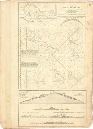
The Cape Verd Islands, laid down from the Remarks and Observations of Experienced Navigators, by Monsr. d'Apres de Mannevillete, with several Additions.
Verlag: LondonLaurie & Whittle 12th May ., 1794
Anbieter: Robert Frew Ltd. ABA ILAB, London, Vereinigtes Kˆnigreich
Verbandsmitglied: ABA ILAB PBFA
Verk‰uferbewertung 5 von 5 Sternen
Karte
EUR 178,69
EUR 11,57 Versand
Versand von Vereinigtes Kˆnigreich nach USAAnzahl: 1 verf¸gbar
In den WarenkorbOriginal uncoloured engraved map of the Cape Verde islands. Map dimensions 52 x 28.5 cm, overall sheet dimensions 54 x 38.5 cm. A bit toned overall and with some smudging to marings. A finely detailed chart of the Cape Verde Islands off the Coast of Africa, which appeared in a later edition of the West India Atlas. This sheet of sea charts details the Cape Verde Islands. First settled by the Portuguese in 1462, it soon became a popular haunt for pirates, including Sir Francis Drake in the 1580s. The sheet features with inset maps of Praya Bay, A View of the English Road, A View of Praya Bay and a group of recognition views. Sayer and Bennet based their work on charts by Jean-Baptiste Mannevillettes's Le Neptune Oriental (Paris, 1745).
-

Chart of the West Coast of Sumatra from Bencoolen to Keysers Bay
Verlag: Laurie & Whittle, London, 1786
Anbieter: Clive A. Burden Ltd., Chalfont St. Giles, BUCKS, Vereinigtes Kˆnigreich
Verk‰uferbewertung 5 von 5 Sternen
Karte
EUR 208,48
EUR 25,62 Versand
Versand von Vereinigtes Kˆnigreich nach USAAnzahl: 1 verf¸gbar
In den WarenkorbNo binding. Zustand: Very Good. 640 x 930 mm., in recent wash colour, with very wide margins, in good condition. This chart is found in examples of Laurie and Whittle's "Complete East India Pilot". It shows the extreme south western shore of Sumatra leading to the Straits of Sunda. Inset plans of Cawoor Bay, Pulo Pisang and Little Fortune Island with Billimbing Bay are all by Captain Joseph Huddart. Joseph Huddart (1741-1816) was a Captain in the East India Company as a hydrographer and civil engineer. This chart was one of many of his work which are found in Laurie and Whittle's "Complete East India Pilot" which was first published in 1798. NMM 379 no. 146.
-

Sketch of the Straits of Gaspar by J. Huddart
Verlag: Laurie & Whittle, 12th May, 1794., London,, 1794
Anbieter: Daniel Crouch Rare Books Ltd, London, Vereinigtes Kˆnigreich
Verbandsmitglied: ABA ILAB PBFA
Verk‰uferbewertung 4 von 5 Sternen

Karte
EUR 214,43
EUR 23,13 Versand
Versand von Vereinigtes Kˆnigreich nach USAAnzahl: 1 verf¸gbar
In den WarenkorbGaspar Strait Engraved chart on two sheets, joined. Chart of the navigational channel between the islands of Bangka and Belitung in the Java Sea. Showing the tracks of several English vessels from the 1780s. From an early edition of Laurie & Whittle's rare 'East India Pilot', and one of the first charts published after their purchase of Robert's Sayer's business. Laurie & Whittle's 'East India Pilot' was published as a practical guide to navigators aboard ships of the Royal Navy and East Indiamen, and often taken to sea, and this chart appears to be no exception. All variants of Laurie and Whittle's 'Oriental' pilots of eastern waters are scarce, and were published under several titles, each with a different complement of charts. Variants include: 'The Country Trade East-India Pilot, for the Navigation of the East-Indies and Oriental Seas, within the limits of the East-India Company', 'The Complete East-India Pilot, or Oriental Navigator', 'The East-India Pilot, or Oriental Navigator', and 'The Oriental Pilot; Or, East-India Directory' focusing on the most important charts used for the journey. The foundation of the partnership of Robert Laurie (17551836) and James Whittle (17571818) was the existing stock of Robert Sayer's printing plates, both for maps and atlases and also decorative prints. Laurie had originally apprenticed to Robert Sayer in 1770, and made free in 1777. He was a skilled artist, who exhibited at the Society of Artists from 1770, winning a silver palette for a drawing in 1770, and he was also an accomplished engraver of mezzotint portraits and produced views and other decorative items. In about 1792 he returned to the Sayer business and took it over from the ailing Sayer in 1794. Whittle was apprenticed into the Needlemakers' Company, evidently made free by 1792, and joined with Laurie to take over the Sayer business in 1794. Laurie retired in 1812. His son Richard Holmes Laurie replaced him in the partnership and, eventually, took over the firm after Whittle's death in 1818. Presumably under the influence of Richard Holmes Laurie, the partnership became noted as chartmakers and publishers, with the business existing to the current day as Imray, Laurie, Norie and Wilson. Provenance: Early annotations in pencil recording the true position of Gaspar Island, Middle Island, and one or two unrecorded shoals.
-

The Russian Dominions in Europe
Verlag: London, 1820
Anbieter: Clive A. Burden Ltd., Chalfont St. Giles, BUCKS, Vereinigtes Kˆnigreich
Verk‰uferbewertung 5 von 5 Sternen
Karte
EUR 268,04
EUR 25,62 Versand
Versand von Vereinigtes Kˆnigreich nach USAAnzahl: 1 verf¸gbar
In den WarenkorbNo binding. 785 x 610 mm., in fine early wash colour. Good paper in fine condition. A nice attractive large scaled map of European Russia.


