Thomas kitchen (22 Ergebnisse)

Sprache: Englisch
Verlag: The Dr. Gertrude A. Barber National Institute, 2007
- Softcover
Anbieter: World of Books (was SecondSale), Montgomery, IL, USAWorld of Books (was SecondSale)
Verkäufer/-in kontaktierenVerkäufer/-in mit 5 SternenZustand: Gebraucht - Befriedigend
EUR 4,81
Versand nach gratisVersand innerhalb von USAAnzahl: 1 verfügbar
Zustand: Good. Item in good condition. Textbooks may not include supplemental items i.e. CDs, access codes etc.
Sprache: Englisch
Verlag: The Dr. Gertrude A. Barber National Institute, 2007
- Softcover
Anbieter: World of Books (was SecondSale), Montgomery, IL, USAWorld of Books (was SecondSale)
Verkäufer/-in kontaktierenVerkäufer/-in mit 5 SternenZustand: Gebraucht - Gut
EUR 4,81
Versand nach gratisVersand innerhalb von USAAnzahl: 1 verfügbar
Zustand: Very Good. Item in very good condition! Textbooks may not include supplemental items i.e. CDs, access codes etc.

- Softcover
Anbieter: PBShop.store UK, Fairford, GLOS, Vereinigtes KönigreichPBShop.store UK
Verkäufer/-in kontaktierenVerkäufer/-in mit 5 SternenZustand: Neu
EUR 18,75
EUR 4,88 VersandVersand von Vereinigtes Königreich nach USAAnzahl: Mehr als 20 verfügbar
PAP. Zustand: New. New Book. Shipped from UK. Established seller since 2000.

- Hardcover
Anbieter: PBShop.store UK, Fairford, GLOS, Vereinigtes KönigreichPBShop.store UK
Verkäufer/-in kontaktierenVerkäufer/-in mit 5 SternenZustand: Neu
EUR 26,85
EUR 4,88 VersandVersand von Vereinigtes Königreich nach USAAnzahl: Mehr als 20 verfügbar
HRD. Zustand: New. New Book. Shipped from UK. Established seller since 2000.

- Softcover
Anbieter: Ria Christie Collections, Uxbridge, Vereinigtes KönigreichRia Christie Collections
Verkäufer/-in kontaktierenVerkäufer/-in mit 5 SternenZustand: Neu
EUR 27,34
EUR 14,07 VersandVersand von Vereinigtes Königreich nach USAAnzahl: Mehr als 20 verfügbar
Zustand: New. In.

- Hardcover
Anbieter: Ria Christie Collections, Uxbridge, Vereinigtes KönigreichRia Christie Collections
Verkäufer/-in kontaktierenVerkäufer/-in mit 5 SternenZustand: Neu
EUR 36,01
EUR 14,07 VersandVersand von Vereinigtes Königreich nach USAAnzahl: Mehr als 20 verfügbar
Zustand: New. In.

- Hardcover
Anbieter: Revaluation Books, Exeter, Vereinigtes KönigreichRevaluation Books
Verkäufer/-in kontaktierenVerkäufer/-in mit 5 SternenZustand: Neu
EUR 439,75
EUR 29,35 VersandVersand von Vereinigtes Königreich nach USAAnzahl: 1 verfügbar
Hardcover. Zustand: Brand New. 2nd ed. 2020 edition. 1556 pages. 9.25x6.10x1.50 inches. In Stock.
Verlag: P.S. 1 / Institute for Art and Urban Resources Long Island City, NY, 1981
- Softcover
Anbieter: Specific Object / David Platzker, New York, NY, USASpecific Object / David Platzker
Verkäufer/-in kontaktierenVerkäufer/-in mit 5 SternenZustand: Gebraucht
EUR 135,34
EUR 7,45 VersandVersand innerhalb von USAAnzahl: 1 verfügbar
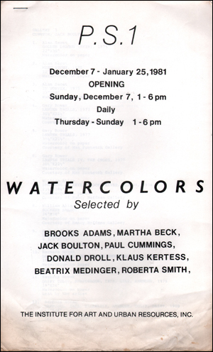
[18] pp.; 35.5 x 21.6 cm.; staple bound; black-and-white; edition size unknown; unsigned and unnumbered; offset-printed Exhibition checklist published in conjunction with show held December 7 - January 25, 1981. Watercolors selected by Brooks Adams, Martha Beck, Jack Boulton, Paul Cummings, Donald Droll, Klaus Kertess, Beatrix M…edinger and Roberta Smith. Artists included Alan Saret, Gary Bower, William Allan, Mimmo Paladino, Barbara Novak, Richard Tuttle, Robin Bruch, Stephen Mueller, Michael Tetherow, Robert Kushner, George Sugarman, Judy Pfaff, Carroll Dunham, Stephen Ellis, Nancy Mitchnick, John Torreano, Nancy Spero, Judith Linhares, Wes Disney, Ellen Phelan, Lucio Pozzi, Edith Gauthmey, Frank Moore, Gioia Timpanelli, Sondra Freckelton, Saul Steinberg, Jack Youngerman, Robert Kitchen, William Garbe and Thomas Lo Cicero. Fair. Significant wear to bottom edges of publication including yellowing, soiling and bumping. 4 mm. tear to right side recto edge. 4 mm. tear to left side edge of verso. 7 mm. dog-ear to upper right corner of recto and 1.2 cm. dog-ear to bottom left corner of recto. 3.3 cm. of yellow to bottom edge of verso, continuing through to interior pages. Additional handling wear and rubbing.
Verlag: Arthus-Bertrand, 1806
- Hardcover
- Erstausgabe
Anbieter: Arroyo Seco Books, Pasadena, Member IOBA, Pasadena, CA, USAArroyo Seco Books, Pasadena, Member IOBA
Verkäufer/-in kontaktierenVerkäufer/-in mit 4 SternenVerbandsmitglied: IOBA
Zustand: Gebraucht - Befriedigend
EUR 225,57
EUR 7,01 VersandVersand innerhalb von USAAnzahl: 1 verfügbar
Hardcover. Zustand: Good. 1st Edition. 511 Pp. + two pages of corrections at end, also a 14 3/8" x 17 5/8" map "Carte D'une Partie de la Grece, avec le Peloponnese, ou la Moree, corrigee et amelioree d'apres les Authorites les plus recentes" bound in at end. Volume III (only), beginning with Chapter XXIII (in Athens). A translat…ion with new notes, etc., in French, of course. Original binding, some wear, solid, leather worn through at tips, spine gilt still bright, contents and endpapers fine, map fine with a short tear along spine outside margin of map, one 1/4" foxing spot , small remains of a paper label at bottom of spine. [den]. Large Map of Greece By Kitchen, in French (illustrator).

Verlag: London, 1776
- Karte
Anbieter: Alexandre Antique Prints, Maps & Books, Toronto, ON, KanadaAlexandre Antique Prints, Maps & Books
Verkäufer/-in kontaktierenVerkäufer/-in mit 4 SternenZustand: Gebraucht
EUR 112,78
EUR 5,26 VersandVersand von Kanada nach USAAnzahl: 1 verfügbar
Zustand: Excellent. Size : 254x180 (mm), 10x7.125 (Inches), Hand Colored.
Verlag: LondonR. & J. Dodsley, 1761
- Karte
Anbieter: Robert Frew Ltd. ABA ILAB, London, Vereinigtes KönigreichRobert Frew Ltd. ABA ILAB
Verkäufer/-in kontaktierenVerkäufer/-in mit 5 SternenZustand: Gebraucht
EUR 302,32
EUR 11,74 VersandVersand von Vereinigtes Königreich nach USAAnzahl: 1 verfügbar
Original engraved map with outline hand colour (47 x 53 cm; overall 58 x 60 cm).

Verlag: Artist: Kitchin (Kitchen) Thomas ( - 1784 ) London ca : 1740, 1718
Anbieter: Antique Sommer& Sapunaru KG, München, DeutschlandAntique Sommer& Sapunaru KG
Verkäufer/-in kontaktierenVerkäufer/-in mit 4 SternenZustand: Gebraucht
EUR 280,00
EUR 45,00 VersandVersand von Deutschland nach USAAnzahl: 1 verfügbar
Technic: Copper print, colorit: original colored, condition: Very good, size (in cm): 17,5 x 24 cm, Map shows total Franconia with Wuerzburg, Bamberg, Kulmbach, Ansbach, Nuremberg and Aichstaett.

Verlag: Artist: Robertson/ Kitchen G/Thomas ( - 1793 ) ca : 1777, 1721
Anbieter: Antique Sommer& Sapunaru KG, München, DeutschlandAntique Sommer& Sapunaru KG
Verkäufer/-in kontaktierenVerkäufer/-in mit 4 SternenZustand: Gebraucht
EUR 280,00
EUR 45,00 VersandVersand von Deutschland nach USAAnzahl: 1 verfügbar
Technic: Copper print, colorit: colored, condition: Right Margin enlarged, size (in cm): 44 x 32,5 cm, Map shows total South America, with detailed depiction and representation of all countries, rivers, mountains, lakes and a title cartouche.

Verlag: London, 1770
- Karte
Anbieter: Alexandre Antique Prints, Maps & Books, Toronto, ON, KanadaAlexandre Antique Prints, Maps & Books
Verkäufer/-in kontaktierenVerkäufer/-in mit 4 SternenZustand: Gebraucht - Gut
EUR 338,35
EUR 5,26 VersandVersand von Kanada nach USAAnzahl: 1 verfügbar
Zustand: Very Good. Handsome map of Great Britain with decorative cartouche., Size : 375x340 (mm), 14.76x13.39 (Inches), Hand Colored in Outline.

Verlag: Prinald, London, 1750
- Karte
Anbieter: Alexandre Antique Prints, Maps & Books, Toronto, ON, KanadaAlexandre Antique Prints, Maps & Books
Verkäufer/-in kontaktierenVerkäufer/-in mit 4 SternenZustand: Gebraucht
EUR 338,35
EUR 5,26 VersandVersand von Kanada nach USAAnzahl: 1 verfügbar
Zustand: Excellent. Size : 200x295 (mm), 7.875x11.625 (Inches), Hand Colored in Outline.

Verlag: Artist: Kitchin (Kitchen) Thomas ( - 1784 ) London ca : 1770, 1718
Anbieter: Antique Sommer& Sapunaru KG, München, DeutschlandAntique Sommer& Sapunaru KG
Verkäufer/-in kontaktierenVerkäufer/-in mit 4 SternenZustand: Gebraucht
EUR 350,00
EUR 45,00 VersandVersand von Deutschland nach USAAnzahl: 1 verfügbar
Technic: Copper print, colorit: colored, condition: Perfect condition, size (in cm): 22,5 x 27 cm, Map shows Hungary, Transilvania, Slavonia, Bosnia, Croatia, Dalmatia and a titelcartouche.

Verlag: Artist: Kitchin (Kitchen) Thomas ( - 1784 ) London ca : 1775, 1718
Anbieter: Antique Sommer& Sapunaru KG, München, DeutschlandAntique Sommer& Sapunaru KG
Verkäufer/-in kontaktierenVerkäufer/-in mit 4 SternenZustand: Gebraucht
EUR 350,00
EUR 45,00 VersandVersand von Deutschland nach USAAnzahl: 1 verfügbar
Technic: Copper print, colorit: colored, condition: Perfect condition, size (in cm): 42 x 56 cm, Map shows the whole of Germany with Austria, Pomerania, Silesia, the Czech Republic and the Benelux countries.

Verlag: Artist: Kitchin (Kitchen) Thomas ( - 1784 ) London ca : 1760, 1718
Anbieter: Antique Sommer& Sapunaru KG, München, DeutschlandAntique Sommer& Sapunaru KG
Verkäufer/-in kontaktierenVerkäufer/-in mit 4 SternenZustand: Gebraucht
EUR 410,00
EUR 45,00 VersandVersand von Deutschland nach USAAnzahl: 1 verfügbar
Technic: Copper print, colorit: colored, condition: Some folds, size (in cm): 33,5 x 38, Map depicts Africa with Madagascar, a winrose in the cartouche.

Verlag: Artist: Kitchin (Kitchen) Thomas ( - 1784 ) London dated : 1777, 1718
Anbieter: Antique Sommer& Sapunaru KG, München, DeutschlandAntique Sommer& Sapunaru KG
Verkäufer/-in kontaktierenVerkäufer/-in mit 4 SternenZustand: Gebraucht
EUR 500,00
EUR 45,00 VersandVersand von Deutschland nach USAAnzahl: 1 verfügbar
Technic: Copper print, colorit: colored, condition: Very good, size (in cm): 31 x 47, map of the Caribbean Islands.

Verlag: Artist: Kitchin (Kitchen) Thomas ( - 1784 ) London ca : 1782, 1718
Anbieter: Antique Sommer& Sapunaru KG, München, DeutschlandAntique Sommer& Sapunaru KG
Verkäufer/-in kontaktierenVerkäufer/-in mit 4 SternenZustand: Gebraucht
EUR 530,00
EUR 45,00 VersandVersand von Deutschland nach USAAnzahl: 1 verfügbar
Technic: Copper print, colorit: colored, condition: Some folds, size (in cm): 34 x 38, Map depicts South Amrica, the islands of Galapagos with a decorative cartouche. From Millar's New Complete Universal System of Geography.

Verlag: Sayer, Robert, London, 1787
Anbieter: Argosy Book Store, ABAA, ILAB, New York, NY, USAArgosy Book Store, ABAA, ILAB
Verkäufer/-in kontaktierenVerkäufer/-in mit 5 SternenZustand: Gebraucht
EUR 857,15
EUR 5,26 VersandVersand innerhalb von USAAnzahl: 1 verfügbar
unbound. Map, in two sheets. Copper plate engraving with original outline hand color. Each image measures 28" x 45". This large-scale wall map depicts the entirety of England and Wales extending to parts of Ireland, Scotland, and France. Map has an incredibly fancy commodities cartouche including depictions of cannons, clocks, s…heep, the military, representing everything that England was doing at the time. This map was made right around the time the concept of longitude was discovered. perhaps why the clock and time is represented in the cartouche. Based on the work of Marcus Armstrong, this two-part map has a particular focus on military and post roads. Hand-colored lines divide and subdivide shires, mountains are depicted pictorially, and bodies of water such as lochs and firths are all labeled. At the upper right is a large inset of the "The Islands of Shetland or Zetland." The upper left corner contains a decorative title cartouche, and the map's lower left contains a key of "Distances of the Principal Stages on the Great Roads Leading from Edinburgh." The map is in good condition with little edge wear. Minor foxing and offsetting throughout. Robert Sayer (1725-1794) was an important English publisher of maps, portraits, and nautical engravings. Partnering with John Bennett around the 1760s, the two published the works of well-known cartographers such as Kitchen, Jefferys, Belling, d'Anville and others. This beautiful, large-scale map is an impressive example of his work.

Verlag: Paris, 1755
- Karte
Anbieter: Alexandre Antique Prints, Maps & Books, Toronto, ON, KanadaAlexandre Antique Prints, Maps & Books
Verkäufer/-in kontaktierenVerkäufer/-in mit 4 SternenZustand: Gebraucht - Gut
EUR 789,48
EUR 5,26 VersandVersand von Kanada nach USAAnzahl: 1 verfügbar
Zustand: Very Good. Size : 475x540 (mm), 18.75x21.25 (Inches), Hand Colored.


