Gesamtpreis (1 Artikel Artikel):
Versandziel:

thevenot melchisedec (7 Ergebnisse)
Direkt zu den wichtigsten Suchergebnissen
Suchfilter
Produktart
- Alle Product Types
- Bücher (6)
- Magazine & Zeitschriften (Keine weiteren Ergebnisse entsprechen dieser Verfeinerung)
- Comics (Keine weiteren Ergebnisse entsprechen dieser Verfeinerung)
- Noten (Keine weiteren Ergebnisse entsprechen dieser Verfeinerung)
- Kunst, Grafik & Poster (Keine weiteren Ergebnisse entsprechen dieser Verfeinerung)
- Fotografien (Keine weiteren Ergebnisse entsprechen dieser Verfeinerung)
- Karten (1)
- Manuskripte & Papierantiquitäten (Keine weiteren Ergebnisse entsprechen dieser Verfeinerung)
Zustand Mehr dazu
- Neu (Keine weiteren Ergebnisse entsprechen dieser Verfeinerung)
- Wie Neu, Sehr Gut oder Gut Bis Sehr Gut (1)
- Gut oder Befriedigend (Keine weiteren Ergebnisse entsprechen dieser Verfeinerung)
- Ausreichend oder Schlecht (Keine weiteren Ergebnisse entsprechen dieser Verfeinerung)
- Wie beschrieben (6)
Einband
- alle Einbände
- Hardcover (2)
- Softcover (Keine weiteren Ergebnisse entsprechen dieser Verfeinerung)
Weitere Eigenschaften
- Erstausgabe (2)
- Signiert (Keine weiteren Ergebnisse entsprechen dieser Verfeinerung)
- Schutzumschlag (1)
- Angebotsfoto (5)
Sprache (1)
Preis
- Beliebiger Preis
- Weniger als EUR 20 (Keine weiteren Ergebnisse entsprechen dieser Verfeinerung)
- EUR 20 bis EUR 45 (Keine weiteren Ergebnisse entsprechen dieser Verfeinerung)
- Mehr als EUR 45
Gratisversand
- Kostenloser Versand nach USA (Keine weiteren Ergebnisse entsprechen dieser Verfeinerung)
Land des Verkäufers
Verkäuferbewertung
-
![Bild des Verkäufers für Foundation Stones. [Our Literary Heritage; Earliest References; Early Settlement; The Theologians; Publications Preceding the Revolution; Science; Prose; Poetry and Drama; The Beginning of Government] zum Verkauf von Joseph Valles - Books](https://pictures.abebooks.com/inventory/md/md943115908.jpg)
Foundation Stones. [Our Literary Heritage; Earliest References; Early Settlement; The Theologians; Publications Preceding the Revolution; Science; Prose; Poetry and Drama; The Beginning of Government]
Verlag: New York : Privately Printed, [The Printing Office of Yale University Press], 1952, 1952
Anbieter: Joseph Valles - Books, Stockbridge, GA, USA
Verkäuferbewertung 5 von 5 Sternen

Hardcover. Zustand: Fine. Zustand des Schutzumschlags: Fine. 179 pp. ; portrait, maps (partly folded) facsimiles ; 26 cm ; LCCN: 53-17102 ; OCLC: 1956309 ; LC: Z1207; Dewey: 016.973 ; "Seven hundred copies printed" ; marbled paper on red cloth, in silvered brown paper-covered slipcase ; numerous foldouts with facsimiles of important documents and published sources of American history, including Letter by Christopher Columbus, Virginia RIchly Valued, Description of Louisiana, A Brief Relation of North Virginia, The Seaman's Grammar, Bay Psalm Book, Plain Truth, etc, etc ; FINE/FINE. Book.
-
Relations de divers voyages curieux,
Anbieter: Douglas Stewart Fine Books, Armadale, VIC, Australien
Verkäuferbewertung 4 von 5 Sternen

Erstausgabe
EUR 39.635,40
EUR 31,80 Versand
Versand von Australien nach USAAnzahl: 1 verfügbar
In den Warenkorbqui n'ont point esté publiees, ou qui ont esté traduites d'Hacluyt, de Purchas, & d'autresVoyageurs Anglois, Hollandois, Portugais, Allemands, Espagnols; et de quelques Persans, Arabes & autres Orientaux.Enrichies de Figures de Plantes non décrites, d'Animaux inconnus ŕ l'Europe, et de Cartes Geographiques de Paysdont on n'a point encore donné de Cartes. Paris : Jacques Langlois, 1663-1664 [Sebastien Mabre-Cramoisy, 1666] [André Cramoisy, 1672]. Four parts in two volumes, folio, matching contemporary bindings of mottled calf, spines with raised bands tooled and lettered in gilt; marbled pastedowns and endpapers; Part 1. title-leaf in red and black, pp. [12], xxv, 1-52, 1-24, 17-26, 17-29, 26-31, 36-40, 1-12, 1-80, 1-30, 1-10, 19-24, 1-36, 1-56, with 4 folding maps (3 double-page), 2 folding double-page plates, 3 full-page plates and numerous smaller plates in the text. Part 2. title-leaf, pp. [9], 1-20, 1-60, 1-128, 1-40, 1-16, 1-44, 47-48, 1-4, 1-30, with 8 folding double-page plates (including 5 coastal profiles), 3 full-page plates, 3 smaller plates in the text, 1 folding map. Part 3. title-leaf, pp. [12], 31-68, 1-12, 1-28, 1-216 (frequent misnumbering), with 11 plates (3 double-page), 2 folding double-page maps. Part 4. title-leaf, pp. [2], 1-24, 1-14, 1-[24], 1-23, [blank], 1-24, 1-16, 1-16, 1-8, 1-4, [2], 1-45, [blank], 47-58, 1-40, with 2 small plates in the text, 46 woodcuts, and 2 folding maps. The first edition of each of the first four parts of Thévenot?s monumental work. Amongst travel collections of the seventeenth-century, Thévenot?s occupies a distinguished place, being one of the most complete and lavishly produced. Its scope includes Africa, the Far East, Southeast Asia, the Americas, Australia and other regions.The narrative of Abel Tasman on Australia is certainly one of the most significant and primary sources of information on the island continent. The collection is also of great American interest, containing Palafox?s study on the natives, Acarette du Biscay?s relation of La Plata and Gage?s narrative, which includes an important passage on Mexico, and is profusely illustrated with full-page woodcuts. Asia and Africa are also well represented, with over half of the first volume being dedicated to these regions. The work is illustrated with maps and views. The maps include the famous Tasman map of Australia (Hollandia Nova) in its fifth state (with rhumb lines and the Tropic of Capricorn, and '19' added at top right). The importance of this map can hardly be overstated: it is a cornerstone of Australian cartography, both as the earliest obtainable map of the region as well as the predominant depiction by which the West would know the island for about a century. Amongst the numerous other maps are one of Japan and Pegu (usually lacking) and charts of the Indies, China, Hindustan, and East Africa; the plates include depictions of costumes, plants, and architecture. Thévenot?s work is an exceedingly difficult book to collate: ?Bibliographers have expended great pains on the collation of the Thévenot collection? (Catalogue of the John Carter Brown Library, vol. III, 102); ?Collection interessante, dont il est difficile de trouver des exemplaires complets? (Brunet). Thévenot?s collection was published in parts and over roughly 10 years, thus there are virtually no two copies alike. The first part went to the printer in 1663, the second and third in [1664 and] 1666 and the fourth in 1672; a fifth part was being prepared at the time of Thévenot's death, leaving the work uncompleted. Sabin?s note is very enlightening regarding this issue: ?It will be understood from this that there really was only one edition of Thévenot, and as that edition was completed only in 1696, the issue bearing that year on its general title-page is ordinarily regarded as the standard for collation.? (JCBL) Brunet, Manuel du Libraire et de L? Amateur de Livres, V, pp. 810-13; Palau, 331563.
-

Relations de Divers Voyages Curieux qui n'ont point esté publiées, ou qui ont esté traduites d'Hacluyt, de Purchas et d'autres voyages Anglais, Hollandais, Portugais, Allemands, Espagnols, et de quelques Persans, Arabes et auteurs orientaux.
Verlag: Jacques Langlois, chez G. Meturas, S. Piget, E. Langlois, T. Joly & L. Billaine
Anbieter: Daniel Crouch Rare Books Ltd, London, Vereinigtes Königreich
Verbandsmitglied: ABA ILAB PBFA
Verkäuferbewertung 4 von 5 Sternen
EUR 41.701,26
EUR 23,14 Versand
Versand von Vereinigtes Königreich nach USAAnzahl: 1 verfügbar
In den WarenkorbThevenot's Voyages First edition, first part only, Folio (360 by 230mm). (4)ff, XXVpp., 52pp., 50pp. (poorly numbered, but complete), 12pp., 80pp., 30pp., 19p. (poorly numbered, but complete), 35pp., 56pp (poorly numbered, but complete), 9pp., (2)pp., numerous pages misnumbered, but complete, four engraved plates (two double-page), four illustrations in the text, and four engraved maps,; contemporary mottled calf, rebacked, spine in 7 compartments with red morocco lettering piece, gilt, in the second. A rare first edition, of the first part of the first volume, with the map of Australia in the first state: one of the earliest printed maps of the country. The first three volumes were published between 1663 and 1666. A fourth part was published in 1672, and a fifth part unfinished in 1696. "It is difficult to find complete copies" Brunet (V, 810-813), because each volume is composed of separate parts. Brunet adds that "no two examples have the same parts in the same order". The text is based on the original manuscripts collected by Melchisedec Thevenot, Orientalist and librarian to the King, and offers much good information on the Dutch East India Company (V.O.C.), Eastern alphabets, one of the first representations of cuneiform characters, etc. The mapmakers Abel Jansz. Tasman (c1603-1659), was the first European explorer to reach and map the coastlines of Tasmania and New Zealand. After a series of shipwrecks had revealed some of the western coast of Australia, he was chosen by Anthony van Diemen, governor-general of the Dutch East Indies, to lead a voyage of discovery to the south, in 1642. The intention was to find a sea route south of Nuyts land, and east across the Pacific to South America. In his ships, the 'Heemskerck' and 'Zeehaen', over a course of ten months, Tasman mapped the coast of southwest Tasmania, the west coast of New Zealand, and the island groups of Tonga and New Guinea. A second voyage, in 1644, Tasman and crew surveyed the southwest coast of New Guinea, and much of Australia's northern coastline, as here. Although the longed for southern sea route was not found, the easterly's were too strong, Tasman was awarded the rank of commandeur on his return, and a pay rise was backdated to the beginning of his first voyage. Subsequently, Tasman was "appointed to the Council of Justice at Batavia. In mid-1647 he was sent on a mission to the King of Siam and was granted precedence over all Dutchmen in the kingdom. After that mission, he was given command of a fleet of eight vessels which sailed in May 1648 against the Spaniards. His conduct in this operation was unsatisfactory and, after his return in January 1649, proceedings were taken against him for having, when inflamed by liquor, treated one of his sailors in a barbarous way; as a result, he was removed from office during the governor-general's pleasure. He was formally reinstated in January 1651, but not long afterwards retired from the service and became a merchant in Batavia. He died there in affluent circumstances in 1659" (Forsyth). Melchisedech Thevenot (1620-1692) was a French diplomat, scientist, and travel writer. He was a scholar with interests in mathematics, physics, and medicine, acting as the patron of several early scientific societies and most notably contributing to the formation of the Academie des Sciences. His early career included two missions to Italy in the 1640s and 1650s, and it was there that he first developed an interest in the study of Oriental languages. In 1663, he published the first part of his 'Relations de Divers Voyages', a work that would secure his reputation as one of the most important travel compilers of the seventeenth century. He would go on to publish a second and third part in 1666, a fourth in 1672, and a final fifth part was being assembled in 1692 when Thevenot died. Literature: Tooley, 'The Mapping of Australia', 1247.
-
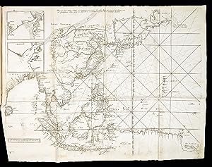
Hollandia Nova detecta 1644 Terre Australe decouverte l'an 1644.
Verlag: Jacques Langlois, chez G. Meturas, S. Piget, E. Langlois, T. Joly & L. Billaine,
Anbieter: Daniel Crouch Rare Books Ltd, London, Vereinigtes Königreich
Verbandsmitglied: ABA ILAB PBFA
Verkäuferbewertung 4 von 5 Sternen
Karte
EUR 21.446,36
EUR 23,14 Versand
Versand von Vereinigtes Königreich nach USAAnzahl: 1 verfügbar
In den WarenkorbAustralia revealed Third state. Double-page engraved map. One of the first printed records of Abel Tasman's discoveries of the Australian coastline, published in the first edition of Melchisedec Thevenot's 'Relations de Divers Voyages Curieux qui n'ont point esté publiées, ou qui ont esté traduites d'Hacluyt, de Purchas et d'autres voyages Anglais, Hollandais, Portugais, Allemands, Espagnols, et de quelques Persans, Arabes et auteurs orientaux' (1663). Based on Joan Blaeu's wall map of Asia and Australia, 'Archipelagus Orientalis, sive Asiaticus' (1659), Australia's "birth certificate", and the progenitor of the shape of the nation for 100 years. The 'Relations', was a monumental collection of voyages and exploration, a continuation of the compilations of Haklyut and Purchas, with the addition of accounts of exploration in the southern oceans, the East Indies, China and Arabia, and intended to help France achieve her colonial and international trade ambitions. Issued in five parts over more than thirty years, between 1663 and 1696. Part I included an account of one of the truly legendary voyages undertaken in perilously small open boats, Pelsaert's voyage from the Abrolhos to Batavia in June and July of 1629, an extraordinary feat of endurance in extremis, and illustrated with the large folding map 'Terre Avstrale decouverte l'an 1644', as here. 'Hollandia Nova, detecta 1644' - New Holland, revealed 1644 shows the western side of the continent, and a vast expanse between New Guinea, New Zealand and Van Dieman's Land, is designated 'Terre Australe, decouverte l'an 1644' - Terra Australia, discovered 1644. Thevenot, expanding on Blaeu, divides the continent in two at longitude 135 E. The line "separating 'Hollandia Nova' and 'Terre Australe' correlated to the western limit of Spanish claims in the South Pacific arising from the Treaty of Tordesillas of 1494. Thevenot was essentially reusing the Spanish boundary to open up the land east of New Holland to French interests. In effect, he was signaling what many in the French administration were then advocating: that France should emulate the Dutch in ensuring that the fledgling French East India Company had access to foreign markets. when the British government drew up the boundaries of the colony of New South Wales in 1788, it set the western limit at the meridian of 135 degrees east of Greenwich, just as it appeared on Thevenot's map" (Woods). This is a fine example of the third state with an unusually wide left-hand margin, in which rhumb lines have been added for the first time, and the error in degrees of latitude has been corrected. The mapmakers Abel Jansz. Tasman (c1603-1659), was the first European explorer to reach and map the coastlines of Tasmania and New Zealand. After a series of shipwrecks had revealed some of the western coast of Australia, he was chosen by Anthony van Diemen, governor-general of the Dutch East Indies, to lead a voyage of discovery to the south, in 1642. The intention was to find a sea route south of Nuyts land, and east across the Pacific to South America. In his ships, the 'Heemskerck' and 'Zeehaen', over a course of ten months, Tasman mapped the coast of southwest Tasmania, the west coast of New Zealand, and the island groups of Tonga and New Guinea. A second voyage, in 1644, Tasman and crew surveyed the southwest coast of New Guinea, and much of Australia's northern coastline, as here. Although the longed for southern sea route was not found, the easterly's were too strong, Tasman was awarded the rank of commandeur on his return, and a pay rise was backdated to the beginning of his first voyage. Subsequently, Tasman was "appointed to the Council of Justice at Batavia. In mid-1647 he was sent on a mission to the King of Siam and was granted precedence over all Dutchmen in the kingdom. After that mission, he was given command of a fleet of eight vessels which sailed in May 1648 against the Spaniards. His conduct in this operation was unsatisfactory and, after his return in January 1649, proceedings were taken against him for having, when inflamed by liquor, treated one of his sailors in a barbarous way; as a result, he was removed from office during the governor-general's pleasure. He was formally reinstated in January 1651, but not long afterwards retired from the service and became a merchant in Batavia. He died there in affluent circumstances in 1659" (Forsyth). Melchisedech Thevenot (1620-1692) was a French diplomat, scientist, and travel writer. He was a scholar with interests in mathematics, physics, and medicine, acting as the patron of several early scientific societies and most notably contributing to the formation of the Academie des Sciences. His early career included two missions to Italy in the 1640s and 1650s, and it was there that he first developed an interest in the study of Oriental languages. In 1663, he published the first part of his 'Relations de Divers Voyages', a work that would secure his reputation as one of the most important travel compilers of the seventeenth century. He would go on to publish a second and third part in 1666, a fourth in 1672, and a final fifth part was being assembled in 1692 when Thevenot died. Literature: Clancy, 'The Mapping of Terra Australis', 6.12; Clancy, 'So Came They South', page 132, 134-135, 138; Forsyth, 'Australian Dictionary of Biography', online; National Library of Australia, Woods, 'Mapping our World: Terra Incognita to Australia', page 143; Tooley, 'The Mapping of Australia', 1247.
-
Relations de divers voyages curieux, qui n'ont point esté publiées, ou qui on esté traduits d'Hacluyt, de Purchas, et d'autres voyageurs Anglais, Hollandois, Portugais, Allemands, Espagnols, et de quelques Persans, Arabes, et autres auteurs orientaux.
Verlag: chez André Cramoisy, 1666 - 1672, A Paris,, 1666
Anbieter: Daniel Crouch Rare Books Ltd, London, Vereinigtes Königreich
Verbandsmitglied: ABA ILAB PBFA
Verkäuferbewertung 4 von 5 Sternen
EUR 41.701,26
EUR 23,14 Versand
Versand von Vereinigtes Königreich nach USAAnzahl: 1 verfügbar
In den WarenkorbThe most up-to-date practical knowledge on navigation and information on foreign countries 4 volumes in 2. Folio (334 by 230mm). Text in French and Greek, title-pages printed in red and black, 3 of the 4 title-pages match those for the fourth part, and are dated 1672 (see Brunet V, 810), with original Roman numerals (1663 and 1664) altered in early manuscript; full vellum over paste- board, title in manuscript of the spines, some minor restoration. Volume one, part I: pp. [8] 52, 40, 12, 80, 30, 24, 35 [1], 52, XXV [3] with 3 large folding engraved maps, and illustrations throughout; without Routier des Indes orientales, but with Description des Pyramides d'Egypte, and numerous tables related to China; part II: pp. [16] 20, 60, 128, 40, 16, 48, 4, 26 with 10 folding engraved plates including 2 large folding maps, and some folding tables. Collation. Part I: [4] leaves, 52 pages, with map of Colchide; 1-26; 17-40; 12 pages with map of India under Mogol; 80 pages; 30 pages; 1-10; 19-24; 17-24; 35 pages; [1] page; 56 pages with map of Australia; XXV; [1] with two plates of Egyptian mummies; bound without 2 plates with Caldean characters, and one map of Bassora. Part II: [8] leaves, 20 pages; 60 pages with 4 plates of Arabic coasts; 128 pages with map of Serloine; 40 pages with map of China and Philippines; 16 pages; 48 pages with plate justice en iapon between pages 45 and 46; 4 pages; 26 pages; bound without, 1 map of Arabia, 1 map of Pegu et Japon, and 2 leaves of text (pages 27-30, last part on China). Volume two, part IV: La science des Chinois with its own title-page; pp. [4] 14, 24, 16, 16, 8, [4] 58, 40, 23 [1], 24, 4 with one folding engraved plate; part III: engraved frontispiece titled Ambassade des Hollandois a la Chine (1666); pp. [8] 68, 216, 12 with 15 engraved plates, including 2 large folding maps, and one folding table. Part IV: [2] leaves, 14 pages; 24 pages; 16 pages; 16 pages; 8 pages; 4 pages; map of the Red Sea; 46 pages with 63 plates and pages 47-58 of text; 23 pages; 24 pages; 4 pages, 2 plates with animals and plants from China; bound without: frontispiece particulier du voyage du sieur Acarette, ??? 23 of 24 pages of Viaggio del P. Grueber including the plate of the Chinese alphabet, with only the French translation of the account and map of Ethiopia. Part III: 1 leaf; [3] leaves; 28 pages; pages 31-68 with plate of the route (bound between pages 26 and 27 of following work); map of China; 216 pages; 12 pages; 10 plates not called for by Brunet, from the Voyage des ambassadeurs bound at the end; bound without the frontispiece to the part III, 2 leaves of text at the end of the first avis, 2 plates from the Voyage des ambassadeurs. Thevenot's monumental collection of voyages and exploration: a continuation of Haklyut and Purchas, and with the addition of accounts of exploration in the southern oceans, the East Indies, China and Arabia. His compilation was issued in five parts over more than thirty years: part I in 1663, part II in 1664, part III in 1666, part IV during 1672-1674, and part V in 1696. During the course of publication, the parts of the collection already printed were reissued with new title-pages in 1664, 1666, 1672 [as here], 1683, and 1696. Some sheets were reprinted for these reissues, and any two examples, issued before 1683, are rarely the same, with some "inserts" being more scarce than others. The current example is as originally issued, and seems to be composed of sheets for the 1666 re-issue, with new title-pages to parts I, II, and IV. It has been bound without some maps and inserts found in other examples, but is with others not so commonly found (see 'Collation'). Of all the truly legendary voyages undertaken in perilously small open boats, Pelsaert's voyage from the Abrolhos to Bavatia in June and July of 1629 is an extraordinary feat of endurance in extremis. The current set includes the very rare 'La Terre Avstrale decovverte par le Capitaine Pelsart, qui y fait naufrage': just seven pages that recount the tragedy of shipwreck, the bloody savagery of mutiny, Pelsaert's extraordinary journey, and the viscious aftermath of just retribution. The account is illustrated with the large folding map 'Terre Avstrale decouverte l'an 1644', after Tasman, here in its third state, with the Tropic of Capricorn and rhumb lines, 1672. Other important maps include: the second printing of an important untitled map of the East Indies, after Teixeira's chart which had been prepared in the 1640s for Portuguese cartographers. Drawn in the same style as a portolan, with no inland details, there are two insets showing the Ganges Delta and Chittagong, Hokkaid is shown as an island north of Japan ("Iezo"); 'Imperii Sinarum Nova Descriptio, a map of China', including Korea, Taiwan and Japan, drawn after the work of Martino Martini as published by the Blaeus, but showing Hokkaid joined to the mainland; and 'Ioao Teixeira Cosmographo de Sua Magestade Afex em Lixboa O Anno de 1649', an important chart of the entire east coast of Africa, the Arabian Peninsula, Persia, the west coast of India and adjacent Indian Ocean islands, one of the few printed charts taken directly from Portuguese sources, based upon a 1649 portolan chart by Joăo Teixeira, royal cosmographer of Portugal. One of the great driving forces behind 'Divers voyages' was Thévenot's desire to help France achieve her aim to increase colonial trade to compete with other European nations. The book aimed to gather together the most up-to-date practical knowledge on navigation and information on foreign countries. Melchisedech Thévenot (1620-1692) was a French diplomat, scientist, and travel writer. He was a scholar with interests in mathematics, physics, and medicine, acting as the patron of several early scientific societies and most notably contributing to the formation of the Académie des Sciences. His early career included two missions to Italy in the 1640s and 1650s, and it was there that he first develo.
-
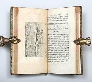
L'Art de Nager, demontre par figures, Avec des avis pour se baigner utilement.
Verlag: Paris: chez Thomas Moette, 1696, 1696
Anbieter: Peter Harrington. ABA/ ILAB., London, Vereinigtes Königreich
Verbandsmitglied: ABA ILAB PBFA
Verkäuferbewertung 5 von 5 Sternen
Erstausgabe
EUR 4.170,13
EUR 25,45 Versand
Versand von Vereinigtes Königreich nach USAAnzahl: 1 verfügbar
In den WarenkorbFirst edition of the first French book on swimming and one of the earliest books on the subject in an era when most Europeans, even sailors, could not swim. The book was widely read during the 18th century, including by Benjamin Franklin, an avid swimmer in his youth. The book is illustrated with 35 engraved plates by Charles Moette of people swimming. Thévenot describes a breaststroke executed with the face out of the water and an underwater arm recovery (the stage of a stroke when the limbs relax and return to the starting position). After the English translation of Thevenot's work became the standard swimming reference, the breaststroke remained the most common stroke used by swimmers for centuries. In his preface, Thévenot rightly claims his book to be the first on the subject in French, the only preceding works known to him in any language being Nicolas Wynman's Colymbetes (1538) and Sir Everard Digby's short Latin tract De arte natandi (1589, translated into English in 1595). Thévenot, who was a scientist, traveller, cartographer, orientalist, inventor, and diplomat, is often confused with his nephew, the traveller Jean de Thévenot. Duodecimo (149 x 82 mm). With 35 engraved plates. Attractive 18th-century French mottled calf, spine gilt in compartments with flower tools, sides with triple gilt rules, marbled endpapers, gilt edges. Engraved bookplate of Jean-François Gillet, écuyer (squire), 1778; small modern MK bookplate. A little rubbing to extremities, title leaf lightly spotted, else an excellent copy of this charming book.
-
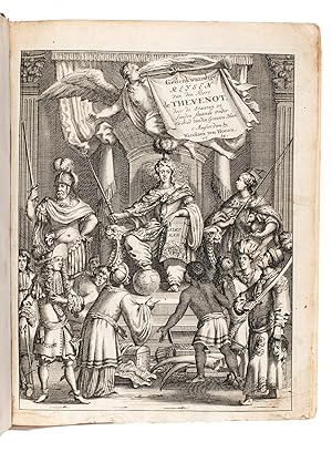
Alle de gedenkwaardige en zeer naauwkeurige reizen ; mitsgaders de voornaamster byzonderheden van d'Archipel, Konstantinopolen, 't Heilige Land, Egypten, de woestynen van Arabie, Mekka Uit het Fransch vertaald door G. v. Broekhuizen. Met fraye printverbeeldingen door J. Luiken,
Verlag: Gerrit Bos,, Amsterdam,, 1731
Anbieter: ASHER Rare Books, T Goy Houten, Niederlande
Verkäuferbewertung 5 von 5 Sternen
EUR 2.500,00
EUR 25,00 Versand
Versand von Niederlande nach USAAnzahl: 1 verfügbar
In den WarenkorbFirst volume (of three as numbered, but intended for binding as two) of Thévenot's travels in the Levant in the years 1655 to 1659, including Constantinople, the Holy Land and Egypt, and his further travels to Arabia, Mecca and elsewhere. In the Dutch editions volume 1 is more extensive than volumes 2 and 3, and in the 1723/24 and 1731 editions (both called the second edition on the title-pages) volume 3 has only a divisional title-page, so it was clearly the intention to bind volumes 2 and 3 together, making two volumes of about equal length. The present copy is volume 1 of this 1731 edition.With an 18th-century(?) bookseller's note on an endleaf. With marginal chips in the engraved title-page, a few leaves somewhat browned, but in good condition and with large margins. The binding is worn. A detailed account of travels in the Levant, beautifully illustrated from the plates made for it by Jan Luyken in 1681.l V. Eeghen & V.d. Keller 47 note; Klaversma & Hannema 1416; Landwehr 258 note; Tiele, Bibl. 1090 note. 18th-century half calf (sewn on 4 cords), sprinkled-paper sides, refurbished in the 19th century and with a 20th-century spine label. With engraved title-page, letterpress title-page with a woodcut ornament, standing portrait of the author in Eastern garb (with globe, map and his coat of arms), 19 engraved plates (including 2 folding) drawn, etched and engraved by Jan Luyken, 2 woodcut decorated initials (2 series). Set in textura types with incidental roman and italic. Pages: [4], 484, [4] pp.