
Gesamtpreis (1 Artikel Artikel):
Versandziel:

taride (296 Ergebnisse)
Direkt zu den wichtigsten Suchergebnissen
Suchfilter
Produktart
- Alle Product Types
- Bücher (97)
- Magazine & Zeitschriften (Keine weiteren Ergebnisse entsprechen dieser Verfeinerung)
- Comics (Keine weiteren Ergebnisse entsprechen dieser Verfeinerung)
- Noten (Keine weiteren Ergebnisse entsprechen dieser Verfeinerung)
- Kunst, Grafik & Poster (1)
- Fotografien (2)
- Karten (189)
- Manuskripte & Papierantiquitäten (7)
Zustand Mehr dazu
Weitere Eigenschaften
- Erstausgabe (2)
- Signiert (Keine weiteren Ergebnisse entsprechen dieser Verfeinerung)
- Schutzumschlag (1)
- Angebotsfoto (237)
Sprache (5)
Gratisversand
Land des Verkäufers
Verkäuferbewertung
-

PAP. Zustand: New. New Book. Shipped from UK. Established seller since 2000.
-
Paris-Fumeur
Anbieter: PBShop.store UK, Fairford, GLOS, Vereinigtes Königreich
Verkäuferbewertung 5 von 5 Sternen

EUR 17,74
EUR 3,86 Versand
Versand von Vereinigtes Königreich nach USAAnzahl: 15 verfügbar
In den WarenkorbPAP. Zustand: New. New Book. Shipped from UK. Established seller since 2000.
-
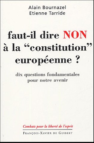
Faut-il dire non ŕ la constitution européenne: Dix questions fondamentales pour notre avenir
Sprache: Französisch
Verlag: Francois-Xavier de Guibert, 2005
ISBN 10: 2755400013 ISBN 13: 9782755400014
SonderangebotEUR 5,01
EUR 16,50 Versand
Versand von Frankreich nach USAAnzahl: 1 verfügbar
In den WarenkorbSoftcover. Zustand: Bon. Ancien livre de bibliothčque. Petite(s) trace(s) de pliure sur la couverture. Salissures sur la tranche. Edition 2005. Ammareal reverse jusqu'ŕ 15% du prix net de cet article ŕ des organisations caritatives. ENGLISH DESCRIPTION Book Condition: Used, Good. Former library book. Slightly creased cover. Stains on the edge. Edition 2005. Ammareal gives back up to 15% of this item's net price to charity organizations.
-

Nouvelle carte de France, Belgique, bords du Rhin, Suisse, etc. . cartes routieres pour automobilistes, cyclistes, etc.
Verlag: Paris: Taride, [ca. 1914]. Large folding map in color: 87 x 103 cm., scale 1:265,000., 1914
Anbieter: Viator Used and Rare Books, Burlington, NC, USA
Verkäuferbewertung 5 von 5 Sternen
Insets with French colonies: Africa, Madascar, Oceania, New Caledonia, Indochina, Guiana, Guadeloupe, Martinique, St. Pierre-Miquelon, and separate inset for Algeria and Tunisia. Not dated but internal evidence suggests pre World War I date (treatment of Alsace-Lorraine). Large stain (paint?) in upper left margin, smaller stain in bottom margin, some small tears at outer edges, some soil, "x' marks on map (possibly used in World War I), some stains on verso and owner's name; otherwise map surface is in good condition.
-

Carte Routiere No. 9 Bretagne ( Sud)
Sprache: Englisch
Verlag: Cartes Taride, 1111
Anbieter: Our Kind Of Books, Liphook, Vereinigtes Königreich
Verkäuferbewertung 5 von 5 Sternen
EUR 12,08
EUR 25,97 Versand
Versand von Vereinigtes Königreich nach USAAnzahl: 1 verfügbar
In den WarenkorbSoft cover. Zustand: Very Good. No Jacket. This map is in very good condition. Tanning and some creasing present to the maps paper envelope. Otherwise a very good clean copy.
-
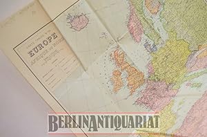
Europe, Afrique du Nord.
Verlag: C. Michard o.J. (ca. 1942)., Paris, 1942
Anbieter: BerlinAntiquariat, Karl-Heinz Than, Berlin, Deutschland
Verkäuferbewertung 4 von 5 Sternen

Gefaltet. Französische Europa-Karte inklusive Nord-Afrika. Maßstab 1:6700000. Zahlreiche mitteleuropäische Städte sind mit Bleistift unterstrichen worden. Konfliktzonen in Russland sind eingezeichnet, aber nicht deutlich markiert. Da in Frankreich kein Unterschied zwischen besetztem Gebiet und Vichy-Zone gemacht wird und auch Belgien, Luxemburg und die Niederlande als unabhängige Staaten eingezeichnet sind, handelt es sich hierbei wohl um eine Karte, die die Grenzen von 1940 angibt. Die Karte hat einige Gebrauchsspuren, befindet sich aber insgesamt in einem guten Zustand. Siehe Foto. I Blatt.
-
Plan-Guide de Paris Repertoire des Rues Metropolitain Renseignements Indispensibles Ministeres, Ambassades et Consulats, Prefectures, Mairies, Police, Hopitaux, Postes et Telegraphes, Monuments, Musees, Parcs, Theatres et Attractions. Cartes Taride 1947.
Sprache: Französisch
Verlag: Cartes Taride,, London, England,, 1947
Anbieter: Tony Hutchinson, Seale, Vereinigtes Königreich
Verkäuferbewertung 5 von 5 Sternen
EUR 10,87
EUR 24,04 Versand
Versand von Vereinigtes Königreich nach USAAnzahl: 1 verfügbar
In den WarenkorbSoft cover. Zustand: Fair. 142 + 20 + xii pp. cover split at spine and detached, metro map attached (still in original folds) to front cover,20 numberd folded maps at rear very good + 10 other maps which are a bit worn.
-
Plan de Paris. Métropolitain, autobus, tramway, bateaux. Toutes les rues.
Verlag: Editions Taride. 1930., 1930
Anbieter: Loďc Simon, Blaison-Saint Sulpice, FR, Frankreich
Verkäuferbewertung 5 von 5 Sternen
(Sans le plan). Broché. 175 pages.
-
Carte routičre pour cyclistes et automobilistes Centre de la francetaride n11
Verlag: Sans date
Anbieter: Démons & Merveilles, Joinville, Frankreich
Verkäuferbewertung 5 von 5 Sternen
Zustand: Good. Trčs bon état. Sans date. Carte routičre pour cyclistes et automobilistes Centre de la France/Taride N°11. Good.
-
Plan-guide de Paris. Répertoire guide (sans plan) des rues de Paris et banlieue, ŕ l'usage du personnel de la R.A.T.P.
Verlag: Editions Taride. Vers 1950., 1950
Anbieter: Loďc Simon, Blaison-Saint Sulpice, FR, Frankreich
Verkäuferbewertung 5 von 5 Sternen
Renseignements indispensables, ministčre, ambassades et consulats, préfectures, Broché. 304 pages.
-
Plan-Guide R?pertoire des Rues ? Paris (1er Arrondissement) M?tro-Autobus ? c. mid-20th century
Anbieter: Blind-Horse-Books (ABAA), DeLand, FL, USA
Verbandsmitglied: ABAA ESA FABA ILAB IOBA
Verkäuferbewertung 5 von 5 Sternen
Zustand: Very Good. A compact Paris plan-guide combining detailed street maps with a directory of streets and integrated m?tro and autobus routes. Designed for practical navigation, this pocket guide covers central Paris with color-coded mapping, transit diagrams, and an alphabetical street index?an efficient tool for navigating the city in the pre-digital era. DETAILS: +++ Title: Plan-Guide R?pertoire des Rues ? Paris M?tro-Autobus +++ Publisher: Cartes Taride, Paris +++ Date: c. mid-20th century +++ Format: Flexible hardcover (pocket guide) +++ Size: 5.25 inches +++ Pagination: Indexed CONTENT HIGHLIGHTS: +++ Detailed color maps of Paris neighborhoods and arrondissements +++ Integrated m?tro and bus network diagrams +++ Alphabetical street directory with cross-references +++ Compact format designed for everyday urban navigation +++ Period cartography showing mid-century Paris layout CONDITION: Very Good. Bindings tight and square. Text clean with light, even age-toning. Moderate shelf handling wear. Previous owner?s name on first blank page. Historical Context ? Before the widespread use of digital navigation, compact guides such as those produced by Cartes Taride were essential tools for both residents and visitors in Paris. These guides combined cartography with transit information, reflecting the increasing complexity of urban mobility in the 20th century. With the expansion of the m?tro and bus networks, such publications helped users efficiently navigate the city?s dense street system. Today, they serve as useful historical references for the development of Parisian transportation and urban geography. Subjects: Paris maps, m?tro system, bus routes, street directories, urban navigation, French cartography, mid-century Paris, travel guides, Ephemera, Cartography, Transportation.
-

Caerte Taride Routičre n° 17.Provence, Basses-Alpes.
Verlag: Cartes Taride
Anbieter: Tiré ŕ Part, Marseille, Frankreich
Verkäuferbewertung 5 von 5 Sternen
Carte routičre Taride n° 17. Provence, Basses-Alpes.Tirage en 5 couleurs.Echelle 1/250000e.Sur papier simili-Japon. Carte Géographie.
-
LES 60 PLUS BELLES PROMENADES AUTOUR DE PARIS
Erscheinungsdatum: 1942
Anbieter: Librairie Philosophique J. Vrin, Paris, Frankreich
Verkäuferbewertung 4 von 5 Sternen
Couverture souple. Zustand: Satisfaisant. Guide Taride des environs de Paris pour automobilistes, motocyclistes et cyclistes.Les 60plus belles promenades autour de Paris.Itinéraires détaillés, kilométrés et documentés. Circuits de 30 ŕ 250 km (adaptés pour cyclistes). Avec schémas d'orientation.9e éd.P., 1942, in-12, br., signet, couv. lég. défr. 200 gr.
-
Cartes Taride. No. 1. Belgique. Plans - Guides - Cartes [Toute La France en 25 Sections]
Sprache: Französisch
Verlag: Cartes Taride, 18 et 20 Boulevard St-Denis, Paris, 1930
Anbieter: K Books Ltd ABA ILAB, York, YORKS, Vereinigtes Königreich
Verbandsmitglied: ABA ILAB PBFA
Verkäuferbewertung 5 von 5 Sternen
EUR 14,49
EUR 22,87 Versand
Versand von Vereinigtes Königreich nach USAAnzahl: 1 verfügbar
In den WarenkorbNo Binding. Zustand: Fair. Folding colour paper map one side only - 36 x 28 inches, and folds down to 7.5 x 5 inches. Accompanying publisher's brown sleeve case with black lettering. The map has tears and holes at the folded seams and the cover is grubby and split, Cartes Taride, 18 et 20 Boulevard St-Denis, Paris, circa 1930.
-
Carte Taride. Routiere No. 1. Nord de la France, Belgique [Ouest] ? Hotels et Garages Recommandés
Sprache: Französisch
Verlag: Cartes Taride, 18 et 20 Boulevard St-Denis, Paris, 1930
Anbieter: K Books Ltd ABA ILAB, York, YORKS, Vereinigtes Königreich
Verbandsmitglied: ABA ILAB PBFA
Verkäuferbewertung 5 von 5 Sternen
EUR 14,49
EUR 22,87 Versand
Versand von Vereinigtes Königreich nach USAAnzahl: 1 verfügbar
In den WarenkorbNo Binding. Zustand: Fair. Folding colour paper map one side only - 36 x 28 inches, and folds down to 7.5 x 5 inches. Accompanying publisher's brown sleeve case with black lettering. The map has tears and holes at the folded seams and the cover is grubby and split, Cartes Taride, 18 et 20 Boulevard St-Denis, Paris, circa 1930.
-
France. Nord-Est.
Verlag: Editions Taride. Vers 1950., 1950
Anbieter: Loďc Simon, Blaison-Saint Sulpice, FR, Frankreich
Verkäuferbewertung 5 von 5 Sternen
Une feuille repliée. 80x80 cm. En couleurs.
-
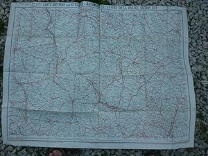
Centre de la France. Section Sud-Ouest au 1/250 000e. Carte routičre pour cyclistes et automobilistes.
Verlag: Editions Taride.
Anbieter: Loďc Simon, Blaison-Saint Sulpice, FR, Frankreich
Verkäuferbewertung 5 von 5 Sternen
Sans date. Une feuille 78x95 cm. Plis réparés.
-
Carte Taride 76 Routes & Plans des villes principales de la France-Moitié-Nord
Verlag: Sans date
Anbieter: Démons & Merveilles, Joinville, Frankreich
Verkäuferbewertung 5 von 5 Sternen
Zustand: Good. Etat correct. Sans date. Good.
-
Centre de la France, section Ouest. Numéro 12.
Verlag: Vers 1916., 1916
Anbieter: Loďc Simon, Blaison-Saint Sulpice, FR, Frankreich
Verkäuferbewertung 5 von 5 Sternen
Echelle 1/250 000č. Une feuille. 101x72 cm en pochette.
-
Est de la France. Carte pour automobilistes et cyclistes.
Verlag: Editions Taride. Vers 1900., 1900
Anbieter: Loďc Simon, Blaison-Saint Sulpice, FR, Frankreich
Verkäuferbewertung 5 von 5 Sternen
Une feuille défraîchie. 70x90 cm repliée en pochette.
-
Carte routičre pour automobilistes et cyclistes. Environs de Paris. Nord-Est au 1/100 000e (80km). .
Verlag: Editions Taride. Vers 1900., 1900
Anbieter: Loďc Simon, Blaison-Saint Sulpice, FR, Frankreich
Verkäuferbewertung 5 von 5 Sternen
Une feuille 70x90 cm en pochette.
-
Carte routičre pour automobilistes et cyclistes. Environs de Paris section N-E, au 1/250 000e.
Verlag: Editions Taride. Vers 1900., 1900
Anbieter: Loďc Simon, Blaison-Saint Sulpice, FR, Frankreich
Verkäuferbewertung 5 von 5 Sternen
Carte Numéro 3. Une feuille 70x90 cm en pochette.
-
CARTE TARIDE. ROUTIERE NO. 11. BOURGOGNE, NIVERNAIS [FRANCE] A' L'USAGE DES CYCLISTES ET AUTOMOBILISTES
Verlag: Cartes Taride, Paris, 1924
Anbieter: Live Oak Booksellers, Langley, WA, USA
Verkäuferbewertung 5 von 5 Sternen
Soft cover. Zustand: Very Good+. Map 35 x 26" (88 x 66 cm.) printed in color one side and mounted on linen that folds to about the size of a business envelope. Scale: 1:250, 000, 000. Outer front panel has a label with the title and publisher, the outer rear panel has a label advertising other maps by the same publisher. Map is somewhat soiled on the outside, interior is near fine with no markings. Date determined from contents. In unusually good condition for a map of such age.
-
Cartes Taride. Grande Carte Routičre. Les Bords du Rhin (3 Cartes - Complet) Les Bords du Rhin. N°26 : De Cologne ŕ Mayence ; N°27 : De Mayence ŕ Strasbourg ; N° 28 : Strasbourg ŕ Bâle et ŕ Constance. A l'usage des Automobiles, Cyclistes, Touristes.
Sprache: Französisch
Verlag: A. Taride, 1910
Anbieter: Librairie du Cardinal, GRADIGNAN, Frankreich
Verkäuferbewertung 5 von 5 Sternen
souple. Zustand: Bon. Echelle du 1/350 000e, tirage en 3 couleurs, grands itinéraires pour automobiles, Lignes de chemins de fer, 3 cartes sous étui papier, A. Taride, s.d. (circa 1910) Intéressant lot des 3 cartes Taride sur les Bords du Rhin. Bon état. Prix pour l'ensemble. Langue: Français.
-
Carte routičre n° 9. Bretagne (Sud) au 1/250 000čme.
Verlag: Paris.
Anbieter: Loďc Simon, Blaison-Saint Sulpice, FR, Frankreich
Verkäuferbewertung 5 von 5 Sternen
Sans date. Une feuille entoilée. 90x76 cm. Tachée.
-
Carte routičre n°19 au 1/250 000čme pour automobilites et cyclistes : Midi de la France, section Ouest.
Verlag: Vers 1900., 1900
Anbieter: Loďc Simon, Blaison-Saint Sulpice, FR, Frankreich
Verkäuferbewertung 5 von 5 Sternen
Début XXe. Une feuille. 90x68 cm.
-

Collection Des Guides-Taride. Les Routes de France: Ŕ l'Usage Des Cyclistes Et Des Conducteurs d'Automobiles (French Edition)
Anbieter: Ria Christie Collections, Uxbridge, Vereinigtes Königreich
Verkäuferbewertung 5 von 5 Sternen
EUR 40,34
EUR 14,05 Versand
Versand von Vereinigtes Königreich nach USAAnzahl: Mehr als 20 verfügbar
In den WarenkorbZustand: New. In.
-
Carte routičre numéro 25 : Alsace-Lorraine. Echelle 1/300 000čme. Tirage en couleurs. Routes numérotées, kilométrés et signalisées.
Verlag: Taride. Sans date.
Anbieter: Loďc Simon, Blaison-Saint Sulpice, FR, Frankreich
Verkäuferbewertung 5 von 5 Sternen
Une feuille repliée. 91x72 cm. Plis réparés.
-
Carte Taride. Routiere No. 3. Environs de Paris (Nord-Est) ? Hotels et Garages Recommandés
Sprache: Französisch
Verlag: Cartes Taride, 18 et 20 Boulevard St-Denis, Paris, 1930
Anbieter: K Books Ltd ABA ILAB, York, YORKS, Vereinigtes Königreich
Verbandsmitglied: ABA ILAB PBFA
Verkäuferbewertung 5 von 5 Sternen
EUR 18,12
EUR 22,87 Versand
Versand von Vereinigtes Königreich nach USAAnzahl: 1 verfügbar
In den WarenkorbNo Binding. Zustand: Good. Folding colour paper map one side only - 36 x 28 inches, and folds down to 7.5 x 5 inches. Accompanying publisher's brown sleeve case with black lettering. The map has tears and holes at the folded seams and the cover is grubby and split, Cartes Taride, 18 et 20 Boulevard St-Denis, Paris, circa 1930.
-
Bourgogne-Franche-Comté. Frontičre Suisse-Lac de Genčve.
Verlag: Taride. Sans date.
Anbieter: Loďc Simon, Blaison-Saint Sulpice, FR, Frankreich
Verkäuferbewertung 5 von 5 Sternen
Echelle 1/250.000čme. Numéro 10. Une feuille repliée. 80x72cm.


![Bild des Verkäufers für Cartes Taride. No. 1. Belgique. Plans - Guides - Cartes [Toute La France en 25 Sections] zum Verkauf von K Books Ltd ABA ILAB](https://pictures.abebooks.com/inventory/md/md32248986320.jpg)
![Bild des Verkäufers für Carte Taride. Routiere No. 1. Nord de la France, Belgique [Ouest] ? Hotels et Garages Recommandés zum Verkauf von K Books Ltd ABA ILAB](https://pictures.abebooks.com/inventory/md/md32248988301.jpg)


