

Gesamtpreis (1 Artikel Artikel):
Versandziel:

tanner warr (2 Ergebnisse)
Direkt zu den wichtigsten Suchergebnissen
Suchfilter
Produktart
- Alle Product Types
- Bücher (1)
- Magazine & Zeitschriften (Keine weiteren Ergebnisse entsprechen dieser Verfeinerung)
- Comics (Keine weiteren Ergebnisse entsprechen dieser Verfeinerung)
- Noten (Keine weiteren Ergebnisse entsprechen dieser Verfeinerung)
- Kunst, Grafik & Poster (Keine weiteren Ergebnisse entsprechen dieser Verfeinerung)
- Fotografien (Keine weiteren Ergebnisse entsprechen dieser Verfeinerung)
- Karten (1)
- Manuskripte & Papierantiquitäten (Keine weiteren Ergebnisse entsprechen dieser Verfeinerung)
Zustand Mehr dazu
- Neu (Keine weiteren Ergebnisse entsprechen dieser Verfeinerung)
- Wie Neu, Sehr Gut oder Gut Bis Sehr Gut (Keine weiteren Ergebnisse entsprechen dieser Verfeinerung)
- Gut oder Befriedigend (Keine weiteren Ergebnisse entsprechen dieser Verfeinerung)
- Ausreichend oder Schlecht (Keine weiteren Ergebnisse entsprechen dieser Verfeinerung)
- Wie beschrieben (2)
Einband
- alle Einbände
- Hardcover (Keine weiteren Ergebnisse entsprechen dieser Verfeinerung)
- Softcover (Keine weiteren Ergebnisse entsprechen dieser Verfeinerung)
Weitere Eigenschaften
- Erstausgabe (Keine weiteren Ergebnisse entsprechen dieser Verfeinerung)
- Signiert (Keine weiteren Ergebnisse entsprechen dieser Verfeinerung)
- Schutzumschlag (Keine weiteren Ergebnisse entsprechen dieser Verfeinerung)
- Angebotsfoto (2)
Sprache (1)
Preis
- Beliebiger Preis
- Weniger als EUR 20 (Keine weiteren Ergebnisse entsprechen dieser Verfeinerung)
- EUR 20 bis EUR 45 (Keine weiteren Ergebnisse entsprechen dieser Verfeinerung)
- Mehr als EUR 45
Gratisversand
- Kostenloser Versand nach USA (Keine weiteren Ergebnisse entsprechen dieser Verfeinerung)
Land des Verkäufers
Verkäuferbewertung
-
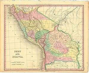
Peru and Bolivia.
Verlag: PhiladelphiaTanner. -46, 1836
Anbieter: Robert Frew Ltd. ABA ILAB, London, Vereinigtes Königreich
Verbandsmitglied: ABA ILAB PBFA
Verkäuferbewertung 5 von 5 Sternen

Karte
EUR 89,14
EUR 11,54 Versand
Versand von Vereinigtes Königreich nach USAAnzahl: 1 verfügbar
In den Warenkorb29 x 35 cm. Original colour. Single page map of Peru and Bolivia. Very good condition.
-
Egypt &c
Verlag: Philadelphia, 1842
Anbieter: Argosy Book Store, ABAA, ILAB, New York, NY, USA
Verkäuferbewertung 5 von 5 Sternen
unbound. W. W. Warr (illustrator). Map. Engraving with hand coloring. Image measures 14 1/2 x 11 1/2" Lovely map of Egypt divided into counties with a plethora of notations on ruins, trails, and pyramids, reflecting Egyptomania of the Victorian period. Shows towns, major routes and geographic features. The gulf of Suez and the Red Sea are included as well as Gaza and the Dead Sea in Palestine. This map is in very good condition, with minor overall toning and some stains. Henry Schenck Tanner (1786-2858) was an American cartographer and statistical geographer. Born in New York, he moved to Philadelphia where he established his well-known publishing company with his brother. Tanner was the first American to publish a map of Texas, which subsequently went through eight editions. However, he is best known and most renowned for his New American Atlas.

