

Gesamtpreis (1 Artikel Artikel):
Versandziel:

stiles sherman (6 Ergebnisse)
Direkt zu den wichtigsten Suchergebnissen
Suchfilter
Produktart
- Alle Product Types
- Bücher (5)
- Magazine & Zeitschriften (Keine weiteren Ergebnisse entsprechen dieser Verfeinerung)
- Comics (Keine weiteren Ergebnisse entsprechen dieser Verfeinerung)
- Noten (Keine weiteren Ergebnisse entsprechen dieser Verfeinerung)
- Kunst, Grafik & Poster (Keine weiteren Ergebnisse entsprechen dieser Verfeinerung)
- Fotografien (Keine weiteren Ergebnisse entsprechen dieser Verfeinerung)
- Karten (1)
- Manuskripte & Papierantiquitäten (Keine weiteren Ergebnisse entsprechen dieser Verfeinerung)
Zustand Mehr dazu
- Neu (1)
- Wie Neu, Sehr Gut oder Gut Bis Sehr Gut (1)
- Gut oder Befriedigend (2)
- Ausreichend oder Schlecht (Keine weiteren Ergebnisse entsprechen dieser Verfeinerung)
- Wie beschrieben (2)
Einband
Weitere Eigenschaften
- Erstausgabe (Keine weiteren Ergebnisse entsprechen dieser Verfeinerung)
- Signiert (Keine weiteren Ergebnisse entsprechen dieser Verfeinerung)
- Schutzumschlag (Keine weiteren Ergebnisse entsprechen dieser Verfeinerung)
- Angebotsfoto (5)
Sprache (2)
Preis
- Beliebiger Preis
- Weniger als EUR 20 (Keine weiteren Ergebnisse entsprechen dieser Verfeinerung)
- EUR 20 bis EUR 45
- Mehr als EUR 45
Gratisversand
- Kostenloser Versand nach USA (Keine weiteren Ergebnisse entsprechen dieser Verfeinerung)
Land des Verkäufers
Verkäuferbewertung
-

Mary Poppins
Anbieter: Revaluation Books, Exeter, Vereinigtes Königreich
Verkäuferbewertung 5 von 5 Sternen

EUR 32,07
EUR 14,42 Versand
Versand von Vereinigtes Königreich nach USAAnzahl: 2 verfügbar
In den WarenkorbPaperback. Zustand: Brand New. 00313303 edition. 154 pages. 12.00x9.00x0.75 inches. In Stock.
-
![Bild des Verkäufers für History of Ancient Wethersfield Connecticut, Volumes I [The History] & II [Geologies and Biographies] zum Verkauf von Genealogical Forum of Oregon](https://pictures.abebooks.com/inventory/md/md31281254572.jpg)
History of Ancient Wethersfield Connecticut, Volumes I [The History] & II [Geologies and Biographies]
Anbieter: Genealogical Forum of Oregon, Portland, OR, USA
Verkäuferbewertung 5 von 5 Sternen
Hardcover. Zustand: Very Good. Volume I - 1995 ISBN: 0897250737 Volume II - 1996 ISBN: 0897250860 Sold as a Volumes I & II volumes. Hardcover, black cloth binding with gold color stamp. Size: 9 1/4 X 6 1/4 inches. 1891 pages. Indexed. Very good condition.
-

THE HISTORY OF ANCIENT WETHERSFIELD CONNECTICUT COMPRISING THE PRESENT TOWNS OF WETHERSFIELD, ROCKY HILL, AND NEWINGTON; AND OF GLASTONBURY PRIOR TO ITS INCORPORATION IN 1693, FROM DATE OF EARLIEST SETTLEMENT UNTIL THE PRESENT TIME Volume I. - History
Verlag: Higginson Book Company N.D.
Anbieter: Easton's Books, Inc., Mount Vernon, WA, USA
Verkäuferbewertung 5 von 5 Sternen
Hardcover. Zustand: VG+. Reprint. Hardback in Very Good+ condition without dust jacket. 8vo 8" - 9" tall. 995 pages. Reprint of the 1904 edition published by The Grafton Press. Stamp of "Everett Wash. Stake Family History Center #047-012" on front free endpaper - otherwise, the interior is clean and unmarked. Light shelf wear. Small "89" to top of spine and upper corner of front board - see photo. Quick shipping, excellent customer service. All books carefully packaged in boxes and ship with tracking information.
-
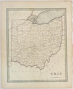
Ohio
Verlag: T.G. Bradford, Boston, 1838
Anbieter: Argosy Book Store, ABAA, ILAB, New York, NY, USA
Verkäuferbewertung 5 von 5 Sternen
unbound. S. Stiles, Sherman and Smith (illustrator). Map. Engraving with original hand colored outline. Image measures 14" x 11 1/4". Nice early map of Ohio divided into counties and townships showing major routes, railroads and geographical details. This is the first edition of this map. published in 1838. Minor overall wear, pinholes to right edge, faint scattered foxing. T.G. Bradford (1802-1887) was a Boston based publisher. He worked as assistant editor of the American Encyclopedia before entering the field of map making. He was best known for his 1835 "A Comprehensive Atlas: Geographical, Historical & Commercial" and his 1838 "Illustrated Atlas Geographical, Statistical and Historical of the United States and Adjacent Countries", both of which proved to be important contributions to American cartography.
-
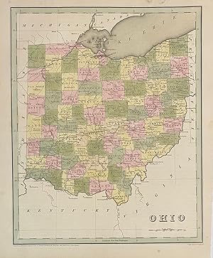
Ohio
Verlag: T.G. Bradford, Boston, 1838
Anbieter: Argosy Book Store, ABAA, ILAB, New York, NY, USA
Verkäuferbewertung 5 von 5 Sternen
unbound. S. Stiles, Sherman and Smith (illustrator). Map. Engraving with original hand coloring. Image measures 14" x 11 1/4". Nice early map of Ohio divided into counties and townships showing major routes, railroads and geographical details. This is the first edition of this map. published in 1838. In very good condition. Minimal foxing to margin, not affecting the image. T.G. Bradford (1802-1887) was a Boston based publisher. He worked as assistant editor of the American Encyclopedia before entering the field of map making. He was best known for his 1835 "A Comprehensive Atlas: Geographical, Historical & Commercial" and his 1838 "Illustrated Atlas Geographical, Statistical and Historical of the United States and Adjacent Countries", both of which proved to be important contributions to American cartography.
-

Map of Asia Designed to Accompany SMITH's Geography for School (Entered According to Act of Congress in the Year 1839 by xxx xxx in the Clerks Office of the Districk Court of Connecticut.
Karte
No Binding. Zustand: Fine. 30 x 24cm Map of Asia Designed to Accompany SMITH's Geography for School (Entered According to Act of Congress in the Year 1839 by xxx xxx in the Clerks Office of the Districk Court of Connecticut.

