Gesamtpreis (1 Artikel Artikel):
Versandziel:

spilbergen joris (20 Ergebnisse)
Direkt zu den wichtigsten Suchergebnissen
Suchfilter
Produktart
- Alle Product Types
- Bücher (18)
- Magazine & Zeitschriften (Keine weiteren Ergebnisse entsprechen dieser Verfeinerung)
- Comics (Keine weiteren Ergebnisse entsprechen dieser Verfeinerung)
- Noten (Keine weiteren Ergebnisse entsprechen dieser Verfeinerung)
- Kunst, Grafik & Poster (1)
- Fotografien (Keine weiteren Ergebnisse entsprechen dieser Verfeinerung)
- Karten (1)
- Manuskripte & Papierantiquitäten (Keine weiteren Ergebnisse entsprechen dieser Verfeinerung)
Zustand Mehr dazu
- Neu (1)
- Wie Neu, Sehr Gut oder Gut Bis Sehr Gut (Keine weiteren Ergebnisse entsprechen dieser Verfeinerung)
- Gut oder Befriedigend (2)
- Ausreichend oder Schlecht (Keine weiteren Ergebnisse entsprechen dieser Verfeinerung)
- Wie beschrieben (17)
Einband
Weitere Eigenschaften
- Erstausgabe (7)
- Signiert (Keine weiteren Ergebnisse entsprechen dieser Verfeinerung)
- Schutzumschlag (Keine weiteren Ergebnisse entsprechen dieser Verfeinerung)
- Angebotsfoto (16)
Sprache (3)
Gratisversand
Land des Verkäufers
Verkäuferbewertung
-
EUR 25,91
EUR 48,99 Versand
Versand von Deutschland nach USAAnzahl: Mehr als 20 verfügbar
In den WarenkorbZustand: New.
-

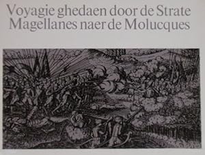
Voyagie ghedaen door de Strate Magellanes naer de Molucques.
Verlag: Amsterdam, 1970
Anbieter: Librería José Porrúa Turanzas S.A., Madrid, M, Spanien
Verkäuferbewertung 5 von 5 Sternen

Amsterdam, s.a. (c.1970). En folio oblongo. 118 pp., 5 grandes láminas plegadas y 17 láminas a toda página. Rústica. Edición facsimilar, muy bien publicada en Amsterdam hacia 1970 del famoso viaje del corsario Joris van Spilvergen que vircunavegó la tierra y saqueó Perú, Chile y Filipinas. Contiene la reproducción de los magníficos mapas originales.
-
Historisch journael vande voyage ghedaen met ses schepen, uytghereed zijnde door de . Oost-Indische Compaignie . omme te varen door de Strate Magallanes naer de Molucques . Onder 't gebiedt van . Joris van Spilbergen. Als mede de Australische navigatie, ontdekt door Jacob le Maire in den jaere 1615,1616,1617. Amsterdam, 1646. Reprint.
Anbieter: Gert Jan Bestebreurtje Rare Books (ILAB), Vianen, Niederlande
Verkäuferbewertung 5 von 5 Sternen
(Amsterdam, 1969). Oblong 8vo. Boards. With many plates and folding maps. 118 pp. - Facsimile edition from 'Begin ende voortgangh'.
-
De reis door Straat Magelhaes naar Oost-Indië en terug rond Zuid-Afrika in 1614-1617. Uitgegeven door R. Posthumus Meyjes.
Anbieter: Gert Jan Bestebreurtje Rare Books (ILAB), Vianen, Niederlande
Verkäuferbewertung 5 von 5 Sternen
Amsterdam, J.H. de Bussy, 1952. Cloth. With many folding maps and plates. XXXIX,231 pp. Between 1614 and 1617 Spilbergen traveled around the world on behalf of the VOC through the Strait Magellan.
-

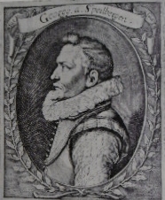
"Ad.m R.dus D. Mr. Stephanus Crachtuius Campensis." - Stephanus Crachtius (1570-1653) Kampen Amsterdam Portrait
Sprache: Latein
Verlag: ca. 1660., 1660
Anbieter: Antiquariat Steffen Völkel GmbH, Seubersdorf, Deutschland
Verkäuferbewertung 5 von 5 Sternen
Kunst / Grafik / Poster
Blatt-Maße: ca. 34 x 23 cm. -- Original Kupferstich-Portrait aus dem 17. Jh. -- gut erhalten. || Original engraved portrait from the 17th century. -- in good condition. // Wir, das Antiquariat Steffen Völkel, kaufen und verkaufen alte Bücher, Handschriften, Zeichnungen, Autographen, Grafiken und Fotografien. Wir sind stets am Ankauf von kompletten Bibliotheken, Sammlungen und Nachlässen interessiert. la Gewicht in Gramm: 20.
-
De reis om de wereld van Joris van Spilbergen 1614-1617.
Anbieter: Antiquariaat A. Kok & Zn. B.V., Amsterdam, Niederlande
Verkäuferbewertung 5 von 5 Sternen
's-Gravenhage, Martinus Nijhoff, 1943. 2 vols (text & plates) CXXXI,192 pp. 27 (fold.) b./w. plts & maps. Orig. uniform h.cloth, gilt lettered to spine. - Light shelfwear; back cover of vol. 2 partly waterstained along the edges; both vols with ex-libris. (Werken uitgegeven door de Linschoten-Vereeniging, 47).Complete set of two volumes (text & plates).
-
De reis van Joris van Spilbergen naar Ceylon, Atjeh en Bantam 1601-1604.
Anbieter: Antiquariaat A. Kok & Zn. B.V., Amsterdam, Niederlande
Verkäuferbewertung 5 von 5 Sternen
's-Gravenhage, Martinus Nijhoff, 1933. LVII,IV,126 pp. 19 maps & b./w. ills (incl. fold. plates). Orig. blind stamped blue cloth, lettered gilt to spine, gilt vignette to upper board. 8vo. - With two bookplates. (Werken uitgegegeven door de Linschoten-Vereeniging, 38).Issued with an Introduction by a preparatory committee consisting of F.C. Wieder, F.W. Stapel, S.P. L'Honoré Naber and Wouter Nijhoff. - Copy from the library of Jean Charles Pabst, KNIL officer and diplomat (The Hague 8-3-1873 - Tokyo 24-1-1942). His ex libris is mounted on the upper pastedown.
-
The East And West Indian Mirror, Being An Account Of Joris Van Spilbergen's Voyage Round The World (1614-1617), And The Australian Navigations Of Jacob Le Maire. Translated, with Notes and an Introduction By J.A.J. De Villiers.
Verlag: London: Printed For The Hakluyt Society [Second Series: No. 18], 1906., 1906
Anbieter: D & E LAKE LTD. (ABAC/ILAB), Toronto, ON, Kanada
Verkäuferbewertung 2 von 5 Sternen

Hardcover. 8vo. pp. with half-title. original blind & gilt-stamped cloth. lxi, [3 leaves], 272, 40. 31 folding maps & plates. original blind & gilt-stamped cloth. Cox I 52. Howgego S158. National Maritime Museum Cat. I 90.
-
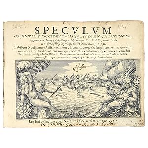
Speculum orientalis occidentalisque Indić navigationum; Quarum una Georgij ŕ Spilbergen classis cum potestate Prćfecti, altera Iacobi le Maire auspicijs imperioque directa, Annis 1614, 15, 16, 17, 18. Exhibens Noui in mare Australe transitus, incognitarumque hactenus terrarum ac gentium inuentionę: prćlia aliquot terra marique commissa, expugnationesq; vrbium: vna cum duabus nouis utriusque Indić Historijs, Catalogo munitionum Hollandicarum, ducum & reliqui bellici apparatus, Fretisque quatuor: suis qućque figuris ac imaginibus illustrata
Verlag: Nicolaes van Geelkercken for Jodocus Hondius, Leiden, 1619
Erstausgabe
Hardcover. Zustand: Very good. First. SPILBERGEN'S VOC CIRCUMNAVIGATION, BOUND WITH THE ARMS OF CHARLES I AS PRINCE OF WALES. First edition in Latin. Leiden: Nicolaes van Geelkercken for Jodocus Hondius, 1619. Oblong quarto (7" x 9 11/16", 179mm x 247mm). [Full collation available.] With 25 engravings (plus an allegorical engraving on the title-page): 6 folding maps, 1 folding view and 18 views. Bound in contemporary (pre-1625) panelled vellum with ties (renewed). Gilt supralibros of King Charles I as Prince of Wales within two double gilt fillet borders. Inner corner-ornaments of hearts set within scrollwork, outer corner-ornaments of thistle. On the spine, six panels separated by triple gilt fillets. Top and bottom edges of the text-block gilt (traces of gilding to the fore). Small loss at the tail. Ties and end-papers renewed. Faint signs of damp along the upper edge to quire D, with mild tanning and a very little worming, just touching a few letters. Repaired worming to the central fold of the world map, and general repairs to the folds of other maps and views. Quires A and Y reinserted, with a split at X3,4. Joris van Spilbergen (1568-1620) was in the first generation of explorers for the Dutch East India Company (Vereenigde Oostindische Compagnie or VOC), beginning in fact in the company of one of its founders, Balthazar de Moucheron. After a successful voyage to the East Indies (particularly Kandy, modern Sri Lanka) in 1604, he was sent in August of 1614 by the newly-formed VOC to return via Brazil and the Straits of Magellan. Fighting along the way with the Spanish, particularly up the west coast of South America and up to Acapulco in Mexico, Spilbergen came to the East Indies in early 1616. In October of 1616 he encountered the expedition of Jacob Le Maire (son of Isaac, once a director of the VOC but driven out), who had sailed via the strait that would be named for him as part of the rival Australische Compagnie. Le Maire's ships and booty were seized and sent along with Spilbergen's fleet, returning to the Netherlands in July of 1617. The present work, likely edited by Nicolaes van Geelkercken and doubtless illustrated by him, combines the accounts of rivals Spilbergen and Le Maire. The engravings, including the particularly celebrated world map showing the routes of Spilbergen (and Le Maire, before being subsumed), are unusually well-integrated with the text, with keys specifying aspects of the images. Beside the valuable records of individual harbors and coastlines, the work is profoundly entertaining, with its tales of battles by day and night against the Spanish, coastal raids and other feats of swashbuckling. Books bound with the arms of a sovereign -- or, as here, a future sovereign -- always raise the question of ownership: was this owned by Charles I (r. 1625-1649) as Prince of Wales, presented by him to someone else, or simply bound by a staunch royalist? The stamp used (his stamp no. 04 in the British Armorial Bindings database) excludes the last; its use on an example of Rosa Hispani-Anglica, which was dedicated to him as Prince of Wales, now in the British Library (C.46.f.1.), suggests that he may have used it personally. In the year of his accession to the throne, Charles I concluded three military agreements with the Netherlands: two for naval warfare (the second explicitly against the Spanish), one against the Austrian Hapsburgs. Thus the present volume may well have been to hand as he considered the consequences of those alliances. At the very least it will have amused the prince. Alden & Landis 619/133; Borba de Moraes II:276; Landwehr, VOC 391; Sabin 89450.
-
Speculum orientalis occidentalisque Indiae navigationum; quarum una Georgii a Spilbergen classis cum potestate praefecti, altera Iacobi le Maire auspiciis imperioque directa, annis 1614, 15, 16, 17, 18. Exhibens novi in mare australe transitus, incognitarumque hactenus terrarum ac gentium inventione[m], praelia aliquot terra marique commissa, expugnationesq[ue] urbium
Verlag: Leiden, Nicolaes van Geelkercken, 1619., 1619
Anbieter: Bernard Quaritch Ltd ABA ILAB, London, Vereinigtes Königreich
Verbandsmitglied: ABA ILAB PBFA
Verkäuferbewertung 5 von 5 Sternen
Erstausgabe
EUR 23.851,56
EUR 37,05 Versand
Versand von Vereinigtes Königreich nach USAAnzahl: 1 verfügbar
In den WarenkorbFirst Edition. Oblong 4to, pp.175, [1 (blank)], including blank leaf P4; with 2 folding maps and 23 plates (5 folding), large engraved vignette to title; some staining to title, strengthened at inner margin to recto and verso, some creasing to first folding map, both maps with repairs to verso, occasional marks, some dampstaining to upper margins at end; overall good in nineteenth-century half sheep over marbled boards, gilt lettering-piece to spine; both boards detached (the upper board with endpapers and title-page attached), some wear to spine and corners; 'Library Board of Trade' stamp to title, a few recent notes to front pastedown.First Latin edition of one of the classic Dutch illustrated voyages, identical in format and illustration to the same publisher's Dutch-language edition of the same year. 'All first editions in oblong format are rare and much sought after' (Borba de Moraes, p.828). The maps include the Straits of Magellan, Le Maire's route (showing the strait he discovered round the east of Tierra del Fuego and which is named after him), and the East Indies. The world map shows the routes of both Spilbergen and Le Maire and, in a rectangular panel at the bottom, Le Maire's discoveries along the northern coast of New Guinea (Shirley 304). Among the plates are portrayals of battle-scenes, various ports on the Pacific coast of Spanish America as far north as Acapulco, Manila Bay, and various harbours and islands in the western Pacific and Indonesia.The Speculum orientalis occidentalisque Indiae the 'East and West Indian mirror' narrates two highly important Dutch expeditions to the East Indies via South America and across the Pacific. The first, a powerful East India Company (VOC) fleet under the command of Spilbergen, was essentially predatory, raiding Spanish shipping and settlements; it also aimed to assert the VOC's exclusive passage to the Pacific through the Strait of Magellan, countering challenges by its Dutch rivals. After clearing the Strait, Spilbergen's fleet worked its way up the South American coast, sacking Spanish settlements and attacking Spanish shipping, until it reached Acapulco. It then crossed the Pacific to the Philippines and Ternate, where it hoped to intercept the Spanish force rumoured to be about to descend on the Dutch outposts in the Moluccas. Finally, Spilbergen headed for Batavia, where he encountered Jacob Le Maire and Willem Corneliszoon Schouten, whose expedition is the other voyage recounted in this volume. Their papers, ship (the Eendracht) and crew were immediately seized by the VOC, which saw this independent venture as a serious infringement of its monopoly, and Le Maire and Schouten were taken back to the Netherlands with Spilbergen. Spilbergen's expedition was not intended to be one of 'discovery', but it nevertheless stands out as being exceptionally well-managed, the fifth circumnavigation of the globe, and 'the first to sail half-way round the world with a whole fleet well in hand' (SpateII, p.21).Jacob Le Maire and Schouten had been sent by the Australische Compagnie, formed by Isaac Le Maire (Jacob's father), to discover a new passage to the Pacific south of the Strait of Magellan, thereby circumventing the VOC's exclusive rights, and to trade in any lands they discovered in the South Pacific hopes of finding the southern continent promised in Quiros's memorials were high. They were successful in their first objective, sailing to the Le Maire Strait, which separates Tierra del Fuego from Staten Island, and into the Pacific round Cape Horn (named after Hoorn, their home base), but the southern continent proved elusive. Although commercially motivated, their expedition may be considered as 'the one genuine voyage of Oceanic exploration between Quiros and Tasman' (ibid., p.23). Le Maire died at sea on the way home with Spilbergen, but after several years' litigation his father successfully sued the VOC for the return of his son's journal and was awarded damages.STCN 06262928X; US.
-
Speculum Orientalis Occidentalisque Indiae navigationum Exhibens Novi in mare Australe transitus
Verlag: Leyden, N. van Geelkercken, 1619
Anbieter: Bruce Marshall Rare Books, Cheltenham, Vereinigtes Königreich
Verkäuferbewertung 5 von 5 Sternen
Erstausgabe
EUR 35.777,33
EUR 4,75 Versand
Versand von Vereinigtes Königreich nach USAAnzahl: 1 verfügbar
In den WarenkorbHardcover. Zustand: Very Good. 1st Edition. Leyden, N. van Geelkercken, 1619. 4to oblong (233 x 177 mm) ; 275 pp. and 25 folding engraved plates and maps. First Latin edition. A fine copy in contemporary vellum. Admiral Joris van Spilbergen, in command of a small flotilla of six Dutch East India Company ships, sailed for the Moluccas via the Straits of Magellan in 1614, managing to show that it was possible to reach Java from the east via Cape Horn. THIS WAS THE FIRST ATTEMPTED CIRCUMNAVIGATION OF THE GLOBE TO BE CARRIED OUT WITH THE OFFICIAL SUPPORT OF THE DUTCH GOVERNMENT. This work is an account of his five-year voyage, and the engravings consist of charts, views of ports, islands and native peoples, and sea battles. The first edition in Dutch was published the same year, also in Leiden by Nicolaus van Geelkercken. Spilbergen's six ships left Texel in August 1614 and reached Brazil that December. Mutinies aboard two of the ships ensued and the four remaining ships passed through the Straits of Magellan. The crews were awed by the massive mountain ranges in Patagonia before making a rapid voyage north to Santa Maria and Valparaiso. They sailed then to Mexico where they captured and occupied Acapulco for a week. In February 1616 Spilbergen arrived in the Philippines where he raided Manila-bound shipping for nearly a month, and then proceeded to Java. At Batavia, in Java he transferred to the ship Amsterdam for the voyage home by way of the Cape of Good Hope, and took with him Willem Cornelis Schouten, Jacob Le Maire and some of the crew of the confiscated vessel Eendracht. Le Maire died on the Indian Ocean, but the remaining crew arrived back in Holland in July 1617. This was the most successful Dutch circumnavigation to date, with little loss of life and considerable profit. The splendid series of engraved plates includes the very important map of Le Maire's and Schouten's route across the Pacific as well as maps of the Strait of Magellan and Manila, the Moluccas, battle-scenes, and various ports on the Pacific coast of Spanish America as far north as Acapulco. Jacob Le Maire's voyage was an important prelude to Tasman's voyage of 1642/3 who sailed, on the last lap of his voyage, partly through seas first crossed by Le Maire. Le Maire's expedition opened up an entirely new route across the southern Pacific, quite different from those that Magellan, Drake and others had explored. From the journals, it is clear how much de Quiros had influenced Le Maire who confidently believed in the existence of a southern continent. If Le Maire's train of thought had not been disturbed by the sober considerations of Schouten, who was more of a practical-minded sailor than he was an explorer, and if the westerly course had been kept, the Dutch would have had the chance of discovering the important east coast of Australia 150 years before James Cook » (Schilder). Early annotations on the title page. Alden 619/133; Sabin 89450; Borba de Moraes II, 276; Tiele-Muller 66; Tiele 1029; JCB 3, II, 143; Tooley 593; J.-P. Duviols, L'Amérique espagnole vue et ręvée, p. 392-395 ; Howgego S159; Landwehr, (VOC) 361; Schilder, pp.32-37 ; Landwehr, VOC, 361 (with complete listing of plates).
-

De reis van Joris van Spilbergen naar Ceylon, Atjeh en Bantam 1601-1604. Met 19 kaarten en afbeeldingen.
Anbieter: Frans Melk Antiquariaat, HILVERSUM, Niederlande
Verkäuferbewertung 5 von 5 Sternen
's-Gravenhage, Martinus Nijhoff, 1933. In verguld donkerblauw linnen gebonden. Hardcover. Met vele vouwkaarten. LVII, IV,126 pag. UITSTEKEND EXEMPLAAR * **** Werken uitgegegeven door de Linschoten-Vereeniging, XXXVIII [38]. [Linschoten-Vereeniging [Linschoten-Vereeniging] Maritiem / Maritime History [Scheepvaartgeschiedenis] Reizen / Travel ].
-
Journael van de Voyagie gedaen met drie schepen, uyt Zeelandt, naer Oost-Indien,
Anbieter: Douglas Stewart Fine Books, Armadale, VIC, Australien
Verkäuferbewertung 4 von 5 Sternen

onder het beleydt van den commandeur Joris van Spilbergen, zijn eerste reyse, uytghevaren in den jare 1601, 1602, 1603 en 1604. Amsterdam : Gillis Joosten Saeghman, (c.1648). Small quarto, vellum-backed papered boards; pp. 56; title with woodcut vignette of Spilbergen's ships, verso of title with large allegorical woodcut, and a further 4 woodcuts and 2 engravings; a fine copy. According to Maggs (Catalogue 747, 1945), 'This account of Spilbergen's first voyage is believed to have been written by a Protestant minister who served as almoner to the fleet. It was published with the Admiral's consent and, owing to its anti-Catholic trend, was not translated into French for over a hundred years. The special value of the narrative lies in its detailed account of the visit to Ceylon and of the friendly reception given Spilbergen by the King of Candy, describing the Court, history of the reigning family, the manners and customs of the people, etc.' Tiele, 145.
-

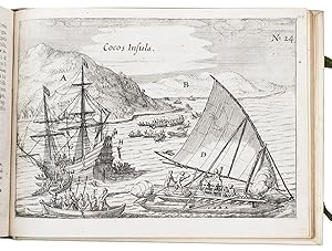
Untitled charts of the Pacific, New Guinea, and the Strait of Le Maire.
Verlag: apud Nicolaum ŕ Geelkercken,
Anbieter: Daniel Crouch Rare Books Ltd, London, Vereinigtes Königreich
Verbandsmitglied: ABA ILAB PBFA
Verkäuferbewertung 4 von 5 Sternen
Karte
EUR 1.669,61
EUR 23,16 Versand
Versand von Vereinigtes Königreich nach USAAnzahl: 1 verfügbar
In den Warenkorb"Fretum le Maire" Double-page engraved chart. A detailed chart of the route taken by Jacob Le Maire and Willem Schouten from Porto Desire across the Pacific to New Guinea, with insets of their route along the north coast of New Guinea, and through the strait that was named for him: "Fretum le Maire", to the south of Tierra del Fuego. Published in Joris van Spilbergen's 'Speculum orientalis occidentalisque Indiae navigationum' (1619). In 1614 the VOC enjoined Spilbergen to sail with six vessels to the Moluccas via the Straits of Magellan. The five-year circumnavigation was the first carried out with the official support of the Dutch government. Although officially a trading mission, Spilbergen was authorised by the VOC to use force to disrupt the Spanish Pacific trade (Allen). Once the Seventeen Provinces had freed themselves from Spanish rule in 1581, they no longer had access to the Habsburg trading empire and needed to establish their own presence in the Pacific. Spilbergen himself believed that "the best and only means of reestablishing our affairs in the Indies and of making ourselves entirely masters of the Moluccas is, in my opinion, to dispatch a fleet and armada direct to the Philippines, in order to attack the Spaniards there, and to overpower all the places and strongholds it may be possible to conquer" (Zaide). After various mutinies and even more numerous acts of piracy, Spilbergen sailed through the Straits, he and his fleet captured and occupied Acapulco for a week, and then commenced their voyage across the Pacific in November of 1615. En route they discovered many islands, eventually reaching the Ladrones or Mariana Islands, and finally the Philippines where they spent a month raiding Manila-bound shipping, and the Dutch East Indies. There Spilbergen met up with Le Maire, who had discovered a new passage to the Pacific and had explored the Tuamotou Archipelago. Le Maire's voyages gave decisive evidence against the supposed existence of a massive southern continent and formed a catalyst to Tasman's discovery of New Zealand and Australia. Jacob Le Maire and Cornelis Schouten's voyage from Texel in June 1615, was a mission to find a new route to reach the Spices Islands which would break the trade monopoly of the VOC (which had been grant a monopoly trade through the Strait of Magellan). The pair succeeded by rounding South America south of the Straits of Magellan. The new cape was name "Horn" (or "Hoorn") after Shouten's ship which had been lost due to fire at the Patagonian port Desire. In doing so they also dispelled the myth of a great southern continent joined to South America. Le Maire and Schouten would continue to sail across the Pacific, discovering numerous islands along the way, and sailing up the northern coast of New Guinea. By September 1616 Le Maire reached Ternate in the Moluccas, the headquarters of the VOC. Initially well received, they were soon accused of having encroached on the rights of the Company and were tried, found guilty and shipped home on Spilbergen's ship which was completing its own trip around the world. Le Maire died on the return voyage and his journals were taken by the Company. Schouten and Spibergen published an abbreviated version of the journals; but it was not until 1622, after a long trial, that Isaac Le Maire was able to regain custody of his son's journals and to publish them in full. Provenance: Freycinet family archives Allen, 'North American Exploration: A New World Disclosed', 1997; Suarez, 'Early Mapping of Southeast Asia', 1999, pages 202-204; Zaide, 'Philippine Political and Cultural History: The Philippines since pre- Spanish Times', 1957.
-
Speculum orientalis occidentalisque Indiae navigationum.
Anbieter: Douglas Stewart Fine Books, Armadale, VIC, Australien
Verkäuferbewertung 4 von 5 Sternen
Erstausgabe
EUR 22.039,15
EUR 32,11 Versand
Versand von Australien nach USAAnzahl: 1 verfügbar
In den WarenkorbLugduni Batavorum [i.e. Leiden] : Jodocus Hondius for Nicolaus van Geelkercken, 1619. Small oblong quarto (190 x 250 mm), contemporary limp vellum with early manuscript title and collection number to spine; title with large engraved vignette (early ownership signature to upper margin); pp. [4 blank], 175, [5 blank]; with a folding engraved world map and a further 24 engraved maps, plans and views (including 2 folding maps, 2 double-page maps, one folding view and one double-page view); one preliminary leaf chipped at fore-edge, a few of the plates browned, otherwise sound and clean throughout, a good example; housed in a custom clamshell box of half morocco over marbled papered boards and cloth, spine lettered and decorated in gilt. One of the most significant illustrated travel books of the early 1600s. Spilbergen and Le Maire's "The East and West IndianMirror", which combines two circumnavigation narratives, was first published in Leiden in 1619 in simultaneous Dutch and Latin editions. A second issue of each edition was printed in the same year.This is the first Latin edition, second issue (the same as the first issue in every respect but with the name of Hondius added to the imprint on the title). All of the 1619 editions, both Dutch and Latin, were issued with the same plates. In 1614 Joris van Spilbergen's Dutch East India Company flotilla, comprised of six ships, set out for the Moluccas with the intention of reaching the East Indies via the Strait of Magellan and crossing the Pacific from east to west. The expedition sailed first to Brazil, then through the Strait of Magellan and northwards along the coasts of Chile and Peru, as far as California. Its vessels were armed and carried out attacks on Spanish settlements and shipping en route. Spilbergen then sailed for the Philippines and on to Batavia, where he failed to locate a Spanish fleet rumoured to be planning attacks against Dutch interests in the Moluccas. Instead, he encountered Le Maire and Schouten, who had recently arrived from their Pacific crossing on behalf of the Compagnie Australe only to be arrested for breaching the VOC monopoly on the Strait of Magellan passage. Spilbergen was responsible for conducting Le Maire, Schouten and their men back to the Netherlands (although Le Maire died on the voyage). 'The Mirror is an extremely important book for the history of Dutch navigation' (Borba de Moraes). Howgego, S159; Landwehr, VOC, 361; Sabin, 89450; Alden & Landis, 619/133; Borba de Moraes, II:276.
-
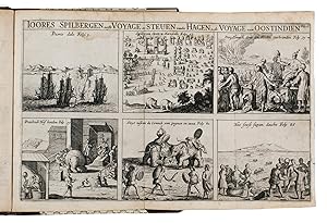
Historis journael van de voyages gedaen met 3 schepen uyt Zeelant naer d'Oost-Indien onder het beleyt van den Commandeur Joris van Spilbergen, sijn eerste reyse. Inden jare 1601, 1602, 1603, 1604, als meede beschryvinge vande tweede voyage ghedaen met 12 schepen na d'oost-Indien onder den Admirael Steven vander Hagen.
Verlag: Joost Hartgers,, Amsterdam,, 1648
Anbieter: ASHER Rare Books, T Goy Houten, Niederlande
Verkäuferbewertung 5 von 5 Sternen
EUR 4.000,00
EUR 25,00 Versand
Versand von Niederlande nach USAAnzahl: 1 verfügbar
In den WarenkorbAccount of the famous first voyage to the East Indies by the German naval officer in Dutch service, Joris van Spi(e)lbergen (1558-1620), first published in 1605. Appended are Potanus's description of Java (pp. 57-61) and, with its own drop-title, an account of Steven vander Hagen's second voyage to the East Indies (pp. 62-96), first published in 1606. The whole, also issued in Joost Hartgers collection Oost-Indische voyagien (1648), is based on the editions of Spilbergen (including Potanus's description) and Van der Hagen published in the 10th and 12th parts of Commelin's collection Begin ende voortgangh (1645).Funded by the entrepreneur Balthasar de Moucheron, Spilbergen left for the East Indies with three ships: Het Lam (the lamb), De Ram (the ram) and Het Schaap (the sheep). He sailed from Veere in Zeeland on 5 May 1601. In November he rounded the Cape of Good Hope to reach Ceylon (Sri Lanka) in May 1602. Until September the fleet was anchored at Batticaloa on Ceylon's east coast where Spilbergen negotiated with the king of Kandi, promising him military assistance against the Portuguese. Between September 1602 and March 1603 he was at Banda Atjeh, in Sumatra, negotiating with the sultan and hunting for Portuguese ships. In February 1603 ships of the newly founded Dutch East India Company (VOC) arrived at Atjeh and were joined by Spilbergen's fleet. After spending the summer of 1603 at Bantam in Java, Spilbergen returned to Holland with his two remaining ships, arriving at Vlissingen on 24 March 1604.In 1603 the VOC appointed Steven vander Hagen to lead a voyage to the East Indies, which sailed in December 1603 with twelve heavily armed vessels taking about 1200 men. His instructions were to attack the Portuguese trading ports in India, take Malacca, and expel the Spanish from the Moluccas. Also with Vander Hagen's fleet was the yacht Duyfken under command of Willem Jansz., who was to discover Australia in 1606. In September 1605 Vander Hagen sailed for Holland leaving the Duyfken and another vessel in the Indies for further exploration, and leaving three manned forts in the Spice Islands.The present 1648 edition appears to be the third separately published edition (after 1605 and 1617). No other separate editions are recorded so early in STCN, Picarta and WorldCat. The text was also published, however, as part of De Bry's Orientalischen Indien (1605/06) and Commelin's Begin ende voortgangh . (1646), which may account for other editions noted in the literature.With a bookbinder's gold-lettered black leather label on the back paste-down (BoekbinderBruns.nl). Slightly water stained in the head margin, slightly browned throughout and cut somewhat short in the foot margin, not affecting the text. Otherwise in good condition.l Alden & Landis 648/181 (5 copies); Howgego, to 1800, S158; Sabin 89448; STCN (5 copies); Tiele, Bibl. 1022 & 446 note; Tiele, Mém. 143 (for V.d. Hagen see also pp. 170-171); Landwehr & V.d. Krogt, VOC 198. Modern brown calf, decorated paper sides with a gold-lettered red morocco title-label on the gold-tooled spine, red sprinkled edges, modern endpapers. With a relatively large woodcut illustration of two ships on the title-page, a folding engraved plate showing six scenes of Spilbergen's journey and experiences in the East, a woodcut tail-piece, and 2 woodcut decorated initials. Set in textura types with incidental roman and italic. Pages: 96 pp.
-
Indiae Orientalis pars septima [.].Including: Icones, hoc est verae variorum populorum et regum, ceremoniarum item, superstitiosorum rituum et rerum aliarum, .
Verlag: Wolfgang Richter,, Frankfurt,, 1606
Anbieter: Antiquariaat FORUM BV, Houten, Niederlande
Verkäuferbewertung 5 von 5 Sternen
Erstausgabe
EUR 28.000,00
EUR 25,00 Versand
Versand von Niederlande nach USAAnzahl: 1 verfügbar
In den WarenkorbFirst edition of the Latin translation of book seven of Théodore de Bry's Petits voyages, the greatest single collection of material on early voyages to the East Indies, which is considered unique in its extraordinary wealth of cartographical and visual material. Crucially, this much-sought volume includes Gasparo Balbi's groundbreaking account of the Middle East, first published in 1590 as Viaggio dell' Indie Orientali - a mere 16 years before this present edition, making this the second appearance in print altogether and the first Latin translation. Balbi, a Venetian jewel merchant, travelled extensively in the Arabian Peninsula in search of precious stones. From Venice he sailed for Aleppo, proceeding to Bir and from there overland to Baghdad, descending the Tigris to Basra, where he embarked for India. While in the Persian Gulf, he studied the pearl industry, noting that the best pearls were to be found at Bahrain and Julfar. He refers to islands in the Emirate of Abu Dhabi (including Sir Bani Yas and Das) and to several coastal settlements that were to become permanently established, such as Dubai and Ras al Khaima. Balbi was the first to record the place names along the coast of modern Qatar, the United Arab Emirates and Oman. Practically "none of the names of places on the coast between Qatar and Ras al Khaima occur in other sources before the end of the eighteenth century" (Slot). The volume also comprises the account of Joris von Spilbergen's voyage to Ceylon in 1601-1604 (with excellent plates).A note with red pencil on the second leaf, browned, some small spots, otherwise in good condition.l Brunet I, col. 1334; cf. Carter, Sea of pearls, p. 79; Howgego, to 1800, B7; Slot, The Arabs of the Gulf, 1602-1784; United Arab Emirates yearbook 2006, p. 20. 20th-century half green morocco, title in gold on spine, marbled sides and endpapers. With the letterpress title within an engraved architectural border, an individual letterpress title-page for the Icones, an engraved coat of arms on the dedication leaf, 20 engravings in text and 2 double-page engraved plates. Pages: [4], 126, [2 blank] pp.; 26 ll.
-
Speculum Orientalis Occidentalisque Indiae Navigationum; quarum una Georgij Ă Spilbergen classis cum potestate Praefect, altera Jacobi le Maire auspicijs imperioque directa, Annis 1614, 15, 16, 17, 18.
Verlag: Leiden Nicolaes van Geelkercken, 1619
Anbieter: Shapero Rare Books, London, Vereinigtes Königreich
Verbandsmitglied: ABA ILAB PBFA
Verkäuferbewertung 5 von 5 Sternen
Erstausgabe
EUR 23.851,56
EUR 17,37 Versand
Versand von Vereinigtes Königreich nach USAAnzahl: 1 verfügbar
In den WarenkorbFirst Latin edition. Landscape 4to, large engraved view to title, 25 engraved plates of charts and views (including a large folding engraved world map and a similar map of the East Indies, along with 5 double-page plates); some occasional light spotting, very small paper repair to leading edge of title page, also to outer edge of plate 3, upper and lower edge of margin of final leaf of text, lower corner of penultimate leaf repaired. Contemporary limp vellum, recased with new endpapers, lettering on spine faded, some light soiling to covers, with contemporary ink marks. [vii], [i](blank), 9-175, [1](blank)pp. The first Latin edition of the first circumnavigation to have the official support of the Dutch government. A book of primary importance in the history of Dutch navigation, with descriptions of the Straits of Magellan, and (amongst others) Concepcion, Valparaiso, Callao and Acapulco, with engraved views of their harbours. Joris van Spilbergen (1568-1620) sailed from Texel in August 1614 with 800 men aboard six ships. Although his voyage was sponsored by the VOC, with a merchant aboard each ship, this was a privateering voyage. Landing first in Brazil, the fleet went on to sail through the Straits of Magellan and into the Pacific. Travelling up the coast of South America towards Acapulco, Spilbergen raided Spanish settlements along the way. He saw himself as taking the war for Dutch independence from the Spanish to a new theatre, one of his prizes being the pearl fishing vessel the San Francisco captured at Zacatula, just North of Acapulco Crossing the Pacific to the Mariana Islands and then Philippine Islands, Spilbergen continued to harass Spanish ships, netting a considerable amount of prize money before arriving in Batavia in September1616. Transferring to the Amsterdam for the voyage home via the Cape of Good Hope, Spilbergen was accompanied by Le Maire and Schouten who had been tried for infringing the VOC's monopoly. Le Maire subsequently died on the voyage home, and the others arrived in the Dutch Republic in July 1717. The plates for this edition, a translation of the Dutch 1617 edition, are the same as found in the Dutch editions. They include images of Concepcion, Valparaiso, Acapulco, Manila, and Amboyna. European Americana, 619/133; Sabin, 89450; Tiele, 66; Shirley, 304; Landwehr (VOC), 361.
-
Indiae Orientalis pars septima [.]. Including: Icones, hoc est verae variorum populorum et regum, ceremoniarum item, superstitiosorum rituum et rerum aliarum [.].
Verlag: Frankfurt, Wolfgang Richter, 1606., 1606
Anbieter: Antiquariat INLIBRIS Gilhofer Nfg. GmbH, Vienna, A, Österreich
Verbandsmitglied: ILAB PADA VDA VDAO
Verkäuferbewertung 5 von 5 Sternen
Erstausgabe
EUR 28.000,00
EUR 30,00 Versand
Versand von Österreich nach USAAnzahl: 1 verfügbar
In den WarenkorbFolio (325 × 200 mm). With the letterpress title within an engraved architectural border, an individual letterpress title-page for the Icones, an engraved coat of arms on the dedication leaf, 20 engravings in text and 2 double-page engraved plates. 20th-century green half morocco. First edition of the Latin translation of book seven of Théodore de Bry's Petits voyages, the greatest single collection of material on early voyages to the East Indies, which is considered unique in its extraordinary wealth of cartographical and visual material. Crucially, this much-sought volume includes Gasparo Balbi's groundbreaking account of the Middle East, first published in 1590 as Viaggio dell' Indie Orientali - a mere 16 years before this present issue, making this the second appearance in print altogether and the first Latin translation. Balbi, a Venetian jewel merchant, travelled extensively in the Arabian Peninsula in search of precious stones. From Venice he sailed for Aleppo, proceeding to Bir and from there overland to Baghdad, descending the Tigris to Basra, where he embarked for India. While in the Gulf, he studied the pearl industry, noting that the best pearls were to be found at Bahrain and Julfar. He refers to islands in the Emirate of Abu Dhabi (including Sir Bani Yas and Das) and to several coastal settlements that were to become permanently established, such as Dubai and Ras al Khaima. Balbi was the first to record the place names along the coast of modern Qatar, the United Arab Emirates and Oman. Practically "none of the names of places on the coast between Qatar and Ras al Khaima occur in other sources before the end of the eighteenth century" (Slot). The volume also comprises the account of Joris von Spilbergen's voyage to Ceylon in 1601-1604 (with excellent plates). - A note with red pencil on the second leaf, browned, some small spots, otherwise in good condition. - Brunet I, col. 1334. Cf. Carter, Sea of pearls, p. 79. Howgego, to 1800, B7. Slot, The Arabs of the Gulf, 1602-1784. United Arab Emirates yearbook 2006, p. 20.
-
Miroir Oost & West-Indical, auquel sont descriptes les deux dernieres navigations, faictes es années 1614. 1615. 1616. 1617. & 1618. l'une par le renommé guerrier de mer, George de Spilbergen, par le Destroict de Magellan, & ainsi tout autour de toute la terre, avec toutes les battailles données tant par terre que par eau. Icy sont aussi adioustées deux histoires, l'une des Indes Orientales, l'autre des Indes Occidentales, avec le nombre des navires, forts, soldats & artillerie. L'autre faicte par Jacob le Maire, lequel au costé du Zud du Destroict de Magellan, a decouvert un nouveau destroict. Avec la description de tous pays, gens & nations.
Verlag: Johannes Janssonius [printed by Izaak Elzevier?],, Amsterdam,, 1621
Anbieter: ASHER Rare Books, T Goy Houten, Niederlande
Verkäuferbewertung 5 von 5 Sternen
EUR 16.500,00
EUR 25,00 Versand
Versand von Niederlande nach USAAnzahl: 1 verfügbar
In den WarenkorbFirst and only edition of the French translation of one of the bestsellers of illustrated 17th-century travel literature, describing one of the most famous early voyages around the world by Joris van Spilbergen (1568-1620), a veteran Dutch East Indies naval officer-turned-pirate, undertaken from 1614 to 1618. A short survey of another of the most important early voyages around the world, by Schouten and Le Maire in the years 1615 to 1617, is added at the end (pp. 117-172) with drop-title "Navigationes Australes". It reports Le Maire's proof that Tierra del Fuego is an island and his discovery of what is still called the Strait of Le Maire, an alternative route to the Pacific. Rich in ethnographic detail, the numerous illustrations in the Miroir include oversized penguins, llamas and an Andean condor with a nine-foot wing span. Naval battles, beleaguered Spanish settlements, and newly discovered islands are also depicted in detail, making the work a valuable compendium of adventure on the high seas during the Age of Discovery.With several owner's inscriptions. With a few manuscript annotations in the margin. Lacking the world map. Washed with a brush, leaving light brown steaks on most leaves, and further with an occasional leaf foxed or smudged and an occasional minor tear. Otherwise a good copy of an extraordinary journal.l Borba de Moraes, p. 826 ("This French edition is much sought after"); Landwehr & V.d. Krogt, VOC 362; Sabin 89451; Tiele, Bibl. 1030. Modern vellum, sewn on 4 vellum tapes, with gold double fillets on the boards, gold lettering on the spine, gilt edges, green cloth ties. With 24 (of 25) engraved plates with maps, plans, views and battle-scenes, including 5 double-page and 10 larger folding (the large map of the Malayan archipelago with an inset-map of the Strait of Boeton, 32 x 45.5 cm). Pages: [4], 172 pp.


![Bild des Verkäufers für Speculum orientalis occidentalisque Indiae navigationum; quarum una Georgii a Spilbergen classis cum potestate praefecti, altera Iacobi le Maire auspiciis imperioque directa, annis 1614, 15, 16, 17, 18. Exhibens novi in mare australe transitus, incognitarumque hactenus terrarum ac gentium inventione[m], praelia aliquot terra marique commissa, expugnationesq[ue] urbium zum Verkauf von Bernard Quaritch Ltd ABA ILAB](https://pictures.abebooks.com/inventory/md/md31574719586.jpg)


![Bild des Verkäufers für Indiae Orientalis pars septima [.].Including: Icones, hoc est verae variorum populorum et regum, ceremoniarum item, superstitiosorum rituum et rerum aliarum, . zum Verkauf von Antiquariaat FORUM BV](https://pictures.abebooks.com/inventory/md/md30339589694.jpg)

![Bild des Verkäufers für Indiae Orientalis pars septima [.]. Including: Icones, hoc est verae variorum populorum et regum, ceremoniarum item, superstitiosorum rituum et rerum aliarum [.]. zum Verkauf von Antiquariat INLIBRIS Gilhofer Nfg. GmbH](https://pictures.abebooks.com/inventory/md/md30099721631.jpg)