Gesamtpreis (1 Artikel Artikel):
Versandziel:

speede john (21 Ergebnisse)
Direkt zu den wichtigsten Suchergebnissen
Suchfilter
Produktart
- Alle Product Types
- Bücher (13)
- Magazine & Zeitschriften (Keine weiteren Ergebnisse entsprechen dieser Verfeinerung)
- Comics (Keine weiteren Ergebnisse entsprechen dieser Verfeinerung)
- Noten (Keine weiteren Ergebnisse entsprechen dieser Verfeinerung)
- Kunst, Grafik & Poster (Keine weiteren Ergebnisse entsprechen dieser Verfeinerung)
- Fotografien (Keine weiteren Ergebnisse entsprechen dieser Verfeinerung)
- Karten (8)
- Manuskripte & Papierantiquitäten (Keine weiteren Ergebnisse entsprechen dieser Verfeinerung)
Zustand Mehr dazu
- Neu (Keine weiteren Ergebnisse entsprechen dieser Verfeinerung)
- Wie Neu, Sehr Gut oder Gut Bis Sehr Gut (2)
- Gut oder Befriedigend (13)
- Ausreichend oder Schlecht (Keine weiteren Ergebnisse entsprechen dieser Verfeinerung)
- Wie beschrieben (6)
Einband
Weitere Eigenschaften
- Erstausgabe (1)
- Signiert (Keine weiteren Ergebnisse entsprechen dieser Verfeinerung)
- Schutzumschlag (Keine weiteren Ergebnisse entsprechen dieser Verfeinerung)
- Angebotsfoto (17)
Sprache (2)
Gratisversand
Land des Verkäufers
Verkäuferbewertung
-

Old Map of Yorkshire 1610. An Antiqued Parchment Replica.
Verlag: Penzance: Old Map Company, 1991
Anbieter: Plurabelle Books Ltd, Cambridge, Vereinigtes Königreich
Verbandsmitglied: GIAQ
Verkäuferbewertung 5 von 5 Sternen

EUR 5,91
EUR 9,17 Versand
Versand von Vereinigtes Königreich nach USAAnzahl: 1 verfügbar
In den WarenkorbPaperback. Zustand: Very Good. Foldout antiqued parchment replica map in original red card pouch, light wear to cover, map excellent, as new Language: English.
-
Old Map of Essex 1610. An Antiqued Parchment Replica.
Verlag: Penzance: Old Map Company, 1991
Anbieter: Plurabelle Books Ltd, Cambridge, Vereinigtes Königreich
Verbandsmitglied: GIAQ
Verkäuferbewertung 5 von 5 Sternen
EUR 5,91
EUR 9,17 Versand
Versand von Vereinigtes Königreich nach USAAnzahl: 1 verfügbar
In den WarenkorbPaperback. Zustand: Very Good. Foldout antiqued parchment replica map in original red card pouch, light wear to cover, map excellent, as new Language: English.
-
Olde Map of Cornwall: An Antiqued Parchment Replica (The Olde Map Company)
Verlag: The Olde Map Company
Anbieter: Wonder Book, Frederick, MD, USA
Verkäuferbewertung 5 von 5 Sternen
Zustand: As New. Like New condition. Slipcase Very Good. (Cornwall, Great Britain, maps ) A near perfect copy that may have very minor cosmetic defects.
-

Map of the countie of Nottingham
Verlag: Unknown, 1985
Anbieter: Aucott & Thomas, Ibstock, Vereinigtes Königreich
Verkäuferbewertung 5 von 5 Sternen
Karte
EUR 11,34
EUR 17,20 Versand
Versand von Vereinigtes Königreich nach USAAnzahl: 1 verfügbar
In den WarenkorbMap. Zustand: Very Good. Reprint. Coloured reprint of John Speede's 1610 map. Map is 58.3 x 45.5cm, border is 3.5cm. No marks, chips or inscriptions. Undated but assume mid 1980s. Printed on very good quality cartridge paper, and will be sent in a cardboard tube to avoid postal damage.
-

Map of Suffolk(e)
Verlag: Unknown, 1985
Anbieter: Aucott & Thomas, Ibstock, Vereinigtes Königreich
Verkäuferbewertung 5 von 5 Sternen
Karte
EUR 11,34
EUR 17,20 Versand
Versand von Vereinigtes Königreich nach USAAnzahl: 1 verfügbar
In den WarenkorbMap. Zustand: Very Good. Reprint. Coloured reprint of John Speede's 1610 map. Map is 58.3 x 45.5cm, border is 3.5cm. Edge creased at bottom left corner, 2 small closed tears at bottom edge, no inscriptions. Undated but assume mid 1980s.
-

Map of Oxfordshire
Verlag: Unknown, 1985
Anbieter: Aucott & Thomas, Ibstock, Vereinigtes Königreich
Verkäuferbewertung 5 von 5 Sternen
Karte
EUR 11,34
EUR 17,20 Versand
Versand von Vereinigtes Königreich nach USAAnzahl: 1 verfügbar
In den WarenkorbMap. Zustand: Very Good. Reprint. Coloured reprint of John Speede's 1610 map. Map is 58.3 x 45.5cm, border is 3.5cm. Edge creased at bottom corners, 2 small closed tears on left edge & on bottom edge, no inscriptions. Undated but assume mid 1980s.
-

Map of Herefordshire
Verlag: Unknown, 1985
Anbieter: Aucott & Thomas, Ibstock, Vereinigtes Königreich
Verkäuferbewertung 5 von 5 Sternen
Karte
EUR 11,34
EUR 17,20 Versand
Versand von Vereinigtes Königreich nach USAAnzahl: 1 verfügbar
In den WarenkorbMap. Zustand: Very Good. Reprint. Coloured reprint of John Speede's 1610 map. Map is 58.3 x 45.5cm, border is 3.5cm. Lightly creased with short closed tear at top edge, no inscriptions. Undated but assume mid 1980s.
-

Map of Wilshire (Wiltshire)
Verlag: Unknown, 1985
Anbieter: Aucott & Thomas, Ibstock, Vereinigtes Königreich
Verkäuferbewertung 5 von 5 Sternen
Karte
EUR 11,34
EUR 17,20 Versand
Versand von Vereinigtes Königreich nach USAAnzahl: 1 verfügbar
In den WarenkorbMap. Zustand: Very Good. Reprint. Coloured reprint of John Speede's 1610 map. Map is 58.3 x 45.5cm, border is 3.5cm. No creases, chips or inscriptions. Undated but assume mid 1980s.
-

Map of Somerset-shire
Verlag: Unknown, 1985
Anbieter: Aucott & Thomas, Ibstock, Vereinigtes Königreich
Verkäuferbewertung 5 von 5 Sternen
Karte
EUR 11,34
EUR 17,20 Versand
Versand von Vereinigtes Königreich nach USAAnzahl: 1 verfügbar
In den WarenkorbMap. Zustand: Very Good. Reprint. Coloured reprint of John Speede's 1610 map. Map is 58.3 x 45.5cm, border is 3.5cm. Edges lightly creased and 2 small closed tears, one at each edge (will not show once framed), no inscriptions. Undated but assume mid 1980s. Printed on very good quality cartridge paper, and will be sent in a cardboard tube to avoid postal damage.
-

Map of Derbyshire (Darbieshire)
Verlag: Unknown, 1985
Anbieter: Aucott & Thomas, Ibstock, Vereinigtes Königreich
Verkäuferbewertung 5 von 5 Sternen
Karte
EUR 11,34
EUR 17,20 Versand
Versand von Vereinigtes Königreich nach USAAnzahl: 1 verfügbar
In den WarenkorbMap. Zustand: Very Good. Reprint. Coloured reprint of John Speede's 1610 map. Map is 58.3 x 45.5cm, border is 3.5cm. No marks, chips or inscriptions. Undated but assume mid 1980s. Printed on very good quality cartridge paper, and will be sent in a cardboard tube to avoid postal damage.
-
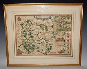
Old Map of Warwickshire 1610
Verlag: Porter Prints, York
Anbieter: Anvil Books, Prestatyn, FLINT, Vereinigtes Königreich
Verkäuferbewertung 5 von 5 Sternen
EUR 5,91
EUR 27,52 Versand
Versand von Vereinigtes Königreich nach USAAnzahl: 1 verfügbar
In den WarenkorbMap. Zustand: Fine. No Jacket. Rep. 20 x 15 inches, folded as issued in sl worn envelope. Authentic replica on antiqued parchment.
-
[THE ISLANDS.BRITISH ISLES].Holy Island, Farne, Guernsey, Jersey.]
Sprache: Englisch
Verlag: Henry Overton, London, 1610
Anbieter: David Wright Private Collection, Lowestoft, SUFFO, Vereinigtes Königreich
Verkäuferbewertung 4 von 5 Sternen

Erstausgabe
EUR 76,77
EUR 37,50 Versand
Versand von Vereinigtes Königreich nach USAAnzahl: 1 verfügbar
In den WarenkorbUnbound. Zustand: Near Very Good. No Jacket. J. Hondius (illustrator). First Edition. Holy Iland, Garnsey, Farne, Jarsey. Performed by John Speede and are to be solde by Henry Overton at the White Horse without Newgate, London. J. Hondius, 1610. An original map with contemporary hand colouring, divided into 4 quadrants each depicting a named island. narrow black Hogarth frame measuring 63.5 x51 cms. The engraved surface measures 51 x 38 cms. and has a narrow cream card mount allowing visible margins of 2 cms. There is the stain of an old sellotape repair 1.5 cms long at the extreme tail edge of the centre fold and there is possibly some fading to the colouring. Being framed, it is not possible to establish if the text on the verso is in latin. There is no Humble imprint in this issue. RARE.
-

The Kingdome of Irland - Divided into several Provinces, and the againe devided into Counties
Anbieter: Kennys Bookshop and Art Galleries Ltd., Galway, GY, Irland
Verkäuferbewertung 5 von 5 Sternen
Zustand: Very Good. . Hardback. "Extremely rare print. Few available. Reproduction of the famous John Speede map of Ireland from 1610. This was the earliest proper map of Ireland, and original copies are now scarce and very highly valued." Keywords: Posters - Ireland - Maps & Prints - Antique Maps. Not a first edition copy. . . .
-

The Kingdome of Irland - Divided into several Provinces, and the againe devided into Counties
Anbieter: Kennys Bookstore, Olney, MD, USA
Verkäuferbewertung 5 von 5 Sternen
Zustand: Very Good. . Hardback. "Extremely rare print. Few available. Reproduction of the famous John Speede map of Ireland from 1610. This was the earliest proper map of Ireland, and original copies are now scarce and very highly valued." Keywords: Posters - Ireland - Maps & Prints - Antique Maps. Not a first edition copy. . . . Books ship from the US and Ireland.
-
Northumberland - Published By Henry Overton
Sprache: Englisch
Verlag: Henry Overton, London, UK, 1710
Anbieter: Hornseys, Ripon, Vereinigtes Königreich
Verbandsmitglied: PBFA
Verkäuferbewertung 5 von 5 Sternen
EUR 584,61
EUR 28,67 Versand
Versand von Vereinigtes Königreich nach USAAnzahl: 1 verfügbar
In den WarenkorbNo Binding. Zustand: Very Good. Original copper-engraved map. Sheet size: 60.8cm x 48.7cm. Publishers show as Bassett and Chiswell but this is from an edition printed by Henry Overton in c.1710 or later. Blank to the verso as is found with the edition published by Henry Overton. Includes inset maps of Berwick and Newcastle. Good wide margins but with some age toning and browning which is mainly confined to the margins and the verso. Early hand-colouring. A scarce edition of John Speed's map of Northumberland and in very good condition overall.
-
?Miniature? Herefordshire. Original Antique Engraved Hand Coloured Miniature Map of Herefordshire.
Verlag: London, Sudbury & Humble, 1627, 1627
Anbieter: PROCTOR / THE ANTIQUE MAP & BOOKSHOP, DORCHESTER, Vereinigtes Königreich
Verbandsmitglied: PBFA
Verkäuferbewertung 5 von 5 Sternen
EUR 85,03
EUR 22,93 Versand
Versand von Vereinigtes Königreich nach USAAnzahl: 1 verfügbar
In den WarenkorbSo-called ?Miniature Speed.? Engraved surface approx 12 x 8 cm. Overall 15 x 9 cm. (approx 6 x 4 inches.) In very good condition. Nice bright colouring. Some minor darkening around edges. Bottom corner/edge of map is slightly clipped by page edge. Else an excellent clean and bright example. Original double-sided engraved map with later hand colouring, and part description of county on rear.
-
RUTLANDSHIRE With OUKHAM and STANFORD. Original Antique Engraved Hand Coloured Map of RUTLANDSHIRE. With, Arms of Nobles and County Crest. Plan of County Towns OUKHAM and STANFORD. Illustrations of Scribes to bottom corners.
Verlag: London, Sudbury & Humbell, 1620, 1620
Anbieter: PROCTOR / THE ANTIQUE MAP & BOOKSHOP, DORCHESTER, Vereinigtes Königreich
Verbandsmitglied: PBFA
Verkäuferbewertung 5 von 5 Sternen
EUR 389,74
EUR 22,93 Versand
Versand von Vereinigtes Königreich nach USAAnzahl: 1 verfügbar
In den WarenkorbPrinted area is approximately 50.6cms by 38.1cms. In very good condition. A minor crease on right hand margin, vertical center hold crease. Nice colouring. Some minor tanning, else A beautiful clean example. Ready to be Framed Original engraved map with hand colouring. A highly decorative 17th century map of Rutland, based on the survey by John Harrington, which was published in John Speed's Theatre of the Empire of Great Britaine (London: Sudbury & Humble, 1620s [No text]). The inset town plans of Stamford and Oakham, probably surveyed by Speed himself, are the earliest known of these places. This particular example comes from an unusual and undated atlas (probably 1620s).
-
Wight Island. First Edition of Speed's map of the Isle of Wight. Original Antique Engraved Hand Coloured Map of Wight Island. The Isle of Wight, with inset town plans of Southampton and Newport.
Verlag: London, Sudbury & Humbell, 1611-12, 1611
Anbieter: PROCTOR / THE ANTIQUE MAP & BOOKSHOP, DORCHESTER, Vereinigtes Königreich
Verbandsmitglied: PBFA
Verkäuferbewertung 5 von 5 Sternen
EUR 501,94
EUR 22,93 Versand
Versand von Vereinigtes Königreich nach USAAnzahl: 1 verfügbar
In den WarenkorbPrinted area is approximately 52cms by 39cms. Held in Ivory mount, with one gilt line border. In good condition. Two old tape strips lower left corner, slightly creased & small nick lower right corner. A few very faint small brown spots. Ready to be Framed Original engraved map with Uncoloured. This map was engraved by Jodocus Hondius and published in the first edition of John Speed's important atlas, 'The Theatre of the Empire of Great Britain'.
-
Herefordshire, Described with the true plot of the City Hereford. As Also the Armes of thos Nobles that have bene intitled with that Dignitye. Original Antique Engraved Hand Coloured Map of Herefordshire. With, Arms of Nobles and County Crest. Plan of County Town and illustration of the Battle between Pembroke and Ormond. Illustrations of Scribes to bottom corners.
Verlag: London, Sudbury & Humbell (Humble) 1611, 1611
Anbieter: PROCTOR / THE ANTIQUE MAP & BOOKSHOP, DORCHESTER, Vereinigtes Königreich
Verbandsmitglied: PBFA
Verkäuferbewertung 5 von 5 Sternen
EUR 513,75
EUR 22,93 Versand
Versand von Vereinigtes Königreich nach USAAnzahl: 1 verfügbar
In den WarenkorbFramed size approx 27 x 22 inches. Engraved surface approx 15 x 20 ins. Double-glazed (front and rear) in wood frame with grey mount. In very good condition. Nice bright colouring to crests and details. The outline colouring is more muted and give the map a lovely natural feel. One visible dark spot to lettering under crest ?William Fitz Osborne,? and also two minor spots to inset view of Hereford. Else an excellent clean and bright example. Original double-sided engraved map with later hand colouring, and description on rear.
-
Herefordshire, Described with the true plot of the City Hereford. As Also the Armes of thos Nobles that have bene intitled with that Dignitye. Original Antique Engraved Hand Coloured Map of Herefordshire. With, Arms of Nobles and County Crest. Plan of County Town and illustration of the Battle between Pembroke and Ormond. Illustrations of Scribes to bottom corners.
Verlag: London, Bassett and Chiswell 1676, 1676
Anbieter: PROCTOR / THE ANTIQUE MAP & BOOKSHOP, DORCHESTER, Vereinigtes Königreich
Verbandsmitglied: PBFA
Verkäuferbewertung 5 von 5 Sternen
EUR 519,66
EUR 22,93 Versand
Versand von Vereinigtes Königreich nach USAAnzahl: 1 verfügbar
In den WarenkorbFramed size approx 21 x 16 inches. Engraved surfaces approx 28 x 23.5 ins. Double-glazed in wood frame behind glass. (Front and Back.) In very good condition. Nice bright, colouring. Some minor darkening, a few small black mark lower left corner, else A beautiful clean example. Original engraved map with hand colouring.
-

A NEW MAPPE OF THE ROMANE EMPIRE
Verlag: London, 1626
Anbieter: Second Story Books, ABAA, Rockville, MD, USA
Verkäuferbewertung 4 von 5 Sternen
Karte
Original hand colored copper engraving. In Very Good condition in a Good frame. Exposed map measures w. 20 in. by h. 15.75 in. Frame measures w. 27.25 in. by h. 23 in. Matting and backing o frame non archival, minor foxing and agetoning to paper. Water damage to center of main textblock, text still legible. Minor fading to pigments, consistent with age. Not examined out of frame. Shelved at Rockville upstairs. This folio carte de figure map depicts the height of the Roman Empire as understood by cartographer John Speede. It shows the southern half of Europe (with Germania to the north), the British Isles, North Africa, the Middle East, etc. There are five figures engraved on either side, representing 17th century national stereotypes. City views of Rome, Genoa, Jerusalem, Venice, Constantinople and Alexandria line the top. 1398730. Arts & Antiques.

![Bild des Verkäufers für [THE ISLANDS.BRITISH ISLES].Holy Island, Farne, Guernsey, Jersey.] zum Verkauf von David Wright Private Collection](https://pictures.abebooks.com/inventory/md/md32345888420.jpg)