
Gesamtpreis (1 Artikel Artikel):
Versandziel:

sidney e morse (32 Ergebnisse)
Direkt zu den wichtigsten Suchergebnissen
Suchfilter
Produktart
- Alle Product Types
- Bücher (32)
- Magazine & Zeitschriften (Keine weiteren Ergebnisse entsprechen dieser Verfeinerung)
- Comics (Keine weiteren Ergebnisse entsprechen dieser Verfeinerung)
- Noten (Keine weiteren Ergebnisse entsprechen dieser Verfeinerung)
- Kunst, Grafik & Poster (Keine weiteren Ergebnisse entsprechen dieser Verfeinerung)
- Fotografien (Keine weiteren Ergebnisse entsprechen dieser Verfeinerung)
- Karten (Keine weiteren Ergebnisse entsprechen dieser Verfeinerung)
- Manuskripte & Papierantiquitäten (Keine weiteren Ergebnisse entsprechen dieser Verfeinerung)
Zustand Mehr dazu
Weitere Eigenschaften
- Erstausgabe (Keine weiteren Ergebnisse entsprechen dieser Verfeinerung)
- Signiert (Keine weiteren Ergebnisse entsprechen dieser Verfeinerung)
- Schutzumschlag (Keine weiteren Ergebnisse entsprechen dieser Verfeinerung)
- Angebotsfoto (20)
Sprache (2)
Gratisversand
Land des Verkäufers
Verkäuferbewertung
-

A new universal atlas of the world : on an improved plan ; consisting of thirty maps, carefully prepared from the latest authorities ; with complete alphabetical indexes.
Anbieter: PBShop.store US, Wood Dale, IL, USA
Verkäuferbewertung 5 von 5 Sternen

PAP. Zustand: New. New Book. Shipped from UK. Established seller since 2000.
-
A new universal atlas of the world : on an improved plan ; consisting of thirty maps, carefully prepared from the latest authorities ; with complete alphabetical indexes.
Anbieter: PBShop.store UK, Fairford, GLOS, Vereinigtes Königreich
Verkäuferbewertung 5 von 5 Sternen
EUR 17,57
EUR 3,82 Versand
Versand von Vereinigtes Königreich nach USAAnzahl: 15 verfügbar
In den WarenkorbPAP. Zustand: New. New Book. Shipped from UK. Established seller since 2000.
-
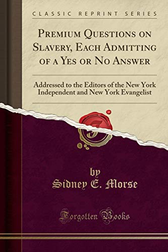
Premium Questions on Slavery, Each Admitting of a Yes or No Answer Addressed to the Editors of the New York Independent and New York Evangelist Classic Reprint
Anbieter: PBShop.store US, Wood Dale, IL, USA
Verkäuferbewertung 5 von 5 Sternen
PAP. Zustand: New. New Book. Shipped from UK. Established seller since 2000.
-
Premium Questions on Slavery, Each Admitting of a Yes or No Answer Addressed to the Editors of the New York Independent and New York Evangelist Classic Reprint
Anbieter: PBShop.store UK, Fairford, GLOS, Vereinigtes Königreich
Verkäuferbewertung 5 von 5 Sternen
EUR 24,15
EUR 3,82 Versand
Versand von Vereinigtes Königreich nach USAAnzahl: 15 verfügbar
In den WarenkorbPAP. Zustand: New. New Book. Shipped from UK. Established seller since 2000.
-

The Present Attempt to Dissolve the American Union: A British Aristocratic Plot
Anbieter: Ria Christie Collections, Uxbridge, Vereinigtes Königreich
Verkäuferbewertung 5 von 5 Sternen
EUR 15,65
EUR 13,91 Versand
Versand von Vereinigtes Königreich nach USAAnzahl: Mehr als 20 verfügbar
In den WarenkorbZustand: New. In.
-
Premium Questions on Slavery, Each Admitting Of a Yes or No Answer; Addressed to the Editors Of
Anbieter: Ria Christie Collections, Uxbridge, Vereinigtes Königreich
Verkäuferbewertung 5 von 5 Sternen
EUR 28,51
EUR 13,91 Versand
Versand von Vereinigtes Königreich nach USAAnzahl: Mehr als 20 verfügbar
In den WarenkorbZustand: New. In.
-

The Present Attempt to Dissolve the American Union: A British Aristocratic Plot
Anbieter: Ria Christie Collections, Uxbridge, Vereinigtes Königreich
Verkäuferbewertung 5 von 5 Sternen
EUR 30,25
EUR 13,91 Versand
Versand von Vereinigtes Königreich nach USAAnzahl: Mehr als 20 verfügbar
In den WarenkorbZustand: New. In.
-

EUR 22,11
EUR 48,99 Versand
Versand von Deutschland nach USAAnzahl: Mehr als 20 verfügbar
In den WarenkorbZustand: New.
-

System of Geography for the Use of Schools
Verlag: Harper & Brothers, 1850
Anbieter: A Squared Books (Don Dewhirst), South Lyon, MI, USA
Verkäuferbewertung 5 von 5 Sternen
Hardcover. Zustand: Fair. 1850; illustrated paper covered boards; wear and discoloration around edges; corners are scuffed and creased; spine is scuffed and heavily worn; 4to, 9 3/4"-12" tall; pages are speckled with discoloration; hinges are cracked; 72 pages. Photos available upon request. Additional shipping charges may need to be requested due to size or weight of book.
-

EUR 33,31
EUR 48,99 Versand
Versand von Deutschland nach USAAnzahl: Mehr als 20 verfügbar
In den WarenkorbZustand: New.
-

EUR 34,28
EUR 48,99 Versand
Versand von Deutschland nach USAAnzahl: Mehr als 20 verfügbar
In den WarenkorbGebunden. Zustand: New. KlappentextThis work has been selected by scholars as being culturally important, and is part of the knowledge base of civilization as we know it. This work was reproduced from the original artifact, and remains as true to the original w.
-

EUR 33,31
EUR 48,99 Versand
Versand von Deutschland nach USAAnzahl: Mehr als 20 verfügbar
In den WarenkorbGebunden. Zustand: New.
-

EUR 35,92
EUR 48,99 Versand
Versand von Deutschland nach USAAnzahl: Mehr als 20 verfügbar
In den WarenkorbGebunden. Zustand: New.
-

Premium Questions on Slavery, Each Admitting Of a Yes or No Answer; Addressed to the Editors Of
Sprache: Englisch
Verlag: Creative Media Partners, LLC Jul 2023, 2023
ISBN 10: 1022129295 ISBN 13: 9781022129290
Anbieter: AHA-BUCH GmbH, Einbeck, Deutschland
Verkäuferbewertung 5 von 5 Sternen
Taschenbuch. Zustand: Neu. Neuware.
-
![Bild des Verkäufers für A New Universal Atlas of the World, on an Improved Plan [cartographic Material]: Consisting of Thirty Maps, Carefully Prepared From the Latest Authori zum Verkauf von AHA-BUCH GmbH](https://pictures.abebooks.com/inventory/md/md31915244911.jpg)
A New Universal Atlas of the World, on an Improved Plan [cartographic Material]: Consisting of Thirty Maps, Carefully Prepared From the Latest Authori
Sprache: Englisch
Verlag: Creative Media Partners, LLC Sep 2021, 2021
ISBN 10: 1015319688 ISBN 13: 9781015319684
Anbieter: AHA-BUCH GmbH, Einbeck, Deutschland
Verkäuferbewertung 5 von 5 Sternen
Taschenbuch. Zustand: Neu. Neuware - This work has been selected by scholars as being culturally important and is part of the knowledge base of civilization as we know it.
-

A Geographical, Statistical and Ethical View of the American Slaveholders' Rebellion
Sprache: Englisch
Verlag: Creative Media Partners, LLC Mär 2019, 2019
ISBN 10: 0526611758 ISBN 13: 9780526611751
Anbieter: AHA-BUCH GmbH, Einbeck, Deutschland
Verkäuferbewertung 5 von 5 Sternen
Buch. Zustand: Neu. Neuware.
-

Premium Questions on Slavery, Each Admitting Of a Yes or No Answer; Addressed to the Editors Of
Sprache: Englisch
Verlag: Creative Media Partners, LLC Jul 2023, 2023
ISBN 10: 1020887834 ISBN 13: 9781020887833
Anbieter: AHA-BUCH GmbH, Einbeck, Deutschland
Verkäuferbewertung 5 von 5 Sternen
Buch. Zustand: Neu. Neuware - This powerful collection of questions addresses the issue of slavery head-on, offering a unique and thought-provoking perspective on a dark period in American history. It is essential reading for anyone interested in understanding the issues that have shaped our nation.
-
A System of Geography, for the Use of Schools. Illustrated with More Than Fifty Cerographic Maps, and Numerous Wood-Cut Engravings
Verlag: Harper Bros. New York, 1864
Anbieter: Antique Emporium, Eau Claire, WI, USA
Verkäuferbewertung 5 von 5 Sternen
Hardcover. Zustand: Good. 4to hardcover volume in pictorial paper boards. Spine and boards have some chipping but holding well. One reference library book plate and number on front cover. Contents good with some light scattered foxing. Saw part tear in Africa map. Texas is shown as a state.
-
Zustand: Hervorragend. Zustand: Hervorragend | Sprache: Englisch | Produktart: Bücher | Keine Beschreibung verfügbar.
-
A System of Geography, for the Use of Schools. Illustrated with More Than Fifty Cerographic Maps, and Numerous Wood-Cut Engravings
Verlag: Harper Bros. New York, 1846
Anbieter: Antique Emporium, Eau Claire, WI, USA
Verkäuferbewertung 5 von 5 Sternen
Hardcover. Zustand: Good. 3rd Edition. 4to hardcover volume in pictorial paper boards.Leather spine intact with a few chips to paper boards. Boards tight endpapers not marked. This is the 3rd printing of this geography 1st was in 1844. While Texas has become a state on the North America map it still shows as a republic. It is partly shown on the U.S. map and the individual map shows a very odd shape. The U.S. map also shows no Minnesota. Contents are complete with no tears but has foxing through out. The map of South America has part of a old victorian card stuck to it.
-
System of Geography, for the Use of Schools. Fifty Cerographic Maps, and Numerous Wood-Cut Engravings.
Verlag: Oublished by Harper & Brothers, New-York,, 1845
Anbieter: Bouquinerie du Varis, Russy, FR, Schweiz
Verkäuferbewertung 5 von 5 Sternen
paperback. 310x240mm, 72pages, Bande de ruban adhésif noir collé au dos. Envois Europe : Sans frais additionnels. TVA prélevée via IOSS & Envoi en DDP (droits payés). Exceptions (taxes postales locales ŕ la charge de l'acheteur) : France, Italie, Lituanie (~2EUR). Contact via notre page d'accueil en cas de problčme.
-

A Map of Ohio and Indiana from "An Atlas of the United States, on an Improved Plan;." with a complete index
Verlag: N. & S.S. Jocelyn, New Haven, 1823
Anbieter: Antipodean Books, Maps & Prints, ABAA, Garrison, NY, USA
Verbandsmitglied: ABAA ANZAAB ESA ILAB
Verkäuferbewertung 4 von 5 Sternen

Maps. Zustand: Good + overall. This map is one of the 11 published in Sidney E. Morse's atlas. Morse [1794 -- 1871] was an American inventor, geographer, journalist and brother of the telegraph pioneer Samuel F. B. Morse. 10 x 8", original outline color, trimmed close, evenly toned with index tipped onto card, one notatio at bottom edge, sunned due to being previously framed.
-

A Map of Virginia, Maryland and Delaware from "An Atlas of the United States, on an Improved Plan;." with a complete index
Verlag: N. & S. S. Jocelyn, New Haven, 1823
Anbieter: Antipodean Books, Maps & Prints, ABAA, Garrison, NY, USA
Verbandsmitglied: ABAA ANZAAB ESA ILAB
Verkäuferbewertung 4 von 5 Sternen
Maps. Zustand: Good + overall. This map is one of the 11 published in Sidney E. Morse's atlas. Morse [1794 -- 1871] was an American inventor, geographer, journalist and brother of the telegraph pioneer Samuel F. B. Morse. Two circular insets of District of Columbia and Baltimore. 10 x 8", original outline color, trimmed close, sunned due to being previously framed, evenly toned with index tipped onto card with an intentional fold at center to accommodate size.
-

A Map of Alabama, Mississippi and Louisiana from "An Atlas of the United States, on an Improved Plan;." with a complete index
Verlag: N. & S.S. Jocelyn, New Haven, 1823
Anbieter: Antipodean Books, Maps & Prints, ABAA, Garrison, NY, USA
Verbandsmitglied: ABAA ANZAAB ESA ILAB
Verkäuferbewertung 4 von 5 Sternen
Maps. Zustand: Good + overall. This map is one of the 11 published in Sidney E. Morse's atlas. Morse [1794 -- 1871] was an American inventor, geographer, journalist and brother of the telegraph pioneer Samuel F. B. Morse. 10 x 8", original outline color, trimmed close, evenly toned with index tipped onto card with rust marks at edges not affecting index, sunned due to being previously framed.
-
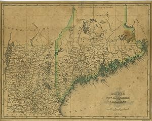
A Map of Maine, New Hampshire and Vermont from "An Atlas of the United States, on an Improved Plan;." with a complete index
Verlag: N. & S.S. Jocelyn, New Haven, 1823
Anbieter: Antipodean Books, Maps & Prints, ABAA, Garrison, NY, USA
Verbandsmitglied: ABAA ANZAAB ESA ILAB
Verkäuferbewertung 4 von 5 Sternen
Maps. Zustand: Good + overall. This map is one of the 11 published in Sidney E. Morse's atlas. Morse [1794 -- 1871] was an American inventor, geographer, journalist and brother of the telegraph pioneer Samuel F. B. Morse. 10 x 8", original outline color, trimmed close, evenly toned with index tipped onto card, sunned due to being previously framed, ruffled at top edge.
-
The Cerographic Missionary Atlas.
Verlag: New York: Sidney E. Morse, [1848]., 1848
Anbieter: Arader Galleries - AraderNYC, New York, NY, USA
Verkäuferbewertung 5 von 5 Sternen
Soft cover. Zustand: Fine. Oblong 4to., (12 x 13 inches). 18 maps engraved (on wax) maps (spotted, that of Western India with a large tear crossing the image with loss, stitching loose). Original brown printed paper wrappers; preserved in a modern brown cloth slipcase and chemise. With full-page maps showing missionary settlements throughout America and the world: including two global hemispheres showing North and South America in one and Africa, Europe and Australia in the other; "Indian Territory" showing Nebraska, Minnesota, Wisconsin, Iowa, Missouri, Arkansas, and Texas in addition to Indian Territories; Greenland and Labrador; part of Asia Minor; part of Syria; Palestine; the Country of the Nestorians; Northern India; Western India; Southern India; Bengal; Siam; China; West Africa (two); South Africa; and the Hawaiian Islands. Son of the celebrated Jedediah Morse, Sidney "was helpful to his father in revising the famous "Geography" of the elder Morse, and in 1822 the two edited a New System of Modern Geography. He made further advances in the field of geography when, in the 1830's, he and Henry A. Munson began working on a new method of printing maps: an engraving was made on wax, and from the engraving was made a plate to be inserted with the type. Morse had written atlases previously, the first being "An Atlas of the United States" in 1823, and the new method proved very valuable in enabling him to print several more. The first production using the new method was his "Gerographic Atlas of the United States", published in 1842. He is credited with two other inventions. On October 3, 1817, he and his brother Samuel F. B. Morse (1791-1872) were granted a patent for a "flexible piston pump", and on July 17, 1866, he and his son were granted one for a "bathometer", to be used in deep-sea exploration" (Yale University Library online). Catalogued by Kate Hunter.
-
A New Universal Atlas of the World, on an improved plan; consisting of thirty maps, carefully prepared from the latest authorities,.
Verlag: New -Haven: N & S.S. Jocelyn, 1825., 1825
Anbieter: Arader Galleries - AraderNYC, New York, NY, USA
Verkäuferbewertung 5 von 5 Sternen
Hardcover. Zustand: Very Good. 4to., (11 x 8 6/8 inches). Full-page engraved double-page map of the world, double-page map of the United States, and 28 full-page maps of America and the world, all with original hand-colour in outline (some spotting and browning). Original half red morocco, marbled paper boards, printed paper label on the front cover (worn). Second edition, first published in 1822. The map of the United States, engraved by Annin & Smith, is similar to the one engraved by N. & S.S. Jocelyn and published in Morse's "Atlas of the United States" (1823) and is cited by Wheat. The map features the Oregon country with the overly-long Multnomah (Willamette) River. There is no northern boundary shown, although it appears that the U.S. extends into present-day British Columbia. In the west, which is mostly labeled Unexplored Country, a dotted line connects a lake in the vicinity of Salt Lake to the Pacific accompanied by a note, "Supposed River between the Buenaventara and the Bay of Francisco which will probably be the communication between the Atlantic and the Pacific." Additional maps with American interest include: North America; Canada; Maine, New Hampshire and Vermont; Massachusetts, Rhode-Island and Connecticut; New York; Pennsylvania and New Jersey; Virginia, Maryland and Delaware; North Carolina, South Carolina and Georgia; Alabama, Mississippi and Louisiana; Kentucky and Tennessee; Ohio and Indiana; Illinois and Missouri; West Indies; South America. Australia is depicted in the Pacific Ocean. Son of the celebrated Jedediah Morse, Sidney "was helpful to his father in revising the famous "Geography" of the elder Morse, and in 1822 the two edited a New System of Modern Geography. He made further advances in the field of geography when, in the 1830's, he and Henry A. Munson began working on a new method of printing maps: an engraving was made on wax, and from the engraving was made a plate to be inserted with the type. Morse had written atlases previously, the first being "An Atlas of the United States" in 1823, and the new method proved very valuable in enabling him to print several more. The first production using the new method was his "Cerographic Atlas of the United States", published in 1842. He is credited with two other inventions. On October 3, 1817, he and his brother Samuel F. B. Morse (1791-1872) were granted a patent for a "flexible piston pump", and on July 17, 1866, he and his son were granted one for a "bathometer", to be used in deep-sea exploration" (Yale University Library online). Phillips 746; Ref: cf Wheat [TMW] #355. Catalogued by Kate Hunter.
-
A Map of New York from "An Atlas of the United States, on an Improved Plan;." with a complete index
Verlag: N. & S.S. Jocelyn, New Haven, 1823
Anbieter: Antipodean Books, Maps & Prints, ABAA, Garrison, NY, USA
Verbandsmitglied: ABAA ANZAAB ESA ILAB
Verkäuferbewertung 4 von 5 Sternen
Maps. Zustand: Good + overall. This map is one of the 11 published in Sidney E. Morse's atlas. Morse [1794 -- 1871] was an American inventor, geographer, journalist and brother of the telegraph pioneer Samuel F. B. Morse. 10 x 8", original outline color, trimmed close, evenly toned, sunned due to being previously framed. Includes paper index previously tipped onto card with several closed tears at top and left margin.
-

A Map of Kentucky and Tennessee from "An Atlas of the United States, on an Improved Plan;." with a complete index
Verlag: N. & S.S. Jocelyn, New Haven, 1823
Anbieter: Antipodean Books, Maps & Prints, ABAA, Garrison, NY, USA
Verbandsmitglied: ABAA ANZAAB ESA ILAB
Verkäuferbewertung 4 von 5 Sternen
Maps. Zustand: Good + overall. This map is one of the 11 published in Sidney E. Morse's atlas. Morse [1794 -- 1871] was an American inventor, geographer, journalist and brother of the telegraph pioneer Samuel F. B. Morse. 10 x 8", original outline color, trimmed close, evenly toned with index tipped onto card, sunned due to being previously framed.


