Gesamtpreis (1 Artikel Artikel):
Versandziel:

seutter matthias (115 Ergebnisse)
Direkt zu den wichtigsten Suchergebnissen
Suchfilter
Produktart
- Alle Product Types
- Bücher (102)
- Magazine & Zeitschriften (Keine weiteren Ergebnisse entsprechen dieser Verfeinerung)
- Comics (Keine weiteren Ergebnisse entsprechen dieser Verfeinerung)
- Noten (Keine weiteren Ergebnisse entsprechen dieser Verfeinerung)
- Kunst, Grafik & Poster (4)
- Fotografien (Keine weiteren Ergebnisse entsprechen dieser Verfeinerung)
- Karten (9)
- Manuskripte & Papierantiquitäten (Keine weiteren Ergebnisse entsprechen dieser Verfeinerung)
Zustand Mehr dazu
- Neu (Keine weiteren Ergebnisse entsprechen dieser Verfeinerung)
- Wie Neu, Sehr Gut oder Gut Bis Sehr Gut (2)
- Gut oder Befriedigend (5)
- Ausreichend oder Schlecht (Keine weiteren Ergebnisse entsprechen dieser Verfeinerung)
- Wie beschrieben (108)
Einband
- alle Einbände
- Hardcover (3)
- Softcover (Keine weiteren Ergebnisse entsprechen dieser Verfeinerung)
Weitere Eigenschaften
- Erstausgabe (2)
- Signiert (2)
- Schutzumschlag (Keine weiteren Ergebnisse entsprechen dieser Verfeinerung)
- Angebotsfoto (113)
Sprache (3)
Gratisversand
Land des Verkäufers
Verkäuferbewertung
-

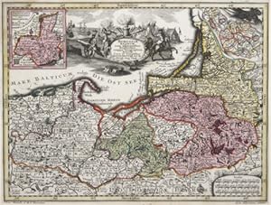
Mappa Geographica, continens Archiepiscopatum et Electoratum Coloniensem Cum Conterminis Ducatibus Iuliacensi Et Montensi nec non Comitatu Mursano. Kupferstich-Karte mit Flächenkolorit. Oben rechts Titelkartusche (nicht koloriert) mit 4 Wappen, unten links mit Meilenanzeiger.
Verlag: (Augsburg), 1750
Anbieter: Antiquariat am St. Vith, Mönchengladbach, Deutschland
Verkäuferbewertung 5 von 5 Sternen

Hardcover. 50 x 58 cm. (ca. 1750). gerollt, oben in den äußersten Ecken mit jeweils einem ca. 2 cm großen Fleck, sonst nur minimal stockfleckig.
-
Martis Area et Alea per tractum Rheni, Mosellae ac Mosae
Verlag: c. 1740, 1740
Anbieter: Attic Books (ABAC, ILAB), London, ON, Kanada
Verkäuferbewertung 5 von 5 Sternen
Karte
Zustand: Very good +. Approx 60 cm map on backerboard wrapped in mylar. Handcoloured later. Horizontal crease. A coloured, engraved map of the Rhine, Moselle and Meuse rivers with two decorative cartouches. Inset shows the Upper Rhine or source of the Rhine.
-
![Bild des Verkäufers für [Portfolio]: Antique Maps of the World in Color zum Verkauf von Between the Covers-Rare Books, Inc. ABAA](https://pictures.abebooks.com/inventory/md/md31614799540.jpg)
[Portfolio]: Antique Maps of the World in Color
Verlag: Sterling Publishing House, Co., Inc, New York, 1960
Anbieter: Between the Covers-Rare Books, Inc. ABAA, Gloucester City, NJ, USA
Verbandsmitglied: ABAA ESA ILAB IOBA
Verkäuferbewertung 5 von 5 Sternen
Erstausgabe
Unbound. Zustand: Very Good. Portfolio. Color facsimiles of 36 historical maps. Each map measures approximately 12" x 9", printed on 17" x 11˝" paper with descriptive text in the left margin. Housed with a title page sheet and unprinted top sheet in a four-fold chemise. Unprinted topsheet sunned at the edges, first two leaves with some very light toning and a couple of tiny corner creases; the maps are otherwise bright and fine. The chemise is good only with toning, wear, and soil, and a 1" creased tear on the cover panel. A nice production, and the chemise has done its job, keeping the maps bright and fresh.
-
![Bild des Verkäufers für Maiestas Austriaca sive Circulo Archiducato Austriae cum ceteris Augustissimae huic Domui per Germaniam continuo ferme tractu devotis Haereditariis Terris ob oculos posit. [Österreich anno 1750]. Landkarten- Faksimile in alter Farbkolorierung. zum Verkauf von Galerie Antiquariat Schlegl](https://pictures.abebooks.com/inventory/md/md19510946842.jpg)
Maiestas Austriaca sive Circulo Archiducato Austriae cum ceteris Augustissimae huic Domui per Germaniam continuo ferme tractu devotis Haereditariis Terris ob oculos posit. [Österreich anno 1750]. Landkarten- Faksimile in alter Farbkolorierung.
Sprache: Deutsch
Verlag: Erschienen in Fellbach bei Novo Print ohne Jahre Angabe [1980]., 1980
Anbieter: Galerie Antiquariat Schlegl, Weiden i. d. OPf., Deutschland
Verkäuferbewertung 3 von 5 Sternen

Karte
Schöner Faksimile- Nachdruck einer Kupferstich-Karte von Seutter aus Augsburg, um 1750, in alter Kolorierung, links oben Kartusche mit Länderwappen. Zustand: Guter, kräftiger Abdruck, leichte Bräunung, sonst sauber und tadellos erhalten. Sprache: Deutsch Gewicht in Gramm: 1050 Blatt- Größe 44 bis 50 cm; Gesamt- Größe 60 x 66,8 cm, unter chamois Schrägschnitt- Passepartout und in schützender Folie eingeschweißt. Nachdruck mit freundlicher Genehmigung der Württembergischen Landesbibliothek.
-
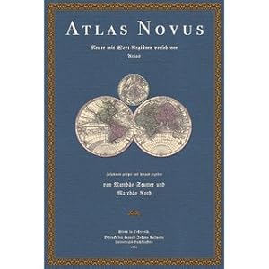
Atlas Novus Indicibus Instructus oder Neuer mit Wort-Registern versehener Atlas Bestehend in 50 Seutterisch-Geographischen Haupt- und Special-Tabellen
Sprache: Deutsch
Verlag: Fines Mundi GmbH Saarbrücken, 2021
Anbieter: Versandantiquariat Nussbaum, Bernkastel-Kues, RP, Deutschland
Verkäuferbewertung 5 von 5 Sternen
Zustand: Wie neu. Faksimile-Reprint der Ausgabe Wien 1736. XIV Seiten 2 farbige Titelblätter 53 doppelblattgroße Karten tadellos neuwertig / Als worüber erstlich ein sehr nutzlich-compendioser General- nachgehends aber über eine jede insonderheit ein solch-bequemer Special-Index gedrucket worden Daß mittelst desselben ein jedwederes, in der darzu gehörigen Mappa gestochenes Ort, und Wort ohne besondere Mühe alsogleich gefunden werden kan. Zusammen gesetzt, und zu bequemen Gebrauch deren Liebhabern der Geographischen Wissenschaft mit allergnädigster Kayserl. specialen Freyheit in offenen Druck heraus gegeben von Matthaeo Roth, Kayserl. Hof-Kriegs-Agenten 20 % verkleinerte Ausgabe Sprache: Deutsch Gewicht in Gramm: 2900 44,3 x 30,5 cm, gebundene Ausgabe.
-
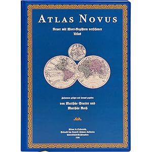
Atlas Novus
Verlag: Wien, 2021
Anbieter: Antiquariat Fines Mundi, Saarbruecken, Deutschland
Verkäuferbewertung 5 von 5 Sternen
-XIV Seiten-2 farbige Titelblätter-53 doppelblattgroße Karten --- Matthias Seutter und Matthias Roth:Atlas Novussive tabulae geographicae totius orbis faciem, partes, imperia, regna et provincias exhibentes, exactissima cura iuxta recentissimas observation aeri incisae et venum expositaea Matthaeo Seutter, sac. Caes. Majest Geogr. Augustae Vindelicorum Atlas Novus Indicibus Instructus, oderNeuer mit Wort-Registern versehener AtlasBestehend in 50 Seutterisch-Geographischen Haupt- und Special-TabellenAls worüber erstlich ein sehr nutzlich-compendioser General- nachgehends aber über eine jede insonderheit ein solch-bequemer Special-Index gedrucket wordenDaß mittelst desselben ein jedwederes, in der darzu gehörigen Mappa gestochenes Ort, und Wort ohne besondere Mühe alsogleich gefunden werden kan.Zusammen gesetzt, und zu bequemen Gebrauch deren Liebhabern der Geographischen Wissenschaft mit allergnädigster Kayserl. specialen Freyheit in offenen Druck heraus gegeben von Matthaeo Roth, Kayserl. Hof-Kriegs-Agenten20 % verkleinerte Ausgabe Verlagsfrischer, bibliophil ausgestatteter Faksimile-Reprint:Gedruckt auf einem schönen alterungsbeständigen und säurefreien Werkdruckpapier, das den Originaleindruck am besten wiedergibt.Gebunden als robuste Bibliotheksversion in Ganzleinen mit Rückenprägung.Bibliophil ausgestattet mit rundem Rücken und Lesebändchen.Ein dem Stil der Zeit entsprechender Umschlag wurde auf dem Vorderdeckel aufgezogen. --- 44,3 x 30,5 cm.
-
Africae magna pars ad illustrationem Historiae Ecclesiaticae (Algerien, Marokko, Tunesien).
Verlag: Matthäus Seutter, Augsburg, 1720
Anbieter: Antiquariat Hieronymus, München, Deutschland
Verkäuferbewertung 5 von 5 Sternen
Karte
Zustand: Gut. Gut. Kupferstich, altkoloriert. Blattgröße: 53,5 x 63 cm, Druckspiegel: 50 x 57,5 cm . Altkolorierter, kräftiger und klarer Druck auf etwas gebräuntem Papier, insgesamt gut erhalten. Sehr schöne und seltene Landkarte der Region des Mittelmeers mit Nordafrika (Algerien, Marokko und Tunesien) sowie Spanien, Südfrankreich, Italien und den Mittelmeerinseln der Balearen, Sardinien, Korsika und Sizilien. Herrliche Titelkartusche mit den allegorischen Figuren einer rechtgläubigen Europäerin und eines noch im Dunkeln lebenden Muslimen sowie dem darüber schwebenden Engel des Glaubens, der Christianisierung. Daneben zwei Tafeln mit beschreibendem Text in Latein und Deutsch. Landkarte, map, carte géographique, carta geografica, Mediterranean Sea, North-Africa, Maghreb, Maghrib, Algeria, Marocco, Tunisia, Spain, Italy, France, Sicily, Africa, Afrique, Algérie, Maroc, Tunisie. 1800 Gramm.
-

Atlas Novus - Halblederausgabe
Verlag: Wien, 2021
Anbieter: Antiquariat Fines Mundi, Saarbruecken, Deutschland
Verkäuferbewertung 5 von 5 Sternen
-XIV Seiten-2 farbige Titelblätter-53 doppelblattgroße Karten --- Matthias Seutter und Matthias Roth:Atlas Novussive tabulae geographicae totius orbis faciem, partes, imperia, regna et provincias exhibentes, exactissima cura iuxta recentissimas observation aeri incisae et venum expositaea Matthaeo Seutter, sac. Caes. Majest Geogr. Augustae Vindelicorum Atlas Novus Indicibus Instructus, oderNeuer mit Wort-Registern versehener AtlasBestehend in 50 Seutterisch-Geographischen Haupt- und Special-TabellenAls worüber erstlich ein sehr nutzlich-compendioser General- nachgehends aber über eine jede insonderheit ein solch-bequemer Special-Index gedrucket wordenDaß mittelst desselben ein jedwederes, in der darzu gehörigen Mappa gestochenes Ort, und Wort ohne besondere Mühe alsogleich gefunden werden kan.Zusammen gesetzt, und zu bequemen Gebrauch deren Liebhabern der Geographischen Wissenschaft mit allergnädigster Kayserl. specialen Freyheit in offenen Druck heraus gegeben von Matthaeo Roth, Kayserl. Hof-Kriegs-Agenten20 % verkleinerte Ausgabe Verlagsfrischer, bibliophil ausgestatteter Faksimile-Reprint:Gedruckt auf einem schönen alterungsbeständigen und säurefreien Werkdruckpapier, das den Originaleindruck am besten wiedergibt.Hier vorliegend die auf 300 Exemplare limitierte Luxusedition in Halbleder mit unechten Bünden.Der Überzug wurde aus einem historischen Kleisterpapier hergestellt.Auf dem vorderen Umschlag ist eine dekorative Vignette aufgebracht.Diese Ausgabe wird nur auf Bestellung hergestellt, die Lieferzeit beträgt etwa 3 Wochen. --- 44,3 x 30,5 cm.
-
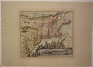
Recens edita totius Novi Belgii in America Septentrionali siti delineatio cura et sumtibus Matthaei Seutteri. Sac. Caes. Maj. Geographi August. Vind.
Verlag: Ediz. P.V., (o.J.).
Anbieter: Biblion Antiquariat, Zürich, ZH, Schweiz
Verbandsmitglied: GIAQ ILAB VEBUKU
Verkäuferbewertung 5 von 5 Sternen
21,5x25 cm. Kolorierte Karte. Unter Passepartout. Reprint der 4. Ausgabe von Seutters Karte, basierend auf Janssons Karte von 1651, Die "Restitutio View" mit einer neuen Ansicht von New York "Neu Jorck sive Neu Amsterdam" ersetzt und den zwei Textzeilen "Sac. Caes. .", Boston noch unkorrigiert mit Briston angegeben. Unten rechts "Ediz. P.V. - Die Karte ist verziert mit wilden Tieren und einer Szene mit Ureinwohnern, die dem Englischen König George II Tribute entgegenbringen. - (Kleiner Einriss im rechten Rand ausserhalb der Platte).
-
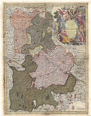
Circulus Bavariae
Verlag: Artist: Seutter Matthias ( - 1757 ) Augsburg; issued in: Augsburg; ca: 1720, 1678
Anbieter: Antique Sommer& Sapunaru KG, München, Deutschland
Verkäuferbewertung 3 von 5 Sternen
Technic: Copper print, colorit: original colored, condition: Mounted, size (in cm): 26 x 19,5 cm, Map shows Bavaria with a beautiful cartouche. From pocket atlas.
-
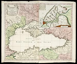
Nova Mappa Maris Nigri et Freti Constantinopolitani.
Verlag: Augsburg,, 1741
Anbieter: EOS Buchantiquariat Benz, Zürich, Schweiz
Verkäuferbewertung 5 von 5 Sternen
Kunst / Grafik / Poster
Altkolorierter Kupferstich. Blattgrösse: 49.4 x 57.8 cm Zeigt das Schwarze Meer mit der Krim und Bosporus. Mit Ausschnitt vom Borporus mit Istanbul / Konstantinopel. Dekorative Karte von Matthäus Seutter, deutscher Verleger, Kartograph und Kupferstecher aus Augsburg. - Die in der Mitte gefaltete Karte mit Gebrauchsspuren und kleinen Einrissen an den Rändern. + Wichtig: Für unsere Kunden in der EU erfolgt der Versand alle 14 Tage verzollt ab Deutschland / Postbank-Konto in Deutschland vorhanden +.
-

Silesiae Ducatus tam super. Quam inferior.
Verlag: Artist: Seutter Matthias ( - 1757 ) Augsburg; issued in: Augsburg; ca: 1744, 1678
Anbieter: Antique Sommer& Sapunaru KG, München, Deutschland
Verkäuferbewertung 4 von 5 Sternen

Technic: Copper print, colorit: original colored, condition: Perfect condition, size (in cm): 20 x 26 cm, Map shows the whole of Silesia with 2 splendid cartouches. from Atlas Minor.
-

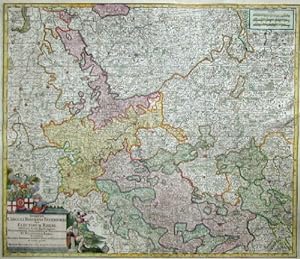
Archiepiscopat. et Electoratus Moguntinus, ut et Comitatus Uterq. Catimelibocens. Wertheimens. Erpacens. accuratine delin.
Verlag: Artist: Seutter Matthias ( - 1757 ) Augsburg; issued in: Augsburg; ca: 1728, 1678
Anbieter: Antique Sommer& Sapunaru KG, München, Deutschland
Verkäuferbewertung 3 von 5 Sternen
Technic: Copper print, colorit: original colored, condition: Perfect condition, size (in cm): 19,5 x 25,5 cm, Map shows the course of the Rhine from Koblenz to Speyer with the cities of Mainz (in Rhineland-Palatinate), Darmstadt (in Hesse), Heidelberg and Wertheim (in Baden-Württemberg). There is also a title cartouche with the coat of arms of the Mainz diocese, the god of wine (Bacchus), the goddess of the hunt (Diana), Hermes, Ares and a mileage cartouche.
-
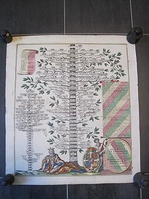
Neu inventierter genealogischer Stamm Baum aller Könige in Dänemarck von Anfang dieses Reichs bis auf Heut zu Tag glücklichst Regierende Königliche Majestat Fridericum IV. Altkolorierter Kupferstich von M. Seutter.
Verlag: Augsburg ca, 1750
Anbieter: Antiquariat Schleifer, Kobersdorf, BGLD, Österreich
Verkäuferbewertung 5 von 5 Sternen
Kunst / Grafik / Poster
Motiv: 55 x 48 cm; Blatt: 62,5 x 55 cm gedruckt auf dickerem Papier Ränder etwas knittrig, eine kleine hinterlegte Stelle im Mittelbug, schwacher Wasserfleck oben mittig, wurde zuerst gefaltet, dann gerollt gelagert. Insgesamt guter zeitgemäßer Zustand Sprache: Deutsch 2001 gr.
-
"Recens Elaborata Mappa Geographica Regni Brasiliae in America Meridionali Maxime Celebris Accuaratae Delineata".
Verlag: Matthaeus Seutter in Augsburg, 1730
Anbieter: George Jeffery Books, HERTFORDSHIRE, Vereinigtes Königreich
Verbandsmitglied: PBFA
Verkäuferbewertung 5 von 5 Sternen
EUR 386,35
EUR 28,85 Versand
Versand von Vereinigtes Königreich nach USAAnzahl: 1 verfügbar
In den WarenkorbZustand: Very Good. Large hand coloured map. Map measure 56x50 cm. [ 22x19.5 iches ]. Some light wear on fold, some light browning. A very nice clean map.
-
XVII. Provinciae Belgii sive Germaniae inferioris prise. temporip Circ. Burgundico.
Verlag: Artist: Seutter Matthias ( - 1757 ) Augsburg; issued in: Augsburg; ca: 1730, 1678
Anbieter: Antique Sommer& Sapunaru KG, München, Deutschland
Verkäuferbewertung 4 von 5 Sternen
Technic: Copper print, colorit: original colored, condition: Very good, size (in cm): 20 x 25,5 cm, Map shows the entire Benelux (Belgium, the Netherlands, Luxembourg) with two splendid coat of arms cartouches. From pocket atlas.
-

Africae magna pars ad illustrationem Historiae Ecclesiasticae.
Verlag: Artist: Seutter Matthias ( - 1757 ) Augsburg; issued in: Augsburg; ca: 1720, 1678
Anbieter: Antique Sommer& Sapunaru KG, München, Deutschland
Verkäuferbewertung 4 von 5 Sternen
Technic: Copper print, colorit: colored, condition: Left margin replaced, size (in cm): 50 x 58,5 cm, Map of Northwest Africa (western Mediterranean) with a decorative title cartouche and a description in German and Latin.
-
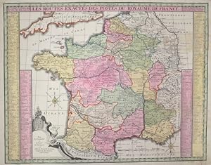
Les Routes exactes des Postes du Royaume de France.
Verlag: Artist: Seutter Matthias ( - 1757 ) Augsburg; issued in: Augsburg; ca: 1730, 1678
Anbieter: Antique Sommer& Sapunaru KG, München, Deutschland
Verkäuferbewertung 4 von 5 Sternen
Technic: Copper print, colorit: original colored, condition: Stain right corner, size (in cm): 45,5 x 58,5 cm, Map shows the whole of France with a coat of arms cartouche and a city index.
-
Borussiae Regnum cum adjacentisbus Regionibus mappa Geographica.
Verlag: Artist: Seutter Matthias ( - 1757 ) Augsburg; issued in: Augsburg; ca: 1720, 1678
Anbieter: Antique Sommer& Sapunaru KG, München, Deutschland
Verkäuferbewertung 4 von 5 Sternen
Technic: Copper print, colorit: original colored, condition: Very good, size (in cm): 19 x 25,5 cm, Map shows the whole of Prussia, two partial maps of Neufchate and Silesia. Furthermore, a title and a mileage indicator cartouche in black and white. Engraved by Andr. Silbereisen, edited by Matthias Seutter. From the pocket atlas.
-
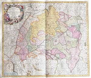
Circulus Suevicus in quo ducatus Wirtenbergensis
Verlag: Artist: Seutter Matthias ( - 1757 ) Augsburg; issued in: Augsburg; ca: 1728, 1678
Anbieter: Antique Sommer& Sapunaru KG, München, Deutschland
Verkäuferbewertung 3 von 5 Sternen
Technic: Copper print, colorit: original colored, condition: Very good, size (in cm): 50 x 58 cm, Splendid map showing the whole of Swabia with the towns of Augsburg, Ulm, Memmingen, Kempten, Nördlingen, Lindau on Lake Constance, etc.; Baden-Württemberg with Constance, Tübingen, Stuttgart, Heidelberg, Pforzheim, Freiburg im Breisgau, etc. and two cartouches.
-
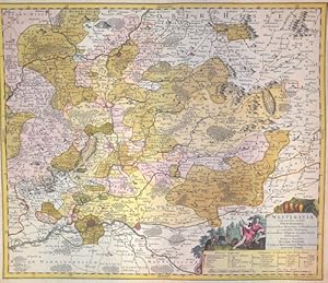
Wetteravia com omnibus inclusis Principatibus, Comitatibus, Dominiis et Praefecturis,
Verlag: Artist: Seutter Matthias ( - 1757 ) Augsburg; issued in: Augsburg; ca: 1730, 1678
Anbieter: Antique Sommer& Sapunaru KG, München, Deutschland
Verkäuferbewertung 3 von 5 Sternen
Technic: Copper print, colorit: original colored, condition: Perfect condition, size (in cm): 49 x 58, Map depicts Wetterai in Hassia with Frabkfurt, Friedberg and Gissen.
-
Nova Mappa Archiducatus Austriae Superioris
Verlag: Artist: Seutter Matthias ( - 1757 ) Augsburg; issued in: Augsburg; ca: 1728, 1678
Anbieter: Antique Sommer& Sapunaru KG, München, Deutschland
Verkäuferbewertung 4 von 5 Sternen
Technic: Copper print, colorit: original colored, condition: Lower left and right corner perfectly replaced, size (in cm): 48,5 x 57,5 cm, Map shows the whole of Upper Austria with magnificent title cartouche.
-
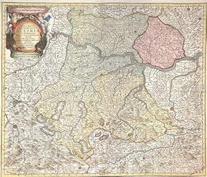
Archiducatus Austriae Inferioris
Verlag: Artist: Seutter Matthias ( - 1757 ) Augsburg; issued in: Augsburg; ca: 1730, 1678
Anbieter: Antique Sommer& Sapunaru KG, München, Deutschland
Verkäuferbewertung 4 von 5 Sternen
Technic: Copper print, colorit: original colored, condition: Perfect condition, size (in cm): 48,5 x 57,5 cm, Map shows the whole of Lower Austria with a magnificent cartouche and a coat of arms.
-
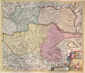
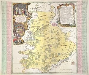
Synopsis Circuli Rhenani Inferioris Sive Electorum Rheni, exhibens Archi-Episcopatum Morguntinum Coloniensem, Trevirensem et Palatinatum Rheni .
Verlag: Artist: Seutter Matthias ( - 1757 ) Augsburg; issued in: Augsburg; ca: 1730, 1678
Anbieter: Antique Sommer& Sapunaru KG, München, Deutschland
Verkäuferbewertung 3 von 5 Sternen
Technic: Copper print, colorit: original colored, condition: Some folds perfectly set down,upper and lower margin replaced, size (in cm): 49 x 57 cm, Map shows the course of the Rhine from Düsseldorf via Cologne, Bonn, Koblenz, Mainz, Worms, Mannheim to Speyer. It also shows the Rhine-Lahn district with the towns of Nassau, Dietz, Limburg an der Lahn, Runkel, Villmar, Wetzlar, Gießen, Marburg etc. The Main with Rüsselsheim, Frankfurt, Hanau, Wertheim and the Moselle from Koblenz to Trier. A mileage scale at the top right and a magnificent title cartouche with a water god, putti and four coats of arms of Trier, Mainz, Cologne and the Palatinate at the bottom left.
-
Ad Ducat. Wurtenbergicum ad Terr. Ulm
Verlag: Artist: Seutter Matthias ( - 1757 ) Augsburg; issued in: Augsburg; ca: 1730, 1678
Anbieter: Antique Sommer& Sapunaru KG, München, Deutschland
Verkäuferbewertung 4 von 5 Sternen
Technic: Copper print, colorit: original colored, condition: Upper and lower margin perfectly replaced, size (in cm): 54 x 54, Map depicts the southern part of baden Wurtemberg with Hohentwies, Ueberliongen and the north part of the Lac de Constanz. Also ist shows the city of tlingen, Biberach, etc. and Ulm.
-
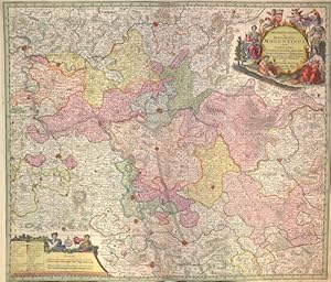
Archiepiscopatus et Electoratus Moguntinus
Verlag: Artist: Seutter Matthias ( - 1757 ) Augsburg; issued in: Augsburg; ca: 1730, 1678
Anbieter: Antique Sommer& Sapunaru KG, München, Deutschland
Verkäuferbewertung 4 von 5 Sternen
Technic: Copper print, colorit: original colored, condition: Right and left margin perfectly replaced, centerfold on lower part restored, size (in cm): 49 x 57cm, Map shows Hesse and its surrounding states with a splendid title cartouche and a mileage indicator cartouche.
-

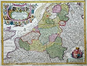
Belgium Foederatum auctius et emendatius edit Cura et studio
Verlag: Artist: Seutter Matthias ( - 1757 ) Augsburg; issued in: Augsburg; ca: 1728, 1678
Anbieter: Antique Sommer& Sapunaru KG, München, Deutschland
Verkäuferbewertung 4 von 5 Sternen
Technic: Wood engraving, colorit: original colored, condition: Bottom corners, outside expertly replaced, size (in cm): 50 x 57 cm, Map shows the entire Netherlands with a magnificent cartouche in black and white. Furthermore, two partial maps with South-East Asia and ?Limburgum Batavum? with the cities of Valkenburg and Maastrich.
-

Archiepiscopatus et Electoratus Moguntinus ut et Comitatus Uterq. Catimelibocens. Wertheimensis Erpacens
Verlag: Artist: Seutter Matthias ( - 1757 ) Augsburg; issued in: Augsburg; ca: 1740, 1678
Anbieter: Antique Sommer& Sapunaru KG, München, Deutschland
Verkäuferbewertung 4 von 5 Sternen
Technic: Copper print, colorit: original colored, condition: Upper and lower margin replaced and assembled, size (in cm): 49 x 57 cm, Map shows the course of the Rhine from Koblenz via Mainz to Speyer and the course of the Main with Frankfurt am Main, Hanau Wertheim to Gemünden am Main. Furthermore, a title cartouche with the coat of arms of the Mainz diocese, the god of wine (Bacchus), the goddess of the hunt (Diana), Hermes, Ares and a mileage indicator cartouche with index.
-
Praefecturae Leucopetranae.
Verlag: Artist: Seutter Matthias ( - 1757 ) Augsburg; issued in: Augsburg; ca: 17828, 1678
Anbieter: Antique Sommer& Sapunaru KG, München, Deutschland
Verkäuferbewertung 3 von 5 Sternen
Technic: Copper print, colorit: original colored, condition: Perfect condition, size (in cm): 48,5 x 58,5, Map depicts the Burgenland area in Sachsen Anhalt with the city of Weissenfels, Teuchern, Zeitz, elsdorf, Schkölen (Saale-Holzlandkreis, Thüringen)? two decorative carouches with coat of arms on the right and left side.
-

Atlas Novus sive Tabulae Geographica.
Verlag: Artist: Seutter Matthias ( - 1757 ) Augsburg; issued in: Augsburg; ca: 1730, 1678
Anbieter: Antique Sommer& Sapunaru KG, München, Deutschland
Verkäuferbewertung 4 von 5 Sternen
Kunst / Grafik / Poster
Technic: Copper print, colorit: original colored, condition: Very good, size (in cm): 50 x 28, Titlepage from the Atlas Novus sive Tabulae Geographica, from M. Seutter.