
Gesamtpreis (1 Artikel Artikel):
Versandziel:

seutter c (10 Ergebnisse)
Direkt zu den wichtigsten Suchergebnissen
Suchfilter
Produktart
- Alle Product Types
- Bücher (4)
- Magazine & Zeitschriften (Keine weiteren Ergebnisse entsprechen dieser Verfeinerung)
- Comics (Keine weiteren Ergebnisse entsprechen dieser Verfeinerung)
- Noten (Keine weiteren Ergebnisse entsprechen dieser Verfeinerung)
- Kunst, Grafik & Poster (3)
- Fotografien (Keine weiteren Ergebnisse entsprechen dieser Verfeinerung)
- Karten (3)
- Manuskripte & Papierantiquitäten (Keine weiteren Ergebnisse entsprechen dieser Verfeinerung)
Zustand Mehr dazu
- Neu (Keine weiteren Ergebnisse entsprechen dieser Verfeinerung)
- Wie Neu, Sehr Gut oder Gut Bis Sehr Gut (2)
- Gut oder Befriedigend (1)
- Ausreichend oder Schlecht (Keine weiteren Ergebnisse entsprechen dieser Verfeinerung)
- Wie beschrieben (7)
Einband
- alle Einbände
- Hardcover (Keine weiteren Ergebnisse entsprechen dieser Verfeinerung)
- Softcover (Keine weiteren Ergebnisse entsprechen dieser Verfeinerung)
Weitere Eigenschaften
- Erstausgabe (2)
- Signiert (Keine weiteren Ergebnisse entsprechen dieser Verfeinerung)
- Schutzumschlag (Keine weiteren Ergebnisse entsprechen dieser Verfeinerung)
- Angebotsfoto (7)
Sprache (3)
Preis
- Beliebiger Preis
- Weniger als EUR 20 (Keine weiteren Ergebnisse entsprechen dieser Verfeinerung)
- EUR 20 bis EUR 45 (Keine weiteren Ergebnisse entsprechen dieser Verfeinerung)
- Mehr als EUR 45
Gratisversand
- Kostenloser Versand nach USA (Keine weiteren Ergebnisse entsprechen dieser Verfeinerung)
Land des Verkäufers
Verkäuferbewertung
-
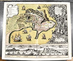
Plan tres exact et vue de la ville, baye, et des nouvelles fortifications de Gibraltar, situče au detroi de ce nom, tirč de l'original de M. Harcourt par Albert Charl Seutter.
Sprache: Französisch
Verlag: Augsbourg, 1740
Anbieter: BALAGUÉ LLIBRERIA ANTIQUARIA, Santa Coloma de Farners, GI, Spanien
Verkäuferbewertung 5 von 5 Sternen

Karte Erstausgabe
Sin Encuadernar. Zustand: Muy bien. 1Ş Edición. 63 x 53 cm. Iluminado a mano de época.
-

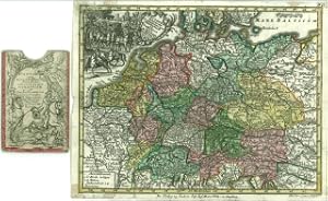
Ansbach. Marchionatus Onoldini Comitatus Oettingensis Praepositurae Elevacensis et Pappenheimensis.
Verlag: Augsburg, M. Seutter. (Ca. 1740)., 1740
Anbieter: Daniel Thierstein, Bern, Schweiz
Verbandsmitglied: GIAQ ILAB VEBUKU
Verkäuferbewertung 4 von 5 Sternen

63x58 cm. Grenz- und flächenkolorierte Kupferstichkarte mit Kartusche. Mittelfalz. Sammlung Ryhiner 9654. - Originalausgabe. - Die Karte zeigt die Markgrafschaft Ansbach. Gebiet: Erlangen, Ingolstadt, Augsburg, Schwäbisch Hall. - Ränder etwas angestaubt und lädiert. Sprache: n.
-

Plan trčs exact et vüe de la ville, baye et des nouvelles fortifications de Gibraltar.
Verlag: Augsburgo, c.1730, 1730
Anbieter: Librería Antonio Castro, SEVILLA, SE, Spanien
Verbandsmitglied: AILA ILAB SEVILLA
Verkäuferbewertung 5 von 5 Sternen
Imagen: 49,5x57,4. Papel: 52x61,5. Impresionante mapa grabado al cobre con color a mano de época. Plano de Gibraltar basado en Harcourt, con gran cartela y leyenda en parte superior izquierda. Abajo, dos vistas del Estrecho, una desde el Mediterráneo y otra desde el Atlántico, con leyendas. Buen estado. Ejemplar que destaca por su atractivo color. Raro. Albert Seutter, hijo de Georg Matthaeus Seutter produjo relativamente pocos mapas y ningún atlas.
-

Spatiosissimum Russiae Magnae juxta recentissimas Observationes Mappa Geographica accuratissime delineatum opera et sumtibus Tobiae Conradi Lotteri, Geogr. et Chalcogr. Augustae Vindel.
Verlag: Tobias Conrad Lotter c. 1757, Augsburg, 1757
Anbieter: Alexandre Antique Prints, Maps & Books, Toronto, ON, Kanada
Verkäuferbewertung 5 von 5 Sternen
Karte
Title cartouche in lower left depicts the shield of Russia, an Imperial solider, and two travelers. The lower right features a small legend., Size : 510x590 (mm), 20.08x23.23 (Inches), Hand Colored in Outline Minor browning along central fold, otherwise Very Good; laid down on acid-free tissue paper for long-term preservation.
-
Praefecturae Saxonicae Wurcensis, Eilenburgensis, Dubensis, Geographica accuratione, secundum oppida, vicos, pagos, vinias descriptae, a Matthaeo Seuttero, S.C. M. Geogr. Aug. Vindel.
Verlag: Tobias Conrad Lotter c. 1750, Augsburg, 1750
Anbieter: Alexandre Antique Prints, Maps & Books, Toronto, ON, Kanada
Verkäuferbewertung 5 von 5 Sternen
Zustand: Very Good; This is a map of the wine region in Saxony, Germany., Size : 500x580 (mm), 19.69x22.83 (Inches), Original Hand Coloring.
-
Pagi Basileensis, qui pars esr republicae Helvetiorum cum adjacentibus terrarum tractibus nova eaque accurata mappa geographica concinnata opera et studio Matthaei Seutteri Georgraphi Caesarei Aug. Vindel.
Sprache: Latein
Verlag: Seutter, Matthäus, Augsburg, 1750, 1750
Anbieter: Antiquariat Carl Wegner, Berlin, B, Deutschland
Verbandsmitglied: GIAQ
Verkäuferbewertung 5 von 5 Sternen
Erstausgabe
Nicht gebunden. 57,5 : 49,5 cm Stichgröße / 60,0 : 53,5 Blattgröße. Altkolorierter Kupferstich von Tobias Conrad Lotter. Unten links im barocken Figuren-Schmuckemblem betitelt, unten rechts eine weitere figürliche Kartusche mit Ansicht der Stadt Basel, darunter mit dem Vermerk: Tob. Conr. Lotter sculps. Auf der Karte verteilt sieben kleine Wappen. Detaillierte Karte mit alter Grenzkolorierung. Das Blatt im oberen Rand mit bis zu 8 cm reinreichendem alten Feuchtrand. Auch sonst etwas gebräunt. Insgesamt durchaus gut erhalten. -- 57.5 : 49.5 cm engraving size / 60.0 : 53.5 sheet size. Old colored copperplate engraving by Tobias Conrad Lotter. Titled lower left within a baroque figural ornamental emblem, lower right another figural cartouche with a view of the city of Basel, below with the note: Tob. Conr. Lotter sculps. Seven small coats of arms are distributed across the map. Detailed map with old border coloring. The upper margin of the sheet has an old wet margin extending up to 8 cm. Also slightly browned elsewhere. Overall, in very good condition. -- Gravure (57,5 x 49,5 cm) / feuille (60 x 53,5 cm). Ancienne gravure sur cuivre coloriée de Tobias Conrad Lotter. Titrée en bas ŕ gauche dans un emblčme ornemental figuratif baroque, en bas ŕ droite dans un autre cartouche figuratif avec une vue de la ville de Bâle, avec la mention en dessous : Tobias Conrad Lotter sculpte. Sept petites armoiries sont réparties sur la carte. Carte détaillée avec ancienne coloration des bordures. La marge supérieure de la feuille présente une ancienne marge humide s'étendant jusqu'ŕ 8 cm. Légčrement brunie ailleurs. En trčs bon état général. -- Bitte Portokosten außerhalb EU erfragen! / Please ask for postage costs outside EU! / S ' il vous plait demander des frais de port en dehors de l ' UE! // Bitte beachten Sie auch unsere Fotos! / Please also note our photos! / Veuillez noter nos photos -- Lesen Sie etwas Schönes auf einer Bank in der Frühlingssonne! Wir haben die passende Lektüre. -- Wir kaufen Ihre werthaltigen Bücher! FL0799-319577.
-

S.R.I. Principat. et Archiepiscopatus Salisburgensis. Mappa geographica delineatus in qua Subjecta appertinent. finitima Regiones et Ditiones accuratiss. ob oculos ponuntur cura et studio Tob: Conrad Lotter, Geogr. Aug. Vind.
Sprache: Latein
Verlag: Augsburg, Lotter [zwischen 1760/1780], 1780
Anbieter: Antiquariat Weinek, Salzburg, Österreich
Verkäuferbewertung 4 von 5 Sternen
Kunst / Grafik / Poster
Altkolorierter Kupferstich. ca. 50 x 59 cm. Vgl. Schaup, S. 115: 3.4.1. - Randläsuren, mit hds. Nr. in linken oberen Ecke, mittig angeklebter Falz a. Rückseite, Gbrsp.
-
Circulus Austria accuratissime defignatus opera et impenfis Matth. Seutteri S. C. M. Geogr. Aug. Vind.
Sprache: Latein
Verlag: Augsburg, Ioh. Mart. Will [nach ], 1762
Anbieter: Antiquariat Weinek, Salzburg, Österreich
Verkäuferbewertung 4 von 5 Sternen
Kunst / Grafik / Poster
Altkolorierter Kupferstich. ca. 18,7 x 24,5 cm. In illustriertem Orig.-Etui. - Etui rückw. m. hds. Titelei, Gbrsp., Karte etw. fleckig, gefaltet. - Vgl. Schaup 114ff. Aus dem "Atlas Minor." des M. Seutter, die Reisekarten-Ausgabe.
-
Postarum diverticula et mansiones per Germaniam et Confin. Prov. opera M. Seutteri S. C. M. G. Aug. V. 30
Sprache: Latein
Verlag: Augsburg, Ioh. Mart. Will [nach ], 1762
Anbieter: Antiquariat Weinek, Salzburg, Österreich
Verkäuferbewertung 4 von 5 Sternen
Kunst / Grafik / Poster
Altkolorierter Kupferstich. ca. 18,7 x 24,5 cm. In illustriertem Orig.-Etui. - Etui rückw. m. hds. Titelei, Gbrsp., Karte etw. fleckig, ein ca. 4 cm Einriss entlang eines Buges, gefaltet. - Vgl. Schaup 114ff. Aus dem "Atlas Minor." des M. Seutter, die Reisekarten-Ausgabe.
-
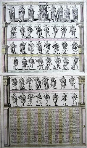
Ordines Sacri Romani Imp. ab Ottone III.
Erscheinungsdatum: 1720
Anbieter: Angelika C. J. Friebe Ltd. - MapWoman, Dorking, Vereinigtes Königreich
Verkäuferbewertung 4 von 5 Sternen
Karte
EUR 1.729,07
EUR 23,15 Versand
Versand von Vereinigtes Königreich nach USAAnzahl: 1 verfügbar
In den WarenkorbNo Binding. Zustand: Near Fine. Augsburg c1720 copper engraved prints with original wash colour. overall each 53 x 61 cm, plate 50,5 x 58,5 cm. folds as issued; some rust spots; both sheets: repair to c'folds; top right corners: hand written annotations; o/w exc. cond. This very decorative engraving is printed on two sheets and depicts the ranks of dignitaries of the Holy Roman Empire who were able to vote in the Imperial Diet. In the top rank, with the Emperor seated in the middle, are three ecclesiastical to the left and four lay dignitaries to the right. Below are four dukes and four marquesses; in the third and forth rank are four provincial dignitaries four military dignitaries each. The fifth and sixth rank are the burghers and freemen. Below is an explanatory text in Latin and German. This engraving was first published in 1593 in Gerard de Jode's atlas but later, the plates were purchased by Vrients and from 1603 onwards, it appeared in Ortelius' 'Theatrum' as well as in the 'Paragon', with the text box a lot smaller. [ref: 3041].

