Servoss r d (1 Ergebnisse)
Verlag: Harper & Brothers, New York, 1899
Anbieter: Argosy Book Store, ABAA, ILAB, New York, NY, USAArgosy Book Store, ABAA, ILAB
Verkäufer/-in kontaktierenVerkäufer/-in mit 5 SternenZustand: Gebraucht
EUR 270,78
EUR 5,26 VersandVersand innerhalb von USAAnzahl: 1 verfügbar
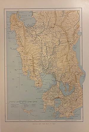
In den Warenkorbunbound. Woodcut. Image measures 13 1/2" x 9 1/2" Scarce wartime map of the Philippines issued after the Spanish-American War. Showing the central part of the island of Luzon around the city of Manila, this map depicts the region in great detail. Railroads, wagon roads, horse roads, and trails are shown. Cities, villages, and sm…all settlements are labeled. Topography is rendered by hachure. This map appeared in in "Harper's Pictorial History of the War with Spain", 1899.
