
Gesamtpreis (1 Artikel Artikel):
Versandziel:

senecal c o (10 Ergebnisse)
Direkt zu den wichtigsten Suchergebnissen
Suchfilter
Produktart
- Alle Product Types
- Bücher (3)
- Magazine & Zeitschriften (Keine weiteren Ergebnisse entsprechen dieser Verfeinerung)
- Comics (Keine weiteren Ergebnisse entsprechen dieser Verfeinerung)
- Noten (Keine weiteren Ergebnisse entsprechen dieser Verfeinerung)
- Kunst, Grafik & Poster (Keine weiteren Ergebnisse entsprechen dieser Verfeinerung)
- Fotografien (Keine weiteren Ergebnisse entsprechen dieser Verfeinerung)
- Karten (7)
- Manuskripte & Papierantiquitäten (Keine weiteren Ergebnisse entsprechen dieser Verfeinerung)
Zustand Mehr dazu
- Neu (Keine weiteren Ergebnisse entsprechen dieser Verfeinerung)
- Wie Neu, Sehr Gut oder Gut Bis Sehr Gut (Keine weiteren Ergebnisse entsprechen dieser Verfeinerung)
- Gut oder Befriedigend (4)
- Ausreichend oder Schlecht (Keine weiteren Ergebnisse entsprechen dieser Verfeinerung)
- Wie beschrieben (6)
Einband
- alle Einbände
- Hardcover (Keine weiteren Ergebnisse entsprechen dieser Verfeinerung)
- Softcover (1)
Weitere Eigenschaften
- Erstausgabe (2)
- Signiert (Keine weiteren Ergebnisse entsprechen dieser Verfeinerung)
- Schutzumschlag (Keine weiteren Ergebnisse entsprechen dieser Verfeinerung)
- Angebotsfoto (5)
Sprache (1)
Preis
- Beliebiger Preis
- Weniger als EUR 20 (Keine weiteren Ergebnisse entsprechen dieser Verfeinerung)
- EUR 20 bis EUR 45
- Mehr als EUR 45
Gratisversand
- Kostenloser Versand nach USA (Keine weiteren Ergebnisse entsprechen dieser Verfeinerung)
Land des Verkäufers
Verkäuferbewertung
-
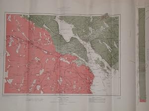
Province of Nova Scotia, Halifax County (City of Halifax Sheet, No. 68)
Verlag: Canada Department of Mines, Geological Survey Branch, Canada, 1908
Anbieter: RareNonFiction, IOBA, Ladysmith, BC, Kanada
Verbandsmitglied: IOBA
Verkäuferbewertung 5 von 5 Sternen

Karte Erstausgabe
Paperback. Zustand: Good. Senecal, C.O.; Yorston, R.B. Faribault, E.R. (illustrator). First Edition. Approx. 27" x 19". Library markings. Faint discolouration to upper right corner.
-

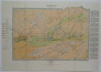
Hudson Bay and James Bay
Verlag: geological Survey of Canada c.1885, Ottawa, 1885
Anbieter: Alexandre Antique Prints, Maps & Books, Toronto, ON, Kanada
Verkäuferbewertung 5 von 5 Sternen
Karte
Zustand: Very Good. Size : 890x455 (mm), 35.04x17.91 (Inches), Printed in Color.
-
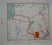
Geological Survey of Canada / Province of Ontario Thunder Bay and Rainy River Districts.
Verlag: Geological Survey of Canada, Ottawa, 1897
Anbieter: Alexandre Antique Prints, Maps & Books, Toronto, ON, Kanada
Verkäuferbewertung 5 von 5 Sternen
Karte
Zustand: Very Good, originally folded. Size : 320x470 (mm), 12.625x18.5 (Inches), Printed in Color.
-
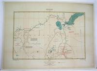
Map of Labrador Peninsula
Verlag: Geological Survey of Canada, Ottawa, 1896
Anbieter: Alexandre Antique Prints, Maps & Books, Toronto, ON, Kanada
Verkäuferbewertung 5 von 5 Sternen
Karte
Zustand: Excellent. Size : 490x560 (mm), 19.25x22 (Inches), Printed in Color.
-
Country Between Lower Portions of Peace and Athabaska Rivers
Verlag: Montreal, 1897
Anbieter: Alexandre Antique Prints, Maps & Books, Toronto, ON, Kanada
Verkäuferbewertung 5 von 5 Sternen
Karte
Size : 420x645 (mm), 16.5x25.375 (Inches), Printed in Color Excellent, laid on acid free canvas for long term preservation.
-
Nipissing District Ont., and Pontiac county Que.
Verlag: Geological Survey of Canada, Canada, 1897
Anbieter: Alexandre Antique Prints, Maps & Books, Toronto, ON, Kanada
Verkäuferbewertung 5 von 5 Sternen
Karte
Zustand: Very Good. Nipissing District Ontario, and Pontiac county Quebec. (Lake Temiscaming Sheet), Size : 320x470 (mm), 12.625x18.5 (Inches), Printed in Color.
-
Map of Part of Northwestern Ontario North of Lake Superior to illustrate summary report by W.J. Wilson
Verlag: Geological Survey of Canada, Canada, 1904
Anbieter: Alexandre Antique Prints, Maps & Books, Toronto, ON, Kanada
Verkäuferbewertung 5 von 5 Sternen
Karte
Zustand: Very Good. Thunder Bay, Size : 360x350 (mm), 14.125x13.75 (Inches), Hand Colored.
-
Index Map Shewing the Route followed by the Members of the Yukon Expedition
Verlag: Canada, , c.1891., 1891
Anbieter: Alexandre Antique Prints, Maps & Books, Toronto, ON, Kanada
Verkäuferbewertung 5 von 5 Sternen
Size: 405 x 625, 15 7/8" x 24 5/8". Printed in Color, Minor restoration to the central fold, laid on acid free paper for long term preservation, otherwise in very good condition.
-

Colour Printing of Geological Maps.
Erscheinungsdatum: 1925
Anbieter: Henry Sotheran Ltd, London, Vereinigtes Königreich
Verbandsmitglied: ABA ILAB PBFA
Verkäuferbewertung 5 von 5 Sternen
Erstausgabe
EUR 59,47
EUR 46,19 Versand
Versand von Vereinigtes Königreich nach USAAnzahl: 1 verfügbar
In den WarenkorbOttawa: F.A. Acland. 1925. 8vo. Recent black paper wrapper, paper label to front; pp. 4, 4 colour plates, text diagrams; fine.First edition. Canada Department of Mines Geological Survey Bulletin No. 39, Geological Series, No. 44. A fascinating pamphlet on the correct desgn and colouring of geological maps.
-
Geological Map of Alberta, Saskatchewan and Manitoba. Scale 1: 217 600.
Anbieter: Antiquariat Bernard Richter, Baden-Baden, Deutschland
Verkäuferbewertung 2 von 5 Sternen

(Map 55 A). Folded map in color ( 62X88 cm). [Ottawa?], Canada, Dept. of Mines, Geological Survey 1913. - - "Prepared to accompany: "Oil and gas prospects of the northwest provinces of Canada". Memoir (Geological Survey of Canada) ; 29-E.".
