
Gesamtpreis (1 Artikel Artikel):
Versandziel:

saxton william (55 Ergebnisse)
Direkt zu den wichtigsten Suchergebnissen
Suchfilter
Produktart
- Alle Product Types
- Bücher (28)
- Magazine & Zeitschriften (Keine weiteren Ergebnisse entsprechen dieser Verfeinerung)
- Comics (Keine weiteren Ergebnisse entsprechen dieser Verfeinerung)
- Noten (Keine weiteren Ergebnisse entsprechen dieser Verfeinerung)
- Kunst, Grafik & Poster (Keine weiteren Ergebnisse entsprechen dieser Verfeinerung)
- Fotografien (Keine weiteren Ergebnisse entsprechen dieser Verfeinerung)
- Karten (27)
- Manuskripte & Papierantiquitäten (Keine weiteren Ergebnisse entsprechen dieser Verfeinerung)
Zustand Mehr dazu
- Neu (14)
- Wie Neu, Sehr Gut oder Gut Bis Sehr Gut (4)
- Gut oder Befriedigend (14)
- Ausreichend oder Schlecht (Keine weiteren Ergebnisse entsprechen dieser Verfeinerung)
- Wie beschrieben (23)
Einband
Weitere Eigenschaften
- Erstausgabe (15)
- Signiert (Keine weiteren Ergebnisse entsprechen dieser Verfeinerung)
- Schutzumschlag (Keine weiteren Ergebnisse entsprechen dieser Verfeinerung)
- Angebotsfoto (29)
Sprache (2)
Gratisversand
Land des Verkäufers
Verkäuferbewertung
-
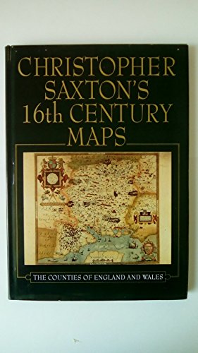
Christopher Saxton's 16th Century Maps
Sprache: Englisch
Verlag: Chatsworth Library 31/10/1992, 1992
ISBN 10: 1853103543 ISBN 13: 9781853103544
Anbieter: AwesomeBooks, Wallingford, Vereinigtes Königreich
Verkäuferbewertung 5 von 5 Sternen

EUR 12,03
EUR 5,84 Versand
Versand von Vereinigtes Königreich nach USAAnzahl: 2 verfügbar
In den WarenkorbZustand: Very Good. This book is in very good condition and will be shipped within 24 hours of ordering. The cover may have some limited signs of wear but the pages are clean, intact and the spine remains undamaged. This book has clearly been well maintained and looked after thus far. Money back guarantee if you are not satisfied. See all our books here, order more than 1 book and get discounted shipping. .
-
Christopher Saxton's 16th Century Maps
Sprache: Englisch
Verlag: Chatsworth Library 31/10/1992, 1992
ISBN 10: 1853103543 ISBN 13: 9781853103544
Anbieter: Bahamut Media, Reading, Vereinigtes Königreich
Verkäuferbewertung 5 von 5 Sternen
EUR 12,03
EUR 8,17 Versand
Versand von Vereinigtes Königreich nach USAAnzahl: 2 verfügbar
In den WarenkorbZustand: Very Good. Shipped within 24 hours from our UK warehouse. Clean, undamaged book with no damage to pages and minimal wear to the cover. Spine still tight, in very good condition. Remember if you are not happy, you are covered by our 100% money back guarantee.
-

Supplement to Saxton's Tax and Assessment Laws of the State of New York Containing All the General Tax and Assessment Laws of the State Passed by the Legislature of 1881 Classic Reprint
Anbieter: PBShop.store US, Wood Dale, IL, USA
Verkäuferbewertung 5 von 5 Sternen
PAP. Zustand: New. New Book. Shipped from UK. Established seller since 2000.
-

Excise Law of the State of New York With Civil Damage Act, and All Statutes, Including 1880 With Notes of Decisions of the Courts and Forms Classic Reprint
Anbieter: PBShop.store US, Wood Dale, IL, USA
Verkäuferbewertung 5 von 5 Sternen
PAP. Zustand: New. New Book. Shipped from UK. Established seller since 2000.
-
Supplement to Saxton's Tax and Assessment Laws of the State of New York Containing All the General Tax and Assessment Laws of the State Passed by the Legislature of 1881 Classic Reprint
Anbieter: PBShop.store UK, Fairford, GLOS, Vereinigtes Königreich
Verkäuferbewertung 5 von 5 Sternen
EUR 24,66
EUR 3,85 Versand
Versand von Vereinigtes Königreich nach USAAnzahl: 15 verfügbar
In den WarenkorbPAP. Zustand: New. New Book. Shipped from UK. Established seller since 2000.
-
Excise Law of the State of New York With Civil Damage Act, and All Statutes, Including 1880 With Notes of Decisions of the Courts and Forms Classic Reprint
Anbieter: PBShop.store UK, Fairford, GLOS, Vereinigtes Königreich
Verkäuferbewertung 5 von 5 Sternen
EUR 25,32
EUR 3,85 Versand
Versand von Vereinigtes Königreich nach USAAnzahl: 15 verfügbar
In den WarenkorbPAP. Zustand: New. New Book. Shipped from UK. Established seller since 2000.
-

Laws of the State of New York
Anbieter: PBShop.store US, Wood Dale, IL, USA
Verkäuferbewertung 5 von 5 Sternen
PAP. Zustand: New. New Book. Shipped from UK. Established seller since 2000.
-
Laws of the State of New York
Anbieter: PBShop.store UK, Fairford, GLOS, Vereinigtes Königreich
Verkäuferbewertung 5 von 5 Sternen
EUR 27,94
EUR 4,87 Versand
Versand von Vereinigtes Königreich nach USAAnzahl: 15 verfügbar
In den WarenkorbPAP. Zustand: New. New Book. Shipped from UK. Established seller since 2000.
-

Supplement to Saxton's Tax and Assessment Laws of the State of New York
Anbieter: PBShop.store US, Wood Dale, IL, USA
Verkäuferbewertung 5 von 5 Sternen
HRD. Zustand: New. New Book. Shipped from UK. Established seller since 2000.
-
Works in Progress
Verlag: Doubleday & Company, Inc., 1970
Anbieter: Southampton Books, Sag Harbor, NY, USA
Verkäuferbewertung 5 von 5 Sternen
Erstausgabe
Paperback. Zustand: Very Good. First Edition. First Edition, First Printing. Published by Doubleday & Company, Inc., 1970. Octavo. Paperback. Book is very good with shelf/edgewear. 100% positive feedback. 30 day money back guarantee. NEXT DAY SHIPPING! Excellent customer service. Please email with any questions. All books packed carefully and ship with free delivery confirmation/tracking. All books come with free bookmarks. Ships from Sag Harbor, New York.
-

Excise Law of the State of New York With Civil Damage Act, and All Statutes, Including 1880 With Notes of Decisions of the Courts and Forms Classic Reprint
Anbieter: PBShop.store US, Wood Dale, IL, USA
Verkäuferbewertung 5 von 5 Sternen
HRD. Zustand: New. New Book. Shipped from UK. Established seller since 2000.
-
Supplement to Saxton's Tax and Assessment Laws of the State of New York
Anbieter: PBShop.store UK, Fairford, GLOS, Vereinigtes Königreich
Verkäuferbewertung 5 von 5 Sternen
EUR 33,12
EUR 4,87 Versand
Versand von Vereinigtes Königreich nach USAAnzahl: 15 verfügbar
In den WarenkorbHRD. Zustand: New. New Book. Shipped from UK. Established seller since 2000.
-
Excise Law of the State of New York With Civil Damage Act, and All Statutes, Including 1880 With Notes of Decisions of the Courts and Forms Classic Reprint
Anbieter: PBShop.store UK, Fairford, GLOS, Vereinigtes Königreich
Verkäuferbewertung 5 von 5 Sternen
EUR 33,77
EUR 4,87 Versand
Versand von Vereinigtes Königreich nach USAAnzahl: 15 verfügbar
In den WarenkorbHRD. Zustand: New. New Book. Shipped from UK. Established seller since 2000.
-

Laws of the State of New York Relating to the Assessment and Collection of Taxes, Including the Statutes of 1880 Containing the Laws Relating to Under the General Tax Laws Notes of Judici
Anbieter: PBShop.store US, Wood Dale, IL, USA
Verkäuferbewertung 5 von 5 Sternen
HRD. Zustand: New. New Book. Shipped from UK. Established seller since 2000.
-
Laws of the State of New York Relating to the Assessment and Collection of Taxes, Including the Statutes of 1880 Containing the Laws Relating to Under the General Tax Laws Notes of Judici
Anbieter: PBShop.store UK, Fairford, GLOS, Vereinigtes Königreich
Verkäuferbewertung 5 von 5 Sternen
EUR 36,38
EUR 5,88 Versand
Versand von Vereinigtes Königreich nach USAAnzahl: 15 verfügbar
In den WarenkorbHRD. Zustand: New. New Book. Shipped from UK. Established seller since 2000.
-

EUR 35,95
EUR 48,99 Versand
Versand von Deutschland nach USAAnzahl: Mehr als 20 verfügbar
In den WarenkorbGebunden. Zustand: New.
-

Laws of the State of New York Relating to the Asssessment and Collection of Taxes : Including the Statutes of 1880; Containing the Laws Relating to Treasurers, Supervisors, Assessors, Collectors, and all Officers Under the General tax Laws; With Notes O
Sprache: Englisch
Verlag: Creative Media Partners, LLC Mai 2016, 2016
ISBN 10: 1355915635 ISBN 13: 9781355915638
Anbieter: AHA-BUCH GmbH, Einbeck, Deutschland
Verkäuferbewertung 5 von 5 Sternen
Buch. Zustand: Neu. Neuware - This work has been selected by scholars as being culturally important, and is part of the knowledge base of civilization as we know it. This work was reproduced from the original artifact, and remains as true to the original work as possible. Therefore, you will see the original copyright references, library stamps (as most of these works have been housed in our most important libraries around the world), and other notations in the work.This work is in the public domain in the United States of America, and possibly other nations. Within the United States, you may freely copy and distribute this work, as no entity (individual or corporate) has a copyright on the body of the work.As a reproduction of a historical artifact, this work may contain missing or blurred pages, poor pictures, errant marks, etc. Scholars believe, and we concur, that this work is important enough to be preserved, reproduced, and made generally available to the public. We appreciate your support of the preservation process, and thank you for being an important part of keeping this knowledge alive and relevant.
-
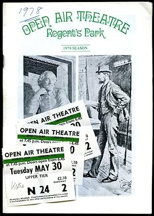
A Midsummer Night's Dream: Souvenir Theatre Programme Performed at Open Air Theatre, Regent's Park, London
Verlag: Performance Programme Dated Season. 1978., 1978
Anbieter: Little Stour Books PBFA Member, Canterbury, Vereinigtes Königreich
Verbandsmitglied: PBFA
Verkäuferbewertung 5 von 5 Sternen
EUR 9,65
EUR 35,12 Versand
Versand von Vereinigtes Königreich nach USAAnzahl: 1 verfügbar
In den WarenkorbZustand: Fine. Original stapled colour illustrated souvenir theatre programme 8˝'' x 6''. Contains 24 pages. In Fine condition. Member of the P.B.F.A. THEATRE PROGRAMMES.
-
Zustand: Sehr gut. Zustand: Sehr gut | Seiten: 272 | Sprache: Englisch | Produktart: Bücher | Keine Beschreibung verfügbar.
-
Selections from the Numismatist: United States coins
Verlag: Whitman Pub. Co., Racine, Wis., 1960, 1960
Anbieter: Joseph Valles - Books, Stockbridge, GA, USA
Verkäuferbewertung 5 von 5 Sternen
Hardcover. Zustand: Fine. No Jacket. 301 pages illustrations 24 cm OCLC 2578209 black cloth no dustjacket ; General contents: Introduction to coin collecting -- Collecting United States coins -- Background of American coinage -- Large and small cents -- Silver dollars -- Other regular issue copper and silver coins -- Gold coins --Commemoratives -- Mint engravers and dies -- Patterns ; FINE. Book.
-

Dunelmensis Episcopatus Qui Comitatus Est Palatinus Olim Pars Brigantum
Sprache: Englisch
Verlag: George Bishop & John Norton, London, UK, 1607
Anbieter: Hornseys, Ripon, Vereinigtes Königreich
Verbandsmitglied: PBFA
Verkäuferbewertung 5 von 5 Sternen
EUR 150,71
EUR 29,27 Versand
Versand von Vereinigtes Königreich nach USAAnzahl: 1 verfügbar
In den WarenkorbNo Binding. Zustand: Very Good Plus. 2nd Edition. Original copper-engraved map. Sheet size: 39.7cm x 32.4cm. Blank to the verso. Remnants of old tabs to the good, wide margins. Minor age toning and browning but in very good plus, bright, clean condition overall and a good, strong impression.
-
EBORACENSIS Comitatus Occidentalis vulgo WEST RIDING
Sprache: Englisch
Verlag: London
Anbieter: Hornseys, Ripon, Vereinigtes Königreich
Verbandsmitglied: PBFA
Verkäuferbewertung 5 von 5 Sternen
EUR 422,00
EUR 29,27 Versand
Versand von Vereinigtes Königreich nach USAAnzahl: 1 verfügbar
In den WarenkorbNo Binding. Zustand: Very Good. The earliest printed map dedicated solely to the West Riding. Early seventeenth century. Engraving with contemporary hand-colouring on laid paper. Sheet size: 34.5 cm x 28.4 cm. A finely engraved and highly decorative early map of the West Riding of Yorkshire derived from the groundbreaking county surveys of Christopher Saxton, widely regarded as the father of English cartography. The map was engraved by the Scottish engraver William Hole and forms part of the important early seventeenth-century tradition of reinterpreting Saxton's foundational surveys for a new generation of British atlases and geographical publications. Edition not evident. Blank verso. Impression shows signs of wear to the plate but does not have the added '48' plate number to the left hand corner. Date: c.1610-1637. A strong impression with contemporary or near-contemporary hand-colouring. Historic central fold as issued. General age toning, light surface wear, and minor handling marks consistent with age. The engraving remains sharp and well defined, with clear, legible place names and attractive colour. A well-preserved example of an important early Yorkshire county map.
-

Dunelmensis Episcopatus
Sprache: Englisch
Erscheinungsdatum: 1637
Anbieter: Hornseys, Ripon, Vereinigtes Königreich
Verbandsmitglied: PBFA
Verkäuferbewertung 5 von 5 Sternen
EUR 78,37
EUR 29,27 Versand
Versand von Vereinigtes Königreich nach USAAnzahl: 1 verfügbar
In den WarenkorbNo Binding. Zustand: Very Good. Original copper engraving. Date: 1637. Sheet size: 34.6cm x 30cm. Early hand-colouring. Close-cropped with very minor age-spotting. Central fold line. In very good, bright, clean condition.
-

Mongomery [Original Hand-Colored Engraved Map]:. Comitatus qui olim pars Ordouicum
Verlag: Camden?s Britannia, 1637
Anbieter: Lux Mentis, Booksellers, ABAA/ILAB, Portland, ME, USA
Verbandsmitglied: ABAA ILAB MABA MBS
Verkäuferbewertung 5 von 5 Sternen
Zustand: Near Fine. Hand coloured map of Montgomery County in Wales. This map was originally published in Camden's Britannia which was the first in which each county was printed on a separate sheet. The first issue of the series was in 1607 (with Latin text at verso) with two editions in 1610 and 1637. The later two had not text on the back and plate numbers may be found on the 1637 issue. Toning notwithstanding, a lovely example with wide margins remaining in an elegant black enamel and gilt frame. Light, even toning, else bright and clean. Hand coloured map. Approximately 15x13" overall, image is 10.5x12.5".
-
Lincolniae Comitatus ubi olim Insederunt Coritani [Map of Lincolnshire]
Verlag: [Published by George Bishop & John Norton] no date givenc1607-1620, [London], 1607
Anbieter: Keoghs Books, Skipton, Vereinigtes Königreich
Verbandsmitglied: PBFA
Verkäuferbewertung 5 von 5 Sternen
Karte Erstausgabe
EUR 361,72
EUR 32,78 Versand
Versand von Vereinigtes Königreich nach USAAnzahl: 1 verfügbar
In den Warenkorb, hand-coloured map of Lincolnshire with black titles, decorative title with scale of miles to upper right hand corner (Scala Miliarium Anglocorum to 10, Sculp), single border (including towns, rivers, forests, hills), watermark (grapes with coronet), imprint derived from atlas (from William Camden's Britannia with Latin text 'Lincolne-shire' with initial to left-hand side of reverse) First Edition , slight wear to edges with some tape, amateur repair with tape to reverse of upper left-hand corner, fold line, faint foxing, good condition , paper 32.5 x 39 cms Paperback ISBN:
-
![Bild des Verkäufers für [Befordshire]. Bedford Comitatus olim pars Cathifuclanorum. zum Verkauf von Robert Frew Ltd. ABA ILAB](https://pictures.abebooks.com/inventory/md/md30894927370.jpg)
[Befordshire]. Bedford Comitatus olim pars Cathifuclanorum.
Verlag: LondonImpensis Georgii Bishop & Ioannis Norton ., 1610
Anbieter: Robert Frew Ltd. ABA ILAB, London, Vereinigtes Königreich
Verbandsmitglied: ABA ILAB PBFA
Verkäuferbewertung 5 von 5 Sternen
Karte Erstausgabe
EUR 90,43
EUR 11,71 Versand
Versand von Vereinigtes Königreich nach USAAnzahl: 1 verfügbar
In den WarenkorbOriginal uncoloured engraved map of Bedfordshire trimmed to neatline and backed onto 18th century laid paper. Map dimensions 27.5 x 33 cm, overall backing-sheet size 32 x 40 cm. Rather soiled along right hand margin (mainly to backing-sheet), small tears to lower margin of backing sheet with old paper repair to verso, a bit unevenly toned, small losses to lower right corner. An early decorative map of Bedfordshire engraved by William Kip based on the earlier maps by Elizabethan cartographer Christopher Saxton first published in the 1607 edition of William Camden's Britannia.* This example is from the first English edition of Camden's Britannia published in 1610, without any text on the verso. Embellished with compass rose and decorative cartouche. *Britannia, first published in 1586, was one of the most popular and influential books of the period. The work of the Elizabethan antiquarian, William Camden (1551-1623), it was a detailed historical and topographical description of Great Britain. Its patriotic sentiments, in particular, both appealed to and generated the growing sense of nationalism that was coursing through late Tudor / early Stuart society. Between 1607 and 1637, county maps engraved by William Kip and William Hole, and based largely on Saxton's surveys, were added. (Skelton, 6).
-
![Bild des Verkäufers für [West Riding of Yorkshire]. Eboracensis Comitatus pars Septentrionalis Vulgo West Riding. zum Verkauf von Robert Frew Ltd. ABA ILAB](https://pictures.abebooks.com/inventory/md/md30894925645.jpg)
[West Riding of Yorkshire]. Eboracensis Comitatus pars Septentrionalis Vulgo West Riding.
Verlag: LondonImpensis Georgii Bishop & Ioannis Norton ., 1610
Anbieter: Robert Frew Ltd. ABA ILAB, London, Vereinigtes Königreich
Verbandsmitglied: ABA ILAB PBFA
Verkäuferbewertung 5 von 5 Sternen
Karte Erstausgabe
EUR 120,57
EUR 11,71 Versand
Versand von Vereinigtes Königreich nach USAAnzahl: 1 verfügbar
In den WarenkorbOriginal uncoloured engraved map of West Riding of Yorkshire trimmed to neatline and backed onto 18th century laid paper. Map dimensions 27 x 32 cm, overall backing-sheet size 32 x 40 cm. Faintly smudged and browned to large portion of map. An early decorative map of West Riding of Yorkshire engraved by William Hole based on the earlier maps by Elizabethan cartographer Christopher Saxton first published in the 1607 edition of William Camden's Britannia.* This example is from the first English edition of Camden's Britannia published in 1610, without any text on the verso. Embellished with compass rose, compass dividers, and decorative cartouche. *Britannia, first published in 1586, was one of the most popular and influential books of the period. The work of the Elizabethan antiquarian, William Camden (1551-1623), it was a detailed historical and topographical description of Great Britain. Its patriotic sentiments, in particular, both appealed to and generated the growing sense of nationalism that was coursing through late Tudor / early Stuart society. Between 1607 and 1637, county maps engraved by William Kip and William Hole, and based largely on Saxton's surveys, were added. (Skelton, 6).
-
![Bild des Verkäufers für [Monmouthshire]. Monumethensis comitatus, quem olim incoluerunt silures. zum Verkauf von Robert Frew Ltd. ABA ILAB](https://pictures.abebooks.com/inventory/md/md30894930062.jpg)
[Monmouthshire]. Monumethensis comitatus, quem olim incoluerunt silures.
Verlag: LondonImpensis Georgii Bishop & Ioannis Norton ., 1610
Anbieter: Robert Frew Ltd. ABA ILAB, London, Vereinigtes Königreich
Verbandsmitglied: ABA ILAB PBFA
Verkäuferbewertung 5 von 5 Sternen
Karte Erstausgabe
EUR 120,57
EUR 11,71 Versand
Versand von Vereinigtes Königreich nach USAAnzahl: 1 verfügbar
In den WarenkorbOriginal uncoloured engraved map of Monmouthshire trimmed to neatline and backed onto 18th century laid paper. Map dimensions 27.5 x 34 cm, overall backing-sheet size 32 x 40 cm. A bit toned mainly to bottom right corner, generally very good. An early decorative map of Monmouthshire engraved by William Hole based on the earlier maps by Elizabethan cartographer Christopher Saxton first published in the 1607 edition of William Camden's Britannia.* This example is from the first English edition of Camden's Britannia published in 1610, without any text on the verso. Embellished with royal coat of arms, compass dividers, compass rose, sea galleon, and decorative cartouche. *Britannia, first published in 1586, was one of the most popular and influential books of the period. The work of the Elizabethan antiquarian, William Camden (1551-1623), it was a detailed historical and topographical description of Great Britain. Its patriotic sentiments, in particular, both appealed to and generated the growing sense of nationalism that was coursing through late Tudor / early Stuart society. Between 1607 and 1637, county maps engraved by William Kip and William Hole, and based largely on Saxton's surveys, were added. (Skelton, 6).
-
![Bild des Verkäufers für [Staffordshire]. Staffordić Comitatvs pars olim cornauiorum. zum Verkauf von Robert Frew Ltd. ABA ILAB](https://pictures.abebooks.com/inventory/md/md30894927368.jpg)
[Staffordshire]. Staffordić Comitatvs pars olim cornauiorum.
Verlag: LondonImpensis Georgii Bishop & Ioannis Norton ., 1610
Anbieter: Robert Frew Ltd. ABA ILAB, London, Vereinigtes Königreich
Verbandsmitglied: ABA ILAB PBFA
Verkäuferbewertung 5 von 5 Sternen
Karte Erstausgabe
EUR 120,57
EUR 11,71 Versand
Versand von Vereinigtes Königreich nach USAAnzahl: 1 verfügbar
In den WarenkorbOriginal uncoloured engraved map of Staffordshire trimmed to neatline and backed onto 18th century laid paper. Map dimensions 27 x 37.5 cm, overall backing-sheet size 32 x 40 cm. Smudged overall and with a bit of browning. An early decorative map of Staffordshire engraved by William Kip based on the earlier maps by Elizabethan cartographer Christopher Saxton first published in the 1607 edition of William Camden's Britannia.* This example is from the first English edition of Camden's Britannia published in 1610, without any text on the verso. Embellished with decorative cartouche and compass dividers. *Britannia, first published in 1586, was one of the most popular and influential books of the period. The work of the Elizabethan antiquarian, William Camden (1551-1623), it was a detailed historical and topographical description of Great Britain. Its patriotic sentiments, in particular, both appealed to and generated the growing sense of nationalism that was coursing through late Tudor / early Stuart society. Between 1607 and 1637, county maps engraved by William Kip and William Hole, and based largely on Saxton's surveys, were added. (Skelton, 6).
-
![Bild des Verkäufers für [Denbighshire]. Denbigh Comitatus pas olim Ordovicvm. zum Verkauf von Robert Frew Ltd. ABA ILAB](https://pictures.abebooks.com/inventory/md/md30894927366.jpg)
[Denbighshire]. Denbigh Comitatus pas olim Ordovicvm.
Verlag: LondonImpensis Georgii Bishop & Ioannis Norton ., 1610
Anbieter: Robert Frew Ltd. ABA ILAB, London, Vereinigtes Königreich
Verbandsmitglied: ABA ILAB PBFA
Verkäuferbewertung 5 von 5 Sternen
Karte Erstausgabe
EUR 120,57
EUR 11,71 Versand
Versand von Vereinigtes Königreich nach USAAnzahl: 1 verfügbar
In den WarenkorbOriginal uncoloured engraved map of Denbighshire trimmed to neatline and backed onto 18th century laid paper. Map dimensions 27 x 32 cm, overall backing-sheet size 32 x 40 cm. 13 cm split down middle, minimal toning and spotting. An early decorative map of Denbighshire engraved by William Hole based on the earlier maps by Elizabethan cartographer Christopher Saxton first published in the 1607 edition of William Camden's Britannia.* This example is from the first English edition of Camden's Britannia published in 1610, without any text on the verso. *Britannia, first published in 1586, was one of the most popular and influential books of the period. The work of the Elizabethan antiquarian, William Camden (1551-1623), it was a detailed historical and topographical description of Great Britain. Its patriotic sentiments, in particular, both appealed to and generated the growing sense of nationalism that was coursing through late Tudor / early Stuart society. Between 1607 and 1637, county maps engraved by William Kip and William Hole, and based largely on Saxton's surveys, were added. (Skelton, 6).


