

Gesamtpreis (1 Artikel Artikel):
Versandziel:

samuel thornton (15 Ergebnisse)
Direkt zu den wichtigsten Suchergebnissen
Suchfilter
Produktart
- Alle Product Types
- Bücher (12)
- Magazine & Zeitschriften (Keine weiteren Ergebnisse entsprechen dieser Verfeinerung)
- Comics (Keine weiteren Ergebnisse entsprechen dieser Verfeinerung)
- Noten (Keine weiteren Ergebnisse entsprechen dieser Verfeinerung)
- Kunst, Grafik & Poster (Keine weiteren Ergebnisse entsprechen dieser Verfeinerung)
- Fotografien (Keine weiteren Ergebnisse entsprechen dieser Verfeinerung)
- Karten (3)
- Manuskripte & Papierantiquitäten (Keine weiteren Ergebnisse entsprechen dieser Verfeinerung)
Zustand Mehr dazu
- Neu (6)
- Wie Neu, Sehr Gut oder Gut Bis Sehr Gut (Keine weiteren Ergebnisse entsprechen dieser Verfeinerung)
- Gut oder Befriedigend (2)
- Ausreichend oder Schlecht (1)
- Wie beschrieben (6)
Einband
Weitere Eigenschaften
- Erstausgabe (Keine weiteren Ergebnisse entsprechen dieser Verfeinerung)
- Signiert (Keine weiteren Ergebnisse entsprechen dieser Verfeinerung)
- Schutzumschlag (Keine weiteren Ergebnisse entsprechen dieser Verfeinerung)
- Angebotsfoto (4)
Sprache (2)
Gratisversand
Land des Verkäufers
Verkäuferbewertung
-

Laban's Theory of Movement : A New Perspective
Anbieter: Better World Books, Mishawaka, IN, USA
Verkäuferbewertung 5 von 5 Sternen

Zustand: Good. [1st American ed.]. Pages intact with minimal writing/highlighting. The binding may be loose and creased. Dust jackets/supplements are not included. Stock photo provided. Product includes identifying sticker. Better World Books: Buy Books. Do Good.
-

North American Health Care Policy in the 1990's
Anbieter: Anybook.com, Lincoln, Vereinigtes Königreich
Verkäuferbewertung 5 von 5 Sternen
EUR 12,96
EUR 15,69 Versand
Versand von Vereinigtes Königreich nach USAAnzahl: 1 verfügbar
In den WarenkorbZustand: Poor. This is an ex-library book and may have the usual library/used-book markings inside.This book has hardback covers. Book contains pen & pencil markings In poor condition, suitable as a reading copy. Please note the Image in this listing is a stock photo and may not match the covers of the actual item,650grams, ISBN:9780471940036.
-

Law of the North
Anbieter: Ria Christie Collections, Uxbridge, Vereinigtes Königreich
Verkäuferbewertung 5 von 5 Sternen
EUR 17,69
EUR 13,82 Versand
Versand von Vereinigtes Königreich nach USAAnzahl: Mehr als 20 verfügbar
In den WarenkorbZustand: New. In.
-

The Model Farms and Their Methods: Giving the Experiences of Over One Hundred Successful Farmers in the Various Branches of Husbandry in Different Portions of the Country; Stock Raising; Fruit Growing; Dairying; Tile Drainage; Cost and Profits of Mixed Hu
Anbieter: PBShop.store US, Wood Dale, IL, USA
Verkäuferbewertung 5 von 5 Sternen
PAP. Zustand: New. New Book. Shipped from UK. Established seller since 2000.
-
The Model Farms and Their Methods: Giving the Experiences of Over One Hundred Successful Farmers in the Various Branches of Husbandry in Different Portions of the Country; Stock Raising; Fruit Growing; Dairying; Tile Drainage; Cost and Profits of Mixed Hu
Anbieter: PBShop.store UK, Fairford, GLOS, Vereinigtes Königreich
Verkäuferbewertung 4 von 5 Sternen

EUR 33,13
EUR 7,80 Versand
Versand von Vereinigtes Königreich nach USAAnzahl: 15 verfügbar
In den WarenkorbPAP. Zustand: New. New Book. Shipped from UK. Established seller since 2000.
-

Law of the North
Anbieter: Ria Christie Collections, Uxbridge, Vereinigtes Königreich
Verkäuferbewertung 5 von 5 Sternen
EUR 31,14
EUR 13,82 Versand
Versand von Vereinigtes Königreich nach USAAnzahl: Mehr als 20 verfügbar
In den WarenkorbZustand: New. In.
-

The Model Farms and Their Methods: Giving the Experiences of Over One Hundred Successful Farmers in the Various Branches of Husbandry in Different Portions of the Country; Stock Raising; Fruit Growing; Dairying; Tile Drainage; Cost and Profits of Mixed Hu
Anbieter: PBShop.store US, Wood Dale, IL, USA
Verkäuferbewertung 5 von 5 Sternen
HRD. Zustand: New. New Book. Shipped from UK. Established seller since 2000.
-
The Model Farms and Their Methods: Giving the Experiences of Over One Hundred Successful Farmers in the Various Branches of Husbandry in Different Portions of the Country; Stock Raising; Fruit Growing; Dairying; Tile Drainage; Cost and Profits of Mixed Hu
Anbieter: PBShop.store UK, Fairford, GLOS, Vereinigtes Königreich
Verkäuferbewertung 4 von 5 Sternen
EUR 38,98
EUR 8,80 Versand
Versand von Vereinigtes Königreich nach USAAnzahl: 15 verfügbar
In den WarenkorbHRD. Zustand: New. New Book. Shipped from UK. Established seller since 2000.
-

Collapsible Soils in Louisiana.
Verlag: Baton Rouge:, 1972
Anbieter: Zubal-Books, Since 1961, Cleveland, OH, USA
Verkäuferbewertung 5 von 5 Sternen
Zustand: Very Good. *Price HAS BEEN REDUCED by 10% until Monday, June 1 (SALE item)* quarto, 131 pp., illustrated, issued as Louisiana State University, Division of Engineering Research, Bulletin 111; very good in original paper wrappers with cloth tape spine. - If you are reading this, this item is actually (physically) in our stock and ready for shipment once ordered. We are not bookjackers. Buyer is responsible for any additional duties, taxes, or fees required by recipient's country.
-
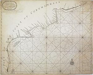
A New Chart of Part of the Coast of Coremandell from Armegon to Bimlepatam
Verlag: London
Anbieter: Argosy Book Store, ABAA, ILAB, New York, NY, USA
Verkäuferbewertung 5 von 5 Sternen
unbound. Map. Uncolored engraving. Image measures 17" x 21". Sheet measures 17 7/16" x 21 5/8". Beautiful early sea chart of the Coromandel coast in southeast India covering the state of Andhra Pradesh from Bheemunipatnam (Bimlepatnam) near Visakhapatnam to Armegon dating to circa 1711. Includes soundings in fathoms, coastal features, rhumb lines, villages and geographical features. Towns and forests rendered in profile. Originally published in John Thornton's (1641-1708) "English Pilot the Third Book, describing the Sea Coasts.in Oriental Navigation" in 1703. The "English Pilot" was the first English Atlas to chart American waters and was published in many editions from 1671 to 1803. Samuel Thornton (d. 1715) took over his father's business in 1707, and reissued many of his works including this map. Overall wear and scattered toning, narrow margins. Stain in lower left and near centerfold. Overall a lovely example.
-
![Bild des Verkäufers für A New Mapp Of the Island of Bombay and Sallset [and] an untitled manuscript chart of the Arabian Peninsula, Gujarat, and the Malabar coast of India. zum Verkauf von Daniel Crouch Rare Books Ltd](https://pictures.abebooks.com/inventory/md/md32116922760.jpg)
A New Mapp Of the Island of Bombay and Sallset [and] an untitled manuscript chart of the Arabian Peninsula, Gujarat, and the Malabar coast of India.
Verlag: London, Hydrographer to ye Hono.ble East- India-Company; at ye Signe of ye Plat in ye Minories,
Anbieter: Daniel Crouch Rare Books Ltd, London, Vereinigtes Königreich
Verbandsmitglied: ABA ILAB PBFA
Verkäuferbewertung 4 von 5 Sternen
Karte
EUR 7.130,89
EUR 23,08 Versand
Versand von Vereinigtes Königreich nach USAAnzahl: 1 verfügbar
In den WarenkorbThe first printed chart to show a recognisable Bombay - with a manuscript chart of the Malabar Coast on the verso Double-page engraved chart, heightened with colour wash; with full-page fair copy manuscript chart, pen and ink and colour wash on verso. 'A New Mapp of the Island of Bombay and Sallset' First published, as here, in John Thornton's edition of 'The English Pilot. The Third Book the Oriental Navigation' (1703), the first printed sea atlas of southeast Asia and the East Indies. Dedicated to the "hono.ble the Governor, Deputy Governor and Committees of the East India Company", the chart is largely unchanged from when it was first appeared in Thornton's 'Atlas Maritimus,.' of 1685, less than fifteen years since "Bombay" had finally been wrested by the English from the Portuguese, in 1661, as part of the dowry and treaty of Charles II's marriage to the Portuguese infant, Catherine of Braganza. As the original map accompanying the treaty was lost, the exact location, size and shape of the island remained a bit of a mystery for some time. Nevertheless (or maybe because), in December of 1667, the Privy Council created a charter giving the English East India Company "full Power to Governe, Order and direct in the said Island, as is Usuall in any other his Majesty's Plantations". By 1668, the Company had sole proprietorship, the command of a fort, a small English garrison, its stores, and about ten or twelve thousand inhabitants, mostly Portuguese, in exchange for £10 per annum. Eventually, Bombay was to become the English East India Company's third major settlement, after St. Helena and Madras; and the rest is history. The great 'English Pilot' project had been started by John Seller in 1671, with the first edition of the 'Oriental Navigation (Third Book)' published in 1675. Seller's financial troubles, however, precluded any further editions, and it was not until four years after his death, in 1701, that the 'Third Book' was reissued by Thomas Mount and William Page. To confuse matters, John Thornton published a rival edition in 1703. Thornton was part of the consortium that had overseen the publication of the first edition of 1675, and his position as hydrographer to the East India Company meant he had a ready supply of charts of the area. A subsequent edition of 1711 would be published by his son Samuel and, after Samuel's death in 1715, the plates were acquired by William Mount and Thomas Page. The following year they issued a new edition complete with Thornton's charts. An untitled chart of the Arabian Peninsula, Gujarat, and the Malabar coast of India. This appears to be a fair copy of a near contemporary VOC chart of the area, possibly even a portion of Linschoten's chart, 'Deliniantur in hac Tabula, Orae Maritimae Abexiae, Freti Mecani: al Maris Rubri: Arabiae, Ormi, Persiae, Supra Sindam' (1596) which later informed the map by Bellin, 'Carte des Costes de Perse, Gusarat, et Malabar. Tiree de la Carte Francoise de l'Ocean Oriental' (1740), which most closely resembles this chart. The mapmaker John Thornton (1641-1708) was a leading English chart-maker, active between 1667 and 1708. He was apprenticed to John Burston in the Draper's Company in 1656; at the time, and despite the name, the Draper's Company was the epicentre for the leading makers of manuscript charts in England, with Burston a prominent figure in the "school" and Thornton emerges as a skilled practitioner both as a maker, and possibly as an engraver. He described himself as Hydrographer to the East India Company and Hydrographer to the Hudson Bay Company, although he is not recorded as such in the records of either company. He was the first member of the "school" to make the transition from manuscript to printed charts, publishing three charts relating to the Americas or Atlantic in 1673, but his career path changed dramatically in 1677 when he entered into partnership with a group, including William Fisher, to assist John Seller in continuing his chart publishing business. When the partnership ended Thornton retained some of Seller's materials, and moved firmly into publishing. The core of his business was chart publishing, the most important of his atlases being the 'English Pilot. The Fourth Book' (1689), the first English sea atlas devoted to the English colonies in North America and the West Indies, published jointly with William Fisher, and much reprinted. John was succeeded by his son Samuel (c16651712) on his death in 1708, but Samuel died shortly after, and the stock was acquired by Mount and Page. Provenance: Freycinet family archives Skelton & Verner, 'John Thornton. The English Pilot. The Third Book', 1970.
-
A Large Draught of the East End of Java and Madura.
Verlag: Mount and Page, 1715, or later]., [London,, 1715
Anbieter: Daniel Crouch Rare Books Ltd, London, Vereinigtes Königreich
Verbandsmitglied: ABA ILAB PBFA
Verkäuferbewertung 4 von 5 Sternen
Karte
EUR 891,36
EUR 23,08 Versand
Versand von Vereinigtes Königreich nach USAAnzahl: 1 verfügbar
In den WarenkorbThe Bali Strait Engraved chart with contemporary hand-colour in outline. Oriented with west at the top, this large-scale and detailed chart of the Bali Strait and Java Sea, shows the eastern ends of Java and Madura, and the western end of Bali. From a later edition of 'The English Pilot, the Third Book', issue with Samuel Thornton's imprint erased, but before that of Mount and Page was added. The great 'English Pilot' project had been started by John Seller in 1671, with the first edition of the 'Oriental Navigation (Third Book)' published in 1675. Seller's financial troubles, however, precluded any further editions, and it was not until four years after his death, in 1701, that the 'Third Book' was reissued by Thomas Mount and William Page. To confuse matters, John Thornton published a rival edition in 1703. Thornton was part of the consortium that had overseen the publication of the first edition of 1675, and his position as hydrographer to the East India Company meant he had a ready supply of charts of the area. A subsequent edition of 1711 would be published by his son Samuel and, after Samuel's death in 1715, the plates were acquired by William Mount and Thomas Page. The following year they issued a new edition complete with Thornton's charts. John Thornton (1641-1708) was a leading English chart-maker, active between 1667 and 1708. He was apprenticed to John Burston in the Draper's Company in 1656; at the time, and despite the name, the Draper's Company was the epicentre for the leading makers of manuscript charts in England, with Burston a prominent figure in the "school" and Thornton emerges as a skilled practitioner both as a maker, and possibly as an engraver. He described himself as Hydrographer to the East India Company and Hydrographer to the Hudson Bay Company, although he is not recorded as such in the records of either company. He was the first member of the "school" to make the transition from manuscript to printed charts, publishing three charts relating to the Americas or Atlantic in 1673, but his career path changed dramatically in 1677 when he entered into partnership with a group, including William Fisher, to assist John Seller in continuing his chart publishing business. When the partnership ended Thornton retained some of Seller's materials, and moved firmly into publishing. The core of his business was chart publishing, the most important of his atlases being the 'English Pilot. The Fourth Book' (1689), the first English sea atlas devoted to the English colonies in North America and the West Indies, published jointly with William Fisher, and much reprinted. He also published 'The English Pilot. The Third Book the Oriental Navigation' (1703), the first printed sea atlas of southeast Asia and the East Indies. John was succeeded by his son Samuel (c16651712) on his death in 1708, but Samuel died shortly after, and the stock was acquired by Mount and Page. Rare: OCLC records only one example of this issue of the chart, at the library of Northern Illinois University, dated to 1748.
-
A New and Correct Chart of Part of the Island of Java From the West End to Batavia with the Streights of Sunda.
Verlag: Sam.l Thornton at the Sign of England, Scotland and Ireland in the Minories, [1711]., London,, 1711
Anbieter: Daniel Crouch Rare Books Ltd, London, Vereinigtes Königreich
Verbandsmitglied: ABA ILAB PBFA
Verkäuferbewertung 4 von 5 Sternen
Karte
EUR 1.069,63
EUR 23,08 Versand
Versand von Vereinigtes Königreich nach USAAnzahl: 1 verfügbar
In den WarenkorbThe Sunda Strait Engraved chart, laminated with some loss to the upper sheet affecting the lower left-hand corner. The important Sunda Strait lies between the southern tip of Sumatra and the western end of Java to Batavia. This large-scale and detailed chart pays particular attention to the numerous treacherous islands which pilots must navigate. The great 'English Pilot' project had been started by John Seller in 1671, with the first edition of the 'Oriental Navigation (Third Book)' published in 1675. Seller's financial troubles, however, precluded any further editions, and it was not until four years after his death, in 1701, that the 'Third Book' was reissued by Thomas Mount and William Page. To confuse matters, John Thornton published a rival edition in 1703. Thornton was part of the consortium that had overseen the publication of the first edition of 1675, and his position as hydrographer to the East India Company meant he had a ready supply of charts of the area. A subsequent edition of 1711 would be published by his son Samuel and, after Samuel's death in 1715, the plates were acquired by William Mount and Thomas Page. The following year they issued a new edition complete with Thornton's charts. John Thornton (1641-1708) was a leading English chart-maker, active between 1667 and 1708. He was apprenticed to John Burston in the Draper's Company in 1656; at the time, and despite the name, the Draper's Company was the epicentre for the leading makers of manuscript charts in England, with Burston a prominent figure in the "school" and Thornton emerges as a skilled practitioner both as a maker, and possibly as an engraver. He described himself as Hydrographer to the East India Company and Hydrographer to the Hudson Bay Company, although he is not recorded as such in the records of either company. He was the first member of the "school" to make the transition from manuscript to printed charts, publishing three charts relating to the Americas or Atlantic in 1673, but his career path changed dramatically in 1677 when he entered into partnership with a group, including William Fisher, to assist John Seller in continuing his chart publishing business. When the partnership ended Thornton retained some of Seller's materials, and moved firmly into publishing. The core of his business was chart publishing, the most important of his atlases being the 'English Pilot. The Fourth Book' (1689), the first English sea atlas devoted to the English colonies in North America and the West Indies, published jointly with William Fisher, and much reprinted. He also published 'The English Pilot. The Third Book the Oriental Navigation' (1703), the first printed sea atlas of southeast Asia and the East Indies. John was succeeded by his son Samuel (c16651712) on his death in 1708, but Samuel died shortly after, and the stock was acquired by Mount and Page.
-
Rare-Antique Map-NORWAY-NAZE-SCHUYTENES-COASTAL MAP-Thornton-1702
Erscheinungsdatum: 1702
Anbieter: Pictura Prints, Art & Books, Overasselt, Niederlande
Verkäuferbewertung 5 von 5 Sternen
Samuel Thornton (illustrator). 'THE COAST OF NORWAY BETWEEN THE NAZE AND SCHUYTENES''This print shows a view of the Norwegian coast between the Naze and Schuytenes. The map features two compass roses and rhumb lines, scale bars lower left.Made by an anonymous engraver after Samuel Thornton.Engraving, handcoloured on hand laid (verge) paper. Watermark: No.Sheet size: 56.2 x 45.4 cm (22.13 x 17.87 inch). Image size: 52 x 42 cm. (20.47 x 16.54 inch).NORWAY-NAZE-SCHUYTENES-COASTAL MAPRB-A7-BACKGROUND INFORMATIONThis attractive print originates from Samuel Thornton's "The Sea-Atlas: Containing an hydrographical Description of most of the sea-coasts of the Known Parts of the world", London: 1702-1707.Reference: Sabin 95631.Admin: RB-T23. Condition: good, given age. Fold as published. Upper left an right corner paperloss been restored, and thin paper. Left and right margin tears been restored. Two holes in middle been restored. General age-related toning and/or occasional minor defects from handling. Please study scan carefully.
-
Rare-Antique Map-NORWAY-HORREL-MMOENDAEL-DRONTEN-COASTAL MAP-Thornton-1702
Erscheinungsdatum: 1702
Anbieter: Pictura Prints, Art & Books, Overasselt, Niederlande
Verkäuferbewertung 5 von 5 Sternen
Samuel Thornton (illustrator). 'THE CHART OF NORWAY FROM THE HIGH LAND OF HORREL TO MOMENDAEL WITH EY LIET OF DRONTEN''This print shows a view of the Norwegian coast from the high land of Horrel to Momendael with the Liet of Dronten. The map features two compass roses and rhumb lines, scale bars lower right.Made by an anonymous engraver after Samuel Thornton.Engraving, handcoloured on hand laid (verge) paper. Watermark: No.Sheet size: 57 x 45.4 cm (22.44 x 17.87 inch). Image size: 52 x 42 cm. (20.47 x 16.54 inch).NORWAY-HORREL-MOMENDAEL-DRONTEN-COASTAL MAP-COMPASS ROSERB-A7-BACKGROUND INFORMATIONThis attractive print originates from Samuel Thornton's 'The Sea-Atlas: Containing an hydrographical Description of most of the sea-coasts of the Known Parts of the world', London: 1702-1707.Reference: Sabin 95631.Admin: RB-T23. Condition: good, given age. Fold as published. Upper left an right corner paperloss been restored, and thin paper. Left and right margintears been restored. . General age-related toning and/or occasional minor defects from handling. Please study scan carefully.


