Rumold mercator (9 Ergebnisse)

- Softcover
Anbieter: AHA-BUCH GmbH, Einbeck, DeutschlandAHA-BUCH GmbH
Verkäufer/-in kontaktierenVerkäufer/-in mit 5 SternenZustand: Neu
EUR 30,28
EUR 61,43 VersandVersand von Deutschland nach USAAnzahl: 2 verfügbar
Taschenbuch. Zustand: Neu. Neuware - This work has been selected by scholars as being culturally important and is part of the knowledge base of civilization as we know it.

Verlag: Duisberg: 1587 [1603 or later], 1603
- Softcover
- Karte
Anbieter: Arader Galleries - AraderNYC, New York, NY, USAArader Galleries - AraderNYC
Verkäufer/-in kontaktierenVerkäufer/-in mit 5 SternenZustand: Gebraucht - Befriedigend
EUR 13.507,11
Versand nach gratisVersand innerhalb von USAAnzahl: 1 verfügbar
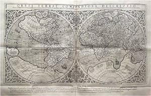
Soft cover. Zustand: Good. Engraved double-page double hemispheric world map with later hand coloring and in outline (Image: 11 1/4 x 20 1/2 in.; 28.6 x 52 cm; 16 1/2 x 22 in.; 41.9 x 55.9 cm), wide margins, Latin text on verso. BINDING/CONDITION: Floated on sturdy card stock and enclosed in mylar. Several cracks in plate eviden…t in cartouche. (65B1A) The present work is a reduced version of the 1569 wall map of the world, on which the Mercator Projection was introduced. In the western hemisphere on the left, the prominent bulge in South America, a characteristic introduced by Gerard Mercator and evident on his 1569 world map, has been retained here. Tierra del Fuego forms part of a gigantic southern continent that continues in the eastern hemisphere. At the north pole, two of the four islands that Gerard Mercator thought surrounded the pole are evident. There is also a suggestion of a Northwest Passage via the Straits of Anian. Anian derives from Ania, a Chinese province on a large gulf mentioned in Marco Polo's travels. The gulf Polo described was actually the Gulf of Tonkin, but the province's description was transposed from Vietnam to the northwest coast of North America. The first map showing the transposition was Giacomo Gastaldi's world map (1562), followed by Zaltieri and Mercator. The Strait thus became synonymous with the Northwest Passage, i.e., a passage to China. It appeared on maps until the 18th century. Quivira, south of Anian, refers to the Seven Cities of Gold sought by Spanish explorer Francisco Vasquez de Coronado in 1541. Although he never found these fabulous cities, the name remained on maps of southwest North America. In the eastern hemisphere, Japan appears as a large, round island. The islands of Southeast Asia are arrayed with relative accuracy for the time. To the south, the names of Beach, Maletur, and Lucach reveal again Mercator's use of toponyms from Marco Polo. REFERENCE: Shirley 157.

Verlag: Eustathius Vignon],
- Karte
Anbieter: Daniel Crouch Rare Books Ltd, London, Vereinigtes KönigreichDaniel Crouch Rare Books Ltd
Verkäufer/-in kontaktierenVerkäufer/-in mit 4 SternenZustand: Gebraucht
EUR 4.844,70
EUR 23,52 VersandVersand von Vereinigtes Königreich nach USAAnzahl: 1 verfügbar
A separately-published world map, issued prior to its inclusion in the first "atlas" to be so called First issue. Double-page folding engraved map, with no text beneath, nor on verso. This double-hemisphere map of the world is a reduced version of Gerard Mercator's revolutionary wall map of the world (1569), and was first publis…hed in Strabo's 'Geographicarum libr XVII', with text beneath the map headed "Lectori S.P.", and without text on the verso. It may have also been published separately, and in the final part of Mercator's atlas, before being included in Rumold Mercator's complete five-volume edition of the atlas from 1595. However, the Mercator family were beaten to the post, in popularizing (and capitalizing on) this modern world view, by Abraham Ortelius, who included it as a simplified single sheet map in his atlas of the world, 'Theatrum Orbis Terrarum' (1570). California shown as part of the mainland, there is the distinctive bulge in South America, and the kingdoms of Beach, Lucach and Maletur are shown as part of the mythical southern continent "Terra Australis", which is shown as an entirely separate landmass: it "wraps around the fullest expanse of the southern latitudes possible, save for New Guinea, which is correctly shown as a separate island. 'Terra Australis' has, in addition, become a dumping ground for errors. It harbours a realm of parrots, 'Psittacorum regio', and serves as the refuge for lands reported by Marco Polo but which have been displaced because they are now duplicated by more recent data. On the opposite pole, Mercator has depicted the Arctic according to the four-island theory previously used by Ruysch and Finaeus" (Suarez). The mapmaker Gerard Mercator (1512-1594) would not begin his great 'Atlas' or "Cosmography" until relatively late in life. The impetus for this came when he was employed as cosmographer to Duke William IV of Kleve, in 1563. Mercator's intention was to produce a work that consisted of five books and encompassed the whole world. The first book would cover the creation; the second the heavens; the third geography; the fourth history; and the fifth chronology. He intended to draw all the maps, write all the text and cut all the plates himself. Unsurprisingly, the ambitious project would require more time than he could afford to give it, and he was only able to complete a few of the parts: the creation; the maps for Ptolemy's 'Geographia' part of the geographical section in 1578; and four of the modern parts. The first three were published together in 1585 and included France, the Low Countries, and Germany. The fourth part, of Italy, the Balkans, and Greece, appeared in 1589. Mercator died on December 2, 1594, leaving the responsibility for completion of the cosmography to his son Rumold. A number of maps still had to be engraved, and he employed various members of the Mercator family as engravers, including Gerard's grandsons Gerard and Michel. Mercator's work is referred to as the first atlas, because he was the first to give a collection of curated maps this name, reflected in the famous engraved title-page showing King Atlas measuring the world with a pair of dividers. It is often wrongly thought that the word"atlas" refers to the Titan of the same name, whose punishment for fighting against the Olympian gods was to hold the heavens on his shoulders. It is instead a reference to King Atlas of the mythical Mauritania, a mathematician and philosopher who supposedly made the first celestial globe. Literature: Clancy, 'The Mapping of Terra Australis', 5.11, and page 70; Shirley, 'The mapping of the world: early printed world maps, 1472-1700', 157; Suarez, 'Shedding the Veil', 31.
Verlag: Antonii Magini c.1617, Arnhem, The Netherlands, 1617
- Karte
Anbieter: Alexandre Antique Prints, Maps & Books, Toronto, ON, KanadaAlexandre Antique Prints, Maps & Books
Verkäufer/-in kontaktierenVerkäufer/-in mit 4 SternenZustand: Gebraucht - Gut
EUR 1.080,57
EUR 5,25 VersandVersand von Kanada nach USAAnzahl: 1 verfügbar
Zustand: Very Good. Latin text and blank verso.Rare World map, taken from Ioannis Antonii Magini's Geographia Tum Veteris, Tum Nova. It is published in Arnhem in 1617 and edited by Jan Janssonius. The map is specially engraved for this publication by Abraham Goos, inspired by the map of Girolamo Porro of 1597, a reduction of the… Mercator globe., Size : 172x246 (mm), 6.77x9.69 (Inches), Black & White.
 Weitere Bilder
Strabonis Rerum Geographicarum Libri XVII. Isaacus Casabonus recensuit, summoque studio & diligentia, ope etiam veterum codicum, emendavit, ac Commentariis illustravit. Accessit & Tabula Orbis totius descriptionem complectens. Adiecta est etiam Guilielmi Xylandri Augustani Latina versio, cum necessariis Indicibus. [With ] Isaaci Casauboni Commentarius et Castigationes ad lib. Strabonis Geograph. XVII. S. l. First edition with the Mercator World Map .
Strabo (ca. 64 BCE - ca. 23 CE) ; Text by Isaac Casaubon (1559-1614); Map by Rumold Mercator (1559-1614) after Gerard Mercator (1512-1594)
Verlag: Geneva: Eustathius Vignon., 1587
- Erstausgabe
Anbieter: Wittenborn Art Books, San Francisco, CA, USAWittenborn Art Books
Verkäufer/-in kontaktierenVerkäufer/-in mit 5 SternenZustand: Gebraucht - Befriedigend
EUR 13.056,88
EUR 8,74 VersandVersand innerhalb von USAAnzahl: 1 verfügbar
Zustand: Good. Folio. 34 x 21 cm. Original contemporary stiff vellum with 6 raised bands. [2], viii, 602, [10], 224pp. Two columns printed in Latin and Greek in the first part and Latin only in the second part. Waterstain in the lower right corner throughout. The map is bound in front of page 1 and is in fine and fresh condition….This unique map was first printed as part of Isaac Casaubon's edition of Strabo's Geographia in 1587. In this, the first printing there are columns of text underneath rhe map with the heading, "Lectori S. P." In later editions the map was included in the well known Mercator atlas, which Rumold compiled. In 1603, the plate developed cracks in the top edge of the plate; two distinct cracks can be seen in the title.The preeminent example of Rumold Mercator's map of the world, first printed in this edition in Geneva in 1587. It is based on Gerard Mercator's celebrated 1569 world map and was made while Gerard was still alive (1512- 1594). This is the only collectible world map with direct input from Gerard Mercator, the greatest geographer of his era. Both his 1538 and 1569 world maps are unobtainable rarities.The present work is a reduced version of the 1569 wall map of the world, on which the revolutionary Mercator Projection was introduced. This edition makes the map into a double-hemisphere format, rather than the projection style.To the left is the western hemisphere. The prominent bulge in South America, a characteristic introduced by Gerard Mercator and evident on his 1569 world map, has been retained here. Tierra del Fuego forms part of a gigantic southern continent that continues in the eastern hemisphere. At the north pole, two of the four islands that Gerard Mercator thought surrounded the pole are evident. There is also a suggestion of a Northwest Passage via the Straits of Anian.Isaac Casaubon, (1559, Geneva ?died July 1, 1614, London). French classical scholar and theologian who was one of the leading scholars of the era.He was born in Geneva on 18th February 1559, a son of Huguenot parents Arnaud and Jeanne. He was educated at the university in his home town and taught Greek there. His first wife was Marie Prolyst but she and their daughter died. In 1586 in Geneva he married Florence, daughter of Henry Estienne and they had seventeen children, of whom about half did not survive infancy. His first major published work was on the Greek geographer Strabo and many other works followed. The invitation to come to England seems to have come from Richard Bancroft, Archbishop of Canterbury. Isaac was later made a prebendary of Canterbury but died in London on 1st July 1614.References: This first edition not in OCLC. Shirley, The Mapping of the World - Early Printed World Maps 1472 - 1700, Nr. 157; van der Krogt, Koeman's Atlantes Neerlandici, Vol. I, 0001:1A; Adams S-1908; Graesse VI:505. (Map) Koeman Me12; Moreland & Bannister p. 243; Shirley 157; Wagner Northwest Coast 146 . In-folio, reliure de l'époque vélin, dos à 6 nerfs, titre à l'encre dans le caisson de tête. Qq. taches, petites déchirures (nerfs et coiffe inférieure), coins usés. (8)-602-(2 bl.)-(8)-223 pp. et planisphère à double page rempliée. Trace de mouillure dans la partie inférieure droite sur tout l'ouvrage, marquée sur le premier quart puis s'amenuisant et s'estompant jusqu'à la fin du volume. Planisphère en belle condition (mouillure à peine visible, pas de déchirure, impression contrastée). Exemplaire complet des deux pages de titre gravées sur bois à décor identique de cariatides soutenant une couronne et de la planisphère (Orbis Terrae Compendiosa Descriptio) gravée par Rumold Mercator d'après la carte de son père Gérard Mercator et légendée en latin.Expertise by Christine CHATON Expertise en livres anciens et modernes (C.N.E.S.), 17100 SAINTES.
Strabonis Rerum Geographicarum Libri XVII. Isaacus Casaubonis Recensuit, Summoque Studio & Diligentia, Ope Etiam Veterum Codicum, Emendauit, Ac Commentariis Illustrauit.
STRABO (64/63 B.C.-ca. 25 A.D.) - CASAUBON, Isaac (1559-1614) - MERCATOR, Gerard (1512-1594) - MERCATOR, Rumold (1545-1599).
Verlag: Eustathius Vignon, Geneva, 1587
- Erstausgabe
Anbieter: Arader Galleries - AraderNYC, New York, NY, USAArader Galleries - AraderNYC
Verkäufer/-in kontaktierenVerkäufer/-in mit 5 SternenZustand: Gebraucht
EUR 15.308,06
Versand nach gratisVersand innerhalb von USAAnzahl: 1 verfügbar
1st Edition. Two parts in one, volume. Folio (13 4/8 x 8 4/8 inches). Titles within historiated woodcut borders, printed in Greek and Latin in double columns, engraved double-page double-hemispherical world map: Mercator's "Orbis Terrae Compendiosa Descriptio", Geneva 1587 (13 ¼ x 20 ¼ inches) (supplied, small marginal tear just… affecting the image repaired on verso), (some pale marginal dampstains, and one or two wormstracks). 19th-century red paneled morocco antique, spine in five compartments with four raised bands, an 18th-century morocco lettering piece in one (extremities, front paste-down removed, endpapers stained). Provenance: Contemporary marginal annotations to Casaubon's commentary, and a leaf of manuscript notes at the end. First edition of Isaac Casaubon's famous edition of Strabo's "Geography", one of the earliest and most important scientific treatises of historical geography, containing the FIRST APPEARANCE OF MERCATOR'S CELEBRATED AND ONLY AVAILABLE WORLD MAP "Orbis Terrae Compendiosa Descriptio" Geneva 1587. This variant without text on the verso and with Latin text in the bottom margin. "Gerard Mercator's great world map of 1569 was condensed into double hemispherical form by his son Rumold. The engraving is a model of clarity and neatness, with typical cursive flourishes to the lettering of the sea names." (Shirley). This map was later incorporated in Mercator's influential atlas of 1595. Adams S-1908; Graesse VI:505. (Map) Koeman Me12; Moreland & Bannister p. 243; Shirley 157; Wagner Northwest Coast 146.
Verlag: [Geneva:] Rumold Mercator, 1587 (but Amsterdam:, Jocodius Hondius, Ca 1620., 1620
Anbieter: Arader Galleries - AraderNYC, New York, NY, USAArader Galleries - AraderNYC
Verkäufer/-in kontaktierenVerkäufer/-in mit 5 SternenZustand: Gebraucht
EUR 25.213,28
Versand nach gratisVersand innerhalb von USAAnzahl: 1 verfügbar
Single sheet, float mounted and framed (11 2/8 x 20 4/8 inches to the neat line). Fine engraved double-hemisphere map of the world set within an elaborate strapwork border with an armillary sphere and a compass rose in the cusps, all with original hand-colour in full (side margins renewed, one or two other repairs). THE FIRST DO…UBLE-HEMISPHERE MAP OF THE WORLD. This striking map represents a re-working of Mercator's great world map of 1569 by his son and successor Rumold, who transformed it into double-hemispherical form in 1587 and incorporated it into editions of Mercator's influential atlas from 1595. This issue dates from the 1620s as the break marks at the top of the copper plate now extend through the title. Showing New Guinea as an island and Beach as a peninsula of Terra Australis. The engraving is a model of clarity and neatness, with typical cursive flourishes to the lettering of the sea names. Surrounding the hemispheres is a strapwork border, while between them at the top margin is an armillary sphere and at the bottom an elaborate compass rose. Gerard Mercator's prominent south-west bulge on the coastline of South America, which was soon to be corrected, is retained. This superb map represents a seminal moment in the history of cartography, for it was the primary instrument by which knowledge of Mercator's projection was diffused throughout Europe. Shirley 157. Catalogued by Kate Hunter.
 Weitere Bilder
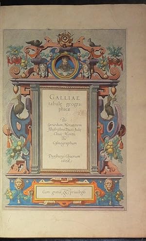
Galliae Tabule Geographicae. -- Belgii Inferiores Geographicae Tabule -- Germaniae Tabule Geographicae - Italiae, Sclavoniae, et Graecie
MERCATOR, Gerard (1512-1594) and MERCATOR Rumold (ca 1545-1599).
Verlag: Duisburg: [1585 - 1589]., 1589
Anbieter: Arader Galleries - AraderNYC, New York, NY, USAArader Galleries - AraderNYC
Verkäufer/-in kontaktierenVerkäufer/-in mit 5 SternenZustand: Gebraucht
EUR 14.407,59
Versand nach gratisVersand innerhalb von USAAnzahl: 1 verfügbar
Folio (15 x 11 inches). Dedication dated 1585. Frontispiece portrait of Mercator by Hogenberg dated 1574 (preliminaries quite loose), four engraved title-pages with broad and elaborate allegorical borders with classical and mannerist motifs (the first remargined at an early date and with later insect damage) and 59 fine double-p…age engraved maps (of 73, without from part one: Gallia, Britannia & Normandia, Aquitania, France Picardie, Poictou; from part II: Belgii Inferioris; part III: Germania, Austria Archiducatus; part IV: Italia, Forum Iulium, Tuscia, Marchia Anconitana, and Morea), and one single page, all with fine contemporary hand-color, descriptive letterpress on the recto of each map, each verso blank, woodcut initials (some marginal waterstaining, a few maps with brittle areas caused by oxidation, one or two early repairs to versos). Early full sheep with large arabesque design in blind and lettered "Atlas 1745" on each cover (quite worn, with the remains of two pairs of silk ties). Provenance: with the 18th-century ownership inscriptions of J.I. Becker, "pastoris", 1760 and W.W. Wolff, "vicarii", 1761, above the portrait of Mercator; ink library stamp of Schloss Rimburg, Aachen, on the front paste-down; Swann Galleries, 5th December, 2013, lot 101 The Mercator firm's earliest collection of modern maps, first issued in 1585 by Gerard Mercator, initially issued separately or combined with the second part "Italia" published in 1589. Mercator was born in Rupelmonde in East Flanders. He studied in Louvain under Gemma Frisius, a Dutch astronomer and mathematician, and began his career as a cartographer in that city, where the excellence of his work eventually won him the patronage of Charles V. In order to escape religious persecution, he moved in 1552 to Duisburg. There, he continued to produce maps, globes and instruments, including his most celebrated work, a world map on eighteen sheets drawn to his new projection (1569). In later life he devoted himself to the preparation of his three-volume collection of maps to which, for the first time, the word "atlas" was applied. The word was chosen, he wrote, "to honor the Titan, Atlas, King of Mauritania, a learned philosopher, mathematician, and astronomer." Mercator's sons and grandsons were all cartographers and made their contributions in various ways to the great atlas. His son Rumold, in particular, was responsible for the complete edition of 1595. Koeman Me 9 and Me 11. Catalogued by Kate Hunter.
 Weitere Bilder
Galliae Tabule Geographicae. -- Belgii Inferiores Geographicae Tabule -- Germaniae Tabule Geographicae.
MERCATOR, Gerard (1512-1594) and MERCATOR Rumold (ca 1545-1599).
Verlag: Duisburg: [not after 1595]., 1595
Anbieter: Arader Galleries - AraderNYC, New York, NY, USAArader Galleries - AraderNYC
Verkäufer/-in kontaktierenVerkäufer/-in mit 5 SternenZustand: Gebraucht
EUR 76.540,32
Versand nach gratisVersand innerhalb von USAAnzahl: 1 verfügbar
Folio (16 2/8 x 11 2/8 inches). Three engraved title-pages (the first with early abrasion where ownership inscription has been erased) and 50 fine double-page engraved maps, and one full page, all with fine contemporary hand-color, descriptive letterpress on the recto of each map, each verso blank, woodcut initials, single blank… leaves bound in before the first maps in the Netherlands (Belgii) and Germany sections (last map of Hungary, with early hot wax stains to verso affecting the image). Contemporary limp vellum, yapp fore-edges, title in manuscript on the spine, map of Germany with symetrical closed marginal tears, extending 4 inches into the image). Provenance: early marginal note to +v. Mercator's earliest collection of modern maps, first issued in 1585 by Gerard Mercator, initially issued separately or combined with the second part "Italia" published in 1589. This copy conforms with Koeman's collation for the issue of the three parts as they were published as part of the first Mercator atlas "Atlas sive Cosmographicae", 1595, issue A [Koeman Me13A], although this copy does not include the portrait and has the dedication dated 1585. Koeman argued that the resetting of the text was indicative of the later 1595 issues. Other authorities have argued against this hard and fast rule. The uncolored copy in the Nordenskiold Collection [Nordenskiold 2, 138] conforms broadly to this copy, although with its later binding may well have been taken from a 1595 issue of the larger atlas. It is highly likely, given the popularity of Mercator's work, that the stocks of the 1585 issue ran out before Mercator's death in 1594. Gerard Mercator was paralysed by a stroke in 1590, and the existence of this atlas in its contemporary binding suggests that Gerard or Rumold had the text reset well in advance of the completion of the full atlas, and had continued to sell the three parts as a single volume. Mercator was born in Rupelmonde in East Flanders. He studied in Louvain under Gemma Frisius, a Dutch astronomer and mathematician, and began his career as a cartographer in that city, where the excellence of his work eventually won him the patronage of Charles V. In order to escape religious persecution, he moved in 1552 to Duisburg. There, he continued to produce maps, globes and instruments, including his most celebrated work, a world map on eighteen sheets drawn to his new projection (1569). In later life he devoted himself to the preparation of his three-volume collection of maps to which, for the first time, the word "atlas" was applied. The word was chosen, he wrote, "to honor the Titan, Atlas, King of Mauritania, a learned philosopher, mathematician, and astronomer." Mercator's sons and grandsons were all cartographers and made their contributions in various ways to the great atlas. His son Rumold, in particular, was responsible for the complete edition of 1595. Koeman Me13A. Catalogued by Kate Hunter.


