Gesamtpreis (1 Artikel Artikel):
Versandziel:

ross captain (22 Ergebnisse)
Direkt zu den wichtigsten Suchergebnissen
Suchfilter
Produktart
- Alle Product Types
- Bücher (21)
- Magazine & Zeitschriften (Keine weiteren Ergebnisse entsprechen dieser Verfeinerung)
- Comics (Keine weiteren Ergebnisse entsprechen dieser Verfeinerung)
- Noten (Keine weiteren Ergebnisse entsprechen dieser Verfeinerung)
- Kunst, Grafik & Poster (Keine weiteren Ergebnisse entsprechen dieser Verfeinerung)
- Fotografien (Keine weiteren Ergebnisse entsprechen dieser Verfeinerung)
- Karten (1)
- Manuskripte & Papierantiquitäten (Keine weiteren Ergebnisse entsprechen dieser Verfeinerung)
Zustand Mehr dazu
Einband
Weitere Eigenschaften
- Erstausgabe (2)
- Signiert (Keine weiteren Ergebnisse entsprechen dieser Verfeinerung)
- Schutzumschlag (3)
- Angebotsfoto (11)
Sprache (2)
Gratisversand
- Kostenloser Versand nach USA (Keine weiteren Ergebnisse entsprechen dieser Verfeinerung)
Land des Verkäufers
Verkäuferbewertung
-
Fifty-First in France
Anbieter: Ria Christie Collections, Uxbridge, Vereinigtes Königreich
Verkäuferbewertung 5 von 5 Sternen

EUR 19,86
EUR 13,98 Versand
Versand von Vereinigtes Königreich nach USAAnzahl: Mehr als 20 verfügbar
In den WarenkorbZustand: New. In.
-

A SHOWER OF SPRAY AND WE'RE AWAY
Sprache: Englisch
Verlag: Reed, Wellington, 1971
Anbieter: Global Village Books, Bundall, QLD, Australien
Verkäuferbewertung 4 von 5 Sternen

Hardcover. Zustand: Good. Zustand des Schutzumschlags: Good. First Edition. Original Cloth. Good Plus/Good Plus. First Edition. 234pp. B&w pls. Near vg in like dj. Amphibious aircraft in New Zealand. Size: 8vo.
-

Light and Shade in War
Anbieter: Ria Christie Collections, Uxbridge, Vereinigtes Königreich
Verkäuferbewertung 5 von 5 Sternen
EUR 25,03
EUR 13,98 Versand
Versand von Vereinigtes Königreich nach USAAnzahl: Mehr als 20 verfügbar
In den WarenkorbZustand: New. In.
-

Representative Government and War
Verlag: Hutchinson & Co., 1903
Anbieter: World of Rare Books, Goring-by-Sea, SXW, Vereinigtes Königreich
Verkäuferbewertung 5 von 5 Sternen
EUR 21,95
EUR 5,63 Versand
Versand von Vereinigtes Königreich nach USAAnzahl: 1 verfügbar
In den WarenkorbZustand: Fair. 1903. No Edition Remarks. 384 pages. No dust jacket. Red cloth with gilt lettering. Missing front free endpaper. Light foxing and tanning to pages. More prominent to text block edges, pastedowns, title pages and rear free endpaper. Moderate cracking to gutters causing some looseness to binding but pages remain attached; cracking lighter to hinges. Boards have minor corner bumping and edgewear with mild tanning and scuffing overall. Spine has heavier tanning with soft crushing to ends. Lettering remains bright and clear. Book has a slight forward lean.
-

Light and Shade in War
Anbieter: Ria Christie Collections, Uxbridge, Vereinigtes Königreich
Verkäuferbewertung 5 von 5 Sternen
EUR 34,73
EUR 13,98 Versand
Versand von Vereinigtes Königreich nach USAAnzahl: Mehr als 20 verfügbar
In den WarenkorbZustand: New. In.
-
Narrative of a Voyage by Captain Ross in the Years 1829, 30, 31, 32, and 33, to discover a North-West Passage from the Eastern to the Western Ocean; in which is given detailed particulars of the many unparallelled sufferings experienced by himself and his undaunted crew, during his abode in those extremely inclement regions; the loss of the Victory steam ship; the discovery of the North Pole; and the rescue of Captain Ross and his crew by the Isabella, a whale ship from Hull, by which they safely returned to their native country. Embellished by a highly finished engraving.
Verlag: London, William Mason, 1835 [original edition]. K Book Editions, York, England. "This book has been reproduced from a copy held in the special collection on Whaling of the Kingston upon Hull City Libraries, Hull, England.", 1835
Anbieter: Grant's Bookshop, Cheltenham, VIC, Australien
Verkäuferbewertung 4 von 5 Sternen
Octavo, 24pp, folding facsimile engraving of 'Captain Ross's voyage to the North Pole', original boards, a small bookplate, a near fine copy. Facsimile edition.
-
THE SEVENTEENTH BRIGADE MAGAZINE. A Record of Four Years Campaigning.
Verlag: np., 17 Australian Infantry Brigade nd. [c.1944]., 1944
Anbieter: Grant's Bookshop, Cheltenham, VIC, Australien
Verkäuferbewertung 4 von 5 Sternen
144pp. 4to. Original stiffened wrappers, light wear to extremities, slight bend in upper wrapper. Black and white prints and maps. A very good copy.
-

A Voyage of Discovery and Research in the Southern and Antarctic Regions During The Years 1839-43. (Volume Two only)
Anbieter: Glacier Books, Pitlochry, Vereinigtes Königreich
Verkäuferbewertung 4 von 5 Sternen
EUR 43,29
EUR 17,51 Versand
Versand von Vereinigtes Königreich nach USAAnzahl: 1 verfügbar
In den Warenkorbhardcover. 1969 rep. xiii, 447pp, folding maps and panoramas, original blue cloth, some speckling to cloth as is often the case with this title, VG in VG dw with sunning to spine. When Captain James Ross sailed from England in command of HMS Erebus and HMS Terror in 1839, practically nothing was known of the great Antarctic continent. Glacier Books are experienced and professional booksellers. We take pride in offering carefully described books and excellent customer service.
-
Fifty-First in France
Anbieter: Ria Christie Collections, Uxbridge, Vereinigtes Königreich
Verkäuferbewertung 5 von 5 Sternen
EUR 47,56
EUR 13,98 Versand
Versand von Vereinigtes Königreich nach USAAnzahl: Mehr als 20 verfügbar
In den WarenkorbZustand: New. In.
-
Ross, Captain John (1777-1856), Scottish Artic Explorer - an Original Antique Engraved Portrait
Sprache: Englisch
Verlag: Chatto & Windus, London, 1898
Anbieter: K Books Ltd ABA ILAB, York, YORKS, Vereinigtes Königreich
Verbandsmitglied: ABA ILAB PBFA
Verkäuferbewertung 5 von 5 Sternen
EUR 24,05
EUR 22,76 Versand
Versand von Vereinigtes Königreich nach USAAnzahl: 1 verfügbar
In den WarenkorbNo Binding. Zustand: Very Good. A splendid Victorian tinted litho portrait. From Maclise originals published between 1830-1838, these reprints were published in 1898. Mounted and ready to frame. "Author of 'Voyage to Baffin's Bay'" is written underneath this fine characteristic portrait of Ross sitting at the hearth with pipe and drink in hand, with printed signature.
-
The Fifty-First in France.
Verlag: London. Hodder and Stoughton. 1st Edition 1918, 1918
Anbieter: WORLD WAR BOOKS, TUNBRIDGE WELLS, Vereinigtes Königreich
Verbandsmitglied: PBFA
Verkäuferbewertung 5 von 5 Sternen
Erstausgabe
EUR 33,67
EUR 15,00 Versand
Versand von Vereinigtes Königreich nach USAAnzahl: 1 verfügbar
In den WarenkorbHardcover. Zustand: Very Good. F. Interesting first hand account of the 51st Division on the Western Front in WWI, well illustrated with pen and ink sketches. 313pp., ills., Very minor blemishes, otherwise very good condition.
-
![Bild des Verkäufers für The Boers and the Cause of the War in South Africa [microform] zum Verkauf von AHA-BUCH GmbH](https://pictures.abebooks.com/inventory/md/md31915326618.jpg)
The Boers and the Cause of the War in South Africa [microform]
Sprache: Englisch
Verlag: Creative Media Partners, LLC Sep 2021, 2021
ISBN 10: 1015360157 ISBN 13: 9781015360150
Anbieter: AHA-BUCH GmbH, Einbeck, Deutschland
Verkäuferbewertung 5 von 5 Sternen
Taschenbuch. Zustand: Neu. Neuware - This work has been selected by scholars as being culturally important and is part of the knowledge base of civilization as we know it.
-
Captain Ross, John (1777-1856)- An Original Antique Black & White Sketch
Sprache: Englisch
Verlag: Frasers Magazine, 1880
Anbieter: K Books Ltd ABA ILAB, York, YORKS, Vereinigtes Königreich
Verbandsmitglied: ABA ILAB PBFA
Verkäuferbewertung 5 von 5 Sternen
EUR 42,08
EUR 22,76 Versand
Versand von Vereinigtes Königreich nach USAAnzahl: 1 verfügbar
In den WarenkorbNo Binding. Zustand: Very Good. Daniel MacLise (illustrator). An attractive black and white charactersitic sketch of an eminent author. This is an excellent opportunity to purchase this splendid original print. Arctic explorer of Baffin's Bay fame.
-

Light and Shade in War
Sprache: Englisch
Verlag: Creative Media Partners, LLC Jul 2023, 2023
ISBN 10: 1022043595 ISBN 13: 9781022043596
Anbieter: AHA-BUCH GmbH, Einbeck, Deutschland
Verkäuferbewertung 5 von 5 Sternen
Taschenbuch. Zustand: Neu. Neuware - Captain Malcolm Ross served in the First World War and describes his experiences with candor and humor in this captivating memoir.
-

Light and shade in war
Verlag: Edward Arnold, UK, 1916
Anbieter: Book Express (NZ), Shannon, Neuseeland
Verkäuferbewertung 4 von 5 Sternen
Hardcover. Zustand: Good. good order -cloth still reasonably bright-gilt work not faded.
-
A Voyage of Discovery and Research in the Southern and Antarctic Regions, during the Years 1839-43,
Sprache: Englisch
Verlag: John Murray, London, 1847
Anbieter: Back Lane Books, North Vancouver, BC, Kanada
Verbandsmitglied: IOBA
Verkäuferbewertung 5 von 5 Sternen
Hardcover. Zustand: Very Good. A Voyage of Discovery and Research in the Southern and Antarctic Regions, during the Years 1839-43, Captain Sir James Clark Ross. Published by John Murray, London, Undated, Circa 1847. 2 volumes. Volume I: lii, 366 pp. Volume II: [vii]-x, 447 pp. with in text illustrations, plates and maps; folding map to each volume at rear; folding plate in Volume 1. Quarter leather over brown textured cloth, all edges red. Front boards detached in Volume 1; inner hinges lightly weakened; foxing to preliminaries; leather spines very rubbed. Library labels to front boards are from the well-respected Lovejoy and Southern Counties Circulating Library, 37 and 38 London Street, Reading. At the time, Lovejoy's library was reputedly the largest private circulating library in England outside London. The bookshop and library were continued after Lovejoy's death by Eliza Langley, his assistant of 21 years; her name appears on these labels. This 1847 account by Sir James Clark Ross, documents his groundbreaking expedition with HMS Erebus and Terror which resulted in the discovery of the Ross Sea, the Ross Ice Shelf, and Victoria Land. The expedition had a major scientific impact: it identified the approximate location of the South Magnetic Pole and provided extensive oceanographic, magnetic, and geological data.
-
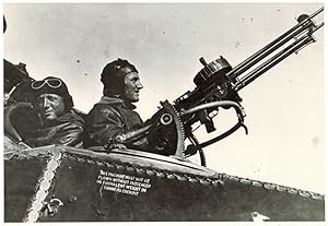
PHOTOGRAPH of Ross Smith in cockpit of Bristol F.2 B Fighter Plane with gunner Mustard.
Verlag: Taken in 1917, but later printing. 6.75in x 9.75in, 1917
Anbieter: R.G. Watkins Books and Prints, Ilminster, SOMER, Vereinigtes Königreich
Verkäuferbewertung 5 von 5 Sternen
EUR 24,05
EUR 32,69 Versand
Versand von Vereinigtes Königreich nach USAAnzahl: 1 verfügbar
In den WarenkorbRoss shot down 11 enemy planes, and finished his service as AustraliaŐs most decorated WWI pilot. He is mentioned several times in Lawrence's book, 'Seven Pillars of Wisdom'.
-
Light and Shade in War
Verlag: Edward Arnold, London, 1916
Anbieter: Renaissance Books, ANZAAB / ILAB, Dunedin, Neuseeland
Verkäuferbewertung 5 von 5 Sternen
Hardcover. Zustand: Very Good-. Zustand des Schutzumschlags: No Dust Jacket. No signatures. Spine faded. Moderate spotting to top page edges. A couple of small stains to top page edges. Minor rubbing to edges of spine and boards. Tissue guard to frontis present. Gutters intact at hinges. ; Second impression. x, [2], 271, [3] pages + [2] pages advertisements + frontis + 11 illustrations on 7 leaves. Black titles on spine and front board. Gilt sunrise (or sunset?) illustration on front board. "Most of these sketches were written whilst the scenes and incidents they depict were fresh in the mind; some under fire. The proofs were corrected on the battlefield of the Somme in a tent over which British and German shells were passing at the time." - from the preface. ; 12mo.
-

A Voyage of Discovery and Research in the Southern and Antarctic Regions During the Years 1839-43 (In 2 Volumes)
Verlag: Augustus M. Kelley, New York, 1969
Anbieter: APPLEDORE BOOKS, ABAA, WACCABUC, NY, USA
Verkäuferbewertung 5 von 5 Sternen
Cloth. Zustand: Near Fine. Zustand des Schutzumschlags: Near Fine. A very sharp example of the 1969 reprint --complete in 2 volumes-- of the 1847 original printings, published originally by John Murray of London and here re-done by Augustus M. Kelley of New York. Both volumes in this handsome re-issue clean and Near Fine in crisp, Near Fine dustjackets, with one very small closed tear along volume 1's top-edge. Thick octavos, Foreword by Sir Raymond Priestley. Fold-out plates in each volume, several dozen maps and plates complementing Captain Ross's text. Vol. 1: August 1839-April '41; Vol. 2: April 1841-September '43.
-

Representative Government and War.
Erscheinungsdatum: 1903
Anbieter: Henry Sotheran Ltd, London, Vereinigtes Königreich
Verbandsmitglied: ABA ILAB PBFA
Verkäuferbewertung 5 von 5 Sternen
Erstausgabe
EUR 156,31
EUR 46,69 Versand
Versand von Vereinigtes Königreich nach USAAnzahl: 1 verfügbar
In den WarenkorbLondon, Hutchinson, 1903. 8vo. Original red buckram, spine lettered in gilt, top edge gilt; pp. viii, 384; cloth a little faded, bookealer's annototations in pencilt to endpapers, otherwise very good.First edition, rare. Having experienced the Boer War and the political ramifications back in Britain, Ross published this study of the volatile geopolitics of Europe at te time and hwo governments react.
-
China Sea - Sheet I [and] Sheet II To Capt. D. Ross and His Assistants Lieut. P. Maugham, J. Crawford, and J. Houghton, of the Bombay Marine; Who under the auspices of the Hon.ble East India Company, having performed with Arduous Zeal a difficult and dangerous Exploration of the China Sea, so Essential to the safety of Navigation, This Chart - Although with an extension of Limits being Chiefly Construction from Their Valuable Surveys, is now Inscribed as a Tribute due to Those Laudable Exertions By their Sincerely Obliged Friend, James Horsburgh.
Verlag: James Horsburgh, Hydrographer to the Hon.ble East India Company, October 1st, 1821. with Additions to 1846 [but 1849 - and -] 1 Feb.y 1823,. Additions to 1850., London,, 1821
Anbieter: Daniel Crouch Rare Books Ltd, London, Vereinigtes Königreich
Verbandsmitglied: ABA ILAB PBFA
Verkäuferbewertung 4 von 5 Sternen
Karte
EUR 3.486,90
EUR 23,35 Versand
Versand von Vereinigtes Königreich nach USAAnzahl: 1 verfügbar
In den WarenkorbThe best route towards China for leaky crazy ships during the strength of the S.W. Monsoon Two engraved charts, laid down on linen. Exceptionally detailed, large-scale charts of parts of Southeast Asia and the China Sea, including Singapore, Malay, Borneo, Cambodia, Cochin- China, Hainan, southeast China, Taiwan, and Luzon in the Philippines. The chart boldly indicates the "best" sea-routes to and from Batavia to China, depending on the season, and the condition of the vessel. "The best route towards China for leaky crazy ships during the strength of the S.W. Monsoon" plots a course that hugs the shores of the Malay Peninsula and Cambodia. The islands of the "Sincapour Strait", including "Sincapour", in shown in great detail, with numerous depth soundings, and coastal profiles. Printed updates, to the location of dangerous shoals in particular, appear to 1849. The current charts were first published in 1821 and 1823, respectively, as part of a plan to monetize his experience by producing a series of charts of the China Sea, Malacca Strait, and Bombay Harbour. Touchingly, the lower sheet shows the "Pedro Branco Light" that was built as a commemoration to Horsburgh upon his death in 1836, at the eastern entrance to the Strait of Singapore. The map is dedicated to Captain Daniel Ross (1780-1849) and his team of hydrographers of the Bombay Marine. In 1807, Ross was tasked by the East India Company to survey the China Seas. He spent nine years surveying the coast between 1807 and 1816, and then spent a further four years charting the seas between 1816 and 1820. On his return to England in 1821 he was rewarded with a cash sum of Ł1,500 from the East India Company, for his tireless work out in the Far East. He would later appear before a government Select Committee investigating the possibilities of increasing the Britain's trade with China. With the tracks of many voyages from the Singapore Strait to Canton, and then on to Manila, plotted, and annotated in the same hand, in pen and different coloured ink, dated: 1856, 1858, 1859, 1860, and 1864. Provenance: With the tracks of many voyages from the Singapore Strait to Canton, and then on to Manila, plotted, and annotated in the same hand, in pen and different coloured ink, dated: 1856, 1858, 1859, 1860, and 1864.
-
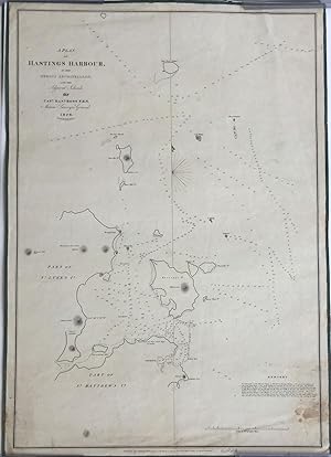
A Plan of Hastings Harbour, in the Mergui Archipelago, and the Adjacent Islands, by Capt. Danl. Ross, F.R.S. Marine Surveyor General 1828
Verlag: James Horsburgh, London, 1829
Anbieter: Antipodean Books, Maps & Prints, ABAA, Garrison, NY, USA
Verbandsmitglied: ABAA ANZAAB ESA ILAB
Verkäuferbewertung 4 von 5 Sternen
Maps. Zustand: Otherwise very good condition. A rare map of islands in the Andaman Sea, Burma, surveyed by Daniel Ross, known as the "Father of the Indian Surveys." Captain Ross was engaged in surveying the coast of China from 1806-1820. His highly accurate & trigonometrical charts were published as they were completed, and the whole were incorporated into Horsburgh's general charts. In 1823, he became the Marine Surveyor General. Clements Markham, in "A Memoir on the Indian Surveys" (1871) stated that "During the Burmese War from 1823 to 1826 the useful operations under his superintendency were interrupted." and despite a "fit of ruinous economy" in 1828, Ross resumed his good work and in 1830, again had two brigs (surveying) in the Mergui Archipelago. The map was surveyed on the heels of the First Burmese War, perhaps with thoughts of being prepared for another war, and another, which fortunately did not start again until the 1850s. The map shows the islands Hasting's, St. Matthew's and St. Luke's, now named Hastings, Zadetkalay and Zadetkyi. Other islands include Pine Tree, Russell's, Three Hill, Phipp's, Barwell's and Horse Shoe Island, mostly appearing as Kawthaung on Google maps. James Horsburgh (1762 -1836) was a Scottish hydrographer who worked for the British East India Company and charted much of South East Asia in the late 18th and early 19th centuries. When he retired from the sea in 1806, he produced a Sailing Directory to the East and in 1810 was appointed as hydrographer to the East India Company where he revised the Directory, publishing editions in 1816-7, 1826-7, and 1836. After his death the Admiralty took up the Directory and released editions in 1841, 1852, 1855, and 1864. his charts eventually passed to the Admiralty Hydrographic Office who also reissued them. Sea chart backed on linen and edged in blue silk, 19 1/2 x 22". Some spotting in the lower right corner (water) but otherwise remarkable clean and fresh, including the silk ties. "Engraved by Richard Bateman" beneath the title. The British Library holds a copy (BLL01004857047) but not noted on OCLC.


![Bild des Verkäufers für China Sea - Sheet I [and] Sheet II To Capt. D. Ross and His Assistants Lieut. P. Maugham, J. Crawford, and J. Houghton, of the Bombay Marine; Who under the auspices of the Hon.ble East India Company, having performed with Arduous Zeal a difficult and dangerous Exploration of the China Sea, so Essential to the safety of Navigation, This Chart - Although with an extension of Limits being Chiefly Construction from Their Valuable Surveys, is now Inscribed as a Tribute due to Those Laudable Exertions By their Sincerely Obliged Friend, James Horsburgh. zum Verkauf von Daniel Crouch Rare Books Ltd](https://pictures.abebooks.com/inventory/md/md31133266231.jpg)