Gesamtpreis (1 Artikel Artikel):
Versandziel:

rosaccio (29 Ergebnisse)
Direkt zu den wichtigsten Suchergebnissen
Suchfilter
Produktart
- Alle Product Types
- Bücher (14)
- Magazine & Zeitschriften (Keine weiteren Ergebnisse entsprechen dieser Verfeinerung)
- Comics (Keine weiteren Ergebnisse entsprechen dieser Verfeinerung)
- Noten (Keine weiteren Ergebnisse entsprechen dieser Verfeinerung)
- Kunst, Grafik & Poster (Keine weiteren Ergebnisse entsprechen dieser Verfeinerung)
- Fotografien (Keine weiteren Ergebnisse entsprechen dieser Verfeinerung)
- Karten (15)
- Manuskripte & Papierantiquitäten (Keine weiteren Ergebnisse entsprechen dieser Verfeinerung)
Zustand Mehr dazu
- Neu (4)
- Wie Neu, Sehr Gut oder Gut Bis Sehr Gut (3)
- Gut oder Befriedigend (4)
- Ausreichend oder Schlecht (Keine weiteren Ergebnisse entsprechen dieser Verfeinerung)
- Wie beschrieben (18)
Einband
Weitere Eigenschaften
- Erstausgabe (3)
- Signiert (3)
- Schutzumschlag (Keine weiteren Ergebnisse entsprechen dieser Verfeinerung)
- Angebotsfoto (24)
Sprache (2)
Gratisversand
Land des Verkäufers
Verkäuferbewertung
-
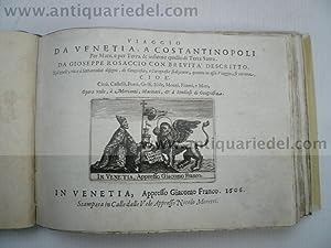
Viaggio Da Venetia, a Costantinopoli Per Mare, E Per Terra and Insieme Quello Di Terra Santa
Anbieter: PBShop.store UK, Fairford, GLOS, Vereinigtes Königreich
Verkäuferbewertung 5 von 5 Sternen

EUR 17,78
EUR 4,79 Versand
Versand von Vereinigtes Königreich nach USAAnzahl: 15 verfügbar
In den WarenkorbPAP. Zustand: New. New Book. Shipped from UK. Established seller since 2000.
-
Viaggio da Venezia a Costantinopoli
Anbieter: libreriauniversitaria.it, Occhiobello, RO, Italien
Verkäuferbewertung 4 von 5 Sternen

Zustand: NEW.
-
Viaggio da Venezia a Costantinopoli
Anbieter: Revaluation Books, Exeter, Vereinigtes Königreich
Verkäuferbewertung 5 von 5 Sternen
EUR 20,66
EUR 11,52 Versand
Versand von Vereinigtes Königreich nach USAAnzahl: 1 verfügbar
In den WarenkorbPaperback. Zustand: Brand New. Italian language. 9.37x6.46x0.47 inches. In Stock.
-

EUR 21,03
EUR 48,99 Versand
Versand von Deutschland nach USAAnzahl: Mehr als 20 verfügbar
In den WarenkorbZustand: New. KlappentextrnrnThis is a reproduction of the original artefact. Generally these books are created from careful scans of the original. This allows us to preserve the book accurately and present it in the way the author intended. Since the origina.
-
Le sei etŕ del mondo, Di Gioseppe Rosaccio, con brevitŕ descritte. Cioč{ Della creatione del Cielo, & della Terra. Di Adamo, & suoi descendenti. Del Diluuio, & suo tempo. Del nome delle genti, & loro origine. Delle Monarchie, e quanto tempo durarono. Della Natiuitŕ di Christo, & sua morte. Delle vite de i Papi, & altri Principi, con tutto quello che č successo fino all' Anno M. D. XCVIII
Verlag: [Domenico Farri], Venice, 1598
Erstausgabe Signiert
Paperback. Zustand: Good. Venice: [Domenico Farri,] 1598. Sexagesimo (16mo; 5 ˝" x 3 ľ", 139mm x 95mm). [Full collation available.] With a woodcut world map on the title-page signed "GIOSEPPE ROSATIO F/1590 " within the block. Simply sewn. All edges of the text-block speckled in blue. Splits along the spine, some repaired; quite tender. Generally soiled, with some damp-staining at the very fore-corners. Témoins to the upper fore-corners of A5-9 and to the lower fore-corner of B15. Worming to the lower margin of A12-B2, not affecting the text. "Accn. No. 22" in graphite to the title-page. Ink and graphite marginal calculations of date to pp. 16, 23 and 47. Ink marginalium in an old hand to p. 45, noting the murder of Henri III of France. Presented with a shipping envelope postmarked 1928 and a storage envelope. Chronicles as a form of history date back to the early Roman period at least, although the name is Greek (from ???????, chronica, timely things). They take date as their guiding principle, and often reflect larger divisions such as ages (the etŕ of the title) -- conventionally divided into six by Augustine of Hippo in his De catechizandis rudibus of ca. AD 400 -- divided according to major events such as the Deluge or the birth of Christ. It is commonly misunderstood that the chronicle is an undeveloped form of history, but Herodotus and Thucydides handily beg the question. Chronicles allow for the rigorous alignment of history in a world about which knowledge in Europe grew steadily from 1500. Thus Giuseppe Rosaccio (ca. 1530-1620) used this format in the closing decade of the XVIc to make this little handbook, drawing on more than forty authorities listed before the dedication. The first five ages take just 10 pages at the beginning of the text, the rest tracing the lives of the popes and other princes (inter alia) up to 1598. Rosaccio's work by this title was first published 1593, but as this is a living chronicle -- continually updated rather than ending on first composition -- each subsequent edition or issue naturally contains new material. Editions were printed in Brescia, Milan, Bologna, Florence and Ferrara before the first Venetian edition of 1595, and continued to be produced into early 1600's. A world map appears first in 1594 (Bologna: Rossi) but is far less detailed. Burden refers to the map but does not describe it. It is notable for showing a connected California and a distinct North America, as well as New Guinea and Sumatra. The shipping envelope comes from the London dealer Frank Hollings (James Francis Hollings Shepherd, 1844-ca. 1905) of 7, Great Turnstile in London, near Sir John Soane's Museum in Holborn, which traded from 1892 and was known for its chess books. It is postmarked 12 February 1928, and addressed to William Gwinn Mather (1857-1951) in Cleveland. Mather was a steel magnate who purchased land in Marquette County in the Upper Peninsula in Michigan to establish a model village for his workers. Thomas J. Holmes ran the William Gwinn Mather Library in Cleveland, and his return address is on the back of the envelope with a type-written description as well as a pasted label. Cf. Burden 89 (and description); CNCE 50321.
-

Le sei etŕ del mondo [with] Teatro del cielo e della terra [and] Discorsi del Rosaccio nelli quali si tratta brevemente dell\\\'eternitŕ, dell\\\'evo, del tempo ()
Verlag: [Domenico Farri], 1597
Anbieter: Sokol Books Ltd. ABA ILAB, London, Vereinigtes Königreich
Verkäuferbewertung 5 von 5 Sternen
EUR 5.638,34
EUR 48,40 Versand
Versand von Vereinigtes Königreich nach USAAnzahl: 1 verfügbar
In den WarenkorbHardcover. Zustand: Good. A lovely collection of three fascinating treatises on chronology, geography, geology and astronomy, with charming naďf illustrations. In the first work, the author records: "1492: in this year, Cristoforo Colombo of Genova discovered the New World". These Venetian editions of 1597 are extremely rare. Giuseppe Rosaccio (c. 1520/50-1620) was an Italian physician, astronomer, cosmographer, geographer and traveller. Details of his early life and education are debated; traditionally, he was born in Pordenone (Friuli) and graduated in medicine and philosophy in Padua. He frequented the courts of northern Italy and eventually settled in Florence. An extremely prolific author, Rosaccio wrote some 40 works on a variety of subjects, including medicine, human physiognomy, history, travel and especially the natural sciences. He also published some free-standing planispheres and maps. 'The six ages of the world' is a treatise which summarises the history of the world according to the 'six ages' of the traditional Christian chronology. It is divided into six section, each dedicated to one age: the creation of the sky and the earth by God (first), Adam and his descendants (second), the Flood (third), the monarchies (fourth), the life of Christ (fifth), the lives of the Popes and Princes up until year 1596 (sixth). Within each section, Rosaccio lists the most remarkable events year by year: e.g. the accession and death of popes and emperors, plagues and faminse, and countless bizarre and prodigious events (in year 600, in Rhodes it rained blood, in Italy milk; in 1165, in Sicily a river was flowing upwards, in the Flanders a woman gave birth to snakes). 'Theatre of the sky and the earth' is concerned with the structure universe and everything in it. Rosaccio describes the celestial spheres illustrated in a large woodcut their position and movement, and mentions the dimensions of Hell and Purgatory. The Earth is illustrated in a charming planisphere, and four double-page plates are dedicated to the known continents: Europe, Africa, Asia and America. Each continent is also described (a note about Africa reads: "Africa is named from the word 'Afros', which signifies 'scare', because of the quantity of venomous animals born in Libya and Numidia"). Rosaccio also talks about rivers, earthquakes and their causes, the properties of metals, water and air. A final section on astronomy describes comets, the sun and the moon, planets and constellations. 'Discourses on eternity, age and time' deals with time and how to measure it. The author describes the century, year, week, month and day, the four seasons and the ages of men, and provides a simple guide on how to use dominical letters and the 'golden number' to determine the day of the week for particular dates. Also included are a lunar calendar for the years 1594-1612, a solar calendar indicating the hour and minute of sunrise and midday for every day of every month, and a 'Table of Planets' showing which planet will be 'the dominant planet' for the years between 1494 and 1670.
-
Viaggio da Venetia a Costantinopoli, Rosaccio G., 1606
Sprache: Italienisch
Verlag: Rosaccio Giuseppe, 1530-1603, 1606
Anbieter: Hammelburger Antiquariat, Hammelburg, Deutschland
Verkäuferbewertung 5 von 5 Sternen
EUR 15.000,00
EUR 30,00 Versand
Versand von Deutschland nach USAAnzahl: 1 verfügbar
In den WarenkorbHardcover. Zustand: Gut. Viaggio da Venetia a Costantinopoli, Rosaccio G., 1606 Rosaccio, G. Viaggio da Venetia, a Constantinopoli per Mare, e per Terra, & insieme quello di Terra Santa. Venedig, G. Franco, 1606. Qu.-kl.-4to. (15,5:21 cm). Mit gest. Druckermarke u. 75 gest. Karten, Plänen u. Ansichten im Text. 2 nn. u. 75 (statt 77) num. Bll. Grüner Seideneinband des 19. Jh. mit Silber- u. Goldfäden ornamental bestickt nebst Titelei auf dem Vorderdeckel; tadellos, nur an den Kanten leicht Shirley T.ROS-3a; Zacharakis/Scutari 2946ff.; Navari 40-43; Stylianou 87-89; Cassini 28; vgl. Blackmer 1447. - Seltenes Reisewerk mit Ansichten, Karten u. Plänen der dalmatinischen Küste u. griech. Inseln inkl. dem Nahen Osten (mit Zypern) sowie 2 mit Flottenformationen. Die Textbll. sind numeriert 1-76, es fehlen Bl. 20 (Cruzola) und 77 (Karte des östl. Mittelmeerraumes). - Gute, klare u. tlw. starke Abdrucke mit dem typischen Plattenton. Die Blattränder meist etwas fleckig; im Steg leicht wasserfleckig, gegen Ende auch die Tafeln leicht betroffen. Provenienz: erw. Antiquariat Garisenda im Jahre 1978. Scarce and popular guide book for travellers from Venice to Constantinople resp. the Holy Land. The plates depicting the cities and islands of the Dalamatian coast, the Aegean, and the Levant, including the fine plans and maps of Cyprus, Nicosia, Famagusta, Crete, Rhodes, Constantinople, Jerusalem and the Near East (with Cyprus too), furthermore 2 ones with naval formations. Lacking leaf 17 and 77. - The prints in fine, partly strong impressions, always and as usual lightly toned. Some spotting mainly to white margins; waterstaining at gutter, affecting the prints just at the end. 19th cent. green silk with embroidery of silver and golden threads (incl. short title on front cover); only extremities a little bit worn.
-
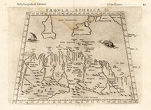
Tabula Aphricae II.
Verlag: M. Sessa Heirs 1598-99, Venice, 1598
Anbieter: Antiquariat Reinhold Berg eK Inh. R.Berg, Regensburg, Deutschland
Verkäuferbewertung 5 von 5 Sternen
Karte
Other. Woodcut, uncolored as published. Sixth edition of Ruscelli's translation of Ptolemy's Geografia edited and extended by Giuseppe Rosaccio publised by the heirs of M. Sessa in 1598 and 1599. In very good to excellent condition. 190 by 246mm (7˝ by 9ľ inches).
-
Asia
Verlag: Asia
Anbieter: Sergio Trippini, Gavirate, VA, Italien
Verkäuferbewertung 4 von 5 Sternen
Raffigurazione del continente asiatico in decorativa cornice.
-
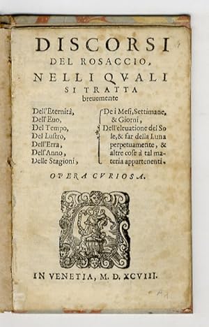
Discorsi del Rosaccio, nelle quali si tratta brevemente dell'Eternitŕ, dell'Evo, del Tempo, del Lustro, dell'Erra, dell'Anno, delle Stagioni, de i Mesi, Settimane & Giorni, dell'elevazione del Sole, & far della Luna perpetuamente, & altre cose a tal materia appartenenti. Opera curiosa.
Anbieter: Libreria Oreste Gozzini snc, Firenze, FI, Italien
Verkäuferbewertung 5 von 5 Sternen
In Venezia, (Domenico Farri), 1598, in-8, cartone marmorizzato posteriore, pp. 13, (11:su 19). Una marca tipografica al frontespizio (donna con bimbo in braccio ed altri 2 in piedi ai lati; nel cartiglio: "Charitas"; entro cornice tipografica) in xilografia, indica come stampatore Farri: originario di Rivoltella, ma attivo a Venezia (ove fu iscritto alla corporazione dei librai) in proprio dal 1555; lavorň spesso su commissione per terzi, realizzando anche diverse contraffazioni di edizioni di successo, che lo portarono a richiami dell'Inquisizione. Questo esemplare č privo delle carte A8, B1, B7, B8; la carta B2 č invece legata fuori posto; mancano dunque: tavole di Lunario per gli anni 1596-1603, carta relativa alle "Hore del giorno e della notte, da che pianeta siano dominate" e la Tavola dei pianeti (al verso: carta finale, bianca). Gioseffo Rosazio (Pordenone 1530 c. - Firenze? 1620) fu medico, cosmografo, cartografo, astronomo-astrologo, viaggiatore e venditore di libri; a Venezia, Bologna e Firenze (ove dal 1590 ottenne la protezione del granduca Cosimo II, aprendo un suo "banco" di libri), ebbe multiforme attivitŕ e fu prolifico autore. Questa rara operetta fa parte della produzione probabilmente destinata "al consumo", sia nelle pubbliche piazze che nei palazzi dei signori.
-

XVII. Descrittione del Foro di Giulio Formum Iulii, et Histria
Verlag: Artist: Rosaccio Gioseppe; issued in: Venice; ca:, 1598
Anbieter: Antique Sommer& Sapunaru KG, München, Deutschland
Verkäuferbewertung 3 von 5 Sternen

Technic: Copper print, colorit: original colored, condition: Perfect condition, size (in cm): 26 x 17 cm, Map shows Istria and partly Italy.
-

Toscana nuova tavola
Verlag: Venezia, 1598
Anbieter: Libreria Ex Libris ALAI-ILAB/LILA member, Roma, RM, Italien
Verkäuferbewertung 4 von 5 Sternen
Karte
Carta geografica originale (cm. 26,5x18,5 piů ampi margini bianchi) tratta dalla 'Geografia di Claudio Tolomeo alessandrino.' pubblicata da Girolamo Ruscelli. Due minuscoli forellini di tarlo nella parte incisa, ma esemplare in ottimo stato di conservazione. Non comune.
-
Il Medico del Dottore in filosofia, et medicina, & osservatore de motti celesti. Libri tre
Verlag: appresso Pietro Farri, in Venetia, 1621
Anbieter: Libreria Ex Libris ALAI-ILAB/LILA member, Roma, RM, Italien
Verkäuferbewertung 4 von 5 Sternen
Erstausgabe
Legatura coeva floscia con titolo ms. al ds. (tracce di tarlo ai contropiatti). Antiche note ed un timbro di vecchia libreria antiquaria sulla carta di guardia libera anteriore. Firmetta di appartenenza cassata al primo frontespizio. Timbretto araldico ex libris al margine di p. 1. Esemplare in ottimo stato di conservazione. Rara edizione originale. La prima parte tratta di astrologia medicale o iatromatematica (posizione della Luna nei segni e suoi effetti quando una persona si ammala; aspetti degli altri pianeti; aforismi di Ippocrate). La seconda e la terza parte trattano rispettivamente di rimedi medicali e alchemici (cfr. Cantamessa, Biblioastrology, n. 6857). Cfr. anche Krivatsy (9938), Wellcome (I, 5565), Bibliotheca Magica Casanatense (1073), Vinciana (2024). 8vo (cm. 21,5), 4 cc.nn., 308 pp., 7 cc.nn., da p. 311 a p. 356, 2 cc.nn. Con tre illustrazioni n.t. (strumenti di distillazione). Frontespizio di ciascun Libro entro ricca cornice allegorica. Capilettera e fregi xilografici n.t.
-

America
Verlag: Venice, 1605
Anbieter: Clive A. Burden Ltd., Chalfont St. Giles, BUCKS, Vereinigtes Königreich
Verkäuferbewertung 5 von 5 Sternen
Karte Signiert
EUR 801,24
EUR 25,53 Versand
Versand von Vereinigtes Königreich nach USAAnzahl: 1 verfügbar
In den WarenkorbNo binding. Zustand: Very Good. 200 x 265 mm., in good condition. The earlier Italian editions of the popular work entitled 'Le Relationi Universali', by Giovanni Botero (1540-1617), contained either the exceedingly rare Giovanni Lorenzo d'Anania map of 1582, or that used for the 1595 edition. For this Venice edition a new set of copperplates was cut. It is an enlarged and distinctively engraved map. The map was engraved by Giuseppe Rosaccio (c.1530-1620) who signed the Asia map in the series. Rosaccio was a geographer and physician from Friuli in the Veneto, Italy. He wrote on many subjects other than geography. Cartographically it is derived from the earlier maps but ultimately that of Abraham Ortelius. Provenance: Juan and Peggy Rada Collection. Burden (1996) 149; not in Nordenskiold; not in Phillips Atlases; not in Shirley atlas in the BL.
-
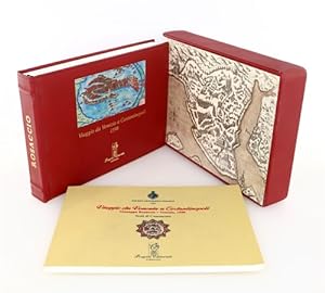
Viaggio da Venezia a Costantinopoli. (Venezia 1598). Riproduzione originale dell'Edizione veneziana del 1598, realizzata dall'Editore Giacomo Franco e dedicata all'Ambasciatore della Serenissima, Marco Veniero. Commentario al Facsimile con presentazione del Professor Franco Salvatori della Societŕ Geografica Italiana e Compendio critico con testi di Gabriella Airaldi, Simonetta Conti, Francesco Surdich, Mustafa Soykut e Orietta Selva.
Verlag: Progetto Editoriale, 2007
Anbieter: FIRENZELIBRI SRL, Reggello, FI, Italien
Verkäuferbewertung 5 von 5 Sternen
Zustand: COME NUOVO. Progetto Editoriale cm.22x31, pp.90 di commentario con facsimile di pp.164, di acquarelli in riproduzione con testi a fronte. Rilegatura artigianale in cuoio rosso con impressioni in oro a caldo e a secco. Formella centrale sul piatto di coperta.Custodia in pelle faaciata In carta. Stampato su carta speciale Tintoretta Neve da gr.250 delle Cartiere Fedrigoni. Tiratura in 300 esemplari numerati. Nostro n. 294. Alla fine del '500, Giuseppe Rosaccio, raffinato artista friulano, cartografo e viaggiatore, realizzň un'Opera unica e straordinaria per bellezza ed importanza storico scientifica. Un vero gioiello arrivato a noi attraverso secoli e custodito nella Sezione "Rari" della Biblioteca della Societŕ Geografica Italiana. Si tratta infatti dell'unico esemplare completo dei 72 acquarelli e di tutte le descrizioni a stampa di cui si compone l'Opera. Soltanto 27 anni prima, nel 1571 a Lepanto, l'Adriatico fu teatro di una storica e terribile battaglia navale fra la flotta della Lega Santa e quella ottomana. Ma la via che da Venezia, per terra e per mare, portava a Costantinopoli era anche via di commerci, di scambi culturali, di viaggi di scoperta. Dalle propaggini dell'Istria, alla costa dalmata, attraverso le impenetrabili montagne della Bosnia, dell'Erzegovina, del Montenegro, fino ed oltre i porti dell'Albania e le isole dell'Egeo, una moltitudine di popoli, di razze, di tradizioni, vivevano in continuo contatto, fra guerra e pace, dando vita alle vicende affascinanti e misteriose della storia di quel tempo. Rosaccio, attento e curioso cronista dell'epoca, ripercorre questo itinerario annotando ogni dettaglio e illustrando magnificamente cittŕ, porti, golfi, castelli, fiumi e catene montuose distribuiti all'interno del Mediterraneo orientale. Il Mediterraneo appunto, fra due culture a contatto, fra Islam ed Europa, in una attualissima riproposizione di grandi questioni tuttora aperte e tormentate.
-
Le Sei Eta del Mondo
Verlag: Venice: 1598, 1598
Anbieter: Arader Galleries - AraderNYC, New York, NY, USA
Verkäuferbewertung 5 von 5 Sternen
Signiert
12mo., (5 4/8 x 3 6/8 inches). Fine woodcut map of the world, signed by Rosaccio and dated 1590, woodcut initials and tail-piece. Disbound. Provenance: one or two early marginal annotations; with Frank Hollins "Dealer in Rare, Curious and Miscellaneous Books", London, sold to; William Gwinn Mather (1857 - 1951), American Industrialist of Cleveland Ohio, in 1928, with original addressed envelope. Rosaccio was a physician, and an author of many geographical books, editing an edition of Ptolemy's geography in 1598. In 1594 he published a little book about the world with woodcut maps, including this one of the world. It clearly shows North and South America: "America sive India Nova" with the landmass including the "Circolo Artico", "Espania Nova", Peru, Brasil and Chili. New Guinea is also shown to be separate from the southern landmass: "Tera Incognita". Burden 84 and 89.
-
Teatro del cielo e della terra. (With) Le sei eta del mondo. (and) Discorsi. (and) Della nobilta et grandezza dell'huomo.
Sprache: Italienisch
Verlag: [s.n.], Venice, 1595
Anbieter: Sokol Books Ltd. ABA ILAB, London, Vereinigtes Königreich
Verkäuferbewertung 5 von 5 Sternen
EUR 4.570,02
EUR 48,40 Versand
Versand von Vereinigtes Königreich nach USAAnzahl: 1 verfügbar
In den Warenkorb8vo. 56. 43 (v). 13 (xix [tables]). (xvi). Roman letter. T-ps of first and second works with woodcut world maps, second and third with woodcut vignettes. First work with four double-page maps of Europe, Africa, Asia and the Americas, half-page woodcut maps and diagrams. Woodcut initials, woodcut and typographical tailpieces. Third work with 16 pp. of lunar, solar and planetary tables. Intermittent very light waterstain to lower blank margin and outer corner beginning second work, B1-2 of third work slightly stained at lower outer corner. A few letters of second work trimmed at upper margin. Small paper flaws to margin of last just touching one or two letters. Very good copies in original carta rustica binding. Red crayon to last verso. A lovely sammelband of rare scientific works by the Italian cosmographer, geographer, physician, astrologer and traveller Giuseppe Rosaccio (c.1530-c.1620). Rare fourth ed. of first work, first pub. 1592; third ed. of second, first pub. 1593; extremely rare third ed. of third, first pub. 1593; and extremely rare second ed. of fourth, first published 1594. The first work, charmingly illustrated, is a geographical and astronomical texts describing the earthly and heavenly spheres, with lunar tables. The characterful maps depict the major continents with their chief cities, mountain ranges, rivers and lakes, with occasional fanciful depictions of tribal tents, trading vessels, hippocampi and giant sea fish. Australia and New Guinea are depicted as one contiguous land mass with Antarctica, with trees and shrubs, fierce-looking mountains and even what appear to be subterranean fires. The second work is a cosmographical history of the world, beginning with the creation to the age of the biblical patriarchs and Noah's Flood, 1656 years, and running to the modern day, with dates of the elections of popes, reigns of kings and queens, battles and extraordinary astrological, meteorological and medical phenomena, freakish births, etc. The third contains a brief discourse on the nature of time, preceding tables of astrological ephemerides describing the movements of the moon, sun and planets: the lunar and solar tables cover the years 1594-1612 but the planetary table - showing which planets will govern fertility or sterility in which year - runs to 1705. The final work is a brief philosophical and medical treatise on the perfect nature and proportions of man, which ends with a brief annual regimen of diet, bathing and exercise for preserving good health: no honey in February, sweets and sweet wines in March, don't wash your head in January or October, etc. Originally from Pordenone, Rosaccio was an itinerant philosopher who moved around the noble courts of Italy and travelled to Constantinople. He spent time in Venice and then from the 1590s was based permanently in Florence, 'healing the sick and selling elixirs [and presumably these tracts] from a market stall set up in a square outside the grand ducal palace' (Edina Adam, 'The Personification of Venice' in Master Drawings, 55. 3 (2017), p. 313). It was during this period that he also published several separate planispheres and maps. All early editions of these works are extremely scarce. Of the first and second work, OCLC records copies of these editions only at the Folger in the US. The third and fourth works in these editions are unrecorded in the US. Not in Adams. None of these eds in Riccardi or BM STC It. I: EDIT16 CNCE 50310. USTC 853358. Cantamessa 3884. Alden 595/69. Sabin 73198. II: EDIT16 CNCE 50312. USTC 853357. Not in Cantamessa. Alden 595/68. Sabin 73197. III: EDIT16 CNCE 69645. USTC 853355. This ed. not in Cantamessa. IV: EDIT16 CNCE 71180. USTC 853354. Not in Cantamessa.
-
![Bild des Verkäufers für [Untitled map of Greece.] zum Verkauf von Altea Antique Maps](https://pictures.abebooks.com/inventory/md/md31158464243.jpg)
[Untitled map of Greece.]
Erscheinungsdatum: 1615
Anbieter: Altea Antique Maps, London, Vereinigtes Königreich
Verbandsmitglied: ABA ILAB PBFA
Verkäuferbewertung 5 von 5 Sternen
Karte
EUR 237,40
EUR 40,34 Versand
Versand von Vereinigtes Königreich nach USAAnzahl: 1 verfügbar
In den WarenkorbVenice, c.1615, Italian text on reverse. Coloured woodcut, printed on two sheets and conjoined, printed area 125 x 160mm. An unusal map of Greece, published in Rosaccio's 'Teatro del Cielo, e della Terra'. An early example, without the notches in the printed border seen in later editons. ZACHARAKIS: 2979.
-

Liesena Isola.
Erscheinungsdatum: 1713
Anbieter: Altea Antique Maps, London, Vereinigtes Königreich
Verbandsmitglied: ABA ILAB PBFA
Verkäuferbewertung 5 von 5 Sternen
Karte
EUR 261,14
EUR 40,34 Versand
Versand von Vereinigtes Königreich nach USAAnzahl: 1 verfügbar
In den WarenkorbPadua: Lasor a Varea, 1713. Map size 100 x 175mm, set in a larger page with text, full page size is 350 x 230 The island and city of Hvar, first published in Rosaccio's 'Viaggio da Venetia a Constantinopoli' in 1598.
-
![Bild des Verkäufers für [Untitled map of Europe]. zum Verkauf von Geographicus Rare Antique Maps](https://pictures.abebooks.com/inventory/md/md32068514366.jpg)
[Untitled map of Europe].
Erscheinungsdatum: 1688
Anbieter: Geographicus Rare Antique Maps, Brooklyn, NY, USA
Verbandsmitglied: ABAA ESA ILAB
Verkäuferbewertung 4 von 5 Sternen
Karte
Good. Left margin extended with thread holes in border filled in ms. Else very good. Size 5.25 x 6.75 Inches. This attractive woodcut map of Europe was executed by Giuseppe Moretti for inclusion in the 1688 edition of Giuseppe Rosaccio's Teatro del Mondo . It is an entertaining composition, embellished with tents indicating the nomadic hordes historically menacing Poland and Lithuania from above the Black Sea. The production of a woodcut map in this period is itself unusual, especially coming from Italy. Venetian and Roman mapmakers had been working on copperplate well before that technology had passed to Antwerp and Amsterdam. A Closer Look The map illustrates the continent, as well as islands in the north Atlantic such as the Orkneys and Shetlands; its detail is drawn from Ortelius' 1570 folio Europa; it contains detail not present on the miniature map appearing in Ortelius' Epitome atlases. For example, the phantom island of Demar is shown off the coast of Ireland (albeit in the location that Ortelius had placed the island of Brasil ). Iceland is shown, as is the southern coast of Greenland. The latter contains the imaginary monastery of St. Thomas, which Ortelius had adopted from the fraudulent geography of Nicolo Zeno. Publication History and Census This map was produced by Giuseppe Moretti for the 1688 Antonio Pisarri edition of Rosaccio's Teatro del Mondo . Both this book, and separate maps from it, are scarce. We see no examples of the map in OCLC, and seven examples of the 1688 book. A 1724 edition exists, apparently using the same blocks; only five of these are listed in institutional collections and no separate maps.
-
![Bild des Verkäufers für [Untitled map of Eastern Europe]. zum Verkauf von Geographicus Rare Antique Maps](https://pictures.abebooks.com/inventory/md/md32068513465.jpg)
[Untitled map of Eastern Europe].
Erscheinungsdatum: 1688
Anbieter: Geographicus Rare Antique Maps, Brooklyn, NY, USA
Verbandsmitglied: ABAA ESA ILAB
Verkäuferbewertung 4 von 5 Sternen
Karte
Good. Right margin extended with thread holes in border filled. Else very good. Size 5 x 6.75 Inches. This attractive woodcut map of Lithuania, Ukraine, Bulgaria, Russia, and the Black Sea was executed by Giuseppe Moretti for inclusion in the 1688 edition of Giuseppe Rosaccio's Teatro del Mondo . It is an entertaining composition, embellished with tents indicating Muscovy and Tatary, menacing Lithuania from above the Black Sea. The production of a woodcut map in this period is itself unusual, especially coming from Italy. Venetian and Roman mapmakers had been working on copperplate well before that technology had passed to Antwerp and Amsterdam. A Closer Look The map focuses on Eastern Europe - from Serbia in the west to include the Sea of Azov in the east, and reaching as far north as Lithuania, Livonia and Muscovy. Mountains, forests, and cities are indicated pictorially. Muscovy and Tatary are indicated with the tents of the steppe nomads. Though Moretti's woodcut was executed in 1688, it is based on the map appearing in editions of Rosaccio as early as 1594. Unlike most of the Rosaccio maps, this is not a reduction of any specific map, but the placenames appear to be derived from various maps produced by Gastaldi in the mid 16th century. This final 1688 edition of the map is notable for being cut to a single block rather than two separate blocks. Publication History and Census This map was produced by Giuseppe Moretti for the 1688 Antonio Pisarri edition of Rosaccio's Teatro del Mondo . Both this book, and separate maps from it, are scarce. We see no examples of the map in OCLC, and seven examples of the 1688 book. A 1724 edition exists, apparently using the same blocks; only five of these are listed in institutional collections and no separate maps.
-
![Bild des Verkäufers für [Untitled map of Africa]. zum Verkauf von Geographicus Rare Antique Maps](https://pictures.abebooks.com/inventory/md/md32068514390.jpg)
[Untitled map of Africa].
Erscheinungsdatum: 1688
Anbieter: Geographicus Rare Antique Maps, Brooklyn, NY, USA
Verbandsmitglied: ABAA ESA ILAB
Verkäuferbewertung 3 von 5 Sternen
Karte
Good. Left margin extended with threadholes in border filled in ms. Else very good. Size 5.25 x 6.75 Inches. This attractive woodcut map of Africa was executed by Giuseppe Moretti for inclusion in the 1688 edition of Giuseppe Rosaccio's Teatro del Mondo . It is an entertaining composition, embellished with a sea monster in the Atlantic and a sailing ship entering the Indian Ocean. The appearance of a woodcut map in this period is itself unusual, especially coming from Italy. Venetian and Roman mapmakers had been working on copperplate well before that technology had passed to Antwerp and Amsterdam. A Closer Look The map illustrates the continent, as well as the Arabian Peninsula, the Persian coast, and part of Brazil. The European Mediterranean coast is roughed in. The map includes several south Atlantic islands, such as Tristan da Cunha and Ascension Island. Overall, the shape of Africa is influenced by Ortelius' 1570 map; which was earlier adopted for Rosaccio's 1594 map, which the present work was produced to replace. The present map is larger than the 1594 and was cut on a single block rather than the two used for the earlier work. Moretti only shows one of the Ptolemaic lakes of the Nile, although this appears to derive more from a misinterpretation of the 1594 map than from any geographical insights. Publication History and Census This map was produced by Giuseppe Moretti for the 1688 Antonio Pisarri edition of Rosaccio's Teatro del Mondo . Both this book, and separate maps from it, are scarce. We see no examples of the map in OCLC, and seven examples of the 1688 book. A 1724 edition exists, apparently using the same blocks; only five of these are listed in institutional collections and no separate maps. References: Not in OCLC. Betz, Richard The Mapping of Africa #144.
-
![Bild des Verkäufers für [Untitled map of Asia]. zum Verkauf von Geographicus Rare Antique Maps](https://pictures.abebooks.com/inventory/md/md32068516269.jpg)
[Untitled map of Asia].
Erscheinungsdatum: 1688
Anbieter: Geographicus Rare Antique Maps, Brooklyn, NY, USA
Verbandsmitglied: ABAA ESA ILAB
Verkäuferbewertung 3 von 5 Sternen
Karte
Very good. Left margin extended with no loss to printed image. Size 5 x 7 Inches. This attractive woodcut map of Asia was executed by Giuseppe Moretti for inclusion in the 1688 edition of Giuseppe Rosaccio's long-lived Teatro del Mondo . It is an entertaining composition, embellished with a sea monster in the Northern Ocean, and a sailing ship crossing the Indian Ocean. The appearance of a woodcut map in this period is itself unusual, especially coming from Italy. Venetian and Roman mapmakers had been working on copperplate well before that technology had passed to Antwerp and Amsterdam. A Closer Look The map illustrates the whole continent, as well as the Arabian Peninsula, and part of eastern Africa, including the Nile. The East Indies appear in an early, crude form; Japan's location is largely correct if not its form. Overall, the map is based on Ortelius' 1570 work; this had been adopted in Rosaccio's 1594 map, which the present work was produced to replace. The present map is larger than the 1594 and was cut on a single block rather than the two used for the earlier work. Publication History and Census This map was produced by Giuseppe Moretti for the 1688 Antonio Pisarri edition of Rosaccio's Teatro del Mondo . Both this book, and separate maps from it, are scarce. We see no examples of the map in OCLC, and seven examples of the 1688 book. A 1724 edition exists, apparently using the same blocks; only five of these are listed in institutional collections and no separate maps. References: Not in OCLC.
-

Orbis Terrae Compendiosa Descriptio.
Erscheinungsdatum: 1598
Anbieter: Geographicus Rare Antique Maps, Brooklyn, NY, USA
Verbandsmitglied: ABAA ESA ILAB
Verkäuferbewertung 3 von 5 Sternen
Karte
Very good condition. Some wormholes not impacting printed image. Size 7.25 x 9.75 Inches. This is Giuseppe Rosaccio's 1598 double-hemisphere map of the world. Although it was included in Rosaccio's 1598 edition of Ptolemy's Geographia , it is not a Ptolemaic map. Unlike most of the maps in Rosaccio's Ptolemy, which are amended versions of those that appeared in the 1561 Ruscelli Ptolemy, this one is superficially a reduction of the 1587 Mercator world map, but with parallel latitude lines, presenting a more pronounced, elongated South America and Africa - a unique and visually distinctive projection. Terra Australis or the Speculative Southern Continent Following Mercator and Ortelius, there is a massive Terra Australis dominating the Southern Hemisphere, extending from Tierra del Fuego nearly to New Guinea. This imaginary continent capping the South Pole was long supposed to exist by European geographers despite the lack of any evidence to support the notion. It was thought, based upon the writings of Aristotle, that the globe was a place of balances and thus geographers presumed the bulk of Eurasia must be counterbalanced by a similar landmass in the Southern Hemisphere. Many explorers in the 16th and 17th centuries sought the Great Southern Continent, including Quiros, Drake, and Cook, but Antarctica itself was not truly discovered until Edward Bransfield and William Smith sighted the Antarctic Peninsula in 1820. Northwest and Northeast Passages Far to the north an open Arctic Sea passage winds its way around the globe. These are the much sought-after Northwest (to the north of America) and Northeast Passages (over Asia). It was hoped that high-latitude maritime routes or 'passages' would provide quick access to the rich markets of Asia, which offered both an outlet for European silver and furs from the American colonies, as well as produced spices, silks, and other trade goods coveted in Europe. When Mercator included this on his map, no one had successfully navigated such a passage, but many scholars argued that it must exist. Countless explorers lost their lives in search of the apocryphal routes. Today, with the advent of global warming reducing the size of the Polar Ice Cap, a navigable passage has indeed formed. Publication History and Census This map appeared in both the 1598 and 1599 editions of Rosaccio's Ptolemy, both entitled Geografia di Claudio Tolomeo Alessandrino . Over a century later the plate was reutilized in Lasor a Vareas' 1713 Universus Terrarum Orbis Scriptorum. This late printing included the text 'T.2.pag.284' at the top right of the map, not present here. The separate map is cataloged only once in institutional collections, and the in the 1713 state. According to OCLC Ruscelli's Ptolemy is scarce, with the 1598 appearing in five or six and 1599 eight or nine institutional collections. References: Rumsey 11299.034 (1599 ed.). OCLC 1062350694. Shirley 217.
-
Orbis Descriptio.
Erscheinungsdatum: 1598
Anbieter: Geographicus Rare Antique Maps, Brooklyn, NY, USA
Verbandsmitglied: ABAA ESA ILAB
Verkäuferbewertung 3 von 5 Sternen
Karte Erstausgabe
Very good. Mended wormholes at bottom centerfold and in mountain area of South America; else a bold example with generous margins. Size 6.25 x 10 Inches. This is a 1598 second-state issue of Girolamo Ruscelli's 1561 map of the world. In its first 1561 state, it was the earliest acquirable double-hemisphere world map, but even this later issue remains one of the earliest acquirable maps to use this format. A Closer Look Like most maps in Ruscelli's Ptolemy, the geographic details were based on Giacomo Gastaldi's (1500 - 1566) 1548 Ptolemy. Here, the double-hemispherical projection transforms this map into a fully new composition. Amongst printed maps, it is predated only by the unacquirable 1555 Georgio Sideri Calapoda (fl. 1537 - 1565) map. The 1598 edition of Ruscelli's Ptolemy was edited by Giuseppe Rosaccio, who updated the maps to make them more competitive. In this case, there are significant geographical changes, most notably the addition of a massive southern continent - Terre Australis . The Map The map is oriented to the north, with the three parts of the Old World in the right hemisphere and the fourth part of the world - the Americas - dominating the left. Some geographical elements are derived from Gastaldi's 1546 and 1548 world maps, but overall, this map diverges from any prior source. As with Gastaldi's maps through 1561, Ruscelli's map shows a clear connection between the continents of Asia and North America. Ruscelli adds a distinctive river system extending from the Gulf of California into the continent and includes abundant imaginary mountain ranges in North America. New Shores Ruscelli's 1561 issue of the map implied the connection of North America and Asia, using broken lines to indicate unexplored or speculative territory - this was also the case with the southwest coast of South America. These coasts still bear the notations Littus incognitum and Littus ignotum , but the American Pacific Northwest is no longer ghosted, and there is an upturn in the coastline to suggest that it did not continue around to connect with Asia. The southern coasts of Tierra del Fuego and Java are no longer incomplete: Java is shown as a definite island, while Tierra del Fuego is connected to the southern continent, Terre Australis, after Mercator and Ortelius. The northern promontory of this territory, in the vicinity of Java (roughly in the location of Northern Australia), bears the place name Lucach , also influenced by the same mapmakers. An Island Northeast Ruscelli may have derived his remarkable insular northeast America from the conflation of the Hudson River and the Saint Lawrence appearing on the Gastaldi-Ramusio map. Still, these features do not appear on any of Gastaldi's printed world maps. The bay separating the American Northeast from Terra Florida may have been influenced by the Sea of Verrazano, which appears prominently on Gastaldi's Carta Marina but not his other 1548 world map. This feature remains unchanged on this 1598 edition. South America The overall shape of South America, including the mouth of the Rio de la Plata, is similar to the c. 1561 Gastaldi but differs from his earlier works and is very distinctive in its broad and angular shape. The North Part of the World Ruscelli's depiction of the Arctic is distinctive: North America extends over the Pole and bears the place name Hyperborei - a classical geographical term originally applied to northern Eurasia, and later to northern Asia. Its presence here emphasizes Ruscelli's connection of Asia and North America. A Mare Glaciale covers the rest of the north. This feature appears unique to the Ruscelli, as neither Gastaldi's maps nor any other contemporary works show the Arctic in this way. Africa The delineation of Africa, including the scattering of islands north of Madagascar, is roughly consistent with Gastaldi's geography. It preserves the Ptolemaic sourcing of the Nile and illustrates a large Senegal River with many tributaries. Madagascar itself i.
-

Venetia.
Erscheinungsdatum: 1598
Anbieter: Altea Antique Maps, London, Vereinigtes Königreich
Verbandsmitglied: ABA ILAB PBFA
Verkäuferbewertung 5 von 5 Sternen
Karte
EUR 890,26
EUR 40,34 Versand
Versand von Vereinigtes Königreich nach USAAnzahl: 1 verfügbar
In den WarenkorbVenice: Giacomo Franco, 1598. 100 x100 mm. A fine example of this copper-engraved map of Venice in the form of a bird's-eye view, published in Rosaccio's 'Viaggio da Venetia a Constantinopoli'. MORETTO: Venetia, 40.
-

Universale Descrittione di Tutto il Mondo del Ecc.te Gioseppe Rosaccio.
Erscheinungsdatum: 1610
Anbieter: Altea Antique Maps, London, Vereinigtes Königreich
Verbandsmitglied: ABA ILAB PBFA
Verkäuferbewertung 5 von 5 Sternen
Karte
EUR 5.341,58
EUR 40,34 Versand
Versand von Vereinigtes Königreich nach USAAnzahl: 1 verfügbar
In den WarenkorbFlorence, c.1610. 265 x 310mm. Trimmed on left with flap for binding, folds flattened with small repairs. A double-hemisphere world map adapted from Guiseppe Rosaccio's map of 1597 by his son Alovisio (probably Latinised from Luigi), notable for the complexity of its engraved borders. Around the Western Hemisphere are celestial constellations, interspersed with windheads (including a skull for the 'plague-bearing' southern wind); around the Eastern Hemisphere are climactic zones. In the cusps are a portrait of Duke Cosimo II de' Medici, Grand Duke of Tuscany, and his armorial, with each of the six palle (balls) containing a small map of a continent or pole and a letter of Cosimo's name. In the four corners of the main map are roundels with representations of the Four Elements. Underneath the main map is a world map after Ptolemy, disparagingly titled in Italian ''This is how much Ptolemy knew about the world'', and eight spherical diagrams, including a key of geographical terms and how shadows change at different latitudes. SHIRLEY: 268, second state, with beard added to Cosimo's portrait; 'curiously elaborate world map'.
-

Questa Tavola e l'Antica Siria ch'era destinta in dodici Tribu hora si chiama la Soria et Terra Santa poseduta dal Turco.
Erscheinungsdatum: 1598
Anbieter: Altea Antique Maps, London, Vereinigtes Königreich
Verbandsmitglied: ABA ILAB PBFA
Verkäuferbewertung 5 von 5 Sternen
Karte
EUR 1.068,32
EUR 40,34 Versand
Versand von Vereinigtes Königreich nach USAAnzahl: 1 verfügbar
In den WarenkorbVenice: Giacomo Franco, 1598. 140 x 190mm. Narrow margins, as issued. The Eastern Mediterranean with Cyprus and the Holy Land, published in Rosaccio's 'Viaggio da Venetia a Constantinopoli'. ZACHARAKIS: 2975/1958; BANK OF CYPRUS: 41.
-

Famagosta.
Erscheinungsdatum: 1598
Anbieter: Altea Antique Maps, London, Vereinigtes Königreich
Verbandsmitglied: ABA ILAB PBFA
Verkäuferbewertung 5 von 5 Sternen
Karte
EUR 1.187,02
EUR 40,34 Versand
Versand von Vereinigtes Königreich nach USAAnzahl: 1 verfügbar
In den WarenkorbNo Binding. Zustand: Fine. Venice: Giacomo Franco, 1598. 100 x 180mm. A small-format plan of Famagousta, showing the city under siege by the Turks in 1571. Published in Rosaccio's 'Viaggio da Venetia a Constantinopoli'.