Gesamtpreis (1 Artikel Artikel):
Versandziel:

rome florence (11 Ergebnisse)
Direkt zu den wichtigsten Suchergebnissen
Suchfilter
Produktart
- Alle Product Types
- Bücher (10)
- Magazine & Zeitschriften (Keine weiteren Ergebnisse entsprechen dieser Verfeinerung)
- Comics (Keine weiteren Ergebnisse entsprechen dieser Verfeinerung)
- Noten (Keine weiteren Ergebnisse entsprechen dieser Verfeinerung)
- Kunst, Grafik & Poster (Keine weiteren Ergebnisse entsprechen dieser Verfeinerung)
- Fotografien (Keine weiteren Ergebnisse entsprechen dieser Verfeinerung)
- Karten (1)
- Manuskripte & Papierantiquitäten (Keine weiteren Ergebnisse entsprechen dieser Verfeinerung)
Zustand Mehr dazu
- Neu (Keine weiteren Ergebnisse entsprechen dieser Verfeinerung)
- Wie Neu, Sehr Gut oder Gut Bis Sehr Gut (2)
- Gut oder Befriedigend (3)
- Ausreichend oder Schlecht (1)
- Wie beschrieben (5)
Einband
Weitere Eigenschaften
Sprache (3)
Gratisversand
Land des Verkäufers
Verkäuferbewertung
-

The Mill and Us
Verlag: The Flume Press
Anbieter: ThriftBooks-Dallas, Dallas, TX, USA
Verkäuferbewertung 5 von 5 Sternen

Hardcover. Zustand: Fair. No Jacket. Readable copy. Pages may have considerable notes/highlighting. ~ ThriftBooks: Read More, Spend Less.
-

The Tattooed Men : An American Woman Reports on the Japanese Criminal Underworld
Sprache: Englisch
Verlag: Random House Publishing Group, 1975
ISBN 10: 0440059607 ISBN 13: 9780440059608
Anbieter: Better World Books, Mishawaka, IN, USA
Verkäuferbewertung 5 von 5 Sternen
Erstausgabe
Zustand: Very Good. 1st. Former library copy. Pages intact with possible writing/highlighting. Binding strong with minor wear. Dust jackets/supplements may not be included. Includes library markings. Stock photo provided. Product includes identifying sticker. Better World Books: Buy Books. Do Good.
-
The Tattooed Men. An American Woman Reports on the Japanese Criminal Underworld.
Anbieter: Antikvariat Faust, Göteborg, Schweden
Verkäuferbewertung 4 von 5 Sternen

Delacorte Press, New York 1975. (10), 268 pp. Hardcover with d/w. Illustrated. Good condition.
-

Aspects de l'art en France (1950-1970) : La collection Yvonne et Maurice Allemand au Musée départemental de l'Oise
Anbieter: Librairie de l'Avenue - Henri Veyrier, Saint-Ouen, FR, Frankreich
Verkäuferbewertung 5 von 5 Sternen
Couverture souple. Zustand: Trčs bon état. In-4 broché 27,9 cm sur 25,1. 191 pages. Trčs bon état d'occasion. in-4°.
-

The Tattooed Men : an American Woman Reports on the Japanese Criminal Underworld
Sprache: Englisch
Verlag: New York, Delacorte Press, New York, 1975
ISBN 10: 0440059607 ISBN 13: 9780440059608
Anbieter: Librairie de l'Avenue - Henri Veyrier, Saint-Ouen, FR, Frankreich
Verkäuferbewertung 5 von 5 Sternen
Couverture rigide. Zustand: Bon état. Zustand des Schutzumschlags: Good. In-8 21 x 14 cm. Reliure éditeur toile moutarde, sous jaquette noire illustrée en couleurs, 268 pp., illustrations hors texte, glossaire, bibliographie. Exemplaire en bon état.
-
Edition complčte.
Verlag: Paris, Saintmichel et Egron., 1814
Anbieter: Manfred Nosbuesch, Kuchenheim, Deutschland
Verkäuferbewertung 4 von 5 Sternen
(4), 176pp. With engr. portrait. Orig. publisher's wrappers. Uncut. - Very good copy.
-

Japanese Sketches
Verlag: Flume Press, 1980
Anbieter: True Oak Books, Highland, NY, USA
Verbandsmitglied: IOBA
Verkäuferbewertung 5 von 5 Sternen
Signiert
Hardcover. Zustand: Good+. Signed by Author; Slipcover included and in good condition. - Brief dedication on first page. Signed by author! Light foxing to edge of pages. - Good overall condition. General wear. No major blemishes. No writing. ; - We're committed to your satisfaction. We offer free returns and respond promptly to all inquiries. Your item will be carefully wrapped in bubble wrap and securely boxed. All orders ship on the same or next business day. Buy with confidence.
-
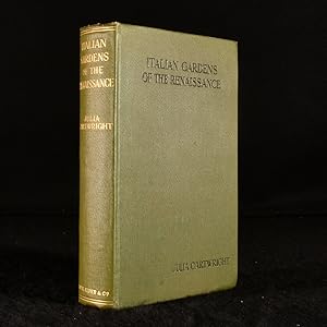
Italian Gardens of the Renaissance and Other Studies
Verlag: Smith, Elder Co., London, 1914
Anbieter: Rooke Books PBFA, Bath, Vereinigtes Königreich
Verbandsmitglied: PBFA
Verkäuferbewertung 5 von 5 Sternen
Erstausgabe
EUR 101,61
EUR 23,20 Versand
Versand von Vereinigtes Königreich nach USAAnzahl: 1 verfügbar
In den WarenkorbCloth. Zustand: Very Good Indeed. Florence Alinari; Rome Anderson; Various (illustrator). First edition. A first edition of Julia Cartwright's study of Italian Renaissance gardens with illustrations. First edition in original publisher's cloth binding of 'Italian Gardens of the Renaissance and Other Studies' by Julia Cartwright Ady with illustrations and personal letter from the author inserted This study was written in memory of Cartwright's friend, Lady Enid Layard, and her love for Venice which she had made her home. The contents of the study includes not only the gardens of Venice, but also of Papal Rome, Florentine Humanists gardens, and more. Julia Cartwright was a late nineteenth and early twentieth century British historian and art critic. Her work mainly encompassed the Renaissance period in Italy. Her dedication was aided by her cousin, art collector and politician William Cornwallis Cartwright who shared his collections. She also read historical Italian texts from a young age, which instilled her fascination with the Italian Renaissance. Includes 16 monochrome plates. Collated, complete. No dust wrapper. Letter transcription: Dear ? Will you accept this little book of mine as a small token of affection & of all the happiness I hope you will have in [?] new life. I know how sadly you will be missed here. Forgive me by writing such a stupid letter & with my very best wishes & much love, Eva V. ? Julia M. Ady In original publishers binding. Externally, generally smart. No dust wrapper present. Very minor bumping to the head and tail of the spine and to the extremities. Internally, firmly bound. Pages are bright and clean with some occasional spotting, particularly to the endpapers. Tissue guard to the front piece is present and intact. Very Good Indeed. book.
-
A Visitor's Map of Florence.
Verlag: S. Davite, printer, Florence (um 1928)., 1928
Anbieter: Antiquariat A. Suelzen - Angela Sülzen, Berlin, Deutschland
Verkäuferbewertung 5 von 5 Sternen
Monumental Map / Große farblithogr. Bildkarte von Florenz, 45 x 63,5 cm, verso Informationen in englischer Sprache. Gefaltet auf 22,8 x 10,5 cm.
-
DIRECTORIUM SUPERIORUM REGULARIUM, & ECCLESIASTICORUM, CONTINENS CENTUM SEPTEM SERMONES DOCTRINALES AC SPIRITUALES, VARIA THEMATA PRO VISITATIONIBUS, INVESTITIONIBUS, PROFESSIONIBUS, c. Authore R. P. F. Evangelista de Momigno Ord. FF. Minorum S. Francisci de observantia quondam Vicario Generali, Provinciae Tusciae SS. Theol. Lectore Jubilato, & Praedicatore Famosissimo, post tres editiones Italicas, nunc latinitate donatum Opera, studio R. P. Fr. Brunonis Neusser eiusdem Ord. FF. Minorum Recollectorum Provinciae Coloniae SS. Theologiae Lectoris. Cum Indicibus necessariis ac Tabula Sermonum, Editio secunda correctior, Aucta cum quatuor decim novis Concionibus ex italico Translatis. - Coloniae Aggrippinae Apud Joannem Busaeum, Bibliopolam sub Monocerote. Anno M. DC. LXV. Cum Privilegio Casareo[!]. [Nonaginta Tres Sermones Spirituales, . . ., & Praedicatore Clarißimo, . . .; Regvlarium ecclesiasticorvm centvm Avthore Brvnonis Nevsser]
Verlag: Cologne Aggrippina, Johann Busaeus, 1665., 1665
Anbieter: C O - L I B R I , Bremen - Berlin ; Deutschland / Germany ., Berlin, Deutschland
Verkäuferbewertung 5 von 5 Sternen
Titlepage in red and black with larger allegoric woodcut, (18) 428 (until 'Sermo LXXXI'), 156 (Sermo LXXXI CVII), (31; 'Index Locorum sacrae Scripturae . . .', 'Index Rerum et Verborum notabilium, .:', 'Elenchus ad Conciones formandas pro Dominices et Festis totius Anni.'). - Full vellum binding of the period with manuscript title at top-of-spine, long woolen string clasps and blank endpapers; 4to.(ca. 20 x 18 x 5 cm.). *** [FRÜHSOMMER-VERKAUF / EARLY SUMMER-SALE: um über 20% REDUZIERTER PREIS bis Montag, den 29.06.2026 / PRICE-REDUCTION of over 20% until Monday, June 29; vorheriger Preis / previously EUR 280,-] --- FIRST REVISED AND AUGMENTED EDITION, VELLUM-BOUND ORIGINAL; COMPLETE. - Binding somewhat spotty, endpapers slightly sunned; A VERY GOOD COPY.
-

Status Ecclesiastici Magnique Ducatus Florentini Nova Exhibitio.
Erscheinungsdatum: 1710
Anbieter: Geographicus Rare Antique Maps, Brooklyn, NY, USA
Verbandsmitglied: ABAA ESA ILAB
Verkäuferbewertung 4 von 5 Sternen
Karte Erstausgabe
1st Edition. Very good. Strong impressions with rich original color. Minor soiling towards bottom, mostly confined to margin. Repaired tear at bottom near centerfold. Size 20.5 x 23.5 Inches. A striking first edition example of Johann Baptist Homann's c. 1710 map of the Papal States of central Italy, including Rome, Florence, and the other grand cities of Tuscany and nearby regions. It was produced during the War of the Spanish Succession (1701 - 1714), which reshaped the political landscape of much of Italy. A Closer Look Coverage ranges from Mantova and the Po River at the top to Gaeta at the bottom, taking in Tuscany, Rome, and nearby regions. Cities and towns are recorded in detail, with fortified cities illustrated with walls. Mountains, waterways, forests, and administrative boundaries are likewise meticulously documented. Rome is situated towards the bottom right, and Florence is near the center on the Arno River. Additional cities such as Pisa, Ravenna, Bologna, and Ferrara are easily identifiable. An elaborate title cartouche includes multiple symbols of the Papacy, including the Papal Cross and Papal Mitre. The Lago di Celano, also known as the Lago Fucino, east of Rome, was once the third largest lake in Italy but no longer exists, having been drained in 1878. Since Roman times, when the settlement of Marruvium was founded on its eastern shore, the lake had posed risks of floods and disease as the waters had no natural outflow. Thus, after years of planning and construction, a canal was built, and the lake drained, leaving behind an extremely fertile plain (Piana del Fůcino) ideal for farming (since the 1960s, the dried lakebed also hosts a large satellite telecommunications center). Similar drainage projects were employed in the 19th century on other ancient lakes present here, such as the Lago di Sesto near Bientina, east of Pisa. Conversely, the Valli di Comacchio east of Ferrara and Bologna at the top was a relatively recent development, forming in the tenth century due to silting and erosion and filling with seawater beginning in the 16th century. Though the wetlands have been gradually reduced from their considerable extent seen here, they are today a largely protected wildlife preserve and remain one of the largest wetlands in Italy. The War of the Spanish Succession During the War of Spanish Succession (1701 - 1714), different regions of Italy served as a battleground contested by major European powers. The war, prompted by the death of Spanish King Charles II without an heir, led to a wide-ranging struggle between the Habsburgs and Bourbons and drew in neighboring powers. Since Spain controlled the duchies of Milan and Mantua, these became points of contention in the struggle. France quickly moved to occupy the formerly Spanish possessions in northern Italy. Austrian troops drove the French out of Italy after breaking the French Siege of Turin in 1706, leaving the Habsburgs and Savoys as the major powers in northern Italy and throughout Italy writ large until the rise of Napoleon. As for the Papal States, although they had origins in the era of the Roman Empire, the pope's 'rule' over these lands was mostly nominal. However, a series of popes in the late 15th - 17th centuries fought to expand their temporal powers, becoming entangled in European geopolitics and warfare in the process. In addition to more closely controlling territories under their domain, the popes of this era also conquered or reclaimed territories that had once theoretically been part of the Papal States, including Ferrara and Urbino. Publication History and Census This map was prepared by Johann Baptist Homann between 1707 and 1710 for inclusion in the 1710 edition of his Neuer Atlas . The present example can be compared to the following state of the map from c. 1716 (also offered by us: StatusEcclesiastici-homann-1716), which though superficially similar, was, in fact, an entirely new plate, adding Homann's royal Privilege, modifying the title cart.