Rapkin john (289 Ergebnisse)
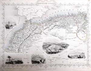
steal engraving / Grenzcolorierter Stahlstich Northern Africa. Mit weiteren 5 Bildstahlstichen 1)Mogador. 2) Marocco. 3) Constantine. 4) Algiers. 5)Tunis.
Martin, R.M. (Hrsg.) - Winkles, H. (ill) /Greatbach,G. (engraved) / Rapkin, John (The Map Drawn & Engraved by):
Sprache: Englisch
Verlag: The London Printing and Publishing Company. o.J. [ca 1850], 1850
- Softcover
- Erstausgabe
Anbieter: Antiquariat Carl Wegner, Berlin, B, DeutschlandAntiquariat Carl Wegner
Verkäufer/-in kontaktierenVerkäufer/-in mit 5 SternenVerbandsmitglied: GIAQ
Zustand: Gebraucht
EUR 17,70
EUR 9,00 VersandVersand von Deutschland nach USAAnzahl: 1 verfügbar
Softcover. Blattgröße 27x36 cm, Stichgröße 21 x 30 cm, mittig längs gefaltet. Die Tafel mit floraler Rahmung, eingezeichneten Längen- und Breitengraden und Maßstabsangabe. Das Blatt an den Rändern und in der Querfalte leicht lichtrandig und fingerfleckig, an der linken unteren Ecke eine Faltstelle, sonst schönes Exemplar. --- In… english language. Good condition. Die Tafel beschriftet mit der Ziffer 61. Wahrscheinlich die entsprechende Tafel aus dem Werk von John Tallis: Illustrated atlas and modern history of the world. -- Zu dekorativen Zwecken, zum Rahmen geeignet. Weitere Karten aus dem gleichen Werk vorhanden. "John Rapkin was a mapmaker who was concerned with the aesthetic value of his work as well as cartographic content. His fine maps are distinguished by the trademark decorative borders, vignettes and title displays. Rapkin worked in close association with the equally respected publisher John Tallis. The publishing rights of many of the maps passed to The London Printing and Publishing Company circa 1850. " -- Bitte Portokosten außerhalb EU erfragen! / Please ask for postage costs outside EU! / S ' il vous plait demander des frais de port en dehors de l ' UE! // Bitte beachten Sie auch unsere Fotos! / Please also note our photos! / Veuillez noter nos photos -- Sommerzeit daheim oder auf Reisen: bei uns finden Sie sicher ein passendes Buch zur Begleitung. -- Wir kaufen Ihre werthaltigen Bücher! GM25-502030.

Verlag: London Printing and Publishing Company, London, 1860
- Softcover
Anbieter: Victoria Bookshop, BERE ALSTON, DEVON, Vereinigtes KönigreichVictoria Bookshop
Verkäufer/-in kontaktierenVerkäufer/-in mit 3 SternenZustand: Gebraucht - Befriedigend
EUR 21,18
EUR 11,55 VersandVersand von Vereinigtes Königreich nach USAAnzahl: 1 verfügbar
Paperback. Zustand: G-. First Thus. Minor splits to top and tail edges, this map has been folded Minor foxing. Decorative Black & White 19th century map for the Image Size: 350 x 245mm, 13.75 x 9.75" approx. Paper Size: 390 x 285mm, 15.25 x 11.25" approx. John Rapkin (fl. 1835-65) A nineteenth century map maker and engraver, bes…t known for his work on the Illustrated Atlas of the World 1849-53 for John Tallis and Co. noted for their beautifully decorative borders and later re-issued by the London Printing and Publishing Co. London and New York. Book.
Verlag: London Printing and Publishing Company, London, 1860
- Softcover
Anbieter: Victoria Bookshop, BERE ALSTON, DEVON, Vereinigtes KönigreichVictoria Bookshop
Verkäufer/-in kontaktierenVerkäufer/-in mit 3 SternenZustand: Gebraucht - Befriedigend
EUR 30,69
EUR 11,55 VersandVersand von Vereinigtes Königreich nach USAAnzahl: 1 verfügbar
Paperback. Zustand: G-. First Thus. Minor splits to tail edge, this map has been folded. Very minor foxing. Decorative Black & White 19th century map for the Image Size: 350 x 245mm, 13.75 x 9.75" approx. Paper Size: 390 x 285mm, 15.25 x 11.25" approx. John Rapkin (fl. 1835-65) A nineteenth century map maker and engraver, best k…nown for his work on the Illustrated Atlas of the World 1849-53 for John Tallis and Co. noted for their beautifully decorative borders and later re-issued by the London Printing and Publishing Co. London and New York. Book.
Verlag: London Printing and Publishing Company, London, 1860
- Softcover
Anbieter: Victoria Bookshop, BERE ALSTON, DEVON, Vereinigtes KönigreichVictoria Bookshop
Verkäufer/-in kontaktierenVerkäufer/-in mit 3 SternenZustand: Gebraucht - Befriedigend
EUR 30,69
EUR 11,55 VersandVersand von Vereinigtes Königreich nach USAAnzahl: 1 verfügbar
Paperback. Zustand: G-. First Thus. Minor creasing and a number of splits/1 long closed tear to tail edge. nick to RH side edge with small loss. this map has been folded. Very minor foxing. Decorative Black & White 19th century map for the Image Size: 350 x 245mm, 13.75 x 9.75" approx. Paper Size: 390 x 285mm, 15.25 x 11.25" app…rox. John Rapkin (fl. 1835-65) A nineteenth century map maker and engraver, best known for his work on the Illustrated Atlas of the World 1849-53 for John Tallis and Co. noted for their beautifully decorative borders and later re-issued by the London Printing and Publishing Co. London and New York. Book.
Verlag: John Tallis & Co., London, 1854
Anbieter: Antipodean Books, Maps & Prints, ABAA, Garrison, NY, USAAntipodean Books, Maps & Prints, ABAA
Verkäufer/-in kontaktierenVerkäufer/-in mit 4 SternenZustand: Gebraucht
EUR 25,24
EUR 8,75 VersandVersand innerhalb von USAAnzahl: 1 verfügbar
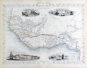
Maps. Steel engraved map from the famous Victorian publisher John Tallis, well-known for the attractive vignette views surrounding the maps, which illustrate the peoples & customs of the region. 9 3/4 x 13 1/2" plus margins. Attractive decorative border around edge, very good condition.
Verlag: John Tallis & Co., London, 1854
Anbieter: Antipodean Books, Maps & Prints, ABAA, Garrison, NY, USAAntipodean Books, Maps & Prints, ABAA
Verkäufer/-in kontaktierenVerkäufer/-in mit 4 SternenZustand: Gebraucht
EUR 25,24
EUR 8,75 VersandVersand innerhalb von USAAnzahl: 1 verfügbar
Maps. Steel engraved map from the famous Victorian publisher John Tallis, well-known for the attractive vignette views surrounding the maps, which illustrate the peoples & customs of the region. 12 1/2 x 10" plus margins. Attractive decorative border around edge, period outline color, very good condition.
Sprache: Englisch
Verlag: London Printing and Publishing Company, London, 1853
Anbieter: Kaaterskill Books, ABAA/ILAB, East Jewett, NY, USAKaaterskill Books, ABAA/ILAB
Verkäufer/-in kontaktierenVerkäufer/-in mit 5 SternenZustand: Gebraucht
EUR 45,08
EUR 6,13 VersandVersand innerhalb von USAAnzahl: 1 verfügbar
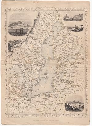
1 sheet, folded. 27 x 37 .5 cm. Engraved map, outlined in color, with five engraved vignettes. 27 x 37.5 cm. Contains decorated border. Illustrations drawn & engraved by H. Winkles, and depict Kronstadt, Revel, St. Petersburg, Abo, and Helsingfors. Taken from Tallis' "Illustrated Atlas and Modern History of the World" or "The Il…lustrated War with Russia", after he formed a partnership with Ephraim Tipton Brain in 1853, as the London Publishing Company. Very good, edge worn, few marginal tears, faint soiling.
Verlag: London Printing and Publishing Company, London, 1860
- Softcover
Anbieter: Victoria Bookshop, BERE ALSTON, DEVON, Vereinigtes KönigreichVictoria Bookshop
Verkäufer/-in kontaktierenVerkäufer/-in mit 3 SternenZustand: Gebraucht - Befriedigend
EUR 34,93
EUR 11,55 VersandVersand von Vereinigtes Königreich nach USAAnzahl: 1 verfügbar
Paperback. Zustand: G-. First Thus. Creases, tears and minor losses to RH edge, this map has been folded Minor foxing. Decorative Black & White 19th century map for the Image Size: 350 x 245mm, 13.75 x 9.75" approx. Paper Size: 390 x 285mm, 15.25 x 11.25" approx. John Rapkin (fl. 1835-65) A nineteenth century map maker and engra…ver, best known for his work on the Illustrated Atlas of the World 1849-53 for John Tallis and Co. noted for their beautifully decorative borders and later re-issued by the London Printing and Publishing Co. London and New York. Book.
Verlag: London Printing and Publishing Company, London, 1860
- Softcover
Anbieter: Victoria Bookshop, BERE ALSTON, DEVON, Vereinigtes KönigreichVictoria Bookshop
Verkäufer/-in kontaktierenVerkäufer/-in mit 3 SternenZustand: Gebraucht - Befriedigend
EUR 34,93
EUR 11,55 VersandVersand von Vereinigtes Königreich nach USAAnzahl: 1 verfügbar
Paperback. Zustand: G-. First Thus. Minor creasing and a number of splits/closed tears to top and tail edges. this map has been folded. Some minor foxing. Decorative Black & White 19th century map for the Image Size: 350 x 245mm, 13.75 x 9.75" approx. Paper Size: 390 x 285mm, 15.25 x 11.25" approx. John Rapkin (fl. 1835-65) A ni…neteenth century map maker and engraver, best known for his work on the Illustrated Atlas of the World 1849-53 for John Tallis and Co. noted for their beautifully decorative borders and later re-issued by the London Printing and Publishing Co. London and New York. Book.
Verlag: John Tallis & Co., London, 1854
Anbieter: Antipodean Books, Maps & Prints, ABAA, Garrison, NY, USAAntipodean Books, Maps & Prints, ABAA
Verkäufer/-in kontaktierenVerkäufer/-in mit 4 SternenZustand: Gebraucht
EUR 29,75
EUR 8,75 VersandVersand innerhalb von USAAnzahl: 1 verfügbar
Maps. Steel engraved map from the famous Victorian publisher John Tallis, well-known for the attractive vignette views surrounding the maps, which illustrate the peoples & customs of the region. 9 1/2 x 13 1/2" plus margins. Attractive decorative border around edge, period outline color, small archival repair at center, o/w very… good condition.
Verlag: John Tallis & Co., London, 1854
Anbieter: Antipodean Books, Maps & Prints, ABAA, Garrison, NY, USAAntipodean Books, Maps & Prints, ABAA
Verkäufer/-in kontaktierenVerkäufer/-in mit 4 SternenZustand: Gebraucht
EUR 29,75
EUR 8,75 VersandVersand innerhalb von USAAnzahl: 1 verfügbar
Maps. Steel engraved map from the famous Victorian publisher John Tallis, well-known for the attractive vignette views surrounding the maps, which illustrate the peoples & customs of the region. 9 1/2 x 13 1/2" plus margins. Attractive decorative border around edge, period outline color, very good condition.
Verlag: John Tallis & Co., London, 1854
Anbieter: Antipodean Books, Maps & Prints, ABAA, Garrison, NY, USAAntipodean Books, Maps & Prints, ABAA
Verkäufer/-in kontaktierenVerkäufer/-in mit 4 SternenZustand: Gebraucht
EUR 29,75
EUR 8,75 VersandVersand innerhalb von USAAnzahl: 1 verfügbar
Maps. Steel engraved map from the famous Victorian publisher John Tallis, well-known for the attractive vignette views surrounding the maps, which illustrate the peoples & customs of the region. 12 1/2 x 10" plus margins. Attractive decorative border around edge, original hand color. Very good condition.
Verlag: John Tallis & Co., London, 1854
Anbieter: Antipodean Books, Maps & Prints, ABAA, Garrison, NY, USAAntipodean Books, Maps & Prints, ABAA
Verkäufer/-in kontaktierenVerkäufer/-in mit 4 SternenZustand: Gebraucht
EUR 29,75
EUR 8,75 VersandVersand innerhalb von USAAnzahl: 1 verfügbar
Maps. Steel engraved map from the famous Victorian publisher John Tallis, well-known for the attractive vignette views surrounding the maps, which illustrate the peoples & customs of the region. Vignettes include: Georgetown, Christmas Cataract, New Amsterdam, and Ataraipu or the Devil's Rock. 10 x 12 1/2" plus margins. Attracti…ve decorative border around edge, period outline color, very good condition.
Verlag: John Tallis & Co., London, 1854
Anbieter: Antipodean Books, Maps & Prints, ABAA, Garrison, NY, USAAntipodean Books, Maps & Prints, ABAA
Verkäufer/-in kontaktierenVerkäufer/-in mit 4 SternenZustand: Gebraucht
EUR 29,75
EUR 8,75 VersandVersand innerhalb von USAAnzahl: 1 verfügbar
Maps. Steel engraved map from the famous Victorian publisher John Tallis, well-known for the attractive vignette views surrounding the maps, which illustrate the peoples & customs of the region. 12 1/2 x 10" plus margins. Attractive decorative border around edge, original hand color. Very good condition.
Verlag: John Tallis & Co., London, 1854
Anbieter: Antipodean Books, Maps & Prints, ABAA, Garrison, NY, USAAntipodean Books, Maps & Prints, ABAA
Verkäufer/-in kontaktierenVerkäufer/-in mit 4 SternenZustand: Gebraucht
EUR 29,75
EUR 8,75 VersandVersand innerhalb von USAAnzahl: 1 verfügbar
Maps. Steel engraved map from the famous Victorian publisher John Tallis, well-known for the attractive vignette views surrounding the maps, which illustrate the peoples & customs of the region. 9 1/2 x 13 1/2" plus margins. Attractive decorative border around edge, period outline color, very good condition.
Verlag: John Tallis & Co., London, 1854
Anbieter: Antipodean Books, Maps & Prints, ABAA, Garrison, NY, USAAntipodean Books, Maps & Prints, ABAA
Verkäufer/-in kontaktierenVerkäufer/-in mit 4 SternenZustand: Gebraucht
EUR 29,75
EUR 8,75 VersandVersand innerhalb von USAAnzahl: 1 verfügbar
Maps. Steel engraved map from the famous Victorian publisher John Tallis, well-known for the attractive vignette views surrounding the maps, which illustrate the peoples & customs of the region. 12 1/2 x 10" plus margins. Attractive decorative border around edge, period outline color, very good condition.
Verlag: John Tallis & Co., London, 1854
Anbieter: Antipodean Books, Maps & Prints, ABAA, Garrison, NY, USAAntipodean Books, Maps & Prints, ABAA
Verkäufer/-in kontaktierenVerkäufer/-in mit 4 SternenZustand: Gebraucht
EUR 35,16
EUR 8,75 VersandVersand innerhalb von USAAnzahl: 1 verfügbar
Maps. Map of Northern Italy ending in Naples and including Corsica. Steel engraved map from the famous Victorian publisher John Tallis, well-known for the attractive vignette views surrounding the maps, which illustrate the peoples & customs of that region. 10 x 13 1/2" plus margins. Attractive decorative border around edge, per…iod outline color, very good condition.
Verlag: John Tallis & Co., London, 1854
Anbieter: Antipodean Books, Maps & Prints, ABAA, Garrison, NY, USAAntipodean Books, Maps & Prints, ABAA
Verkäufer/-in kontaktierenVerkäufer/-in mit 4 SternenZustand: Gebraucht
EUR 35,16
EUR 8,75 VersandVersand innerhalb von USAAnzahl: 1 verfügbar
Maps. Steel engraved map from the famous Victorian publisher John Tallis, well-known for the attractive vignette views surrounding the maps, which illustrate the peoples & customs of that region. 10 x 13 1/2" plus margins. Attractive decorative border around edge, period outline color, very good condition.
Verlag: John Tallis & Co., London, 1854
Anbieter: Antipodean Books, Maps & Prints, ABAA, Garrison, NY, USAAntipodean Books, Maps & Prints, ABAA
Verkäufer/-in kontaktierenVerkäufer/-in mit 4 SternenZustand: Gebraucht
EUR 35,16
EUR 8,75 VersandVersand innerhalb von USAAnzahl: 1 verfügbar
Maps. Steel engraved map from the famous Victorian publisher John Tallis, well-known for the attractive vignette views surrounding the maps, which illustrate the peoples & customs of the region. 12 1/2 x 10" plus margins. Attractive decorative border around edge, period outline color, sml. split at bottom of fold, o/w very good…condition.
Verlag: John Tallis & Co., London, 1854
Anbieter: Antipodean Books, Maps & Prints, ABAA, Garrison, NY, USAAntipodean Books, Maps & Prints, ABAA
Verkäufer/-in kontaktierenVerkäufer/-in mit 4 SternenZustand: Gebraucht
EUR 35,16
EUR 8,75 VersandVersand innerhalb von USAAnzahl: 1 verfügbar
Maps. Steel engraved map from the famous Victorian publisher John Tallis, well-known for the attractive vignette views surrounding the maps, which illustrate the peoples & customs of the region. 12 1/2 x 10" plus margins. Attractive decorative border around edge, period outline color, dusty on vignettes, o/w good condition.

Verlag: John Tallis & Co., London, 1854
Anbieter: Antipodean Books, Maps & Prints, ABAA, Garrison, NY, USAAntipodean Books, Maps & Prints, ABAA
Verkäufer/-in kontaktierenVerkäufer/-in mit 4 SternenZustand: Gebraucht
EUR 35,16
EUR 8,75 VersandVersand innerhalb von USAAnzahl: 1 verfügbar
Maps. Map of modern Afghanistan, Pakistan, and a portion of North-West India. Steel engraved map from the famous Victorian publisher John Tallis, well-known for the attractive vignette views surrounding the maps, which illustrate the peoples & customs of that region. 10 x 13 1/2" plus margins. Attractive decorative border around… edge, period outline color, very good condition.
Verlag: John Tallis & Co., London, 1854
Anbieter: Antipodean Books, Maps & Prints, ABAA, Garrison, NY, USAAntipodean Books, Maps & Prints, ABAA
Verkäufer/-in kontaktierenVerkäufer/-in mit 4 SternenZustand: Gebraucht
EUR 35,16
EUR 8,75 VersandVersand innerhalb von USAAnzahl: 1 verfügbar
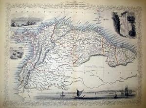
Maps. Map of Chile with vignettes of travelling post, the Gobernador, the Grand Square of Buenos Ayres, Water Seller of Buenos Ayres and Rattlesnake. Steel engraved map from the famous Victorian publisher John Tallis, well-known for the attractive vignette views surrounding the maps, which illustrate the peoples & customs of tha…t region. 10 x 13 1/2" plus margins. Attractive decorative border around edge, period outline color, very good condition.
Verlag: John Tallis & Co., London, 1854
Anbieter: Antipodean Books, Maps & Prints, ABAA, Garrison, NY, USAAntipodean Books, Maps & Prints, ABAA
Verkäufer/-in kontaktierenVerkäufer/-in mit 4 SternenZustand: Gebraucht
EUR 35,16
EUR 8,75 VersandVersand innerhalb von USAAnzahl: 1 verfügbar
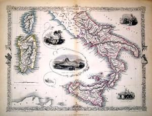
Maps. Map of Southern Italy from Rome down and including Corsica, Sardinia, and Sicily. Steel engraved map from the famous Victorian publisher John Tallis, well-known for the attractive vignette views surrounding the maps, which illustrate the peoples & customs of that region. 10 x 13 1/2" plus margins. Attractive decorative bor…der around edge, period outline color, very good condition.
Verlag: John Tallis & Co., London, 1854
Anbieter: Antipodean Books, Maps & Prints, ABAA, Garrison, NY, USAAntipodean Books, Maps & Prints, ABAA
Verkäufer/-in kontaktierenVerkäufer/-in mit 4 SternenZustand: Gebraucht
EUR 35,16
EUR 8,75 VersandVersand innerhalb von USAAnzahl: 1 verfügbar
Maps. Steel engraved map from the famous Victorian publisher John Tallis, well-known for the attractive vignette views surrounding the maps, which illustrate the peoples & customs of that region. 10 x 13 1/2" plus margins. Attractive decorative border around edge, period outline color, very good condition.

Sprache: Englisch
Verlag: J. & F. Tallis, London, Edinburgh & Dublin, 1857
Anbieter: Kaaterskill Books, ABAA/ILAB, East Jewett, NY, USAKaaterskill Books, ABAA/ILAB
Verkäufer/-in kontaktierenVerkäufer/-in mit 5 SternenZustand: Gebraucht
EUR 67,62
EUR 6,13 VersandVersand innerhalb von USAAnzahl: 1 verfügbar
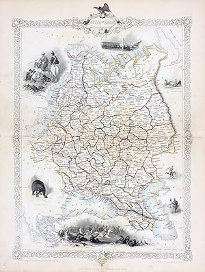
1 sheet folded. Engraved map outlined in color. 13 x 10.5 inches. Contains decorative border. Illustrations for the map were drawn by H. Warren & engraved by J.B. Allen, and depict a view of Quebec, a small group of North American Indians, a bison, and a mink (not labeled). In most editions an official Canadian seal is found in…place of the bison. Perhaps taken from from: Robert Montgomery Martin's Tallis' Illustrated Atlas, [1851-1857] according to The W. H. Pugsley Collection of Early Canadian Maps. Trimmed without loss, mounted to card stock, a few edge tears, faint soiling, verso reinforced tape, still good.
Verlag: London Printing and Publishing Company, London, 1860
- Softcover
Anbieter: Victoria Bookshop, BERE ALSTON, DEVON, Vereinigtes KönigreichVictoria Bookshop
Verkäufer/-in kontaktierenVerkäufer/-in mit 3 SternenZustand: Gebraucht - Befriedigend
EUR 51,87
EUR 11,55 VersandVersand von Vereinigtes Königreich nach USAAnzahl: 1 verfügbar
Paperback. Zustand: G-. First Thus. Minor creasing and nicks/tears to RH side edge incl small loss. this map has been folded. Very minor foxing. Decorative Black & White 19th century map for the Image Size: 350 x 245mm, 13.75 x 9.75" approx. Paper Size: 390 x 285mm, 15.25 x 11.25" approx. John Rapkin (fl. 1835-65) A nineteenth c…entury map maker and engraver, best known for his work on the Illustrated Atlas of the World 1849-53 for John Tallis and Co. noted for their beautifully decorative borders and later re-issued by the London Printing and Publishing Co. London and New York. Book.
Verlag: John Tallis & Co., London, 1854
Anbieter: Antipodean Books, Maps & Prints, ABAA, Garrison, NY, USAAntipodean Books, Maps & Prints, ABAA
Verkäufer/-in kontaktierenVerkäufer/-in mit 4 SternenZustand: Gebraucht
EUR 39,67
EUR 8,75 VersandVersand innerhalb von USAAnzahl: 1 verfügbar
Maps. Steel engraved map from the famous Victorian publisher John Tallis, well-known for the attractive vignette views surrounding the maps, which illustrate the peoples & customs of that region. 10 x 13 1/2" plus margins. Attractive decorative border around edge, period outline color, slightly foxed, o/w good condition.
Verlag: John Tallis & Co., London, 1854
Anbieter: Antipodean Books, Maps & Prints, ABAA, Garrison, NY, USAAntipodean Books, Maps & Prints, ABAA
Verkäufer/-in kontaktierenVerkäufer/-in mit 4 SternenZustand: Gebraucht
EUR 39,67
EUR 8,75 VersandVersand innerhalb von USAAnzahl: 1 verfügbar
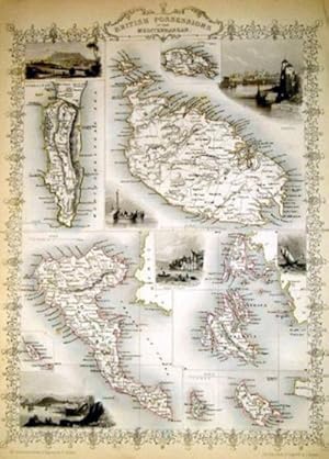
Maps. Map of Britain's possessions in the Mediterranean including Gibraltar, Malta, Corfu, and others. Steel engraved map from the famous Victorian publisher John Tallis, well-known for the attractive vignette views surrounding the maps, which illustrate the peoples & customs of that region. 10 x 13 1/2" plus margins. Attractive… decorative border around edge, period outline color, very good condition.
Sprache: Englisch
Verlag: The London Printing and Publishing Company - Limited, London and New York, 1850
- Hardcover
- Erstausgabe
Anbieter: Arroyo Seco Books, Pasadena, Member IOBA, Pasadena, CA, USAArroyo Seco Books, Pasadena, Member IOBA
Verkäufer/-in kontaktierenVerkäufer/-in mit 4 SternenVerbandsmitglied: IOBA
Zustand: Gebraucht - Befriedigend
EUR 536,56
EUR 7,00 VersandVersand innerhalb von USAAnzahl: 1 verfügbar
Half Leather. Zustand: Good. First Edition Thus. Two Volumes, Three Quarter Leather. Volume 1: 944 Pp With 30 Uncolored Plates And One Colored Map "Mexico, California, And Texas: The Newly Discovered Gold Districts". Volume Ii: 784 Pp With Two Colored Maps Of Canada, And 22 Colored Plates, All With Yellow Borders And Nice Origin…al Color Throughout. The Map Of Mexico And California, Tipped In But Neatly Loosened And Detached (Without Intention) And Usually Not Present, Has Nicely Detailed Illustrations Of The Ruins At Uxmal, Yucatan, Mexican Peasantry, And Gold Washing, And Outlines The Gold Districts Of The U S And Mexico In Yellow. No Date Of Publication Indicated But Presumably 1850. Bindings Poor, Three Of Four Boards Detached, Spines Perished, Boards Very Worn And Frayed, Deserving Of An Expensive Rebind. Contents Near Fine, Clean, Maps Perfectly Preserved. Volume I With Additional Illustrated Title Page, Showing Penn's Treaty, Painted By Benjamin West And Here Engraved By J. Rogers. This Greatly Enlarged Fourth Edition With The Colored California Gold Map Is Uncommon, About 7 Holdings Shown In Worldcat; It Is Not Listed In Carl Wheat's "The Maps Of The California Gold Region 1848 - 1857", Nor In The Addendum To The 1997 Martino Reprint Of That Book. 3 Colored Maps, 22 Colored Plates, 30 Uncolored Plates (illustrator).
Verlag: John Tallis & Co., London, 1854
Anbieter: Antipodean Books, Maps & Prints, ABAA, Garrison, NY, USAAntipodean Books, Maps & Prints, ABAA
Verkäufer/-in kontaktierenVerkäufer/-in mit 4 SternenZustand: Gebraucht
EUR 45,08
EUR 8,75 VersandVersand innerhalb von USAAnzahl: 1 verfügbar
Maps. Steel engraved map from the famous Victorian publisher John Tallis, well-known for the attractive vignette views surrounding the maps, which illustrate the peoples & customs of that region. 10 x 13 1/2" plus margins. Attractive decorative border around edge, period outline color, slt. marks at fold, o/w good condition.


