
Gesamtpreis (1 Artikel Artikel):
Versandziel:

pollacchi (24 Ergebnisse)
Direkt zu den wichtigsten Suchergebnissen
Suchfilter
Produktart
- Alle Product Types
- BŘcher (24)
- Magazine & Zeitschriften (Keine weiteren Ergebnisse entsprechen dieser Verfeinerung)
- Comics (Keine weiteren Ergebnisse entsprechen dieser Verfeinerung)
- Noten (Keine weiteren Ergebnisse entsprechen dieser Verfeinerung)
- Kunst, Grafik & Poster (Keine weiteren Ergebnisse entsprechen dieser Verfeinerung)
- Fotografien (Keine weiteren Ergebnisse entsprechen dieser Verfeinerung)
- Karten (Keine weiteren Ergebnisse entsprechen dieser Verfeinerung)
- Manuskripte & Papierantiquitńten (Keine weiteren Ergebnisse entsprechen dieser Verfeinerung)
Zustand Mehr dazu
- Neu (11)
- Wie Neu, Sehr Gut oder Gut Bis Sehr Gut (3)
- Gut oder Befriedigend (2)
- Ausreichend oder Schlecht (Keine weiteren Ergebnisse entsprechen dieser Verfeinerung)
- Wie beschrieben (8)
Einband
Weitere Eigenschaften
- Erstausgabe (2)
- Signiert (Keine weiteren Ergebnisse entsprechen dieser Verfeinerung)
- Schutzumschlag (Keine weiteren Ergebnisse entsprechen dieser Verfeinerung)
- Angebotsfoto (12)
Sprache (3)
Gratisversand
- Kostenloser Versand nach USA (Keine weiteren Ergebnisse entsprechen dieser Verfeinerung)
Land des Verkńufers
Verkńuferbewertung
-

Lecture Des Cartes Anglaises & Des ╔tats-Unis: Indications Linguistiques, GÚographiques: Et Topographiques (Histoire) (French Edition)
Anbieter: Ria Christie Collections, Uxbridge, Vereinigtes K÷nigreich
Verkńuferbewertung 5 von 5 Sternen

EUR 21,64
EUR 13,85 Versand
Versand von Vereinigtes K÷nigreich nach USAAnzahl: Mehr als 20 verfŘgbar
In den WarenkorbZustand: New. In.
-

The Crystal Portal to Self Renewal
Anbieter: Chapter 1, Johannesburg, GAU, SŘdafrika
Verkńuferbewertung 5 von 5 Sternen
paperback. Zustand: Fine. a rather much neat and clean copy. quite presentable. contents are intact and presentable. fine condition. [SK]. Our orders are shipped using tracked courier delivery services.
-

Wang Bing's Filmmaking of the China Dream: Narratives, Witnesses and Marginal Spaces
Anbieter: Majestic Books, Hounslow, Vereinigtes K÷nigreich
Verkńuferbewertung 4 von 5 Sternen

EUR 63,82
EUR 7,51 Versand
Versand von Vereinigtes K÷nigreich nach USAAnzahl: 3 verfŘgbar
In den WarenkorbZustand: New.
-

Cartes-index - glossaire - documents - annexes - Rapport gÚnÚral
Verlag: Publications du comitÚ national mÚtropolitain du centenaire de l'algÚrie, 1921
Anbieter: crealivres, La fontennelle, Frankreich
Verkńuferbewertung 5 von 5 Sternen
Zustand: Good. Envoi rapide Bon Etat. collection cahiers du centenaire de l'algÚrie #12. in12. 1921. brochÚ. 72 pages. Tache brune sur dos ( reliure agrafÚe -agrafes rouillÚes ). Good.
-

Cartes-Index, Glossaire, Documents annexes, Rapport gÚnÚral - Cahiers du Centenaire de l'AlgÚrie XII
Anbieter: Librairie Laurencier, Bordeaux, AQUIT, Frankreich
Verkńuferbewertung 4 von 5 Sternen
Publications du ComitÚ National MÚtropolitain du Centenaire de l'AlgÚrie, 1930. In-8 brochÚ, 72 p. + 5 cartes dÚpliantes en couleurs. Bon Útat.
-
Wang Bing's Filmmaking Of The China Dream: Narratives, Witnesses And Marginal Spaces
Anbieter: Revaluation Books, Exeter, Vereinigtes K÷nigreich
Verkńuferbewertung 5 von 5 Sternen
EUR 80,40
EUR 11,56 Versand
Versand von Vereinigtes K÷nigreich nach USAAnzahl: 2 verfŘgbar
In den WarenkorbPaperback. Zustand: Brand New. 242 pages. 9.18x6.12x9.21 inches. In Stock.
-
Wang Bing's Filmmaking of the China Dream: Narratives, Witnesses and Marginal Spaces (Critical Asian Cinemas)
Anbieter: Kennys Bookstore, Olney, MD, USA
Verkńuferbewertung 5 von 5 Sternen
Zustand: New. 2025. 1st Edition. paperback. . . . . . Books ship from the US and Ireland.
-

EUR 74,13
EUR 48,99 Versand
Versand von Deutschland nach USAAnzahl: Mehr als 20 verfŘgbar
In den WarenkorbZustand: New.
-
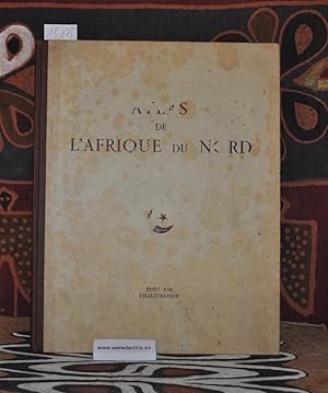
Atlas de l'Afrique du nord.
Sprache: Englisch
Verlag: Paris : L'Illustration, 1939., 1939
Anbieter: Antiquariat Welwitschia Dr. Andreas Eckl, Bochum, NRW, Deutschland
Verkńuferbewertung 5 von 5 Sternen
Original-Pappeinband, 41 x 32 cm, 31 Blńtter. Kurzer Textteil und 12 meist doppelblattgro▀e Karten. Einband berieben (siehe Bild), sehr kleiner handschr. Name auf leerem Vorsatz, gutes, sauberes Exemplar. Buch.
-

EUR 26,72
EUR 48,99 Versand
Versand von Deutschland nach USAAnzahl: Mehr als 20 verfŘgbar
In den WarenkorbZustand: New.
-

Wang Bing's Filmmaking of the China Dream: Narratives, Witnesses and Marginal Spaces (Critical Asian Cinemas) Hardcover ? May 15, 2021
Anbieter: Majestic Books, Hounslow, Vereinigtes K÷nigreich
Verkńuferbewertung 4 von 5 Sternen
EUR 166,22
EUR 7,51 Versand
Versand von Vereinigtes K÷nigreich nach USAAnzahl: 3 verfŘgbar
In den WarenkorbZustand: New.
-
Wang Bing's Filmmaking of the China Dream (Critical Asian Cinemas)
Anbieter: Ria Christie Collections, Uxbridge, Vereinigtes K÷nigreich
Verkńuferbewertung 5 von 5 Sternen
EUR 163,36
EUR 13,85 Versand
Versand von Vereinigtes K÷nigreich nach USAAnzahl: Mehr als 20 verfŘgbar
In den WarenkorbZustand: New. In.
-

EUR 129,93
EUR 48,99 Versand
Versand von Deutschland nach USAAnzahl: Mehr als 20 verfŘgbar
In den WarenkorbGebunden. Zustand: New.
-
Wang Bing's Filmmaking of the China Dream: Narratives, Witnesses, and Marginal Spaces
Anbieter: Revaluation Books, Exeter, Vereinigtes K÷nigreich
Verkńuferbewertung 5 von 5 Sternen
EUR 193,49
EUR 14,45 Versand
Versand von Vereinigtes K÷nigreich nach USAAnzahl: 2 verfŘgbar
In den WarenkorbHardcover. Zustand: Brand New. 246 pages. 9.75x6.50x0.75 inches. In Stock.
-
Wang Bing s Filmmaking of the China Dream: Narratives, Witnesses and Marginal Spaces
Sprache: Englisch
Verlag: Amsterdam University Press, 2021
ISBN 10: 9463721835 ISBN 13: 9789463721837
Anbieter: Kennys Bookstore, Olney, MD, USA
Verkńuferbewertung 5 von 5 Sternen
EUR 229,05
EUR 9,13 Versand
Versand innerhalb von USAAnzahl: Mehr als 20 verfŘgbar
In den WarenkorbZustand: New. 2021. Hardcover. . . . . . Books ship from the US and Ireland.
-

La Biennale di Venezia. 64. Mostra Internazionale d'Arte Cinematografica. 22. Settimana internazionale della critica
Verlag: Electa, MILANO, 2007
ISBN 10: 8837056613 ISBN 13: 9788837056612
Anbieter: Biblioteca di Babele, Tarquinia, VT, Italien
Verkńuferbewertung 5 von 5 Sternen
Zustand: BUONO USATO. INTERLINGUE Pubblicazione edita in occasione della mostra internazionale d'arte cinematografica, 22. settimana internazionale della critica, tenutasi in Venezia, 30 agosto-8 settembre 2007, copertina illustrata con patinato imperfetto, pigmento ingiallito e ombrato da polvere, segnata da comuni sgualciture da compressione, fogli ben tenuti, completati da immagini fotografiche. N. pag. 105.
-
Atlas de la France et de ses colonies. DressÚ et dessinÚ par le Commandant P. Pollacchi.
Verlag: France editÚ par L'Illustration, 1934
Anbieter: Libretto Antiquariat & mundart.ch, Langnau i.E., BE, Schweiz
Verkńuferbewertung 4 von 5 Sternen
Halblederband, avec 21 cartes couleurs, unpaginiert, Sprache Franz÷sisch, 21 x 32 cm, sch÷nes Exemplar.
-

Lecture des Cartes Russes. Indications linguistiques, gÚographiques et topographiques.
Verlag: CHAPELOT R. et Cie., 1907
Couverture rigide. Zustand: bon. RO80105188: 1907. In-4. Cartonnage d'Úditeurs. Bon Útat, Couv. lÚgŔrement passÚe, Dos satisfaisant, IntÚrieur acceptable. IX + 90 pages + 3 tableaux dÚpliants. Etiquette de code sur la coiffe en-tŕte et tampons de bibliothŔque sur la page de titre. . . . Classification Dewey : 947-Europe de l'Est, URSS.
-
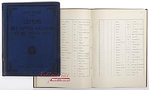
Lecture des Cartes Anglaises & des ╔tats-Unis. Indications linguistiques, gÚographiques et topographiques. (Dazu): Das Lesen englischer Karten und jener der Vereinigten Staaten. Sprachlicher, geographischer und topographischer FŘhrer von Capitaine P. Pollacchi. (Manuskript in sch÷n leserlicher Lateinschrift. ▄bersetzung und Abschrift von Hauptmann Hofrichter, beendet am 28 Jńnner 1912 in Wien). 2 Bńnde.
Verlag: Paris, R. Chapelot, 1908; resp.: 1911/1912., 1912
Anbieter: Antiquariat MEINDL & SULZMANN OG, Wien - Vienna, Ísterreich
Verkńuferbewertung 5 von 5 Sternen
4░. Mit 5 Tafeln. 158 SS., 2 Bl.; resp.: 224 SS. (Manuskript). Illustr. OLn. (lńdiert, fleckig, beschabt u. besto▀en) u. Ln. d. Zt. mit goldgepr. Titel a. d. Vorderdeckel (etwas besto▀en). Table des MatiŔres: "Notions GÚnÚrales sur les Services GÚographiques. Signes, abrÚviations et termes topographiques et gÚographiques employÚs dans les cartes Anglaises et des ╔tats-Unis. Signes, abrÚviations et termes employÚs dans les cartes marines. Transcription francaise des noms chinois Úcrits d aprŔs les mÚthodes anglaises. Nomenclature des ╔chelles en miles des cartes Anglaises et des ╔tats-Unis, les plus usitÚes et leur transformation en Úchelles mÚtriques. Conversion en mŔtres et fractions mÚtriques des pieds, yards, fathoms et miles terrestres anglais. Mesures et monnaies de la Grande Bretagne et des ╔tats-Unis avec leurs Úvaluations en mesures et monnaies francaises. Tableau des signes conventionnels".- Geschenk des Verfassers "Don de l Auteur" an die Bibliothek des Militńrgeographischen Instituts in Wien, wo die Schrift ins Deutsche Řbersetzt und als Abschrift beigefŘgt wurde. Beim franz÷s. Titelblatt der hs. Vermerk: "Deutsche ▄bersetzung ausgefŘhrt von Herrn Hauptmann Hofrichter im Jahre 1911, unter gleicher Nummer".- Ausgeschiedenes Exemplar aus dem Militńrgeographischen Institut (mit Bibl.-Schildchen u. Bibl.-Stempel).- Papier etwas gebrńunt.
-
Atlas Colonial Francais. Colonies, Protectorats et Pays sous mandat. Cartes et texte du Commandant.
Verlag: Paris, ╔d. par L'Illustration, 1929
Anbieter: Antiquariat Bń▀ler, Vohenstrauss, Deutschland
Verkńuferbewertung 5 von 5 Sternen
Erstausgabe
318 S., mit zahlreichen Illustrationen, teils doppelseitigen, farbigen Karten, 2░ Band in guter Erhaltung, Einband vorwiegend sauber und unbesto▀en, Leder teilweise berieben, besonders im Kapitalbereich auch beschabt, Seiten hell und sauber, ohne Eintrńge, Buchblock fest, nur Vorsatzblatt leicht lagerspurig, im seitlichen Schnittbereich, stellenweise geringfŘgig altersfleckig, 0 Sprache: Franz÷sisch Gewicht in Gramm: 6000 OHalbleder, mit Lederecken, goldgeprńgtem Deckel- und RŘckentitel,
-
Atlas colonial franšais. Colonies, Protectorats et Pays sous mandat. Cartes et texte du commandant P. Pollacchi. 3e Údition, revue et mise Ó jour
Verlag: Paris, l'Illustration, Paris, 1937
Anbieter: Librairie de l'Avenue - Henri Veyrier, Saint-Ouen, FR, Frankreich
Verkńuferbewertung 5 von 5 Sternen
Couverture rigide. Zustand: Bon Útat. In-folio 41 x 31 cm. Reliure Úditeur simili-cuir havane, report du titre dorÚ sur le dos lisse muet et sur le premier plat de couverture ornÚ d'un motif, 325 pp. dont 55 cartes, nombreuses gravures, index alphabÚtique, liste des cartes, table des matiŔres. tŕte et pied de dos rÚparÚs sinon exemplaire en bon Útat.
-
Atlas Colonial Franšais. Colonies, Protectorats et Pays sous mandat. Cartes et texte du Commandant.
Verlag: ╔d. par L'Illustration,, Paris,, 1929
Anbieter: Llibreria AntiquÓria Delstres, Canet de Mar, B, Spanien
Verkńuferbewertung 4 von 5 Sternen
Erstausgabe
PRIMERA EDICIËN. Hay dos reediciones mßs, una del a˝o 1931 y otra de 1937. 318 pßginas, 1 hoja. Frontispicio "Tableau d'ensemble des races peuplant les Colonies Franšaises". Ilustrado con 39 mapas a doble pßgina y 18 a plena pßgina, a color, y aproximadamente 261 fotografÝas y heliograbados dentro de texto, las fotografÝas de vistas realizadas por la Compa˝Ýa AÚrea Francesa, y varios fotˇgrafos, entre ellos: Rouffet, Geiser, Bourgoin, Roure, Bourgeois, FrÚchon, J. Clair-Guyot, Pavia, etc. Encuadernaciˇn en holandesa medial piel y puntas, con cartonÚ estampado con el tÝtulo en el plano, lomo con hierros dorados, ligeramente rozada. Hojas de guarda pintadas al agua. Buen estado de conservaciˇn. 41x32 cm.
-
Atlas de l'Afrique du Nord.
Anbieter: SomeThingz. Books etcetera., Averbode, Belgien
Verkńuferbewertung 5 von 5 Sternen
Paris L'Illustration 1939 ReliÚ, 6pp. de texte et 16 planches double-page dont la majoritÚ en couleurs, 32.5x41.5cm., Útat acceptable / bon (couverture dÚfraichie et avec des taches, intÚrieure et planches en trŔs bon Útat). Cet atlas, prÚfacÚ par Max Sorre, offre une vision complŔte et soignÚe de l'Afrique du Nord - AlgÚrie, Tunisie, Maroc - combinant cartes physiques, politiques, Úconomiques et touristiques. Il s'adresse Ó tous ceux qui souhaitent comprendre les rÚalitÚs gÚographiques, administratives et culturelles de cette rÚgion au seuil de transformations majeures. Les 16 planches en couleurs, dressÚes par P. Pollacchi, R. de Flotte de Roquevaire et H. Mady, illustrent avec prÚcision les divers aspects naturels, humains et Úconomiques de ces territoires. Cet ouvrage constitue un atlas rÚgional illustrÚ, alliant rigueur cartographique et clartÚ pÚdagogique. AprŔs une prÚface de Max Sorre contextualisant l'importance gÚopolitique de l'Afrique du Nord en 1939, Georges Hardy propose une synthŔse historique et gÚographique, mise en valeur par la juxtaposition de cartes thÚmatiques: politique, physique, Úconomique, touristique. Chaque territoire (AlgÚrie et ses dÚpartements, Tunisie, Maroc) est prÚsentÚ selon plusieurs facettes: structuration administrative, Úvolution historique (1900-1938), ressources Úconomiques, voies de communication et attraits touristiques. L'irruption des cartes colorÚes sert Ó saisir les dynamiques territoriales et la diversitÚ des paysages, et cet atlas s'inscrit pleinement dans l'effort Úducatif colonial d'alors, visant Ó structurer la connaissance gÚographique pour un public lettrÚ et professionnel.
-
Atlas colonial franšais. Colonies, protectorat et pays sous mandat.
Anbieter: Librairie-Bouquinerie Le PŔre PÚnard, Lyon, Frankreich
Verkńuferbewertung 5 von 5 Sternen
Editions L'Illustration - 1929 - Grand in-folio, reliure de l'Úditeur, demi basane Ó coins, titre et dÚcoration sur le premier plat - 320 pages - 56 cartes en couleurs et trŔs nombreuses illustrations et reproductions photographiques en N&B in et hors-texte Bon Útat dans l'ensemble - Frottements sur la reliure - Coiffes ÚrodÚes - Frottements et dÚchirures sur le cuir au niveau du mors du 4Ŕme plat - TrŔs bon Útat intÚrieur.


