Pitt moses (72 Ergebnisse)
Sprache: Englisch
Verlag: Oxford, Moses Pitt, 1682
- Softcover
- Erstausgabe
Anbieter: Antiquariat Steffen Völkel GmbH, Seubersdorf, DeutschlandAntiquariat Steffen Völkel GmbH
Verkäufer/-in kontaktierenVerkäufer/-in mit 5 SternenZustand: Gebraucht
EUR 6.500,00
EUR 30,00 VersandVersand von Deutschland nach USAAnzahl: 1 verfügbar
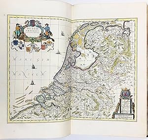
Large-Folio (525 x 310mm.). Contemporary mottled sheep. 244, (42) pp. With engraved allegorical additional title, letterpress title printed in red and black with engraved vignette, engraved portrait of James II, dedication leaf, 41 engraved hand-coloured maps, all but one double-page. Moses Pitt planned a 12 vols. Atlas, but onl…y 4 volumes were published. Vol.1 dedicated to the World and Northern Regions; Vol. 2 & 3 to Germany; Vol. 4 to the Netherlands. A very good, complete copy of the fourth volume of Pitts atlas dedicated exclusively to the Low Countries, the Netherlands, Belgium and Luxemburg. Laid down on the front paste-down is a contemporary receipt for the book from 22th June 1682: This fourth volume of the English Atlas, costing £24, with further charges for freight and binding, bringing the final total to £35 16s." -- -- -- Condition: binding a bit rubbed and with some abrasions, otherwise a very good copy with all maps in very good condition. -- -- -- References: Tooley - "Dictionnary of Mapmakers" p. 508/9; E.G.R. Taylor - "The English Atlas of Moses Pitt, 1680-83," Geographical Journal 95, 4 (April 1940), pp. 292-299; Lloyd Arnold Brown - "The World Encompassed". (Baltimore, 1952), n. 172; Rodney W. Shirley - "The Mapping of the World" (London, 1983), n. 504. // Wir, das Antiquariat Steffen Völkel, kaufen und verkaufen alte Bücher, Handschriften, Zeichnungen, Autographen, Grafiken und Fotografien. Wir sind stets am Ankauf von kompletten Bibliotheken, Sammlungen und Nachlässen interessiert. Sprache: Englisch Gewicht in Gramm: 550.

Verlag: Z. Tebinka, New York, 1943
- Softcover
Anbieter: ERIC CHAIM KLINE, BOOKSELLER (ABAA ILAB), Santa Monica, CA, USAERIC CHAIM KLINE, BOOKSELLER (ABAA ILAB)
Verkäufer/-in kontaktierenVerkäufer/-in mit 3 SternenZustand: Gebraucht
EUR 112,55
EUR 4,37 VersandVersand innerhalb von USAAnzahl: 1 verfügbar
Softcover. Zustand: g+ to near fine. Reprint. Large elephant folio. [2] 28pp. Half red cloth over illustrated tan paper wrappers, with black lettering on the front cover. This work is a full and finely produced facsimile reprint of the incredibly scarce "English Atlas," originally created and published by Moses Pitt (c. 16391697…), in Oxford 1680. Only the first volume of the set is reprinted here, focusing on Northern regions including Russian, Poland and Scandinavia. Originally Pitt had intended to issue a 12 volume set, all under the auspices of the Royal Society, but ultimately only was able to issue 4 volumes before the project collapsed due to financial difficulties. The work contains 4 detailed fold-out maps each measuring 23x22", showing Poland, Lithuania, Ukraine and Western areas of Russia during the period. Text throughout printed in a two-column format. Introductory text at the front of the reprint, discussing the history of the work. Wrappers with some age toning to the covers, as well as some light rubbing to extremities. Top right corner of cover lightly chipped and a stain at the bottom right. A few light abrasions. Wrappers in good+, interior in near fine condition overall.
Verlag: Pitt Moses, 1639-1697, 1697
- Hardcover
Anbieter: Hammelburger Antiquariat, Hammelburg, DeutschlandHammelburger Antiquariat
Verkäufer/-in kontaktierenVerkäufer/-in mit 5 SternenZustand: Gebraucht - Gut
EUR 290,00
EUR 30,00 VersandVersand von Deutschland nach USAAnzahl: 1 verfügbar
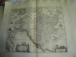
Hardcover. Zustand: very good. Ducatus Holsatiae descriptio, anno 1680, Moses Pitt, Kupferstich, Blatt: 60x70 cm., gedruckt auf dickem Papier, Mittelfalz etwas gebräunt. Begrenzt im Nordwesten durch Husum, Nordstrand, Amrum, im Nordosten durch Fehmarn, im Süden durch Hamburg und die Wesermündung mit dem Jadebusen.
Verlag: Pitt Moses, 1639-1697, 1697
- Hardcover
Anbieter: Hammelburger Antiquariat, Hammelburg, DeutschlandHammelburger Antiquariat
Verkäufer/-in kontaktierenVerkäufer/-in mit 5 SternenZustand: Gebraucht - Gut
EUR 290,00
EUR 30,00 VersandVersand von Deutschland nach USAAnzahl: 1 verfügbar
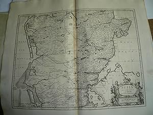
Hardcover. Zustand: very good. Jutia Australis, anno 1680, Moses Pitt, copperengraving, size of the sheet: 60x70 cm., printed on thick paper, wide margins, little brownish centerfold.
Verlag: Pitt Moses, 1639-1697, 1697
- Hardcover
Anbieter: Hammelburger Antiquariat, Hammelburg, DeutschlandHammelburger Antiquariat
Verkäufer/-in kontaktierenVerkäufer/-in mit 5 SternenZustand: Gebraucht - Gut
EUR 300,00
EUR 30,00 VersandVersand von Deutschland nach USAAnzahl: 1 verfügbar
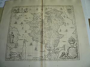
Hardcover. Zustand: very good. Selandiae in Regno Daniae Insulae Chorographica Descriptio Map Maker: Moses Pitt, edited anno 1680, plate size: 44x53 cm. (printed area), little brownish on centerfold, printed on thick paper Detailed regional map centered on Syaelland with the topography, cities and towns meticulously engraved.
Verlag: Pitt Moses, 1639-1697, 1697
- Hardcover
Anbieter: Hammelburger Antiquariat, Hammelburg, DeutschlandHammelburger Antiquariat
Verkäufer/-in kontaktierenVerkäufer/-in mit 5 SternenZustand: Gebraucht - Gut
EUR 300,00
EUR 30,00 VersandVersand von Deutschland nach USAAnzahl: 1 verfügbar
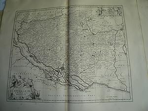
Hardcover. Zustand: very good. Ducatus Stormariae, Holsatiae, anno 1680, Moses Pitt, Originale Landkarte, Blatt: 60x70 cm., gute Erhaltung, gedruckt auf dickem Papier.
Verlag: Pitt Moses, 1639-1697, 1697
- Hardcover
Anbieter: Hammelburger Antiquariat, Hammelburg, DeutschlandHammelburger Antiquariat
Verkäufer/-in kontaktierenVerkäufer/-in mit 5 SternenZustand: Gebraucht - Gut
EUR 330,00
EUR 30,00 VersandVersand von Deutschland nach USAAnzahl: 1 verfügbar
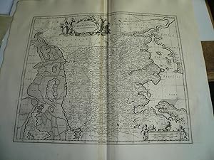
Hardcover. Zustand: very good. Ducatus Slesvicensis pars septentrionalis, anno 1680, Moses Pitt, Kupferstich, Blatt: 60x70 cm., gedruckt auf dickem Papier, sauber und fleckenfrei. Zeigt Schleswig.
 Weitere Bilder
Verlag: Pitt Moses, 1639-1697, 1697
- Hardcover
Anbieter: Hammelburger Antiquariat, Hammelburg, DeutschlandHammelburger Antiquariat
Verkäufer/-in kontaktierenVerkäufer/-in mit 5 SternenZustand: Gebraucht - Gut
EUR 330,00
EUR 30,00 VersandVersand von Deutschland nach USAAnzahl: 1 verfügbar
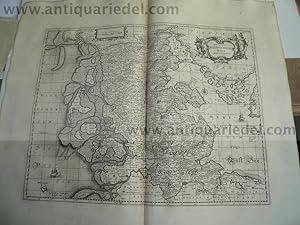
Hardcover. Zustand: very good. Ducatus Slesvicensis Australis pars, anno 1680, Moses Pitt, Kupferstich, im Westen mit Sylt, im Osten mit einem Teil von Fünen. Sauber und breitrandig, geringe Bräunung der Mittelfalz.
Verlag: Pitt Moses, 1639-1697, 1697
- Hardcover
Anbieter: Hammelburger Antiquariat, Hammelburg, DeutschlandHammelburger Antiquariat
Verkäufer/-in kontaktierenVerkäufer/-in mit 5 SternenZustand: Gebraucht - Gut
EUR 330,00
EUR 30,00 VersandVersand von Deutschland nach USAAnzahl: 1 verfügbar
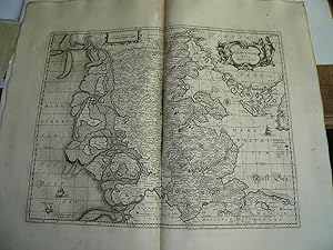
Hardcover. Zustand: very good. Ducatus Sleswicensis nova descriptio, anno 1680, Moses Pitt, Kupferstich, Blatt: 60x70 cm., gedruckt auf dickem Papier, Mittelfalz etwas gebräunt. Zeigt Schleswig-Holstein mit Dänemark.
Verlag: Pitt Moses, 1639-1697, 1697
- Hardcover
Anbieter: Hammelburger Antiquariat, Hammelburg, DeutschlandHammelburger Antiquariat
Verkäufer/-in kontaktierenVerkäufer/-in mit 5 SternenZustand: Gebraucht - Gut
EUR 350,00
EUR 30,00 VersandVersand von Deutschland nach USAAnzahl: 1 verfügbar
Hardcover. Zustand: very good. Nova et Accurata descriptio totius Fionae vulgo Funen. - Janssonius J. - Pitt Moses, 1680. Old map of Denmark - Fyn by J. Janssonius, published by Moses Pitt and J. Janssonius-Waesberge Date of this map: 1680 Copper engraving Size: 40.5 x 51cm sheet: 60x68 cm. From: The English Atlas. Oxford, Moses… Pitt, 1680. (Van der Krogt 1, 451).
Verlag: Pitt Moses, 1639-1697, 1697
- Hardcover
Anbieter: Hammelburger Antiquariat, Hammelburg, DeutschlandHammelburger Antiquariat
Verkäufer/-in kontaktierenVerkäufer/-in mit 5 SternenZustand: Gebraucht - Gut
EUR 350,00
EUR 30,00 VersandVersand von Deutschland nach USAAnzahl: 1 verfügbar
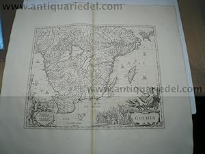
Hardcover. Zustand: very good. Gothia - J. Jansonius - Pitt Moses, 1680. Old map of Sweden - Götaland by J. Janssonius, published by Pitt Moses & J. Janssonius-Waesberge Date of this map: 1680 Copper engraving Size: 41.5 x 53 cm., size of the sheet: 60x68 cm., printed on thick paper, wide margins, little brownish on centerfold.

Verlag: Pitt Moses, 1639-1697, 1697
- Hardcover
Anbieter: Hammelburger Antiquariat, Hammelburg, DeutschlandHammelburger Antiquariat
Verkäufer/-in kontaktierenVerkäufer/-in mit 5 SternenZustand: Gebraucht - Gut
EUR 350,00
EUR 30,00 VersandVersand von Deutschland nach USAAnzahl: 1 verfügbar
Hardcover. Zustand: very good. Scania, vulgo Schonen - Janssonius J. - Pitt Moses, 1680. Old map of Sweden - Skane by J. Janssonius, published by Moses Pitt and J. Janssonius-Waesberge Date of this map: 1680 Copper engraving Size: 45.5 x 54cm., sheet: 60x68 cm. Printed on thick paper, wide margins, little brownish centerfold.

Verlag: Pitt Moses, 1639-1697, 1697
- Hardcover
Anbieter: Hammelburger Antiquariat, Hammelburg, DeutschlandHammelburger Antiquariat
Verkäufer/-in kontaktierenVerkäufer/-in mit 5 SternenZustand: Gebraucht - Gut
EUR 350,00
EUR 30,00 VersandVersand von Deutschland nach USAAnzahl: 1 verfügbar
Hardcover. Zustand: very good. Dwina River, anno 1690, map Moses Pitt "Dwinae Fluvii nova discriptio" - Der Verlauf des Flusses Dwina von der Quelle bis zur Mündung in das Weiße Meer bei Archangelsk, in drei übereinanderliegenden Darstellungen. - kolorierte Kupferstichkarte Moses Pitt, ca. 1690 Blattgröße: ca. 55 x 63 cm Ansicht…: ca. 46,5 x 54,5 cm - Mittelfalz eingerissen, leichte Knickspuren, etwas fleckig und zum Rand hin gebräunt -.
 Weitere Bilder
Verlag: Pitt Moses, 1639-1697, 1697
- Hardcover
Anbieter: Hammelburger Antiquariat, Hammelburg, DeutschlandHammelburger Antiquariat
Verkäufer/-in kontaktierenVerkäufer/-in mit 5 SternenZustand: Gebraucht - Gut
EUR 400,00
EUR 30,00 VersandVersand von Deutschland nach USAAnzahl: 1 verfügbar
Hardcover. Zustand: very good. Nova Totius Livoniae accurata Descriptio, anno 1680, M.Pitt Map Maker: Moses Pitt London / 1680 Map of Estonia, Latvia, Northern Lithuania, and Baltic, published in London. Size of the sheet: 60x70 cm., printed on thick paper, wide margins, little brownish centerfold.
 Weitere Bilder
Verlag: Pitt Moses, 1639-1697, 1697
- Hardcover
Anbieter: Hammelburger Antiquariat, Hammelburg, DeutschlandHammelburger Antiquariat
Verkäufer/-in kontaktierenVerkäufer/-in mit 5 SternenZustand: Gebraucht - Gut
EUR 400,00
EUR 30,00 VersandVersand von Deutschland nach USAAnzahl: 1 verfügbar
Hardcover. Zustand: very good. Taurica Chersonesus, Hodie Przecopsa, 1680, Moses Pitt, map "Taurica Chersonesus, Hodie Przecopsca, et Gazara dicitur." Jansson/Pitt Antique map chart Taurica Chersonesus Hodie Przecopsca et Gazara dicitur. This map of the region north of the Black Sea is based on Mercator's cartography. The interi…or is filled with large forests and mountains. It is embellished with two cartouches surrounded by figures. The plate was originally engraved by Jan Jansson. After his death it was inherited by his son-in-law, known as Jansson-Waesberg, who published it in conjunction with Moses Pitt. Size of the sheet: 58x67 cm., printed on thick paper, wide margins, only little brownish on centerfold.

Verlag: Pitt Moses, 1639-1697, 1697
- Hardcover
Anbieter: Hammelburger Antiquariat, Hammelburg, DeutschlandHammelburger Antiquariat
Verkäufer/-in kontaktierenVerkäufer/-in mit 5 SternenZustand: Gebraucht - Gut
EUR 450,00
EUR 30,00 VersandVersand von Deutschland nach USAAnzahl: 1 verfügbar
Hardcover. Zustand: very good. Palatinatus Posnaniensis in Maiori Polonia Primarii nova delinatio, Moses Pitt, anno 1680 53.4 x 45.8 cm Uncommon and very beautifully engraved map of the western part of Poland including the cities of Poznan and Glogow. The map is attributed to Gerard Mercator, but was copied from Blaeu's map of t…he same title. Finely engraved to illustrate the rivers, forests, lowlands, lakes, cities, towns and villages. Each corner is richly adorned with cartouches, armorial shields, figures, livestock and putti. Little brownish centerfold. Size of the sheet: 60x68 cm. Printed on thick paper, wide margins, some folds.

Verlag: Pitt Moses, 1639-1697, 1697
- Hardcover
Anbieter: Hammelburger Antiquariat, Hammelburg, DeutschlandHammelburger Antiquariat
Verkäufer/-in kontaktierenVerkäufer/-in mit 5 SternenZustand: Gebraucht - Gut
EUR 450,00
EUR 30,00 VersandVersand von Deutschland nach USAAnzahl: 1 verfügbar
Hardcover. Zustand: very good. Russiae vulgo moscovia anno 1680, Moses Pitt, map, wide margins, printed on thick paper, size of the sheet: 60x68 cm., only little brownish centerfold.

Verlag: Pitt Moses, 1639-1697, 1697
- Hardcover
Anbieter: Hammelburger Antiquariat, Hammelburg, DeutschlandHammelburger Antiquariat
Verkäufer/-in kontaktierenVerkäufer/-in mit 5 SternenZustand: Gebraucht - Gut
EUR 500,00
EUR 30,00 VersandVersand von Deutschland nach USAAnzahl: 1 verfügbar
Hardcover. Zustand: very good. Sueciae, Norvegiae, et Daniae, Nova Tabula - Janssonius J. - Pitt Moses, 1680. Date of this map: 1680 Copper engraving Size: 47 x 54.5cm., sheet: 60x68 cm., printed on thick paper, wide margins, only little brownish on centerfold. From: The English Atlas. Oxford, Moses Pitt, 1680.
Verlag: Z. Tehinka
- Hardcover
Anbieter: Wonder Book, Frederick, MD, USAWonder Book
Verkäufer/-in kontaktierenVerkäufer/-in mit 5 SternenZustand: Gebraucht - Ausreichend
EUR 1.782,58
Versand nach gratisVersand innerhalb von USAAnzahl: 1 verfügbar
Zustand: Fair. New York: Z. Tehinka, 1943. Reprint of 1680 edition. Volume 1. Folio. 28pp. Maps. Fair book. Bottom 6" of both boards dampstained. (Poland, maps, history, travel) Inquire if you need further information.
 Weitere Bilder
Verlag: London, for Moses Pitt, 1681-1683., 1683
- Hardcover
Anbieter: Antiquariat Tresor am Roemer, Frankfurt, DeutschlandAntiquariat Tresor am Roemer
Verkäufer/-in kontaktierenVerkäufer/-in mit 4 SternenZustand: Gebraucht
EUR 10.500,00
EUR 25,00 VersandVersand von Deutschland nach USAAnzahl: 1 verfügbar
2 Bände. Gr.-Fol. Gestochenes koloriertes Portrait, gestochener kolorierter Titel, 2 nn. Bl., 151 S., 40 nn. Bl.; gestochenes koloriertes Portrait, 2 nn. Bl., S. 157-312, 37 nn. Bl., mit 90 (4 gefalteten und 85 doppelblattgroßen) grenzkolorierten Kupferstichkarten. Leder der Zeit mit Rückenschild, (berieben, Gelenke und Kapitale… unterlegt). Erste und einzige Ausgabe. - Koemann II, Me 183. - Die 2 vorliegenden Bände beinhalten den vollständigen Deutschlandteil unter Einschluss der damals zum Hl. Römischen Reich gehörenden Gebiete wie, Böhmen, Österreich, Ungarn und Transylvanien. - Das nach dem 4. Band eingestellte Projekt eines englischsprachigen Atlasses basierte auf der Grundlage des "Atlas Major" von Janssonius, dessen Karten etwas überarbeitet wurden. Es finden sich jedoch auch einige Karten, die sonst nirgendwo erschienen sind, darunter die schönen Faltkarten von der Wesermündung und Baden. - Eine Karte mit Einriss, im Bug teils etwas knickfaltig, wenige Karten etwas angerändert, die Weserkarte leicht beschnitten, Ex-Libris auf Innendeckel. - Insgesamt innen sehr gutes, breitrandiges, nur minimal fleckiges Exemplar mit kolorierten Kartuschen. // Engraved coloured portrait, engraved coloured title, 2 unn. ll., 151 pp., 40 unn. ll.; engraved coloured portrait, 2 unn. ll., p. 157-312, 37 unn. ll., with 90 (4 folded and 85 double-page) border coloured engraved maps. Contemporary calf with label, (rubbed, hinges and end of spine restored). - First and only edition. Koemann II, Me 183. The 2 available volumes contain the complete part of Germany including the areas which belonged to the Holy Roman Empire, like Bohemia, Austria, Hungary and Transylvania. This project of an English speaking author, which was stopped after the publication of volume 4, is based on the "Atlas Major" of Janssonius (maps are slightly revised). But there are some more maps, which were not published elsewhere, amongst them the beautiful folding maps of the Weser river mouth and Baden. Catouches with nice colouring. One map with tearing, in the inner margins slightly creased, few maps slightly margin-spotted, map of Weser slightly trimmed. Bookplate on inside cover. Altogether a very fine copy with large margins and only a little minor foxing.
Verlag: Oxford: Jansonnius - Pitt - Swart, c.1680., 1680
- Hardcover
Anbieter: Arader Galleries - AraderNYC, New York, NY, USAArader Galleries - AraderNYC
Verkäufer/-in kontaktierenVerkäufer/-in mit 5 SternenZustand: Gebraucht
EUR 810,35
Versand nach gratisVersand innerhalb von USAAnzahl: 1 verfügbar
Hardcover. Single sheet (22 ¼ x 19 ½) Full margins showing the plate mark. (Light foxing, repair on verso). This elegant hand-colored map of the Duchy of Brabant centered on Leuven and Tienen. Around the title cartouche nine shields for the town coat of arms, that of Tienen left blank. Standing next to the cartouche is the Greek… god Apollo, playing the harp and the sun shining brightly behind him. The coat of arms of the Duchy of Brabant crown the top of the map. The left side cartouche containing the scale of miles balances out the map, with a curious interaction between a male and female figure. The woman holding cartographic tools and an atlas could perhaps be Elizabeth Verseyl, the late Nicolaes Visscher's wife. The earliest mention of Leuven ("Loven") is from 891, when a Viking army was defeated by the Frankish king Arnulf of Carinthia (see: Battle of Leuven). According to a legend the city's red and white arms depict the blood-stained shores of the river Dyle after this battle. Situated beside this river, and near to the stronghold of the Dukes of Brabant, Leuven became the most important centre of trade in the duchy between the 11th and 14th centuries. A token of its former importance as a centre of cloth manufacture is shown in that ordinary linen cloth is known in late-14th-century and 15th-century texts as lewyn (other spellings: Leuwyn, Levyne, Lewan(e), Lovanium, Louvain). In the 15th century a new golden era began with the founding of what is now the largest and oldest university in the Low Countries, the Catholic University of Leuven, in 1425. The Atlas Minor is a fine and comprehensive composite atlas, and one of a series of large atlases compiled and sold by the Visscher family of art dealers and cartographers in the 17th century. Founded by Nicholas Visscher, this work is known for the high quality of engraving, exceptionally fine ornament, and accurate geographical information. No two of the Visscher atlases seem to have been identical in content, and most contain, like this one, a selection of maps by the Visschers themselves as well as other cartographers. In this case the majority of the maps are published by Visscher. In addition to the striking world map by Allard with its black background and numerous projections, and found in the "Atlas Major" from about 1705, there are maps of the continents, regional maps of Europe, ten maps of Asia, and seven maps related to America. For more information on this map, or a warm welcome to see other maps and books of our collection at 72nd Street NYC, please contact Natalie Zadrozna.
 Weitere Bilder
Verlag: Pitt Moses, 1639-1697, 1697
- Hardcover
Anbieter: Hammelburger Antiquariat, Hammelburg, DeutschlandHammelburger Antiquariat
Verkäufer/-in kontaktierenVerkäufer/-in mit 5 SternenZustand: Gebraucht - Gut
EUR 700,00
EUR 30,00 VersandVersand von Deutschland nach USAAnzahl: 1 verfügbar
Hardcover. Zustand: very good. Nova et accurata Tabula episcopatuum Stavangriensis. Bergensis et Asloiensis Episcopatus BERGENSIS anno 1680, Moses Pitt This superb map covers the area around Bergen with graphic topographical detail. It extends to include the mountain plateau that is now the Hardangervidda National Park. It is ri…chly embellished with title and distance scale cartouches surrounded by putti, and sailing ships in the sea. Size of the sheet: 58x68 cm., printed on thick paper, wide margins, only little brownish centerfold.

Verlag: Pitt Moses, 1639-1697, 1697
- Hardcover
Anbieter: Hammelburger Antiquariat, Hammelburg, DeutschlandHammelburger Antiquariat
Verkäufer/-in kontaktierenVerkäufer/-in mit 5 SternenZustand: Gebraucht - Gut
EUR 600,00
EUR 30,00 VersandVersand von Deutschland nach USAAnzahl: 1 verfügbar
Hardcover. Zustand: very good. Episcopatus BERGENSIS anno 1680, Moses Pitt This superb map covers the area around Bergen with graphic topographical detail. It extends to include the mountain plateau that is now the Hardangervidda National Park. It is richly embellished with title and distance scale cartouches surrounded by putti…, and sailing ships in the sea. Size of the sheet: 58x68 cm., printed on thick paper, wide margins, only little brownish centerfold.
 Weitere Bilder
Verlag: Pitt Moses, 1639-1697, 1697
- Hardcover
Anbieter: Hammelburger Antiquariat, Hammelburg, DeutschlandHammelburger Antiquariat
Verkäufer/-in kontaktierenVerkäufer/-in mit 5 SternenZustand: Gebraucht - Gut
EUR 1.100,00
EUR 30,00 VersandVersand von Deutschland nach USAAnzahl: 1 verfügbar
Hardcover. Zustand: very good. Regni Norvegiae, anno 1680, Moses Pitt, Generalmap. Size of the sheet: 58x68 cm., printed on thick paper, wide margins, only little brownish centerfold. Scarce.
 Weitere Bilder
Verlag: Pitt Moses, 1639-1697, 1697
- Hardcover
Anbieter: Hammelburger Antiquariat, Hammelburg, DeutschlandHammelburger Antiquariat
Verkäufer/-in kontaktierenVerkäufer/-in mit 5 SternenZustand: Gebraucht - Gut
EUR 1.000,00
EUR 30,00 VersandVersand von Deutschland nach USAAnzahl: 1 verfügbar
Hardcover. Zustand: very good. TRACTUUM BORUSSIAE, anno 1680, Moses Pitt Tractuum Borussiae, circa Gedanum et Elbingam ab incolis Werder appellati cum adiuncta Neringia nova et elaboratissima delineatio Jansson/Pitt Superb map of the region where the Nogat and Wista Rivers flow into the Gulf of Gdansk. The map includes incredibl…e detail of the rivers, streams, forests, farms, windmills, dykes, and the fortifications at Gdansk, Malbork and Elblag. The plate was originally engraved by Jan Jansson. After his death it was inherited by his son-in-law, known as Jansson-Waesberg, who published it in conjunction with Moses Pitt. Size of the sheet: 58x68 cm., little brownish on centerfold, printed on thick paper, small restoration on centerfold.
 Weitere Bilder
Verlag: Pitt Moses, 1639-1697, 1697
- Hardcover
Anbieter: Hammelburger Antiquariat, Hammelburg, DeutschlandHammelburger Antiquariat
Verkäufer/-in kontaktierenVerkäufer/-in mit 5 SternenZustand: Gebraucht - Gut
EUR 800,00
EUR 30,00 VersandVersand von Deutschland nach USAAnzahl: 1 verfügbar
Hardcover. Zustand: very good. Magnus ducatus FINLANDIAE, anno 1680, Moses Pitt Map of Finland by J. Janssonius, published by Moses Pitt and J. Janssonius-Waesberge Magnus Ducatus Finlandiae Auct. Andrea Buraeo Sueco - Janssonius J. - Pitt Moses, 1680. Cartographer: Andrea Buraeus. Size of the sheet: 58x68 cm., printed on thick…paper, wide margins, only little brownish on centerfold.
Verlag: Pitt Moses, 1639-1697, 1697
- Hardcover
Anbieter: Hammelburger Antiquariat, Hammelburg, DeutschlandHammelburger Antiquariat
Verkäufer/-in kontaktierenVerkäufer/-in mit 5 SternenZustand: Gebraucht - Gut
EUR 8.000,00
EUR 30,00 VersandVersand von Deutschland nach USAAnzahl: 1 verfügbar
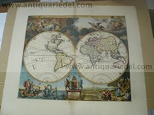
Hardcover. Zustand: very good. Orbis Terrarum Nova Et Accuratissima Tabula, 1680, Moses Pitt Orbis Terrarum Nova Et Accuratissima Tabula. Auctore Ioanne a Loon. Moses Pitt London / 1680 A fine example of Moses Pitt's double hemisphere map of the world. Pitt and his partner acquired the plates from Blaeu's Grand Atlas and set out… to issue and even larger Atlas in London. However, after 4 volumes, they landed in Debtor's prison and the atlas was never completed. The map offered here is based upon Visscher's World map of 1658 (Shirley 406) and Van Loon's rare Zee Atlas, first issued in 1661. Size of the sheet: 60 x 67 cm., printed area: 44 x 53 cm., the map is printed on thick paper, wide margins, only little brownish centerfold, fine hand coloured.
 Weitere Bilder
Verlag: Pitt Moses, 1639-1697, 1697
- Hardcover
Anbieter: Hammelburger Antiquariat, Hammelburg, DeutschlandHammelburger Antiquariat
Verkäufer/-in kontaktierenVerkäufer/-in mit 5 SternenZustand: Gebraucht - Gut
EUR 4.000,00
EUR 30,00 VersandVersand von Deutschland nach USAAnzahl: 1 verfügbar
Hardcover. Zustand: very good. A map of the NORTHPOLE and the parts adioining, 1680, Pitt Moses Attractive English map of the North Pole and Arctic regions. The map combines some out-dated cartography with a solid view of Hudson and Baffin bays. In Canada the unusual three-island configuration of northern Labrador is derived in…part from Sanson's map of 1656. Pitt includes the mythical island of Freesland complete with several place names and Forbishers Strait bisects the southern tip of Greenland. Cartographically the map is notable for the small inset map of Nova Zembla with an explanation that new information had arrived from Russia indicating that it was joined to the mainland instead of being an island as shown on the main map. The cartouche emphasizes the importance of whaling in the region with whaling scenes, walruses, narwhales and Eskimos in their kayaks. A magnificent coat of arms dedicates the map to Charles Fitz Charles, Earl of Plymouth. Size of the sheet: 58x67 cm., printed on thick paper, wide margins, only small tears on margins and only little fingerstained. This is the only original work prepared by Pitt for his ill-fated and uncompleted atlas. It was likely engraved by Michael Burghers, a Dutch emigrant who became the official engraver to the University of Oxford. The atlas was projected to be a 12 volume work in the tradition of the earlier Dutch atlases and was to use updated copperplates belonging to Johannes Jansson van Waesberge, son-in-law and heir of Jan Jansson. Only 4 volumes were completed before the venture failed and Pitt was thrown into debtor's prison.

Verlag: Pitt Moses, 1639-1697, 1697
- Hardcover
Anbieter: Hammelburger Antiquariat, Hammelburg, DeutschlandHammelburger Antiquariat
Verkäufer/-in kontaktierenVerkäufer/-in mit 5 SternenZustand: Gebraucht - Gut
EUR 800,00
EUR 30,00 VersandVersand von Deutschland nach USAAnzahl: 1 verfügbar
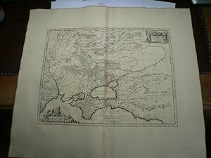
Hardcover. Zustand: very good. Moscoviae pars Australis, anno 1680, Pitt Moses, printed on thick paper, wide margins, centerfold little brownish. On eastern border the Wolga River, in the West Smolensk.

Verlag: Pitt Moses, 1639-1697, 1697
- Hardcover
Anbieter: Hammelburger Antiquariat, Hammelburg, DeutschlandHammelburger Antiquariat
Verkäufer/-in kontaktierenVerkäufer/-in mit 5 SternenZustand: Gebraucht - Gut
EUR 600,00
EUR 30,00 VersandVersand von Deutschland nach USAAnzahl: 1 verfügbar
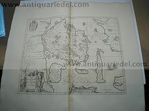
Hardcover. Zustand: very good. Prussia Accurate Descripta - J. Janssonius - Moses Pitt, 1680. Old map of Poland - Prussia by J. Janssonius, published by Moses Pitt & J. Janssonius-Waesberge Cartographer: Gaspar Henneberg Copper engraving Size: 38 x 49cm., printed area, 60x68 cm. sheet. Verso: Blank Printed on thick paper, wide m…argins, only little brownish centerfold.


