Gesamtpreis (1 Artikel Artikel):
Versandziel:

petermann augustus (21 Ergebnisse)
Direkt zu den wichtigsten Suchergebnissen
Suchfilter
Produktart
- Alle Product Types
- Bücher (15)
- Magazine & Zeitschriften (Keine weiteren Ergebnisse entsprechen dieser Verfeinerung)
- Comics (Keine weiteren Ergebnisse entsprechen dieser Verfeinerung)
- Noten (Keine weiteren Ergebnisse entsprechen dieser Verfeinerung)
- Kunst, Grafik & Poster (Keine weiteren Ergebnisse entsprechen dieser Verfeinerung)
- Fotografien (Keine weiteren Ergebnisse entsprechen dieser Verfeinerung)
- Karten (6)
- Manuskripte & Papierantiquitäten (Keine weiteren Ergebnisse entsprechen dieser Verfeinerung)
Zustand Mehr dazu
- Neu (6)
- Wie Neu, Sehr Gut oder Gut Bis Sehr Gut (Keine weiteren Ergebnisse entsprechen dieser Verfeinerung)
- Gut oder Befriedigend (12)
- Ausreichend oder Schlecht (Keine weiteren Ergebnisse entsprechen dieser Verfeinerung)
- Wie beschrieben (3)
Einband
Weitere Eigenschaften
- Erstausgabe (1)
- Signiert (Keine weiteren Ergebnisse entsprechen dieser Verfeinerung)
- Schutzumschlag (Keine weiteren Ergebnisse entsprechen dieser Verfeinerung)
- Angebotsfoto (13)
Sprache (2)
Gratisversand
- Kostenloser Versand nach USA (Keine weiteren Ergebnisse entsprechen dieser Verfeinerung)
Land des Verkäufers
Verkäuferbewertung
-

The Census of Great Britain in 1851: Comprising an Account of the Numbers and Distribution of the People, Their Ages, Conjugal Condition, Occupations, ... Deaf-and-dumb, and the Inmates of Public...
Anbieter: Ria Christie Collections, Uxbridge, Vereinigtes Königreich
Verkäuferbewertung 5 von 5 Sternen

EUR 22,89
EUR 13,99 Versand
Versand von Vereinigtes Königreich nach USAAnzahl: Mehr als 20 verfügbar
In den WarenkorbZustand: New. In.
-

The Census of Great Britain in 1851: Comprising an Account of the Numbers and Distribution of the People, Their Ages, Conjugal Condition, Occupations, ... Deaf-and-dumb, and the Inmates of Public...
Anbieter: Ria Christie Collections, Uxbridge, Vereinigtes Königreich
Verkäuferbewertung 5 von 5 Sternen
EUR 33,67
EUR 13,99 Versand
Versand von Vereinigtes Königreich nach USAAnzahl: Mehr als 20 verfügbar
In den WarenkorbZustand: New. In.
-
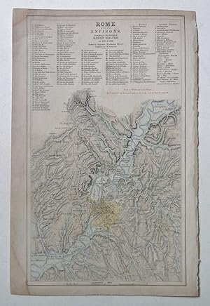
Rome with its Environs, from Surveys by Baron Moltke
Verlag: Swanston, UK, 1846
Anbieter: Maynard & Bradley, Leicester, Vereinigtes Königreich
Verkäuferbewertung 5 von 5 Sternen
EUR 19,19
EUR 25,63 Versand
Versand von Vereinigtes Königreich nach USAAnzahl: 1 verfügbar
In den WarenkorbSoftcover. Zustand: Very Good. Augustus Petermann (illustrator). 1846. A very well-preserved engraving by Swanston, from Petermann c.1846. Faintly hand-coloured and overall very presentable, with the print itself remaining cleana nd clear across the entire image surface. the page bears a light damp mark at lower corner and some wear along right edge from removal from binding, not encroaching significantly on the print itself, would be easily concealed by a mount. Why on Amazon do most sellers not describe their actual book? Buy with confidence and support a genuine Independent Bricks & Mortar Real Bookshop. We are Maynard & Bradley CAMBO & PBFA(now lapsed) members here in Leicester City Centre. Size: 180 x 250 mm. 1 pages. Item Type: Book. Illustrator: Augustus Petermann. Quantity Available: 1. Shipped Weight: Under 500 grams. Category: Geography & Maps; Britain/UK; 19th century; Pictures of this item not already displayed here available upon request. Inventory No: 11945.
-

EUR 27,92
EUR 48,99 Versand
Versand von Deutschland nach USAAnzahl: Mehr als 20 verfügbar
In den WarenkorbZustand: New.
-

EUR 39,46
EUR 48,99 Versand
Versand von Deutschland nach USAAnzahl: Mehr als 20 verfügbar
In den WarenkorbGebunden. Zustand: New.
-

The Census of Great Britain in 1851: Comprising an Account of the Numbers and Distribution of the People, Their Ages, Conjugal Condition, Occupations
Sprache: Englisch
Verlag: Creative Media Partners, LLC Sep 2021, 2021
ISBN 10: 1015330428 ISBN 13: 9781015330429
Anbieter: AHA-BUCH GmbH, Einbeck, Deutschland
Verkäuferbewertung 5 von 5 Sternen
Taschenbuch. Zustand: Neu. Neuware - This work has been selected by scholars as being culturally important and is part of the knowledge base of civilization as we know it.
-

The Census of Great Britain in 1851 : Comprising an Account of the Numbers and Distribution of the People, Their Ages, Conjugal Condition, Occupations, and Birthplace, With Returns of the Blind, the Deaf-and-dumb, and the Inmates of Public.
Sprache: Englisch
Verlag: Creative Media Partners, LLC Sep 2021, 2021
ISBN 10: 1013951263 ISBN 13: 9781013951268
Anbieter: AHA-BUCH GmbH, Einbeck, Deutschland
Verkäuferbewertung 5 von 5 Sternen
Buch. Zustand: Neu. Neuware - This work has been selected by scholars as being culturally important and is part of the knowledge base of civilization as we know it.This work is in the public domain in the United States of America, and possibly other nations. Within the United States, you may freely copy and distribute this work, as no entity (individual or corporate) has a copyright on the body of the work.Scholars believe, and we concur, that this work is important enough to be preserved, reproduced, and made generally available to the public. To ensure a quality reading experience, this work has been proofread and republished using a format that seamlessly blends the original graphical elements with text in an easy-to-read typeface.We appreciate your support of the preservation process, and thank you for being an important part of keeping this knowledge alive and relevant.
-

Australia: Süd-östliches Australien
Sprache: Englisch
Erscheinungsdatum: 1850
Anbieter: Hornseys, Ripon, Vereinigtes Königreich
Verbandsmitglied: PBFA
Verkäuferbewertung 5 von 5 Sternen
EUR 36,08
EUR 29,19 Versand
Versand von Vereinigtes Königreich nach USAAnzahl: 1 verfügbar
In den WarenkorbNo Binding. Zustand: Very Good. Date: 1850. Original steel engraving. Sheet size: 43.9cm x 35.2cm. Blank to the reverse. Contemporary outline hand-colouring. Highly detailed. Inset maps of West Australia and Tasmania. Minor age toning which is mainly confined to the margins with a very small amount of loss. A very good, bright, clean copy. Sleeve 1111: Map Drawer D.
-

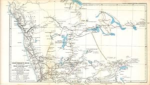
Peru and Bolivian Tablelands.
Verlag: London & Edinburgh: Arrowsmith & Co. c.1880, 1880
Anbieter: Peter Harrington. ABA/ ILAB., London, Vereinigtes Königreich
Verbandsmitglied: ABA ILAB PBFA
Verkäuferbewertung 5 von 5 Sternen
EUR 48,11
EUR 25,69 Versand
Versand von Vereinigtes Königreich nach USAAnzahl: 1 verfügbar
In den WarenkorbInteresting little map detailing the heights of the mountain ranges and heights in Peru and Bolivia. Lithograph with printed colour. Very good condition. Size: 25.5 x 16.5 cm.
-

Portions of the Russian Empire in Eastern & Western Asia (c.1850)
Verlag: Fullarton & Co., UK, 1850
Anbieter: Maynard & Bradley, Leicester, Vereinigtes Königreich
Verkäuferbewertung 5 von 5 Sternen
EUR 114,26
EUR 25,63 Versand
Versand von Vereinigtes Königreich nach USAAnzahl: 1 verfügbar
In den WarenkorbSoftcover. Zustand: Good. c.1850. Some wear around the outer edges has been carefully patched and repaired with conservation tape and sympathetically-coloured paper to prevent further tears and preserve the integrity of the title, but the printed content remains otherwise intact and well-presented with no major marks or signs of wear across the image surface. Why on Amazon do most sellers not describe their actual book? Buy with confidence and support a genuine Independent Bricks & Mortar Real Bookshop. We are Maynard & Bradley CAMBO & PBFA(now lapsed) members here in Leicester City Centre. Size: 470 x 320 mm. 1. Item Type: Book. Quantity Available: 1. Shipped Weight: Under 500 grams. Category: Geography & Maps; Britain/UK; Modern; Inventory No: 34910.
-

Thomas Elders' Expedition durch Inner-Australien vom Murchison im Westen, bis zum Neales im Osten, Ausgefuhrt Durch E. Giles, April-Aug. 1876
Verlag: Gotha, 1877
Anbieter: Antipodean Books, Maps & Prints, ABAA, Garrison, NY, USA
Verbandsmitglied: ABAA ANZAAB ESA ILAB
Verkäuferbewertung 4 von 5 Sternen

Zustand: Very good condition. The map illustrates Ernest Giles 2nd expedition across Australia. The explorer's routes marked include Warburton, April 15, 1873 to January 26, 1874; Giles: August 1873 to June 1874; Forrest: Apirl 22 to September 27, 1874. It shows Western Australia from Shark's Bay north to 80 Mile Beach, just beyond present site of Port Hedland and east to Mt. Browne in South Australia. The Petermann Ranges feature just into South Australia, named for the cartographer/publisher, Augustus Petermann. 26 x 10". Original printed and outline color. Sir Thomas Elder was a Scottish-Australian pastoralist, highly successful businessman, philanthropist, politician, race-horse owner and breeder, and public figure. Amongst many other things, he is notable for introducing camels to Australia. Elder encouraged exploration, contributed largely to Warburton's 1873 expedition and Giles's in 1875, supplying camels in each case, which proved to be of the greatest value. He also contributed liberally to the cost of other explorations, and in no case sought or obtained any return for himself. On one occasion he offered Ł5,000 on condition that a like sum was subscribed by the public to finance an expedition to the Southern Ocean, but the condition was not fulfilled. William Ernest Powell Giles (1835 - 1897) was an Australian explorer who led five major expeditions in central Australia. (1835-1897)). Giles was bornin 1835 at Bristol, England, son of William Giles, merchant, and his wife Jane Elizabeth, née Powell. Educated at Christ's Hospital (where he was admitted as William Ernest Powell Giles) he followed his parents to Adelaide in 1850. He moved to Victoria in 1852, tried his luck on the goldfields without success and became a post office clerk in Melbourne. By 1861 he was in western New South Wales where until 1865 he engaged in several expeditions aimed at assessing the pastoral country beyond the Darling River. These journeys gave him both the experience and the taste for further exploration. In 1872, Giles was chosen to lead a small expedition organized by Dr Mueller to investigate parts of central Australia west of the new overland telegraph line. From Charlotte Waters the party followed the Finke Valley to the Missionaries' Plain south of the MacDonnell Ranges, but found its way blocked to the west by lack of water and to the south by the salt-pans of Lake Amadeus which Giles named. There his second-in-command, Carmichael, insisted on turning back despite Giles's wish to find a route to the coast of Western Australia. This ambition was to inspire his remaining expeditions, the first of which, again backed by Mueller, was assembled next year. Starting further south Giles followed the line of the Musgrave Ranges which, unknown to him, had just been discovered by Gosse. On reaching Mount Olga which he had earlier named from a distance, Giles found from Gosse's dray tracks that he had been anticipated but since they soon turned back he was encouraged to persevere. He spent the next summer trying to break through to the west from a base in the Tomkinson Range and in autumn persisted in attacking the desert from a northerly point in the Rawlinson Range. A desperate final effort cost him the life of one of his men, who gave his name to Gibson's Desert, and brought Giles himself close to death; the exhaustion of his supplies compelled him to retreat, defeated, to the overland telegraph line. Although forestalled by P. E. Warburton and John Forrest, Giles succeeded in his cherished aim of making an overland crossing from South to Western Australia in 1875. Equipped with camels by Thomas Elder, he set out from Beltana and went for supplies to Port Augusta whence he proceeded first north-west and then west along a string of waterholes, Wynbring, Ooldea, Ooldabinna and Boundary Dam, until he reached the Western Australian border. He then risked a 312-mile (502 km) marathon across the Great Victoria Desert before discovering the Queen Victoria Springs; from there.
-
Mittheilungen aus Justus Perthes' Georgraphischer Anstalt Uber Wichtige Neue Erforschungen auf Dem Gesammtgebiete Der Geographie
Verlag: Justus Perthes 1855, Gotha, 1855
Anbieter: Foster Books - Stephen Foster - ABA, ILAB, & PBFA, London, Vereinigtes Königreich
Verbandsmitglied: ABA ILAB PBFA
Verkäuferbewertung 5 von 5 Sternen
EUR 150,34
EUR 14,60 Versand
Versand von Vereinigtes Königreich nach USAAnzahl: 1 verfügbar
In den WarenkorbCloth Spine. Zustand: Good. German language. vi, 378 pp. 23 lithographic maps, a couple of which are fold-out. Cloth spine with paper hand-written title labels over hard boards; corners covered in cloth. Wear and bumping to binding, including short patch of splitting to lower front joint, with binding being shaken. Foxing. Dr Augustus Petermann worked for a time in Edinburgh, at W. & A. K. Johnston, and then London, before moving to Gotha, where he wrote this important geographical work. 4to. Map.
-
The Atlas of Physical Geography. 1850
Verlag: S Orr & Co, London, 1850
Anbieter: Barter Books Ltd, Alnwick, NORTH, Vereinigtes Königreich
Verbandsmitglied: IOBA
Verkäuferbewertung 5 von 5 Sternen
Erstausgabe
EUR 176,80
EUR 9,34 Versand
Versand von Vereinigtes Königreich nach USAAnzahl: 1 verfügbar
In den WarenkorbBlack hardback cloth cover. Zustand: Good. First Edition. G: in good condition. Cover stained and partially faded. Shelf-wear. Chipping to spine ends, with some loss. Inner hinge cracking. Light browning to page edges. Sporadic foxing and marking. Some off-setting. 380mm x 290mm (15" x 11"). 142pp + plates. Colour frontispiece + 13 [of 13] maps (2 double-page) + b/w vignettes. Extra shipping may be needed for overseas destinations. Heavy item - shipping supplement may apply for overseas.
-
Hydrographical Map of the British Isles Exhibiting the Geographical Distribution of the Inland Waters, scale 25 miles to 1 inch
Verlag: Published by Edward Stanford, London, 1866
Anbieter: Keoghs Books, Skipton, Vereinigtes Königreich
Verbandsmitglied: PBFA
Verkäuferbewertung 5 von 5 Sternen
Karte
EUR 240,55
EUR 32,70 Versand
Versand von Vereinigtes Königreich nach USAAnzahl: 1 verfügbar
In den Warenkorb, linen backed map folded in 20 sections. Hand Coloured in outline. New Edition , close tears along joints of cover and an open tear at head of the spine, cover and title label faded, corners bumped, map is clean and in very good condition , map on linen folding into brown cloth cover, paper title label , 22 x 14 cm (folded), 85.5 x 63.5 cm (open) Map ISBN:
-
Western Australian Maps from Petermann's Geographical Journal published in "Mittheilungen aus Justus Perthes' Geographischer Anstalt," 9 maps from 1862-1881
Verlag: Augustus Petermann, Gotha, 1881
Anbieter: Antipodean Books, Maps & Prints, ABAA, Garrison, NY, USA
Verbandsmitglied: ABAA ANZAAB ESA ILAB
Verkäuferbewertung 4 von 5 Sternen
Zustand: Very good condition. A collection of nine maps of Australian exploration from Petermann's Journal, from 1862 to 1881. Augustus Petermann studied and worked with famous German and English cartographers in the 1840's, and eventually established his Geographical Journal in 1855, which is published to this day. Through his association with the Royal Geographical Society in London and later as the first head of the Geographical Institute in Gotha, he had extensive correspondence with a large number of explorers and travelers, who contributed the very latest information for the "Journal". His contacts from his R.G.S. days lead to many Australian explorations being reported in his "Journal" and nowhere else (eg. Lefroy 1864). The Petermann Ranges, in the west of South Australia, are named after him. Petermann's maps included much topographical and water system detail and were used to update such atlases as Stieler Hand Atlas. In 1869 Petermann encouraged the German push on the North Pole, organizing 2 expeditions. All maps are lithographs printed in color. [1862]. Provisorische Karte von Frank Gregory's reisen in Nordwest-Australien April bis June 1858 & Mai bis Oktober 1861. 9 3/4 x 8". WA from Sharks Bay to Cape Larry. (7) [1863]. Karte der Reise von C. & A. Dempster, Clarkson & Harper innern von West Australien Juli & August 1861. 17 x 10". From York to Lake Grace & Mt. Kennedy. Much detail of an expedition that was never published in English. (9) [1864]. Karte von H.M. Lefroy's Exploration innern von West-Australien Mai bis Juli 1863. 15 1/4 x 10". York to Mt. Robinson with Lake Moore in the top left corner. Never published in English. (10) [1869]. John Forrest's Reise im Innern von West-Australien April-Mai 1869. Nebst Ubersicht der Entdeckungen bis 1869. 17 x 10 1/2". Printed outline color. Perth to Murchison River inland to Hampton Plains and Lake Lefroy. Expedition routes include Forrest, AC Gregory, Dale, Austin, Roe, C & A Dempster, Moore, Lefroy & Robinson, F. Gregory, Hunt, Helpman. (20) [1874]. Vorlaufige Skizze von Gosse's & Warburton's Reisen durch West-Australien 1873-4 & Standpunkt der Geographischen Kenntniss dieses Gebietes in 1874. 10 1/2 x 13". Warburton's route from Perth to the overland telegraph, inset of Sydney. (24) [1874]. Thomas Elders' Expedition durch Inner-Australien von Beltana im Osten bis Perth im Western ausgefuhrt durch E. Giles Mai-Nov 1875. 26 x 10 1/2". SW Australia from Bunbury to Adelaide in the south, upper Murchison to north of Lake Eyre in the north. Very unusual projection, water and sea outlined in blue. (26) [1876]. Die Neuesten Entdeckung-reisen im Innern von Australien von Warburton Giles Forrest April 1873-Sept 74. 25 3/4 x 10". Sharks Bay to 90 Mile Beach over to Alice Springs. Much geographical detail on the inland exploration. (27) [1877]. Thomas Elders' Expedition durch Inner-Australien von Murchison im Westen, bis zum Neales im Osten, Ausgefuhrt durch E. Giles, April-Aug 1876. The map illustrates Ernest Giles 2nd expedition across Australia. The explorers' routes marked include Warburton, April 15, 1873 to January 26, 1874; Giles: August 1873 to June 1874; Forrest: April 22 to September 27, 1874. It shows Western Australia from Shark's Bay north to 80 Mile Beach, just beyond present site of Port Hedland and east to Mt. Browne in South Australia. The Petermann Ranges feature just into South Australia, named for the cartographer/publisher, Augustus Petermann. 26 x 10". [1881]. Nordwest-Australien und Timor Meer nach Alex Forrest's Forschungen 1879 und den Neuesten Nautischen Vemessumgen. 10 x 8". Outlines explorations by A. Forrest 1879; L. Leichhardt 1845; A. C. Gregory 1855-6; J. McD. Stuart 1862; J. McKinlay 1866; G. McMinn 1876; A. W. Sergison 1877; J. G. Brockman 1879-80. Map from south of Roebuck Bay -Coburg Peninsula. Towns and names in English, observations in German. (29).
-
Java
Verlag: A. Fullarton & Co c. 1860, London & Edinburgh, 1860
Anbieter: Alexandre Antique Prints, Maps & Books, Toronto, ON, Kanada
Verkäuferbewertung 4 von 5 Sternen
Karte
Zustand: Very Good; Along bottom margin is a sectional view of the topography, identifying highest peaks and cities., Size : 136x257 (mm), 5.35x10.12 (Inches), Hand Colored.
-
Principal Dutch Colonies, in the Indian Seas. / Java
Verlag: Fullarton, London, 1860
Anbieter: Alexandre Antique Prints, Maps & Books, Toronto, ON, Kanada
Verkäuferbewertung 4 von 5 Sternen
Karte
Zustand: Very Good; Corner vignettes depict wildlife and a native riding a bull, fending off a tiger that is trying to take the native's dead deer., Size : 174x311 (mm), 6.85x12.24 (Inches), Hand Colored.
-

Portions of the Russian Empire in Eastern and Western Asia. 1. The Aral Sea according to Khanikoff. 2. Kamchatka according to A. Erman Plate 8.
Verlag: London: The Royal Illustrated Atlas of Modern Geography, Fullarton & Co. [c.1850], 1850
Anbieter: Peter Harrington. ABA/ ILAB., London, Vereinigtes Königreich
Verbandsmitglied: ABA ILAB PBFA
Verkäuferbewertung 5 von 5 Sternen
EUR 240,55
EUR 25,69 Versand
Versand von Vereinigtes Königreich nach USAAnzahl: 1 verfügbar
In den WarenkorbTwo maps on one sheet: One showing the Aral Sea, and the other showing Kamchatka. There are three vignettes to the left depicting the Kirghiz people from near the Aral Sea, and three vignettes of Kamchatkan life to the right. Below the maps is a view of 'Petropaulovski', a port in Kamchatka. Steel engraving. Fine condition. Hand coloured. Size: 28 x 23.5 cm. (11 x 9˝ inches).
-
Dutch Possessions in South America and the West Indies / Curacao
Verlag: Fullarton, London, 1860
Anbieter: Alexandre Antique Prints, Maps & Books, Toronto, ON, Kanada
Verkäuferbewertung 4 von 5 Sternen
Karte
Zustand: Very Good; Size : 228x317 (mm), 8.98x12.48 (Inches), Hand Colored.
-
British Guayana
Verlag: A Fullarton & Co, London, Edinburgh & Dublin, 1860
Anbieter: Alexandre Antique Prints, Maps & Books, Toronto, ON, Kanada
Verkäuferbewertung 4 von 5 Sternen
Karte
Zustand: Very Good; Size : 293x315 (mm), 11.5x12.375 (Inches), Hand Colored.
-
Karte des Arktischen Archipel's der Parry Inseln
Verlag: Justus Perthes c.1855, Germany, 1855
Anbieter: Alexandre Antique Prints, Maps & Books, Toronto, ON, Kanada
Verkäuferbewertung 4 von 5 Sternen
Karte
Zustand: Very Good. A fine and scarce map of the Parry Islands during the mid 19th century. The map shows geographical features and areas that were first explored. The map has a small inset map of Erebus Bay and two inset views. , Size : 245x567 (mm), 9.65x22.32 (Inches), Hand Colored.