
Paris plan (23 Ergebnisse)

Le Paris du Xviie Sicle Plan Monumental de la Ville de Paris, Ddi Et Prsent au Roy Louis XIV 1653 Classic Reprint
Plan Monumental De La Ville De Paris, Dédié Et Présenté Au Roy Louis XIV (1653)
- Softcover
Anbieter: PBShop.store US, Wood Dale, IL, USAPBShop.store US
Verkäufer/-in kontaktierenVerkäufer/-in mit 5 SternenZustand: Neu
EUR 25,29
Versand nach gratisVersand innerhalb von USAAnzahl: 15 verfügbar
PAP. Zustand: New. New Book. Shipped from UK. Established seller since 2000.
Le Paris du Xviie Sicle Plan Monumental de la Ville de Paris, Ddi Et Prsent au Roy Louis XIV 1653 Classic Reprint
Plan Monumental De La Ville De Paris, Dédié Et Présenté Au Roy Louis XIV (1653)
- Softcover
Anbieter: PBShop.store UK, Fairford, GLOS, Vereinigtes KönigreichPBShop.store UK
Verkäufer/-in kontaktierenVerkäufer/-in mit 5 SternenZustand: Neu
EUR 25,10
EUR 3,87 VersandVersand von Vereinigtes Königreich nach USAAnzahl: 15 verfügbar
PAP. Zustand: New. New Book. Shipped from UK. Established seller since 2000.

Verlag: Editions A. Lecomte.
- Hardcover
Anbieter: Loïc Simon, Blaison-Saint Sulpice, FR, FrankreichLoïc Simon
Verkäufer/-in kontaktierenVerkäufer/-in mit 5 SternenZustand: Gebraucht
EUR 18,00
EUR 19,00 VersandVersand von Frankreich nach USAAnzahl: 1 verfügbar
In den WarenkorbPlan dépliant hors texte. Sans date. Cartonné. 160 pages.
Verlag: Garnier, sd (ca 1890), 1890
- Hardcover
Anbieter: Librairie de l'Avenue - Henri Veyrier, Saint-Ouen, FR, FrankreichLibrairie de l'Avenue - Henri Veyrier
Verkäufer/-in kontaktierenVerkäufer/-in mit 5 SternenZustand: Gebraucht - Gut bis sehr gut
EUR 59,00
EUR 35,00 VersandVersand von Frankreich nach USAAnzahl: 1 verfügbar
In den WarenkorbCouverture rigide. Zustand: Bon état. In-12 percaline rouge de l'éditeur aux armes dorées, ornements noirs. Contient un Plan replié en couleurs de Paris dressé par A. Vuillemin, ainsi qu'un Dictionnaire Général des Rues de Paris. Bon exemplaire. in-12°.

Verlag: O.O. u. Dr., um 1870., 1870
- Hardcover
Anbieter: Antiquariat MEINDL & SULZMANN OG, Wien - Vienna, ÖsterreichAntiquariat MEINDL & SULZMANN OG
Verkäufer/-in kontaktierenVerkäufer/-in mit 5 SternenZustand: Gebraucht
EUR 60,00
EUR 35,00 VersandVersand von Österreich nach USAAnzahl: 1 verfügbar
In den WarenkorbIn 15 Segmenten auf Leinen aufgezogen und faltbar eingerichtet. Blattgröße ca. 70 x 85 cm. Bildausschnitt ca. 50 x 64,5 cm. (nur gering fleckig). Der seltene Plan zeigt auch, markiert mit "a", die "reservirten Räume für Militairetablissements" und mit "b" bie "beibehaltenen Erdwerke von 1832".- Links unter separat ein Plan des "…Forteresse du Mont Valérien" (ein fünfeckiges Fort, das zwischen 1840 und 1846 erbaut wurde. Es ist eines von sechzehn Forts, die rund um Paris errichtet wurden).

Verlag: Maison Logerot, J Gaultier, 1887
- Hardcover
Anbieter: LIBRAIRIE GIL-ARTGIL SARL, RODEZ, FrankreichLIBRAIRIE GIL-ARTGIL SARL
Verkäufer/-in kontaktierenVerkäufer/-in mit 4 SternenZustand: Gebraucht
EUR 200,00
EUR 37,00 VersandVersand von Frankreich nach USAAnzahl: 1 verfügbar
In den WarenkorbMaison Logerot, J Gaultier, 1887. Grande carte dépliante entoilée sous couverture de toile rouge de 85*63cm, divisé en 32 carré. Le cartonnage est abimé e décoloré. Carte en couleurs en très bon état.

Verlag: Paris, Lamour for A. Bernard, 1865., 1865
- Hardcover
Anbieter: Antiquariat INLIBRIS Gilhofer Nfg. GmbH, Vienna, A, ÖsterreichAntiquariat INLIBRIS Gilhofer Nfg. GmbH
Verkäufer/-in kontaktierenVerkäufer/-in mit 5 SternenZustand: Gebraucht
EUR 350,00
EUR 30,00 VersandVersand von Österreich nach USAAnzahl: 1 verfügbar
In den WarenkorbSmall 8vo. Lithographed folding plan of Paris in original hand-colour. Several wood-engraved views of landmarks. Contemporary marbled boards with red title label. A pocket-sized plan of Paris and its 20 districts, each coloured separately in four colours, showing the capital in the midst of Haussmann's radical renovation. Includ…es railway lines leading into the city and the surrounding forts, as well as illustrations of important landmarks, including the Louvre, the Palais du Luxembourg, Notre Dame, the Château de Vincennes and Père Lachaise. Also provides indices of street names and their positions on the map in the left and right margins. - Some signs of use, small tears in the top and bottom margins, extremeties a little rubbed. From the library of the Viennese collector Werner Habel, with his signed and stamped ownership, dated 1982, to front pastedown.

Anbieter: Celler Versandantiquariat, Eicklingen, DeutschlandCeller Versandantiquariat
Verkäufer/-in kontaktierenVerkäufer/-in mit 5 SternenVerbandsmitglied: GIAQ
Zustand: Gebraucht
EUR 30,00
EUR 38,00 VersandVersand von Deutschland nach USAAnzahl: 1 verfügbar
In den WarenkorbCharaire, Seaux, (1925). Mehrfach gefaltete Karte in kartoniertem Einband--- - viersprachig: französisch/englisch/italienisch/deutsch - 750 Gramm.

Sprache: Englisch
Anbieter: Sell Books, Elland, YORKS, Vereinigtes KönigreichSell Books
Verkäufer/-in kontaktierenVerkäufer/-in mit 5 SternenZustand: Gebraucht - Ausreichend
EUR 1.076,13
EUR 14,30 VersandVersand von Vereinigtes Königreich nach USAAnzahl: 1 verfügbar
unknown_binding. Zustand: Acceptable. Please see the condition note after this for details, if this is missing please consider Acceptable to mean poor quality that could include major staining, water damage, writing, missing dustjacket, etc etc. Our books are dispatched from a Yorkshire former cotton mill. We list via barcode/IS…BN so please note that the images are stock images and may not be the exact copy you receive, furthermore the details about edition and year might not be accurate as many publishers reuse the same ISBN for multiple editions and as we simply scan a barcode or enter an ISBN we do not check the validity of the edition data when listing. If you're looking for an exact edition please don't order (at least not without checking with us first, although we don't always have time to check). We aim to dispatch prompty, the service used will depend on order value and book size. We can ship to most countries, see our shipping policies. Payment is via Abe only.
Sprache: Französisch
Verlag: chés Lattré, rue St Jacques, à la Ville de Bordeaux, 1772
Anbieter: Librairie Rouchaleou, Saint-André-de-Sangonis, FR, FrankreichLibrairie Rouchaleou
Verkäufer/-in kontaktierenVerkäufer/-in mit 5 SternenZustand: Gebraucht - Sehr gut
EUR 1.200,00
EUR 54,00 VersandVersand von Frankreich nach USAAnzahl: 1 verfügbar
In den WarenkorbPas de couverture. Zustand: Très bon. 1 carte gravée entoilée pliée du XVIIIème siècle, dépliante de format 55 x 77 cms (toile saumon de l'époque), repliée au format in 8, en 24 feuillets gravés, avec une table alphabétique des rues, paroisses, collèges, hôpitaux, communautés, hospitaliers, 4 auréoles claires au niveau du bas de… la carte. Carte ornée d'un beau cartouche de titre illustré au blason de la ville de Paris, et finement rehaussé à l'aquarelle à l'époque (scarce map of 18th century, finely colored). Rare '' Carte routière de ville et faubourg de Paris '', carte gravée imprimée sur beau vergé, avec cartouche et contours finement coloriés à l'époque. Jean Lattre. Bel exemplaire.
Verlag: Editions Les Yeux Ouverts. 1966., 1966
Anbieter: Loïc Simon, Blaison-Saint Sulpice, FR, FrankreichLoïc Simon
Verkäufer/-in kontaktierenVerkäufer/-in mit 5 SternenZustand: Gebraucht
EUR 210,00
EUR 19,00 VersandVersand von Frankreich nach USAAnzahl: 1 verfügbar
In den WarenkorbLe plus beau plan de Paris à vol d'oiseau. Notice d'André Rossel. Maquette et couverture de F. Doat. 20 planches et 20 feuilles de descriptions et notices. Couverture défraichie.

Verlag: Mondhare and Jean, Paris, 1789
- Karte
Anbieter: Arader Books, New York, NY, USAArader Books
Verkäufer/-in kontaktierenVerkäufer/-in mit 5 SternenZustand: Gebraucht - Gut
EUR 1.218,06
Versand nach gratisVersand innerhalb von USAAnzahl: 1 verfügbar
In den WarenkorbNo binding. Zustand: Very good. PARIS ON THE EVE OF THE REVOLUTION. Paris: Mondhare and Jean, 1789. Folding engraved map (24 3/4" x 38 3/8", 629mm x 975mm) dissected and mounted on cartographic linen in 24 segments. The title within an allegorical cartouche top left, an inset of the "Banlieue de Paris" (Paris and surrounding sub…urbs) and an index to streets, parishes, churches, hospitals and libraries down the right and left sides Some wear at the folds of the linen, strengthened verso. Tanning to the edges of the segments. The odd spot of ink, with some damp-spotting. Printed in Paris in the months before the Revolution, the map gives no hint of the turmoil that would soon come to its peaceful and well-ordered streets, save the ominous "Nouvelle Enceinte des Barrieres," the system of barricades put in place to control crowds. Thus the final pre-Revolutionary place names are captured on this 1789 map, among them "Place de Louis XV," the site of the execution of Louis XVI and Marie Antionette, changed in 1795 to "Place de la Concorde" in celebration of the reconciliation following the revolution. The Hôtel des Invalides is here the "Hotel Royal des Invalides." The prison of Bastille looms intact. In the following year, the Assemblée nationale ordered Louis-Joseph Mondhare (1734-1799) and Pierre Jean (1754-1829) to issue a revised version of the map; the inset of the "Banlieue de Paris" to be replaced with a list of the 48 Sections into which Paris was divided under Revolutionary mandate.
Anbieter: Jürgen Patzer, Konstanz, DeutschlandJürgen Patzer
Verkäufer/-in kontaktierenVerkäufer/-in mit 4 SternenZustand: Gebraucht
EUR 85,00
EUR 19,00 VersandVersand von Deutschland nach USAAnzahl: 1 verfügbar
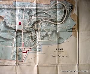
In den WarenkorbSehr gut erhaltener Plan des berühmten, 1804 auf dem Gelände der Gärten des Paters François d'Aix de Lachaise eingerichteten Friedhofs. Der Plan zeigt die gesamte Anlage und vermerkt die Gräber bedeutender Persönlichkeiten. - Papier leicht gebräunt. Handschriftlicher Eintrag auf der Rückseite des Plans (Bleistift) u. unterhalb d…er kleinen Ansicht (Buntstift).

- Karte
Anbieter: Geographicus Rare Antique Maps, Brooklyn, NY, USAGeographicus Rare Antique Maps
Verkäufer/-in kontaktierenVerkäufer/-in mit 4 SternenZustand: Gebraucht
EUR 505,27
EUR 14,89 VersandVersand innerhalb von USAAnzahl: 1 verfügbar
In den WarenkorbVery good. Exhibits wear and light toning along original fold lines. Minor verso reinforcement at a few fold intersections and on margins. Size 25.5 x 34.5 Inches. This 1855 Lallemand city plan or map of Paris, France combines charming pictorial views and the functionality of a city plan to create an incredible artifact. The Arc… de Triomphe, the Place de la Concorde, the Louvre, and Notre Dame are among the world-famous sites illustrated in profile. The Champ de Mars, which would host the Eiffel Tower thirty-four years later, is filled with trees and Parisians gallivanting on walks or horseback. The city's gardens are appear in detail, presenting the layout of the Jardin des Tuileries, the Jardin du Luxembourg, and the Jardin des Plantes. Paris's twelve arrondissements are shaded to allow for easy differentiation, in stark contrast to the uncolored suburbs circling the city. Two lovely views are situated along the bottom of the map. The first illustrates from the Tuileries Gardens toward the Arc de Triomphe and the second overlooks the Seine River from Pont Neuf. Lallemand's New Method Departing from conventional cartographic conventions, Lallemand overlays a system of numbered grid squares instead of a utilizing numbered columns and alphabetized rows. Then, he includes an alphabetized street and square index on the upper right and lower left that provides the numbered square for each. Since only major roads are illustrated and labeled, the index allows the viewer to easily locate any street in Paris. Publication History and Census This map was created and published by Lallemand in 1855. The OCLC catalogs this map as being present in over a dozen institutional collections worldwide. References: OCLC 18178614.

- Karte
Anbieter: Geographicus Rare Antique Maps, Brooklyn, NY, USAGeographicus Rare Antique Maps
Verkäufer/-in kontaktierenVerkäufer/-in mit 4 SternenZustand: Gebraucht
EUR 606,32
EUR 14,89 VersandVersand innerhalb von USAAnzahl: 1 verfügbar
In den WarenkorbVery good. Dissected and mounted on linen in twenty-one (21) panels. Slight loss to linen at a few fold intersections. Size 18 x 24.5 Inches. This is Auguste Logerot's 1852 pictorial city plan or map of Paris, published on the eve of the Haussmann Renovations. Pictorial illustrations highlight monuments, landmarks, and other imp…ortant buildings, including the Palais du Louvre, Notre Dame de Paris, the Palais du Luxembourg, the Arc de Triomphe, and the Hotel des Invalides. Paris's celebrated gardens, including the Tuileries, the Champ de Mars, and the Jardin des Plantes are illustrated and labeled. Hand coloring highlights the city's twelve arrondissements. A street index occupies the left and right borders. Haussmannization or the 'Grands Travaux' This map was published just before the 'Grand Traveaux', the transformation of Paris by Emperor Napoléon III and Baron Georges-Eugène Haussmann, began. Completed between 1853 and 1870, the renovation of Paris consisted of the demolition of medieval neighborhoods that were deemed overcrowded and unhealthy; the building of wide avenues; new parks and squares; the annexation of the suburbs surrounding Paris; and the construction of new sewers, fountains, and aqueducts. Known in French as the 'Grands Travaux,' Haussmann's redesign of Paris defined it as a modern city, with narrow alleyways and confusing streets replaced by a broad network of grand boulevards, imposing facades, parks, and monuments. Some of the more famous parts of Paris today, including the famous design of Étoile , where the Arc de Triomphe is located, were constructed during Haussmann's tenure as Prefect. Publication History and Census This map was created by Auguste Logerot, and engraved by Charles Dyonnet. The monuments were drawn by Thénot and engraved by Duchez. The map was published by Logerot in 1852. We note a single cataloged example, at the Bibliothèque nationale de France. References: OCLC 887563212.

- Karte
Anbieter: Geographicus Rare Antique Maps, Brooklyn, NY, USAGeographicus Rare Antique Maps
Verkäufer/-in kontaktierenVerkäufer/-in mit 4 SternenZustand: Gebraucht
EUR 8.084,28
EUR 14,89 VersandVersand innerhalb von USAAnzahl: 1 verfügbar
In den WarenkorbFair. Closed tear extending 5 inches into printed area from left margin repaired on verso. Two areas of loss in upper left quadrant not effecting printed area of image. Scuffing. Size 21.5 x 13.25 Inches. This is a rare 1790 Pierre-François Palloy broadside map of the Bastille published as part of Palloy's brilliant contemporane…ous merchandising of the French Revolution. Palloy recognized the significance of the Bastille as a symbol of the French Revolution. With the inspired idea that he would sell off the Bastille block by block, Palloy began demolishing the infamous prison on the night of its Storming. His entrepreneurship and promotional efforts not only made him rich, they also effectively cemented the Storming of the Bastille in the global imagination. The printed ephemera Palloy published to promote his demolition of the rebranding of the Bastille is thus of the utmost significance and rarity - this being just one of just 6 confirmed surviving examples. Palloy and the Bastille On the night of July 14, 1789, as the mob that stormed the Bastille moved on, the enterprising Palloy sent workers to the still-smoldering Bastille to begin demolition. Two days later, on the 16th, city electors formally awarded him the demolition contract. With nearly 1,000 workers on site daily for the subsequent 2 years, Palloy took apart the infamous prison block by block. Parisian society flocked to observe the historic work; among them, influential figures such as Honoré Gabriel Riqueti, Count of Mirabeau and Pierre Beaumarchais. Calling himself 'Palloy Patriote', he hosted grand balls on the prison's ruins, capitalizing on the public interest. Palloy let nothing go to waste - the stones, chains, and other parts of the prison were sold or given as souvenirs to government officials and the public. Among the items created were scale models of the Bastille (one of which he sent to each of the 83 newly created French Departments), medallions, dominoes, and card games. He even commissioned busts of Mirabeau and Rousseau carved from the Bastille's stonework. It has been estimated that Palloy produced some 25,000 medallions from the melted-down ironwork. Palloy's propagandistic promotion not only earned him a fortune, it cemented the Storming of the Bastille as a fundamental symbol of the French Revolution. A Closer Look The Bastille's 8 imposing towers dominate the image, each numerically indexed in the bottom corners. Over 36 locations are identified, with multiple shops, stables, and other locations keyed to the same number. Other identified locations include the library, the chapel, two drawbridges, the kitchens, and the governor's quarters. A short history of the Bastille written by Palloy occupies the space between the indexes. The Bastille The Bastille (officially known as the Bastille Saint-Antoine) was constructed between 1357 and 1380, during the Hundred Years' War (1337 - 1453), as a fortress to protect Paris's eastern approaches. It was an innovative design, with 8 towers overlooking Porte Saint-Antoine. Later, the fortress played a prominent role in French domestic conflicts, including the 15th-century Armagnac-Burgundian Civil War and the 16th-century Wars of Religion. The Bastille became a state prison in 1417, initially for nobility, but from 1659 as a general prison. 5,279 prisoners had been imprisoned in the Bastille by 1789. During the 18th century, the infamy of the Bastille grew as it became synonymous with oppressive government enforcement of political dissent. The Storming of the Bastille The Storming of the Bastille took place on July 14, 1789 (Bastille Day) at the outset of the French Revolution (1789 - 1799). After weeks of turmoil, tensions in Paris built toward a general riot, which the monarchy moved to put down. Parisians stormed the Hôtel des Invalides to capture the roughly 30,000 muskets stockpiled there. The mob discovered that the gunpowder had been moved to the Bastille for safer storage earlier that week. Thi.

- Karte
Anbieter: Geographicus Rare Antique Maps, Brooklyn, NY, USAGeographicus Rare Antique Maps
Verkäufer/-in kontaktierenVerkäufer/-in mit 4 SternenZustand: Gebraucht
EUR 1.768,44
EUR 14,89 VersandVersand innerhalb von USAAnzahl: 1 verfügbar
In den WarenkorbExcellent. Dissected and mounted on linen in 36 panels. Dimensions are the entire object not just the printed image. Size 34 x 52 Inches. This is a stunning 1856 Longuet city plan or map of Paris, France, during the reign of Napoleon III and the Second French Empire. The map illustrates the early stages of the Georges-Eugène Hau…ssmann Renovations of Paris, which took place from 1853 - 1870. A Closer Look With the Louvre near the center, the map depicts Paris and its environs from St. Cloud and Sèvres in the west to Vincennes (and the Bois de Vincennes) in the east and from Aubervilliers and St. Ouen in the north to Arcueil and Vitry in the south. Paris' fortifications, known as the Thiers Wall (discussed below), are highlighted in green, and all 94 bastions are numbered. Inside the city walls, Paris' 12 arrondissements are numbered. (The expansion to 20 arrondissements did not happen until 1859.) Important buildings and monuments are shaded a darker purple than the rest of the city and identified. Among these are the Louvre, the Palais des Tuileries, the École Militare, the Champ de Mars, the Champs Élysées, the Arc de Triomphe, and the Madeleine. Hospitals, factories, docks, prisons, markets, and schools are labeled as well. The Jardin des Tuileries, the Jardin du Luxembourg, and the Jardin des Plantes all stand out in green. Rail lines are orange. The Fortification of Paris Shocked by the seizure of Paris by foreign enemies during the 1814 Battle of Paris, the French King Louis-Philippe (1830 - 48), commissioned a network of walls and forts he believed would make Paris impregnable. The project was met with immediate opposition, some of which claimed that the walls were not defensive but intended to control Parisians in the event of an anti-monarchal rebellion. Nonetheless, under a plan prepared by Marshal General Jean-de-Dieu Soult (1759 - 1861), construction began in 1841. The completed fortifications, named the Thiers Wall after the French Prime Minister Adolphe Theirs (1797 - 1877), were, at enormous expense, completed in 1844. The walls were 33 kilometers long and consisted of 94 bastions, 17 gates, 23 minor road crossings, and 8 railroad gates. By 1919, advancements in military technology made the walls obsolete, leading them to be fully deconstructed by 1929 and replaced with the Boulevard Périphérique. Publication History and Census This map was published by Longuet (the successor to Simonneau) in Paris in 1856. We note a single cataloged example of the 1856 Longuet edition, which is part of the collection at the Bibliothèque nationale de France. Eugène Andriveau-Goujon began publishing editions of this exact map as early as 1844 and continued publishing editions through at least 1855. (Examples of the 1844 and 1847 Andriveau-Goujon editions are part of the collection at the BnF.) Languet began publishing editions of this map as early as 1847. References: OCLC 494635592.

Paris, tel qu'il est aujourd'hui.
1900 Joly City Plan or Map of Paris, France: 1900 Exposition Universelle
- Karte
Anbieter: Geographicus Rare Antique Maps, Brooklyn, NY, USAGeographicus Rare Antique Maps
Verkäufer/-in kontaktierenVerkäufer/-in mit 4 SternenZustand: Gebraucht
EUR 656,85
EUR 14,89 VersandVersand innerhalb von USAAnzahl: 1 verfügbar
In den WarenkorbGood. Wear and toning along original fold lines. Verso repairs to fold separations. Soiling on verso not evident on recto. Some damage where previously attached to binder along left border. Size 23.5 x 32.25 Inches. This is a 1900 L. Joly city plan or map of Paris highlighting the 1900 Exposition Universelle. The Exposition bega…n a new global era of technological innovation and social change. A Closer Look Beginning with the Exposition Universelle, the Château d'eau and the Salle des Fêtes are prominently illustrated on the Champ de Mars opposite the Eiffel Tower. Across the Seine, the Palais du Trocadéro appears. From there, the Exposition's pavilions extend along the Seine to the Pont Alexandre III. The pavilions dedicated to the participating nations line the left bank, while the 'Vieux Paris' attraction and other pavilions occupy the right bank. The Grand Palais and Petit Palais appear on the right bank between the Pont Alexandre III and the Champs-Elysées. Other pavilions occupy the Esplanade des Invalides. This map highlights Paris's other iconic monuments as well: the Louvre, the Arce de Triomphe, the Palais Royale, Notre Dame, and the Opera are all labeled. Famous parks, including the Jardin des Tuileries, the Jardin du Luxembourg, the Jardin des Plantes, and the Parc des Buttes Chaumont are all shaded green. At this time, Paris was surrounded by the massive Thiers Wall and its atendent fortifications. An inset in the upper left expands coverage to the Paris environs. In the upper right, a second inset details the French railroad network. Three views line the bottom border, from left: Notre Dame and the Seine, a general view of the city, and some of the Exposition buildings. 1900 Exposition UNierselle he 1900 Exposition Universelle, held in Paris, was a grand showcase of the achievements of the 19th century and a celebration of the dawn of a new era. Spanning from April to November, this world's fair highlighted the technological innovations, artistic accomplishments, and cultural diversity of the participating nations. Among its many attractions were the debut of the Grande Roue de Paris (a giant Ferris wheel), the first-ever moving sidewalk, and the stunning Petit and Grand Palais, which hosted exhibitions of fine arts and industrial advancements. Drawing over 50 million visitors, the Exposition Universelle left an indelible mark on the early 20th century, symbolizing hope, innovation, and international collaboration. Publication History and Census This map was edited and published by L. Joly in 1900. This is the only verifiable example of the present edition. A map published in 1900 by L. Joly is part of the collection at the Bibliothèque historique de la Ville de Paris, but it has not yet been digitized, and we have not been able to confirm whether it is the same edition. We believe the scales differ between the present example and the one held by the Bibliothèque historique de la Ville de Paris.
 Weitere Bilder
- Signiert
- Karte
Anbieter: Geographicus Rare Antique Maps, Brooklyn, NY, USAGeographicus Rare Antique Maps
Verkäufer/-in kontaktierenVerkäufer/-in mit 4 SternenZustand: Gebraucht
EUR 960,01
EUR 14,89 VersandVersand innerhalb von USAAnzahl: 1 verfügbar
In den WarenkorbGood. Dissected and mounted on linen in 32 panels. Old tape residue on verso. Areas of scuffing to corners and in top and bottom edges in printed title and copyright. Size 29.25 x 39.5 Inches. This is a c. 1942 Editions Blondel la Rougery city plan or map of Paris, France. The map illustrates Paris during the World War II (1939…- 1945) Nazi occupation. The name on the back, Capt. Franklin G. Fischrist (or possibly Tischrist), suggests it was used by an English or American officer after the war. A Closer Look Depicting Paris from the Seine east to the Chateau de Vincennes and from St. Ouen south to Gentilly, Ivry, and Montrouge, buildings throughout Paris are illustrated and shaded orange. These structures range from monuments such as the Eiffel Tower, the Arc de Triomphe, Notre Dame, and the Louvre to train stations, hospitals, and schools. The Jardin des Tuileries, the Jardin du Luxembourg, the Jardin des Plantes, the Parc des Buttes Chaumont, the Bois de Boulogne, and the Bois de Vincennes appear as open green spaces. Streets, roads, and alleys are labeled. The Paris Métro appears as bold blue lines, with blue text and numbers marking each stop. We have dated this map using the Paris Métro based on the extent of construction. An Unknown Provenance On the verso, Captain Franklin G. Tischrist (sp?) signed just above the Editions Blondel la Rougery bookplate. Unfortunately, we have been unable to trace this Captain, making it impossible to know his story. Publication History and Census This map was published between July 1939, when Métro Line 10 was extended to the Gare d'Austerlitz (not explicitly labeled here, but the extension is printed) and October 1942, when Métro Line 8 was extended from Porte de Charenton to Charenton-Écoles, which appears here as a dashed line indicating that it remains under construction. We have been unable to locate any other verifiable examples of the present edition. Blondel la Rougery published numerous editions of this map beginning as early as 1916 using the same title, making differentiating challenging. Nonetheless, we note an example of the 1944 edition with the Line 8 extension illustrated as a solid blue line at the Bibliothèque nationale de France. Signed by Author(s).

- Karte
Anbieter: Geographicus Rare Antique Maps, Brooklyn, NY, USAGeographicus Rare Antique Maps
Verkäufer/-in kontaktierenVerkäufer/-in mit 4 SternenZustand: Gebraucht
EUR 3.031,61
EUR 14,89 VersandVersand innerhalb von USAAnzahl: 1 verfügbar
In den WarenkorbVery good. Dissected and mounted on original linen. Foxing. Light scuffing to bottom border. Size 39 x 55 Inches. This is an impressive 1873 Victor Clérot city plan or map of Paris, measuring nearly 5 feet wide. In 1873, Paris was in the midst of recovery and transformation, still bearing the scars of the Franco-Prussian War and… the Commune of 1871. The Third Republic was consolidating its power, establishing a more stable and democratic government, setting the stage for Paris's resurgence as a center of cultural and intellectual activity in Europe. It also illustrates the Theirs Wall and the city's impressive, if short-lived, fortifications. A Closer Look Depicting Paris and its immediate suburbs, streets throughout the region are illustrated and labeled. Monuments within Paris appear, including the Opera, Notre Dame, the Louvre, and the Arc de Triomphe. Paris's city walls are highlighted in red, as are the short-lived ring forts. Outside the walls, both the Bois de Boulogne and the Bois de Vincennes appear in detail. Rail lines run into and out of Paris. The Fortification of Paris Shocked by the seizure of Paris by foreign enemies during the 1814 Battle of Paris, the French King at the time, Louis-Philippe (1830 - 1848), conceived of a broad network of walls and forts he believed would make Paris impregnable. The project was met with immediate opposition, some of which claimed that the walls were not defensive but intended to control Parisians in the event of an anti-monarchal rebellion. Nonetheless, under a plan prepared by Marshal General Jean-de-Dieu Soult (1759 - 1861), construction began in 1841. The completed fortifications, named the Thiers Wall after the French Prime Minister at the time, Adolphe Theirs (1797 - 1877), were, at enormous expense, completed in 1844. The walls were thirty-three kilometers long and consisted of ninety-four bastions, seventeen gates, twenty-three minor road crossings, and eight railroad gates. By 1919, advancements in military technology made the walls obsolete, leading them to be fully deconstructed by 1929 and replaced with the Boulevard Périphérique. Publication History and Census This map was drawn and published by Victor Clérot, engraved by Alexandre Martin, and printed by the Imprimerie Hermet in 1873. This is the only known surviving example of the present edition. Clérot published additional editions of the present map in 1870 and 1877.

- Karte
Anbieter: Geographicus Rare Antique Maps, Brooklyn, NY, USAGeographicus Rare Antique Maps
Verkäufer/-in kontaktierenVerkäufer/-in mit 4 SternenZustand: Gebraucht
EUR 1.010,54
EUR 14,89 VersandVersand innerhalb von USAAnzahl: 1 verfügbar
In den WarenkorbVery good. Dissected and mounted on linen in thirty-six (36) panels. Light wear along original linen fold lines. Size 30.125 x 45 Inches. This is a c. 1840 G. Alvar Toussaint city plan or map of Paris, France, under King Louis-Philippe (1830 - 1848). The map captures Paris when it remained a rabbit warren of narrow mediaeval str…eets - the Haussmannn Renovations did not begin until 1848. At the time Paris was the beating heart of European Romanticism, the home of Balzac, Delacroix, Rossini, Chopain, Liszt, Berlioz, Manet, Hugo, and so many others. A Closer Look Monuments, hospitals, museums, and other buildings (including a slaughterhouse) appear in black, including the Louvre and the Palais des Tuileries , the Arc de Triomphe , the Palais du Luxembourg , Les Invalides , and the École Militaire . Trees line the Champ de Mars , the Champs Élysées , and other avenues, parks, and boulevards. An alphabetic index occupies both the left and right, with references associated with a grid. A beautiful view stretching from Pont Neuf to the Pont des Saints Pères occupies the lower border. Publication History and Census This map was drawn by G. Alvar Toussaint, engraved by Frédéric-Guillaume Laguillermie and Lebel, with letter engraving by Abel Malo, and published by Binet c. 1840. We note three cataloged examples in OCLC: Princeton University, the Getty Research Institute, and the Bibliothèque nationale de France. References: Vallée, L. Catalogue des plans de Paris., 3051. OCLC 912450636.

- Karte
Anbieter: Geographicus Rare Antique Maps, Brooklyn, NY, USAGeographicus Rare Antique Maps
Verkäufer/-in kontaktierenVerkäufer/-in mit 4 SternenZustand: Gebraucht
EUR 960,01
EUR 14,89 VersandVersand innerhalb von USAAnzahl: 1 verfügbar
In den WarenkorbVery good. Dissected and mounted on linen in thirty-six (36) panels. Light toning along linen fold lines. Light soiling. Slight loss to linen at fold intersections. Size 30.25 x 43.75 Inches. This is a strikingly decorative 1849 Charles Dyonnet city plan or map of Paris, France. Published during the first year of the French Seco…nd Republic (1848 - 1852), the map details Paris, highlighting its buildings, parks, avenues, and other sites. Among these are the Jardin des Tuileries, the Champs- Élysées, the Louvre, the Palais du Luxembourg, the Jardin du Luxembourg, and Père Lachaise Cemetery. Streets and avenues are illustrated and labeled throughout. Train stations are illustrated, and rail lines are highlighted. Paris is surrounded by the recently completed Thiers Wall with its 94 bastions numerically identified. An alphabetic street index appears to the left and right, while an index of theaters, town halls, libraries, and museums occupies the upper right. The whole is surrounded by a arresting acanthus border. The Fortification of Paris This map illustrates the Theirs Wall five years after it was completed in 1844. Shocked by the seizure of Paris by foreign enemies during the 1814 Battle of Paris, the French King Louis-Philippe (1830 - 1848), conceived of a broad network of walls and forts he believed would make Paris impregnable. The project was met with immediate opposition, some of which claimed that the walls were not defensive but intended to control Parisians in the event of an anti-monarchal rebellion. Nonetheless, under a plan prepared by Marshal General Jean-de-Dieu Soult (1759 - 1861), construction began in 1841. The completed fortifications, named the Thiers Wall after the French Prime Minister at the time, Adolphe Theirs (1797 - 1877), were, at enormous expense, completed in 1844. The walls were 33 kilometers long and consisted of 94 bastions, 17 gates, 23 minor road crossings, and 8 railroad gates. By 1919, advancements in military technology made the walls obsolete, leading to deconstruction by 1929 when they were replaced by the Boulevard Périphérique. . Publication History and Census This map was edited by J. Leroy, drawn and engraved by Charles Dyonnet, and printed by Chardon Jeune et Fils in 1849. It is very scarce. We note four examples in OCLC: Boston Athenaeum, the Institut national d'histoire de l'art, the Bibliothèque nationale de France, and the Universitätsbibliothek Basel. An additional example is part of the collection at the Bibliothèque historique de la Ville de Paris. References: OCLC 608095772.
 Weitere Bilder
- Karte
Anbieter: Geographicus Rare Antique Maps, Brooklyn, NY, USAGeographicus Rare Antique Maps
Verkäufer/-in kontaktierenVerkäufer/-in mit 4 SternenZustand: Gebraucht
EUR 960,01
EUR 14,89 VersandVersand innerhalb von USAAnzahl: 1 verfügbar
In den WarenkorbVery good. Dissected and mounted on linen in thirty-six (36) panels. Accompanied by original slipcase. Size 23 x 34.25 Inches. This is a beautifully engraved 1833 Nicolas Maire and Eugène Andriveau-Goujon city plan or map of Paris, France. Predating Baron Hausmann's renovation of Paris, the city's iconic jumble of large boulevar…ds and small streets leaps off the page. Nearly every illustrated street is identified. Sites notesd include the Louvre, the Invalides, Notre Dame, and the Jardin des Tuileries. Today's Jardin des Plantes, a popular park, is labeled as the Jardin du Roi and the Place de la Concorde is the Place Louis XVI. Paris in 1833 Paris in 1833 was three years removed from the July Revolution, also known as the French Revolution of 1830, when King Charles X was overthrown and his cousin, Louis Philippe, Duke of Orléans, ascended. Known as i>Les Trois Glorieuses, the revolution culminated in the capture of the Tuileries Palace, the Louvre, and the Hôtel de Ville (Paris's City Hall) and created a constitutional monarchy. The July Monarchy, as it came to be known, proved as unpopular as the previous government, and was overthrown in the Revolution of 1848. Publication History and Census This map was created by Nicolas Maire, engraved by 'Perrier, Gallet, and Lale', and published by Andriveau-Goujon in 1833. Two examples are cataloged in OCLC: University of Minnesota Minneapolis and the Institut national d'histoire de l'art in Paris. References: OCLC 494255663.


