Gesamtpreis (1 Artikel Artikel):
Versandziel:

nicolaes visscher (155 Ergebnisse)
Direkt zu den wichtigsten Suchergebnissen
Produktart
- Alle Produktarten
- Bücher (90)
- Magazine & Zeitschriften
- Comics
- Noten
- Kunst, Grafik & Poster (13)
- Fotografien
- Karten (52)
-
Manuskripte &
Papierantiquitäten
Zustand
Einband
Weitere Eigenschaften
Gratisversand
Land des Verkäufers
Verkäuferbewertung
-

Gerardi de Lairesse, Leodiensis pictoris Opus elegantissimum
Verlag: WENTWORTH PR, 2016
ISBN 10: 1363078704ISBN 13: 9781363078707
Buch
Zustand: New.
-
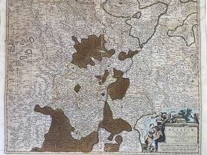
Landgraviatus Alsatiae inferioris Novissima Tabula." - Elsass Alsatia Baden - 1661-1680. Kolorierter Kupferstich.
Verlag: Amsterdam, Visscher, 1680
Buch Erstausgabe
Kupferstich, Koloriert. 1 Bll., Koloriert, Darstellungsgröße, 56 x 46 cm Karte in noch guter Erhaltung. Karte sauber. Zum Randbereich stellenweise ein wenig gewellt. Leichte Lagerspuren vor vormaliger Faltung der Karte sichtbar. Im unteren, linken Kartenbereich mit hinterlegten, gering sichbaren Einriss. Sprache: Deutsch Gewicht in Gramm: 1050.
-

Plan de la ville et citadelle de Lille; Afbeeldinge van de stercke stad Ryssel
Verlag: Nicolaas Visscher, Amsterdam, 1708
Anbieter: Argosy Book Store, ABAA, ILAB, New York, NY, USA
Bewertung:

unbound. Map. Uncolored engraving. Image measures 19.25" x 21". Sheet measures 20.5" x 24.25". This detailed map of Lille or Rijsel shows the city in northern France and its surroundings in exquisite detail. The citadel and fortified city, including streets and buildings noted. Surrounding farmlands are shown with beautifully rendered windmills and houses along with mountains and forests. Depicts the city during the War of the Spanish Succession when the city was occupied by the Dutch. The map is in very good condition with no chips or tears and minor staining near top centerfold. Nicolaes Visscher II, was a Dutch cartographer, publisher and engraver active from the late 17th century to the early 18th century. This is a nice example of his work.
-
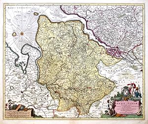
Ducatus Bremae et Ferdae maximaeque partis Ducatus Stormariae, Comitatus Oldenburgi, Albis, Visurgisque fluminum novissima
Verlag: Visscher, N., Amstredam, 1680
Bremen-Verden. "Ducatus Bremae et Ferdae maximaeque partis Ducatus Stormariae, Comitatus Oldenburgi, Albis, Visurgisque fluminum novissima descriptio". Orig. copperplate engraving, N. Visscher, ca. 1680. Orig. old colouring. With figure title cartouche wit a coat of arms and a cartouche with the scale of map. 46,5:56,5 cm. A map of Duchy of Bremen - Verden. With the city of Bremen on the left and the city of Hamburg on the right.
-
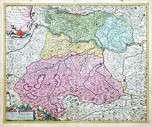
Austriae Archiducatus Pars Superior
Verlag: Visscher, Nicolas, Amsterdam, 1690
Upper Austria. "Austriae Archiducatus Pars Superior, in omnes ejusdem Quadrantes Ditiones accuratissime et distincte delineata". Orig. copperplate engraving, N. Visscher, Amsterdam, ca. 1690. Orig. old colouring. With figure title-cartouche and another figure cartouche with the scale of map, explanatory notes and a coat-of-arms. 47:57,5 cm (18 1/2 x 22 3/4 inch.). A decorative map of Upper Austria with Linz, Wels and Enns in the centre. - Very nice old colouring.
-
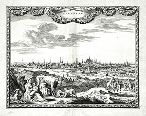
Nurnberg
Verlag: Visscher, N., Amsterdam, 1658
Nuremberg. "Nurnberg". Orig. copperplate engraving after P. H. Schut drawing. Published by N. Visscher, 1658. With ornamental title cartouche and figures in the foreground. 21,5:28 cm (8 1/5 x 11 inch.). Koeman IV, map 3130, ed. 451:1-3, state 1. - A view of Nurember in ornamental border.
-
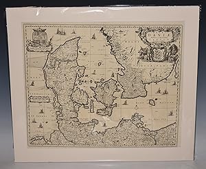
LARGE Antique Map of Denmark Regni Daniae, Novißima at Accuratißima Tabula.
Verlag: Amsterdam 1696, 1696
Anbieter: PROCTOR / THE ANTIQUE MAP & BOOKSHOP, DORCHESTER, Vereinigtes Königreich
Verbandsmitglied: PBFA
Bewertung:
Decorative double sheet Copperplate engraved map Uncoloured, The map shows all of Denmark, the northern tip of Germany and the southern tip of Sweden. The land is fully engraved with mountains, forests and cities, while the sea is filled with various types of ships, including two engaged in battle. The title cartouche is quite elaborate with a host of livestock, putti, and two wild men with clubs standing guard over the coat of arms in the center. The crest of King Christain V balances the left of the map. In very good condition. Strong impression. Held in ivory mount with hard back. Uncoloured. Engraved Size 23.5 x 20 inches Mount Size 27.5 x 24 inches.
-

Exactissima Tabula Sedis Belli Palatinatus ad Rhenum, Vormaciensis et Spirensis Episcopatus, Bibontini Ducatus sed etiam plurimae Moguntini Archiepiscopatus, et aliae adjacentes et insertae Regiones distincte osteduntur per Nic. Visscher Amst. cum Privil. Ordin. General. Belgii Foeder. Altkolorierte Kupferstichkarte m. Flächenkolorit.
Verlag: Nicolaus Visscher (II.) ca. 1690., Amsterdam,, 1690
Karte
Plattengröße: 45,5 x 57 cm, rechts oben ausgemalte Titelkartusche m. Wappen, Putti & barbusigen allegorischen Frauen, links unten Kartusche mit Legende und Maßstab, ZUSTAND 1.
-
Plattengröße: 58 x 46 cm, rechts oben ausgemalte Titelkartusche v. Gilliam van der Gouwen, links unten Legende und Maßstab, ZUSTAND 1. Zeigt das Gebiet zwischen Rhein, Main, Lahn, Neckar: Wetzlar, Speyer, Koblenz, Mainz, Frankfurt, Wertheim.
-
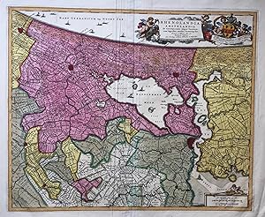
RHENOLANDIA, AMSTELANDIA Et Circumjacentia aliquot Territoria, cum Aggeribus, (.)
Verlag: Petrus Schenk II, 1725
Anbieter: Antiquariaat Dat Narrenschip, Middelburg, Niederlande
Bewertung:
Karte
No Binding. Zustand: Very Good. Kaart van Rijnland en Amstelland. Het westen boven. Titel en uitgeversimpressum bovenaan op een draperie omgeven door wolken en putti; rechts daarvan een banderol met opdracht van Nicolaes Visscher aan Johannes Hudde met diens wapen, eveneens omgeven door putti. Rechtsonder de schaalstokken in cartouche. In de Noordzee een windroos. Rugzijde blank. Oudtijds gekleurde kopergravure, uitgegeven te Amsterdam omstreeks 1725 door Petrus Schenk II. De kaart werd vervaardigd door Nicolaas Visscher in het laatste kwart van de zeventiende eeuw. Meerdere niet oorspronkelijke vouwen en plooien in het papier. Afmetingen (afbeelding): 46 x 56 cm.
-
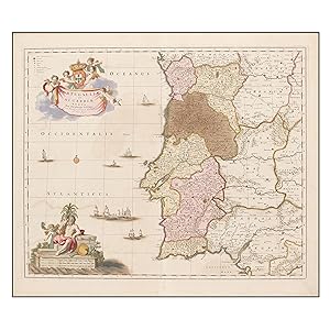
PORTUGALLIAE ET ALGARBIAE REGNA 1680
Erscheinungsdatum: 1680
Karte
Sin Encuadernar. Zustand: Bien. Materia: Mapa antiguo de la segunda mitad del siglo XVII. Portugal. Algarve - Nicolaes Visscher. Publicación: Atlas Minor Sive Geographia Compendosia, . Amsterdam, 1683-1696. Descripción: Mapa de Portugal que abarca también suroeste de Espańa. Escala también expresada en otras unidades. Orientado con lis coloreados solo los cuadrantes 2 y 3. Relieve por montes de perfil y sombreado. Márgenes graduados. Red de meridianos y paralelos. Red hidrográfica. Costas sombreadas. Ciudades representadas por pequeńos círculos o por conjuntos de edificaciones según su importancia. Cartela en tela con escudos y angelotes. Clave por símbolos de los obispados y arzobispados. Escalas enmarcadas con representación alegórica y vegetal en el margen inferior izquierdo. Embarcaciones de la época. Coloreado de época. Medidas: 46 x 56'5 cm [huella], 54 x 62 cm [papel]. Conservación: Buen estado. Ligeras marcas de humedad. Biografía del autor: Nicolaes Visscher fue un grabador, cartógrafo y editor neerlandés y descendiente de de Claes Janszoon Visscher. Su hijo, Nicolaes Visscher II, también trabajó con él y continuó la tradición de la elaboración de mapas de la familia después de su muerte. RES1 Este artículo necesita permiso de exportación / This item needs an export permit.
-
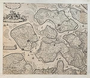
Comitatus Zelandiae Novissima Delineatio
Verlag: Nicolaas Visser, Amsterdam, 1690
Anbieter: Argosy Book Store, ABAA, ILAB, New York, NY, USA
Bewertung:
unbound. Map. Engraving with extended publisher margins, and no centerfold. Image measures 18 1/4 x 21 5/8", Sheet measures 20 7/8 x 24 3/4". Page number written in ink upper right margin. Striking map of Zeeland, the westernmost province of the Netherlands. Showing the islands of Walcheren, Beveland, Schouwen and Tholen within the Scheldt estuary, and Flanders in the south. The map illustrates polders, topography, roads, town and fortified Cities. The title cartouche credits Nicolas Visscher, and the imprint of his father, Claes Janszoon Visscher, is noted in the lower right. Claes Visscher (1587-1652) was the founder of the family business of engravers and publishers based in Amsterdam. Nicolaes I (1618-1679) worked with his Father and continued the business. His son Nicolaes Jansz. II inherited the business with his wife Elizabeth Visscher who ran it on her own after he died for more than 20 years. Hard to find.
-
LARGE Antique Regiae Celsitudinis Sabaudicae Status consistens in Sabaudiae ac Montisferrati Ducatus, Pedemontii Principatum. The State of His Royal Highness Savoy consisting of the Duchy of Savoy and Montisferrat, the Principality of Piedmont.
Verlag: Amsterdam, F. de Wit, 1690, 1690
Anbieter: PROCTOR / THE ANTIQUE MAP & BOOKSHOP, DORCHESTER, Vereinigtes Königreich
Verbandsmitglied: PBFA
Bewertung:
Decorative double sheet Copperplate engraved map with original handcolour, The map is decorated with The title in a magnificent cartouche decorated with angels and divinities and the arms of the Duke of Savoy. In very good condition. Beautiful colouring. Held in ivory mount with hard back. Hand colouring. Engraved Size 23.5 x 20 inches Mount Size 27.5 x 24 inches.
-
Nassovia Principatus Cum omnibus ei pertinentibus Comitatibus Dominiis, ac Praefecturis, ut et confiniis intra. Lahnum Rhenum et Moenum Flumina, ad situm verum exacte delineatus ŕ Joh. Jac. Stetter U. J. L. Idstenio - Nassovia. Altkolorierte Kupferstichkarte m. Grenz- u. Flächenkolorit.
Verlag: Nicolas Visscher, um 1670., Amsterdam,, 1670
Karte
63,5 52,5 x cm, Plattengröße: 47 x 57 cm, links oben ausgemalte Titelkartusche mit 6 Wappen u. Putti, in der rechten unteren Ecke Kartusche mit Legende und Maßstab. ZUSTAND 1. Zeigt das Gebiet zwischen Lahn - Rhein - Main: Koblenz - Bingen; Koblenz - Giessen; Giessen - Frankfurt.
-
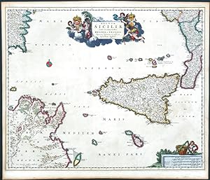
Regnum Siciliae
Verlag: Visscher, N., Amsterdam, 1680
Sicily. "Regnum Siciliae". Original copperplate engraving, N. Visscher, Amsterdam, 1680. Orig. old colouring. With decorative title-cartouche and a cartouche with the scale of map. 46,5:57 cm (18 1/4 x 22 1/2 inch.). Map of Sicily, Malta, the Aeolian Islands (Lipai Islands) and parts of Calabria, Corsica and North Africa.
-
Kein Einband. Zustand: Gut. Kolorierte Kupferstichkarte. Ca. 44 x 55 cm (Plattenrand). Mit Passepartout unter Glas in moderner Goldleiste gerahmt. 69 x 78 cm. - Stock- und fingerfleckig. Nicht ausgerahmt, daher mit möglichen Randläsuren. Versand nur ohne Rahmen. Karte.
-
Exactissima Helvetiae Rhaetiae, Valesia Caeterorumq Confoederatorum ut et finitimorum Populorum Regionum Tabula. / Illustrissimis, Potentissimis ac Florentissimis Rebus - Publicis Helvetiorum, Tigurinae, Bernensi Basiliensi Scaphusinae Novam hanc & postomnes alias Exactissimam Helvetiae Tabulam d.d.d.
Verlag: Nicolaes Visscher, Amsterdam
Anbieter: Alexandre Antique Prints, Maps & Books, Toronto, ON, Kanada
Bewertung:

Karte
Decorative cartouche in lower left corner features two putti, one representing the harvest, the other representing government., Size : 485x580 (mm), 19.09x22.83 (Inches), Original Hand Coloring Very Good; minor age toning, due to oxidation of the green pigment the map is laid down on acid-free paper for long term preservation.
-
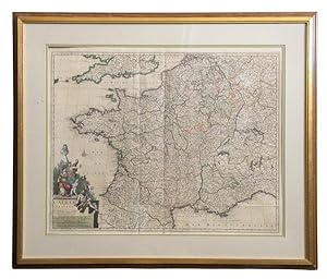
GALLIAE SEU FRANCIAE TABULA
Verlag: Visscher n.d. [1680-1720], Amsterdam, 1680
Anbieter: Second Story Books, ABAA, Rockville, MD, USA
Bewertung:

Karte
Hardcover. Galliae seu Franciae Tabula. A hand-colored copper engraved map of France published by Dutch cartographer Nicolaes Visscher. The map shows France as well as parts of England, Spain, Italy, Switzerland, and Germany. The bottom left corner features a spectacular cartouche with color engravings of Neptune, Mercury, and a female representation of France. The map has not been examined out of frame but appear to be in Very Good condition with slight toning and creasing from folding. The frame measures 38"x32.5" and the map itself measures 28.5"x23". Atlas Minor Sive Geographia Compendosia. 1374986. Arts & Antiques.
-
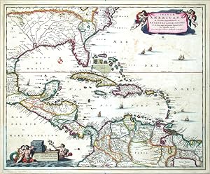
Insulae Americanae in Oceano Septentrionali
Verlag: Visscher, N., Amsterdam, 1680
Central America and Antilles (West Indies). "Insulae Americanae in Oceano Septentrionali ac Regiones Adiacentes .". Orig. copperplate engraving by N. Visscher, ca. 1680. Original old coloring. With decorative title-cartouche held by 4 cherubs, figure cartouche with the scale of map, windrose and 8 ships. 46:56 cm (18 x 22 inch.). Beautiful map of the Gulf of Mexico, the Antilles (Cuba, Haiti, Puerto Rico, Iamaica), the Bahama Islands, Florida, whole Central America and the north part of South America (Columbia, Venezuela).
-
Asiae Nova Delineatio
Verlag: Nicolaas Visscher, Amsterdam, 1690
Anbieter: Argosy Book Store, ABAA, ILAB, New York, NY, USA
Bewertung:
unbound. Map. Uncolored engraving. Image measures 17" x 21 1/2". Stains to upper center margins, otherwise in good condition. Impressive map of Asia, including Arabia, the Middle East, and the East Indies. Korea is accurately depicted as a peninsula, unlike many insular depictions the period. Visscher maps Japan according to delineations made by Mercator; while Hokkaido, labeled as Yedso on this map, is partially drawn as per the discoveries of De Vries. A dedication features the coat of arms of D. Henrico Spiegel, Senator of Amsterdam. Beautifully engraved with all tiny fonts legible. Claes Visscher (1587-1652) was the founder of the family business of engravers and publishers based in Amsterdam. Nicolaes I (1618-1679) worked with his Father and continued the business. His son Nicolaes Jansz. II inherited the business with his wife Elizabeth Visscher who ran it on her own for more than 20 years after his death. Hard to find.
-
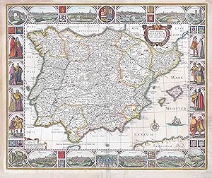
Nova et accurata Tabula Hispaniae : Praecipuis Urbis, Vestitu, Insignibus, at Antiquitatibus exornata.
Verlag: Amsterdam, 1638
Anbieter: Librería José Porrúa Turanzas S.A., Madrid, Spanien
Bewertung:
S.l.n.a. (Amsterdam, 1638). Mapa coloreado a mano en la Ă poca. (450 x 555)mm, en una hoja de (490 x 570)mm. Grabado en cobre de la penĂnsula IbĂ rica. Tercer estado, sin fecha en la cartela. Visscher fue el iniciador de una saga de cartĂ grafos, aprendiz de Hondius y encargado de la ornamentaciĂ n de los mapas de Ă ste, seguirá la tradiciĂ n iniciada de orlar algunos de sus mapas con vistas de ciudades, generalmente extraidas del "Civitatis Orbis Terrarum", asĂ como de personajes populares de las regiones representadas. Alrededor del mapa se encuentran las siguientes vistas: Pons Segovia, Madrid, Sevilla, Lixbona, Valladolid, Turris Herculis, S. Adriani M., Granata, Toledo, Monast. S. Laurent in Escurial, Fundatun a Philipp. II Hisp. Reg., Barcelona, Burgos y Algibe. En los laterales aparecen personajes femeninos y masculinos, todos ataviados con trajes de la Ă poca. Entre las vistas y los personajes hay escudos de los diferentes reinos de España y, en el centro del margen superior, el escudo real. 490x570mm. (19ÂĽx22½").
-
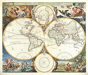
Orbis Terrarum Nova et Accuratissima Tabula
Verlag: Janssonius, Amsterdam, 1658
Karte
Kein Einband. Zustand: Gut bis sehr gut. Map of the World. "Orbis Terrarum Nova et Accuratissima Tabula. Auctore Nicolao Visscher". Orig. copperplate engraving, N. J. Visscher. Published by J. Janssonius in Amsterdam, 1658. Orig. old colouring. With title cartouche at top, 2 inset charts of the North and the South Pole ("Polus Arcticus" and "Polus Antarcticus") and highly decorative border illustrations around the map after N. Berchem. 47:56 cm (18 1/2 x 22 inch.). Shirley 406: "Nicolaas Visscher's new world map in two hemispheres can be regerded as the master forerunner of a number of highly decorative Dutch world maps produced throughout the remainder of the century". - Centerfold reinforced with Japanese paper, minore cracks in margins (outside of the printed area) proffesionally restored. - A very decorative map of the World. California depicted as an island.
-
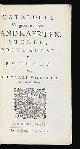
Catalogus Van groote en kleene Land-Kaerten, Steden, Print-Kunst En Boecken.
Verlag: Van Nicolaes Visscher, Op den Dam in de Visscher, [1682]., Amsterdam,, 1682
Anbieter: Daniel Crouch Rare Books Ltd, London, Vereinigtes Königreich
Verbandsmitglied: ABA ILAB PBFA
Bewertung:

Buch
Visscher family catalogue Twelvemo. 38-pages; contemporary marbled paper wrappers, backstrip torn with loss *6 A10, 2A4 (- 2A4, blank?) A rare example of the Visscher family catalogue, including a list of all the large and small maps, city views, and illustrations, for which they owned the final plates. It opens with the text of the patents awarded to Nicolaes Visscher in 1682 by the States General and the States of Holland. Claes Jansz Visscher established a printing house in Amsterdam specialising in art and cartography after studying under Jodocus Hondius, and published a well known panorama map of London in 1616. His son, Nicolas (also known as Claes) Visscher (1618 1679), followed in his footsteps and began to produce biblical maps to feed the demands for accessible scripture after the Reformation. He began to issue atlases under the name 'Atlas Minor' in 1664, which appear to have been made to order as their composition varies. He also published a celebrated and much-copied map of the Americas, 'Novissima et Accuratissima Totius Americae Descriptio'. Nicolas Visscher II (1649 1702) helped expand the business into one of the largest and most successful cartographic houses of its time. Visscher II specialised in military maps, including plans of sieges, although the workshop continued to produce biblical maps and maps of the Netherlands. He continued to issue the 'Atlas Minor'. After his death, his widow Elizabeth Verseyl continued to run the business, producing several editions of the' Atlas Maior' and 'Atlas Minor', and an atlas of maps of the War of the Spanish Succession. After Elizabeth died in 1726, the business was bought by Pieter Schenk. Provenance: Bibliothčque nationale de France in Paris, the Royal Library in Kopenhagen and the Herzog August Bibliothek in Wolfenbüttel (Germany).
-
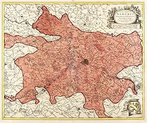
Zustand: guter Zustand. Belgien. Grafschaft Namur. Visscher. Comitatus Namurci Emendata Delineatio.Um 1660. Kupferstich, alt koloriert. Historische Landkarte, von Nicolaes Visscher d.Ä. 47,3 x 56,9, cm (Darstellung / Platte), 51 x 62,5 cm (Blatt).Blatt im Bereich der mittigen Bindefalte mit Einrissen und teils ausgedünntem Papier. Kleinere Einrisse auch im Randbereich. Insgesamt aber guter Zustand.Nicolaes Visscher d.Ä. (1618 - 1679 Amsterdam). Niederländischer Kupferstecher, Kartograph und Verleger, Mitglied der von seinem Vater Claes Janszoon Visscher begründeten niederländischen Kunsthändler-, Kupferstecher- und Verleger-Dynastie. Übernahm 1652 den Kunstverlag des Vaters und setzte die Atlanten- und Kartenwerke fort. Stach mit seinem Sohn Nicolaes Visscher d.J. zahlreiche eigene Druckplatten für die Atlanten Atlas Contractus, Atlas Minor und Germania Inferior. Rechts oben Titelkartusche mit Angabe des Autoren, darunter Entfernungsmaßstäbe. Rechts unten Wappen mit Legende. 47,3 x 56,9, cm (Darstellung / Platte), 51 x 62,5 cm (Blatt).
-
![Bild des Verkäufers für Baden-Württemberg. Landkarte. Visscher. S.R.I. Sueviae Circulus atq[ue] Ducatus una cum Inserts Et Adjacentibus Regionibus, accuratissime in earundem particulares Provincias divisum per Niclaum Visscher zum Verkauf von GALERIE HIMMEL](https://pictures.abebooks.com/inventory/md/md30954586946.jpg)
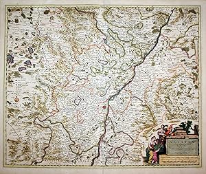
Zustand: guter Zustand. Baden-Württemberg. Landkarte. Visscher. S.R.I. Sueviae Circulus atq[ue] Ducatus una cum Inserts Et Adjacentibus Regionibus, accuratissime in earundem particulares Provincias divisum per Niclaum Visscher.Um 1700. Kupferstich, alt koloriert. Historische Landkarte, von Nicolaes Visscher d.J. 48,3 x 55,8 cm (Darstellung / Platte), 53 x 61,5 cm (Blatt).Die Karte zeigt das Gebiet Mannheim und Schwabach (Rednitz) im Norden, Augsburg und Landsberg am Lech im Osten, Werdenberg SG und der Zürichsee im Süden und Thann im Westen. Blatt mit mit mittiger Bindefalte. Insgesamt guter Zustand.Nicolaes Visscher d.J. (1649 - 1702 Amsterdam). Niederländischer Kupferstecher, Kartograf und Verleger, Mitglied der von seinem Großvater Claes Janszoon Visscher begründeten niederländischen Kunsthändler-, Kupferstecher- und Verleger-Dynastie. Stach gemeinsam mit seinem Vater Nicolaes Visscher d.Ä. zahlreiche Druckplatten für die Atlanten Atlas Contractus, Atlas Minor und Germania Inferior. Titelkartusche mit Angabe des Autoren oben links. Legende mit Entfernungsmaßstäben unten links. 48,3 x 55,8 cm (Darstellung / Platte), 53 x 61,5 cm (Blatt).
-
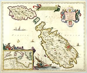
Insularum Meliate Vulgo Maltae et Gozae Novissima Delineatio
Verlag: Nicolaes I Visscher, Amstredam, 1680
Karte
Kein Einband. Zustand: Sehr gut. Malta, Gozo, Comino (Maltese Archipelago). "Insularum Meliate Vulgo Maltae et Gozae Novissima Delineatio". Orig. copperplate engraving, N. Visscher, Amsterdam, ca. 1680. Original old colouring. With figure title cartouche with a coat of arms, a cartouche with the scale of map held by 2 cherubs, several ships and a figure cartouche with inset map of the Western Mediterranean. 46:56,5 cm. A very decorative map of the Maltese Archipelago (Malta, Gozo and Comino) in the Mediterranean Sea. - A beautiful, splendidly coloured impression.
-
Nova Haec Tabula Galliae Lodovico XIIII Christianis Simo Regi Franciae et Navarrae Humillime Dedicatur a Nicolao Johannide Visscher.
Verlag: Nicolaes Jansz. Visscher c. 1683, Amsterdam, 1683
Anbieter: Alexandre Antique Prints, Maps & Books, Toronto, ON, Kanada
Bewertung:
Karte
Fourteen city views decorate the upper and lower borders of this handsome map of France under Louis XIV, while colourful depictions of various members of the First and Second Estates decorate the two sides of the map, with merely two dedicated to the massive Third Estate, "Cives" and "Rustici"., Size : 470x555 (mm), 18.50x21.85 (Inches), Hand Colored Small restoration at the upper margin, otherwise Very Good.
-

"Leodiensis Episcopatus im omnes subjacentes Provincias distincte divisus" - Liege Leuven Namur Dinant Aachen Düren Trier Jülich Limburg
Verlag: Amsterdam ca. 1650., 1650
Anbieter: Antiquariat Steffen Völkel GmbH, Seubersdorf, Deutschland
Bewertung:
Karte
Großformatige altkolorierte Kupferstich-Karte von ca. 1650. Rückseitig ohne Text. -- Blatt-Maße: ca. 53 x 61 cm. -- im unteren Mittelbug leicht eingerissen, sonst gut erhalten. || Large old colored engraved map from c. 1650. Without text on verso. -- slightly split on the lower part of the centerfold, otherwise in good condition. || Dies ist ein Original! - Kein Nachdruck! - Keine Kopie! -- This is an original! - No copy! - No reprint! la Gewicht in Gramm: 1550.
-
Hardcover. Zustand: very good. Flandriae Comitatus, map, anno 1690, Visscher N., size of the leaf: 52x62 cm., little brownish, restoration on below centerfold,
-
"Landgraviatus Alsatiae inferioris Novissima Tabula." - Elsass Alsatia Baden Karte map
Verlag: Amsterdam, Visscher um 1680., 1680
Anbieter: Antiquariat Steffen Völkel GmbH, Seubersdorf, Deutschland
Bewertung:
Karte
Original altkolorierte Kupferstich-Karte. Gutes Exemplar in seltenem Original-Verlagskolorit. -- Ohne Rückentext. -- Blatt-Maße: ca. 60 x 50,5 cm. -- in Mittelfalz etwas hinterlegt, sonst gut erhalten. || Original old colored engraved map. In very good condition with the rare original publishing coloring. Without text on verso. -- deposited on the middle fold, otherwise in good condition.|| Dies ist ein Original! - Kein Nachdruck! - Keine Kopie! -- This is an original! No copy! - No reprint! The Visschers were a famous and important Dutch family of engravers, cartographers, mapmakers and publishers. Claes Janszoon Visscher (1587-1652) was born in Amsterdam. He learned the art of etching and printing from his father, and helped grow the family printing and mapmaking business to one of the largest in his time. It was a family business; Nicolaes Visscher I (16181679), and Nicolaes Visscher II (16491702) were also mapmakers in Amsterdam. The trademark of the Visschers was a fisherman, after their name. A small fisherman would be strategically placed somewhere near water. Their map plates were reused for a century by other printers who unknowingly copied the entire plates, including the tell-tale fishermen. Observant scholars are thus able to trace the provenance of Bibles, maps, and landscapes from these signs. // Die Visscher waren eine berühmte und bedeutende niederländische Familie von Kupferstechern, Kartographen, Kartenmachern und Verlegern. Claes Janszoon Visscher (1587-1652) wurde in Amsterdam geboren. Er lernte die Kunst des Radierens und Druckens von seinem Vater und half dabei, das Druck- und Kartengeschäft der Familie zu einem der größten seiner Zeit auszubauen. Es war ein Familienunternehmen; Nicolaes Visscher I (16181679) und Nicolaes Visscher II (16491702) waren ebenfalls Kartenhersteller in Amsterdam. Das Markenzeichen der Visscher war ein Fischer, nach ihrem eigenen Namen. Dieser wurde auf ihren Druckwerken strategisch irgendwo in der Nähe von Wasser platziert. Ihre Platten wurden ein Jahrhundert lang von anderen Druckern wiederverwendet, die unwissentlich die gesamten Tafeln kopierten, einschließlich der verräterischen Fischer. Anhand dieses Markenzeichens können aufmerksame Gelehrte die Herkunft von Bibeln, Karten und Landschaften nachvollziehen. la Gewicht in Gramm: 1550.