
Gesamtpreis (1 Artikel Artikel):
Versandziel:

naval intelligence staff (13 Ergebnisse)
Direkt zu den wichtigsten Suchergebnissen
Suchfilter
Produktart
- Alle Product Types
- Bücher (12)
- Magazine & Zeitschriften (Keine weiteren Ergebnisse entsprechen dieser Verfeinerung)
- Comics (Keine weiteren Ergebnisse entsprechen dieser Verfeinerung)
- Noten (Keine weiteren Ergebnisse entsprechen dieser Verfeinerung)
- Kunst, Grafik & Poster (Keine weiteren Ergebnisse entsprechen dieser Verfeinerung)
- Fotografien (Keine weiteren Ergebnisse entsprechen dieser Verfeinerung)
- Karten (Keine weiteren Ergebnisse entsprechen dieser Verfeinerung)
- Manuskripte & Papierantiquitäten (1)
Zustand Mehr dazu
- Neu (2)
- Wie Neu, Sehr Gut oder Gut Bis Sehr Gut (Keine weiteren Ergebnisse entsprechen dieser Verfeinerung)
- Gut oder Befriedigend (5)
- Ausreichend oder Schlecht (2)
- Wie beschrieben (4)
Einband
Weitere Eigenschaften
- Erstausgabe (4)
- Signiert (Keine weiteren Ergebnisse entsprechen dieser Verfeinerung)
- Schutzumschlag (Keine weiteren Ergebnisse entsprechen dieser Verfeinerung)
- Angebotsfoto (3)
Sprache (2)
Gratisversand
Land des Verkäufers
Verkäuferbewertung
-
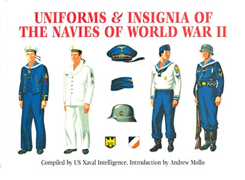
Uniforms and Insignia of the Navies of World War II
Anbieter: ThriftBooks-Dallas, Dallas, TX, USA
Verkäuferbewertung 5 von 5 Sternen

Hardcover. Zustand: Good. No Jacket. Missing dust jacket; Pages can have notes/highlighting. Spine may show signs of wear. ~ ThriftBooks: Read More, Spend Less.
-
Uniforms and Insignia of the Navies of World War II
Anbieter: ThriftBooks-Atlanta, AUSTELL, GA, USA
Verkäuferbewertung 5 von 5 Sternen
Hardcover. Zustand: Very Good. No Jacket. Former library book; May have limited writing in cover pages. Pages are unmarked. ~ ThriftBooks: Read More, Spend Less.
-
Uniforms and Insignia of the Navies of World War II
Anbieter: ThriftBooks-Atlanta, AUSTELL, GA, USA
Verkäuferbewertung 5 von 5 Sternen
Hardcover. Zustand: Good. No Jacket. Pages can have notes/highlighting. Spine may show signs of wear. ~ ThriftBooks: Read More, Spend Less.
-
Uniforms and Insignia of the Navies of World War II
Anbieter: ThriftBooks-Dallas, Dallas, TX, USA
Verkäuferbewertung 5 von 5 Sternen
Hardcover. Zustand: Good. No Jacket. Pages can have notes/highlighting. Spine may show signs of wear. ~ ThriftBooks: Read More, Spend Less.
-

A Handbook of Bulgaria Compiled by the Geographical Section of the Naval Intelligence Division, Naval Staff, Admiralty Classic Reprint
Anbieter: PBShop.store US, Wood Dale, IL, USA
Verkäuferbewertung 5 von 5 Sternen
PAP. Zustand: New. New Book. Shipped from UK. Established seller since 2000.
-
A Handbook of Bulgaria Compiled by the Geographical Section of the Naval Intelligence Division, Naval Staff, Admiralty Classic Reprint
Anbieter: PBShop.store UK, Fairford, GLOS, Vereinigtes Königreich
Verkäuferbewertung 4 von 5 Sternen

EUR 28,05
EUR 6,71 Versand
Versand von Vereinigtes Königreich nach USAAnzahl: 15 verfügbar
In den WarenkorbPAP. Zustand: New. New Book. Shipped from UK. Established seller since 2000.
-

Merchant Ships Identification
Verlag: Intelligence Division Naval Staff
Anbieter: Wonder Book, Frederick, MD, USA
Verkäuferbewertung 5 von 5 Sternen
Zustand: Fair. Acceptable condition. No Dust Jacket No date stated, ca. 1940s. (merchant ships, reference) A reading only copy. Boards/spine/hinges may be broken, detached, or missing. All pages of text are present, but they may include extensive notes/highlighting, be heavily stained, or detached. May be missing non-text pages (e.g. end pages, half title, title, frontispiece.).
-
Survival On Land & Sea.
Verlag: GPO, 1944, 1944
Anbieter: Wonder Book, Frederick, MD, USA
Verkäuferbewertung 5 von 5 Sternen
Erstausgabe
Zustand: Fair. First edition copy. . Dampstained. War Department Navaer 13-1-501. (Military History, Field manuals, Reference, survival guide).
-
German East Africa (Confidential) - Handbooks Prepared under the Direction of the Historical Section of the Foreign Office - No. 120
Sprache: Englisch
Verlag: Foreign Office, London, 1919
Anbieter: Dendera, London, Vereinigtes Königreich
Verkäuferbewertung 5 von 5 Sternen
Erstausgabe
EUR 412,06
EUR 28,58 Versand
Versand von Vereinigtes Königreich nach USAAnzahl: 1 verfügbar
In den WarenkorbSoft cover. Zustand: Very Good. 1st Edition. The confidential first edition dated March 1919, prepared for the British Delegation to the Paris Peace Conference (a second declassified edition made available to the public without the map appeared in 1920, retitled "Tanganyika (German East Africa)" and renumbered No. 113). Original grey printed card wraps 14x22cm. vi, 117pp, complete with the colour folding map in a back pocket. Very good, lightly bumped and creased to the corners, tanned to the spine, blue crayon number to the front. Map spotted, neatly folded with short closed fold tears. Chapters describe physical and human geography, political history (starting with Portuguese influence through to Arab rule, British and German interests, and native opposition), social and political conditions, and economy, with Treaty extracts in the Appendices. No authors are indicated, but it was a collective effort, with the series edited by George Walter Prothero, Director of the Historical Section, which had been established purposely by the Foreign Office. Histories were voluntarily contributed by experts, geography by Naval Intelligence Division staff, and economics by the Foreign Office War Trade Intelligence Department. The map is by the Geographical Section General Staff of the War Office: "General Map of German East Africa", GSGS No. 2814, War Office, July 1916. 80x78cm, 1/2M, bounded by Lake Victoria (N), the Swahili coast from Lamu to Pekavi with Zanzibar about midway (E), the border with Portuguese East Africa (S), and Lake Tanganyika (W). Features include railways, roads (mostly fit for light wheeled traffic), important tracks and routes, marshes, mission stations, and international boundaries. This edition appears to be very rare, with Worldcat and Library Hub locating copies at the British Museum and British Library only (OCLC 558925343).
-

ID 1211. A Manual of Alsace-Lorraine. June 1919. BRIGHT, CLEAN COPY
Verlag: Naval Staff Intelligence Department,, 1919
Anbieter: Island Books, Thakeham, West Sussex, Vereinigtes Königreich
Verkäuferbewertung 5 von 5 Sternen
Erstausgabe
EUR 129,50
EUR 26,52 Versand
Versand von Vereinigtes Königreich nach USAAnzahl: 1 verfügbar
In den Warenkorb8vo., First Edition; dark blue cloth, boards framed in blind, expertly rebacked to style, a very good, crisp, clean copy. 'Sold from an institution with its library markings on front free endpaper. 'This book is the property of HM Government. Its contents are not to be communicated either directly or indirectly to the Press, or to any person not holding an official position in HM Service. Attention is drawn to the Penalties attaching to any Infraction of the Official Secrets Act'. EXTREMELY SCARCE. Not recorded by Enser.
-
A Manual of Alsace-Lorraine: I. D. 1211
Verlag: United Kingdom, London, 1919
Anbieter: Ground Zero Books, Ltd., Silver Spring, MD, USA
Verkäuferbewertung 4 von 5 Sternen
Hardcover. 422 p. Includes: index, bibliography. Occasional footnotes. "For Official Use Only. " Good in good dust jacket. Ex-library. Usual library markings. Bookplate. Cover has some wear and soiling. Spine scuffed. Does not have accompanying Atlas with maps.
-
GEOGRAPHICAL HANDBOOK SERIES. B.R. 516, 516A & 516B.
Erscheinungsdatum: 1944
Anbieter: Anthony C. Hall, Bookseller ABA ILAB, Isleworth, MIDDX, Vereinigtes Königreich
Verbandsmitglied: ABA ILAB PBFA
Verkäuferbewertung 4 von 5 Sternen
EUR 147,16
EUR 25,72 Versand
Versand von Vereinigtes Königreich nach USAAnzahl: 1 verfügbar
In den WarenkorbHardback. Greece. 3 vols. 524, 430 & 587pp, 346 maps & diagrams & 398 plates 1944-5. *Vol. 1. Physical geography, History, Administration & Peoples. Vol. 2. Economic geography, Ports, & Communications. Vol. 3. Regional geography. Greece 15: Although by now inevitably, somewhat out of date, these volumes maintain much of their original value & are a mine of information on the physical & economic value of the country. Ex-library set., covers marked, contents good.
-
A Handbook of Syria (including Palestine).
Erscheinungsdatum: 1919
Anbieter: Maggs Bros. Ltd ABA, ILAB, PBFA, London, Vereinigtes Königreich
Verbandsmitglied: ABA ILAB PBFA
Verkäuferbewertung 5 von 5 Sternen
Manuskript / Papierantiquität Erstausgabe
EUR 1.118,45
EUR 30,86 Versand
Versand von Vereinigtes Königreich nach USAAnzahl: 1 verfügbar
In den WarenkorbFirst Edition. I.D. 1215. 8vo. Original black cloth, gilt lettering to spine; light wear to extremities, several tiny scuffs and stains to boards, small area of shiny tape residue to spine, a few short tears to hinges (not affecting stability of binding), otherwise near very good. Interior exceptionally clean and fresh. 723 pp. Naval Staff Intelligence Department, June, A scarce wartime handbook on Greater Syria, therefore covering present-day Syria, Lebanon and Palestine. Prepared by the Naval Staff Intelligence Department it includes an impressive range of information on everything from Military History to Agriculture. This copy, as with others we have seen, does not include the fourteen pages of illustrations apparently found in some examples. The note at the start of the handbook states it was something of a work in progress, originally intended as a two-volume publication (with a second vol. dedicated to 'Routes and Communications'), but stalled due to "the occupation of the country and the signing of the Armistice" (p.[5]). Scarce. LibraryHub locates five examples in the UK, at the University of Birmingham, BL, KCL, Oxford and UCL. OCLC adds no further examples, with no holding libraries in North America. .


