
Gesamtpreis (1 Artikel Artikel):
Versandziel:

geographical section general staff (32 Ergebnisse)
Direkt zu den wichtigsten Suchergebnissen
Suchfilter
Produktart
- Alle Product Types
- Bücher (16)
- Magazine & Zeitschriften (Keine weiteren Ergebnisse entsprechen dieser Verfeinerung)
- Comics (Keine weiteren Ergebnisse entsprechen dieser Verfeinerung)
- Noten (Keine weiteren Ergebnisse entsprechen dieser Verfeinerung)
- Kunst, Grafik & Poster (Keine weiteren Ergebnisse entsprechen dieser Verfeinerung)
- Fotografien (Keine weiteren Ergebnisse entsprechen dieser Verfeinerung)
- Karten (16)
- Manuskripte & Papierantiquitäten (Keine weiteren Ergebnisse entsprechen dieser Verfeinerung)
Zustand Mehr dazu
- Neu (Keine weiteren Ergebnisse entsprechen dieser Verfeinerung)
- Wie Neu, Sehr Gut oder Gut Bis Sehr Gut (1)
- Gut oder Befriedigend (21)
- Ausreichend oder Schlecht (3)
- Wie beschrieben (7)
Einband
Weitere Eigenschaften
- Erstausgabe (5)
- Signiert (1)
- Schutzumschlag (Keine weiteren Ergebnisse entsprechen dieser Verfeinerung)
- Angebotsfoto (31)
Sprache (2)
Gratisversand
- Kostenloser Versand nach USA (Keine weiteren Ergebnisse entsprechen dieser Verfeinerung)
Land des Verkäufers
Verkäuferbewertung
-

Upper Egypt edition of 29 April 41
Verlag: Genearl Staff, Egypt?, 1941
Anbieter: Book Express (NZ), Shannon, Neuseeland
Verkäuferbewertung 4 von 5 Sternen

Paperback. Zustand: Fair. some wear at folds -used by Flying Officer Ken Dawick (NZ) 111 Squadron (hur ricanes) MIddle East ww 2 linen backed.
-
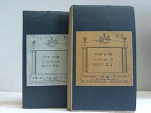
England and Wales. Ordnance survey maps: Ribblesdale / Kirkby Lonsdale & Hawees. Sheet 20 u. 25. Second War Revision 1940. 2 Karten
Anbieter: Celler Versandantiquariat, Eicklingen, Deutschland
Verbandsmitglied: GIAQ
Verkäuferbewertung 5 von 5 Sternen

Sifton, Praed & Co., London, 1940/1942. 2 auf Leinen gezogene, mehrfach gefaltete Karten, Scale: 1 Inch to a Mile, 75,5 cm x 53,5 cm, (leicht fleckig / private Anmerkung auf Titel)---- englisch - 192 Gramm.
-
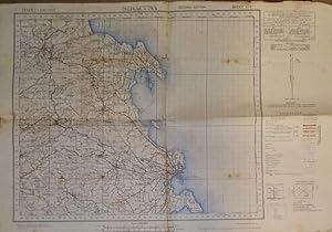
[Map] Iraq: Baghdad, Diyala & Kirkuk Divisions (Grid B I & AC No.2B) No. I-38 I Kifri - GSGS No. 3919, ID 9002 / 1059 - For Official Use Only
Sprache: Englisch
Verlag: Survey Directorate HQ Tenth Army, Calcutta, 1942
Anbieter: Dendera, London, Vereinigtes Königreich
Verkäuferbewertung 5 von 5 Sternen
Karte
EUR 53,79
EUR 29,02 Versand
Versand von Vereinigtes Königreich nach USAAnzahl: 1 verfügbar
In den WarenkorbNo Binding. Zustand: Fair. Three colour (black, red and brown) printed paper map 51x67cm. Fair only, neatly folded, tanned and spotted with pencil annotation to the front, minor loss to the intersections, some soiling to the verso. Geographical Section General Staff (GSGS) No. 3919 reprinted with corrections Calcutta July 1940, revised Calcutta Aug 1940 and April 1941, revised April 1942, published by the Survey Directorate HQ Tenth Army April 1942, reproduced by 4 Indian Field Survey Company. Issued in the tense period after the Anglo-Iraqi War, coverage is bounded by Zaghaitun Chai (NW), Dasht-i-Pataki (NE), Delli Abbas (SE), and Balad (SW) on a scale of 1 inch to 4 miles.Details include administrative boundaries, several classes of road (distinguishing metalled and unmetalled, cart tracks, camel tracks or trade routes, mule paths, footpaths, and doubtful or unsurveyed routes); 2 classes of railway (with the Baghdad - Kirkuk and Mosul - Baghdad Branches drawn); water wells, oil wells, mines, springs, mosques, forts, watch towers, deserted villages, numerous Arab camps, police posts, individually named plots, telephone lines and offices, the Tigris, wadis etc, with descriptive notes about terrain in the image. Marginal information includes a glossary, special road information for Mechanised Transport (regarding all weather roads, dry weather roads, turning points, cautions, etc).
-
German East Africa (Confidential) - Handbooks Prepared under the Direction of the Historical Section of the Foreign Office - No. 120
Sprache: Englisch
Verlag: Foreign Office, London, 1919
Anbieter: Dendera, London, Vereinigtes Königreich
Verkäuferbewertung 5 von 5 Sternen
Erstausgabe
EUR 418,40
EUR 29,02 Versand
Versand von Vereinigtes Königreich nach USAAnzahl: 1 verfügbar
In den WarenkorbSoft cover. Zustand: Very Good. 1st Edition. The confidential first edition dated March 1919, prepared for the British Delegation to the Paris Peace Conference (a second declassified edition made available to the public without the map appeared in 1920, retitled "Tanganyika (German East Africa)" and renumbered No. 113). Original grey printed card wraps 14x22cm. vi, 117pp, complete with the colour folding map in a back pocket. Very good, lightly bumped and creased to the corners, tanned to the spine, blue crayon number to the front. Map spotted, neatly folded with short closed fold tears. Chapters describe physical and human geography, political history (starting with Portuguese influence through to Arab rule, British and German interests, and native opposition), social and political conditions, and economy, with Treaty extracts in the Appendices. No authors are indicated, but it was a collective effort, with the series edited by George Walter Prothero, Director of the Historical Section, which had been established purposely by the Foreign Office. Histories were voluntarily contributed by experts, geography by Naval Intelligence Division staff, and economics by the Foreign Office War Trade Intelligence Department. The map is by the Geographical Section General Staff of the War Office: "General Map of German East Africa", GSGS No. 2814, War Office, July 1916. 80x78cm, 1/2M, bounded by Lake Victoria (N), the Swahili coast from Lamu to Pekavi with Zanzibar about midway (E), the border with Portuguese East Africa (S), and Lake Tanganyika (W). Features include railways, roads (mostly fit for light wheeled traffic), important tracks and routes, marshes, mission stations, and international boundaries. This edition appears to be very rare, with Worldcat and Library Hub locating copies at the British Museum and British Library only (OCLC 558925343).
-
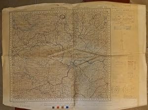
[Map] Iran, Iraq: Astans No. 5 & 6. Kut Al Imara Division (Grid B International No. I-38 V) Series K 501 (GSGS 3919), Sheet I-38Q, Edition 3-GSGS
Sprache: Englisch
Verlag: War Office, Calcutta, 1948
Anbieter: Dendera, London, Vereinigtes Königreich
Verkäuferbewertung 5 von 5 Sternen
Karte
EUR 59,77
EUR 29,02 Versand
Versand von Vereinigtes Königreich nach USAAnzahl: 1 verfügbar
In den WarenkorbNo Binding. Zustand: Fair. Three colour (black, red and brown) printed paper map 48x74cm. Fair only, folded, creased, with staining to the image, and the international boundary emphasised in red crayon. Produced as part of Series K501 or Geographical Section General Staff (GSGS) No. 3919, reprinted from IDR 9002/4678 and first published by the War Office in August 1942, this 3rd Edition was reproduced by the War Office in 1948, printed for the Directorate of Military Survey (War Office and Air Ministry) by the Ordnance Survey. This edition dates to signing the Anglo-Iraqi Treaty (15 Jan 1948), which committed to joint British-Iraqi military planning, and continued British control of foreign affairs. Most of this shows Iran, with the area bounded by the Zagros Mountains (NE), and the border with Iraq close to Mehran (SW) on a scale of 1 inch to 4 miles. Details include administrative boundaries, several classes of road (distinguishing metalled and unmetalled, cart tracks, camel tracks or trade routes, mule paths, footpaths, and doubtful or unsurveyed routes, widths, suitability for bridges, turning or passing places etc); railways; caravanserais, post, telegraph, landing grounds; water wells oil wells, mines, springs, mosques, forts, watch towers, deserted villages, police posts, customs posts etc, with descriptive notes about terrain in the image.
-
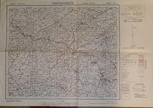
CALTAGIRONE. Sheet 273 of the "Carta d'Italia".
Verlag: War Office, 1942
Anbieter: studio bibliografico pera s.a.s., LUCCA, LU, Italien
Verkäuferbewertung 5 von 5 Sternen
No legatura. Zustand: buone. 2^ edizione. Carta del periodo bellico, a colori, in formato cm.43,6x63,5. Testo inglese. 50 gr.
-
TERMINI IMERESE. Sheet 259 of the "Carta d'Italia".
Verlag: War Office, 1942
Anbieter: studio bibliografico pera s.a.s., LUCCA, LU, Italien
Verkäuferbewertung 5 von 5 Sternen
No legatura. Zustand: buone. 2^ edizione. Carta del periodo bellico, a colori, in formato cm.43,6x63,5. Testo inglese. 50 gr.
-
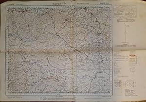
PATERNO'. Sheet 269 of the "Carta d'Italia".
Verlag: War Office, 1942
Anbieter: studio bibliografico pera s.a.s., LUCCA, LU, Italien
Verkäuferbewertung 5 von 5 Sternen
No legatura. Zustand: buone. 2^ edizione. Carta del periodo bellico, a colori, in formato cm.43,6x63,5. Testo inglese. 50 gr.
-
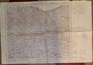
SIRACUSA. Sheet 274 of the "Carta d'Italia".
Verlag: War Office, 1942
Anbieter: studio bibliografico pera s.a.s., LUCCA, LU, Italien
Verkäuferbewertung 5 von 5 Sternen
No legatura. Zustand: buone. 2^ edizione. Carta del periodo bellico, a colori, in formato cm.43,6x63,5. Testo inglese. 50 gr.
-
BENEVENTO. Sheet 173 of the "Carta d'Italia".
Verlag: War Office, 1943
Anbieter: studio bibliografico pera s.a.s., LUCCA, LU, Italien
Verkäuferbewertung 5 von 5 Sternen
No legatura. Zustand: buone. 2^ edizione. Carta del periodo bellico, a colori, in formato cm.48x62. Testo inglese. Tracce d'uso. 50 gr.
-

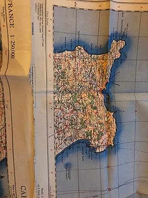
MONTE ETNA. Sheet 262 of the "Carta d'Italia".
Verlag: War Office, 1942
Anbieter: studio bibliografico pera s.a.s., LUCCA, LU, Italien
Verkäuferbewertung 5 von 5 Sternen
No legatura. Zustand: buone. 2^ edizione. Carta del periodo bellico, a colori, in formato cm.43,6x63,5. Testo inglese. 50 gr.
-
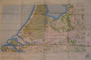
[Map] GSGS 4715 Sheet 426C Damascus (First Edition): Iraq - Jordan - Lebanon - Israel - Saudi Arabia - Syria (RAF 1:500,000 World Aeronautical Chart)
Sprache: Englisch
Verlag: War Office; Ordnance Survey, London, 1953
Anbieter: Dendera, London, Vereinigtes Königreich
Verkäuferbewertung 5 von 5 Sternen
Karte Erstausgabe
EUR 179,31
EUR 29,02 Versand
Versand von Vereinigtes Königreich nach USAAnzahl: 1 verfügbar
In den WarenkorbNo Binding. Zustand: Very Good. 1st Edition. Colour printed paper map 74x58cm, with index map, keys and aeronautical data to the verso. Very good, neatly folded. This first GSGS edition dated 1953, was based on a USAF Pilotage Chart (1948, revised June 1952), with air information supplied by the Ministry of Defence as at November 1952, and reproduced by the Ordnance Survey in an edition of 5,000 in July 1953 (5,000/7/53). Centred on Syria and northern Jordan, coverage is bounded by Beirut (NW), and the Syria-Iraq, Jordan-Iraq, and Jordan-Saudi borders (E, SE). The Haifa branch of the Iraq Petroleum Company Pipeline including its Pumping Stations runs across the lower section almost parallel with the Syria-Jordan border. A significant section of the Trans-Arabian Pipeline (Tapline) which began operation in 1950 is also drawn. Altitude is colour shaded. Extensive detail is included for culture (built up areas, railways, roads, miscellaneous including oil), topography, hydrography, and aeronautical information.
-
[Libyan Desert Map] Mount Uweinat (Anglo-Egyptian Sudan, Egypt, Libya) - RAF 1:1,000,000 Aeronautical Chart GSGS 4695 Sheet 568, First Edition
Sprache: Englisch
Verlag: War Office, London, 1954
Anbieter: Dendera, London, Vereinigtes Königreich
Verkäuferbewertung 5 von 5 Sternen
Karte Erstausgabe
EUR 209,20
EUR 29,02 Versand
Versand von Vereinigtes Königreich nach USAAnzahl: 1 verfügbar
In den WarenkorbNo Binding. Zustand: Very Good. 1st Edition. Colour map 74x57cm. Very good, neatly folded, with faint pencil note to the lower margin ("Nasar's Corner"). This sheet, dating to the early years of the Egyptian Republic, was based on a USAF World Aeronautical Chart dated March 1953. Coverage is bounded by the Gilf Kebir Plateau (N), Selima Oasis (uninhabited) (SE), the Libyan / Anglo-Egyptian Sudan border (SW), and Jebels Uweinat and Arkenu (W). Altitude is shown by colour tinting. Geographical features are accompanied by numerous captions describing the terrain such as variations in sand and gravel, barchan dune formations, etc. The "Memorial monument" south of Gilf Kebir would be the Prince Kemal el-Din Monument, which Laszlo Almasy had built in 1934 for his late patron and friend (1874-1932) close to where he had discovered the Cave of Swimmers. Among the several criss-crossing tracks would be the Darb al Arbain (or 40 Days Road), identifiable by its stops at Laqiya Arbain, Selima Oasis (where it splits), and El Shab.
-
[Map] Iraq: Diwaniya, Kut Al Imara and Muntafiq Divisions (Grid B International No. I-38 V) No. 2 H Kut Al Imara - GSGS No. 3919 - For Official Use Only
Sprache: Englisch
Verlag: Survey of India, Calcutta, 1940
Anbieter: Dendera, London, Vereinigtes Königreich
Verkäuferbewertung 5 von 5 Sternen
Karte
EUR 268,97
EUR 29,02 Versand
Versand von Vereinigtes Königreich nach USAAnzahl: 1 verfügbar
In den WarenkorbNo Binding. Zustand: Good. Three colour (black, red and brown) printed paper map 51x67cm. Good, neatly folded, lightly tanned, with closed fold and intersection tears. Geographical Section General Staff (GSGS) No. 3919 compiled and published originally under the direction of the Surveyor General of India 1922, reprinted with corrections Calcutta July 1940, revised Calcutta October 1940, heliozincographed at the Survey of India Offices, Calcutta. This was issued in a period of growing anti-British tension that would culminate in the Coup and Anglo-Iraqi War (April-May 1941) that was being stoked up by the Italian Legation in Baghdad, supported by the Grand Mufti of Jerusalem Amin al-Husseini, who was living in exile there. This highly strategic area would soon be covered by the British to retake Baghdad. With Kut al Imara to the right of centre, coverage is bounded by Al Aziziya (NW), Jassan (NE), Afaq and Hajil (SW) on a scale of 1 inch to 4 miles. Details include administrative boundaries, several classes of road (distinguishing metalled and unmetalled, cart tracks, camel tracks or trade routes, mule paths, footpaths, and doubtful or unsurveyed routes) with notes in the image on suitability for Mechanised Transport (MT); railways; landing grounds; water wells and availability of water, oil wells, mines, springs, mosques, forts, watch towers, deserted villages, police posts, individually named plots, telephone lines and offices, the Tigris, wadis etc, with descriptive notes about terrain in the image (including several with dated water depth measurements taken during WW1).
-
Homs - Beirut Sheet - Syria and Lebanon - War Office Map - 1910
Sprache: Englisch
Verlag: The War Office, 1910
Anbieter: Hornseys, Ripon, Vereinigtes Königreich
Verbandsmitglied: PBFA
Verkäuferbewertung 5 von 5 Sternen
EUR 328,74
EUR 29,02 Versand
Versand von Vereinigtes Königreich nach USAAnzahl: 1 verfügbar
In den WarenkorbNo Binding. Zustand: Very Good. HOMS - BEIRUT SHEET. Syria and Lebanon. British War Office map of the Ottoman Levant. Geographical Section, General Staff, December 1910. Folding map dissected onto linen and contained within original marbled Sifton, Praed & Co. covers. Detailed topographical mapping extending from the Mediterranean coast to Damascus and the Syrian interior, including Beirut, Tripoli, Sidon, Baalbek and Homs. Relief shown by hachuring with roads, railways, telegraph lines, caravan routes and administrative boundaries marked throughout. Overprinted "FOR OFFICIAL USE ONLY". An historically important pre-First World War map issued shortly before the collapse of Ottoman authority in the region and the creation of modern Lebanon and Syria. Sheet size 82.4 x 66 cm. Some staining verso which is visible in the Mediterranean Sea area of the map. Slight creasing and handling wear. Very good overall. Scarce.
-
[Map] Libya & Egypt (Geographical Section General Staff No. 2850)
Sprache: Englisch
Verlag: War Office, London, 1932
Anbieter: Dendera, London, Vereinigtes Königreich
Verkäuferbewertung 5 von 5 Sternen
Karte
EUR 388,51
EUR 29,02 Versand
Versand von Vereinigtes Königreich nach USAAnzahl: 1 verfügbar
In den WarenkorbNo Binding. Zustand: Good. Colour map, 1/3M or 47.35 miles to the inch, 97x62cm. Good, slightly unevenly folded, with some patches of staining, and small holes at intersections. Originally published in 1918, this includes revisions to boundaries and railways with minor corrections dated 1931. It was printed at the War Office in 1932, contemporary with pioneering explorations in the Libyan Desert. This is shown in some detail, including the Oases of Kharga, Dakhla, Farafra, Baharia, Siwa, Kufra, and smaller ones, dune fields by stippling. Of great interest are the numerous tracks, among them Darb el Arbain, Darb el Tawil, the Great Caravan Route to Wadai, Caravan Route to Kufra etc, as well as traces of an old route to passing through an uninhabited oasis with little water south of Kufra. G. Owenat (Jebel Uweinat) is marked at the very lower edge. Notes describe the extent of vegetation, incidence of water, and the nature of the desert surface (eg, stone or sand). Spot heights.
-
[Map] South Arabia 1:250,000: Lahej - Series GSGS 4851 (K 563) - Edition 3
Sprache: Englisch
Verlag: D. Survey, War Office and Air Ministry, London, 1957
Anbieter: Dendera, London, Vereinigtes Königreich
Verkäuferbewertung 5 von 5 Sternen
Karte
EUR 418,40
EUR 29,02 Versand
Versand von Vereinigtes Königreich nach USAAnzahl: 1 verfügbar
In den WarenkorbNo Binding. Zustand: Good. 3rd Edition. Colour map 81x61cm, printed by 42 Survey Engineer Regiment (MELF No. 15383-5000/12/57). Good, slightly imperfectly folded, and creased along the edges especially. This covers part of the Sultanate of Lahej in the Aden Protectorate, with its capital in the SE corner. Dated December 1957, this was the 3rd edition to be issued in the same year (the others in Feb and June). At this time, the British feared that the Arab nationalist Sultan Ali bin Abdal Karim al Abdali would refuse to join the Federation of Emirates of South Arabia (a British brokered arrangement that would last from 1959-62), and would depose him in 1958. Features include international boundaries (demarcated or undefined), regional boundaries, the dispositions of numerous tribes, towns and villages of varying importance, roads, tracks, pases, wells, wadis (perennial or seasonal), shrines, tombs, fors, ruins, airports, airfields, landing grounds, etc. There is also an English-Arabic Glossary, Key to Pronunciation, and technical notes.
-
[Anglo-Iraqi War map] Baghdad - Iraq Desert 1:500,000, Not to be Published, Edition of 26 May 1941 (Geographical Section General Staff No. 3954)
Sprache: Englisch
Verlag: War Office, London, 1941
Anbieter: Dendera, London, Vereinigtes Königreich
Verkäuferbewertung 5 von 5 Sternen
Karte
EUR 1.016,11
EUR 29,02 Versand
Versand von Vereinigtes Königreich nach USAAnzahl: 1 verfügbar
In den WarenkorbNo Binding. Zustand: Very Good. Anglo-Iraqi War map, published during final preparations to advance on Baghdad. Colour printed on linen-backed paper 64x85cm. Very good, neatly folded. Compiled by the War Office 1937, published by them 1938, printed by 512 (A Forward Survey) Company, Royal Engineers, May 1941, and reprinted with complete footnotes dated Edition of 26 May 1941. Coverage is bounded by Baghdad and its environs (NW), the border with Iran (NE), and Nasiriya (SE), showing the courses of the Tigris and Euphrates. Other major settlements include Kut, Hilla, Najaf, Kufa, and Karbala. Details include international boundaries, railways and stations, camel caravan and motor routes, telegraph and post stations, watch towers, forts, mosques, police posts, ancient sites (Babylon, Ur, Arch of Ctesiphon, canals etc), bridges across barrages, ruined bridges, etc; extensive topographical features with unsurveyed areas marked, and descriptions in the image (eg, bushes 2' to 3' high); and air information including aerodromes, landing grounds, signals etc. Iraq was at this time ruled by Rashid Al-Gaylani, who in April deposed Prince Abd Al-Ilah in an Axis-backed coup, and laid siege to the major British imperial base at RAF Habbaniya west of Baghdad. With Churchill endorsing "all necessary force" the British hastily assembled a major expeditionary force from the Indian Army, Arab Legion, Assyrian Levies, and Iraqi loyalists, with leadership transferred to General Archibald Wavell (C-in-C Middle East Command) and Lieutenant-General Edward Quinan (commanding Iraqforce). It protected AIOC installations, secured Habbaniya on 18 May, then Fallujah on 23 May as a preliminary to the march on Baghdad. On 23 May Wavell flew to Basra to review reinforcements and instruct Quinan to prepare the advance on Baghdad. This map was produced the day before the advance from Basra began. On 27 May the 20th and 21st Indian Infantry (named the "Euphrates" and "Tigris Brigades") set off up each river by boat and road under Operations Regulta and Regatta, the latter via Kut. Progress was hampered by floods and destroyed bridges. Meanwhile a small RAF-backed ground force led by Major General Clark advanced from Habbaniya, prompting Al-Gaylani to flee to Persia with the Grand Mufti on 29 May. Abd Al-Ilah was reinstated on 1 June. This looks to be very rare, with Worldcat recording 1 location for the 1st edition 1938 (OCLC 756234518: Dresden University).
-
[Map on 2 Sheets] Geographical Section General Staff (GSGS) No. 3939. Air Survey of Eastern Approach to Jordan Valley North Sheet and South Sheet (Trans-Jordan 1:50,000)
Sprache: Englisch
Verlag: War Office, London, 1933
Anbieter: Dendera, London, Vereinigtes Königreich
Verkäuferbewertung 5 von 5 Sternen
EUR 1.016,11
EUR 29,02 Versand
Versand von Vereinigtes Königreich nach USAAnzahl: 1 verfügbar
In den WarenkorbNo Binding. Zustand: Very Good. One map complete in 2 sheets. Very good, neatly folded with dusting to the versos and small closed fold and intersection tears. Each sheet measures 104x77cm, printed in 3 colours with brown for contours, blue for water, black for transport links, with titles and labels in English and Arabic. Surveyed at the War Office 1931 from air photos by No14(B) Squadron RAF Ground Control under the direction of Major R.L. Brown, Royal Engineers. Drawn at the War Office 1932 and printed 1933 (1400/40). Heliographed at the OS 1933. Focusing on the Jordan River and its major tributaries, it may have been drawn to show the economic and strategic importance of Trans-Jordan's water resources to Mandatory Palestine's plans for agricultural development, power generation, and related Zionist settlement. The combined area is bounded to the north by the Jordan River from its outflow at Lake Tiberias (NW) inland to Ain et Turab (NE), and to the south by the Zarqa River (Nahr ez Zerka) inland as far as Jerash. Features include roads and tracks distinguishing those fit for Mechanical Transport, actual or proposed railways, trig stations, swamps, springs, telegraph, telephone, and police posts. The upper part of the Valley shows the development of Moshavot and Kibbutzim including Deganiye (Degania Alef), Umm Juniye ("Jewish"), Umm Junieh ("Persian"), Kinnereth ("Co-op"), Menahamiya, etc. The Rutenberg Power Station labelled close to the confluence of the Yarmouk River was nearing completion in the year of the RAF survey, and it began supplying Palestine in 1932. This major project was part of a significant concession Mandatory Palestine granted to Pinhas Rutenberg via his Palestine Electric Company. It involved several new hydro-electric power projects with others at Tel Aviv, Haifa, and Tiberias, which eventually supplied all of Palestine. Close by is a Police Station, and the Jezreel Valley Railway running south from Samakh as part of the Haifa to Dera'a branch of the Hejaz Railway. Rare with Worldcat and Library Hub locating 7 copies between them (Oxford, Cambridge, BL, NERC, NLS, LoC, National Library of Australia).
-
![Bild des Verkäufers für VICO EQUENSE. [E Isola di Capri]. Sheet 196 of the "Carta d'Italia". zum Verkauf von studio bibliografico pera s.a.s.](https://pictures.abebooks.com/inventory/md/md31103421933.jpg)
VICO EQUENSE. [E Isola di Capri]. Sheet 196 of the "Carta d'Italia".
Verlag: War Office, 1943
Anbieter: studio bibliografico pera s.a.s., LUCCA, LU, Italien
Verkäuferbewertung 5 von 5 Sternen
No legatura. Zustand: buone. 2^ edizione. Carta del periodo bellico, a colori, in formato cm.49x62. Testo inglese. Tracce d'uso. 50 gr.
-
Romania 1:000,000 O.S.Maps 1944 (55 Original full colour wartime dated Maps)
Verlag: War Office, 1944
Anbieter: WORLD WAR BOOKS, TUNBRIDGE WELLS, Vereinigtes Königreich
Verbandsmitglied: PBFA
Verkäuferbewertung 5 von 5 Sternen
Erstausgabe
EUR 209,20
EUR 14,91 Versand
Versand von Vereinigtes Königreich nach USAAnzahl: 1 verfügbar
In den WarenkorbSoft cover. Zustand: Very Good. No Jacket. 1st Edition. Interesting set of 55 original Ordnance Survey of Romania, full colour and produced by the War Office from the official Romanian 1:100,000 sheets mainly dated 1939.Most sheets c. 80 cms x 60 cms and dated either 1944 or 1943. Earliest numbered Sheet 2060 finishing at 6065. Not a complete run as far as we can tell but 55 all printed "First Edition" Modest stamp to margin of Kings College London. The 55, all in very good condition. Likely to be most sensibly shipped in the UK due to weight and size.
-
Original Maps of Caen & Cherbourg 1:250,000 War Office 1942
Verlag: War Office, UK, 1942
Anbieter: WORLD WAR BOOKS, TUNBRIDGE WELLS, Vereinigtes Königreich
Verbandsmitglied: PBFA
Verkäuferbewertung 5 von 5 Sternen
EUR 268,97
EUR 14,91 Versand
Versand von Vereinigtes Königreich nach USAAnzahl: 1 verfügbar
In den WarenkorbPaper. Zustand: Very Good. No Jacket. 3rd Edition. Historic wartime original Maps of the D-Day invasion area. One titled Caen and covering a large area of Normandy partly including the Cherbourg peninsular and East to just beyond Caen 1:250,000 Sheet 8 No 2738 3rd Edition. Full colour and in very nice condition and Published in August 1942 The second titled Cherbourg completes the coverage up the peninsular (its the adjacent sheet) again in full colour 1:250,000 Sheet 3a 3rd Edition August 1942. In very nice condition. See images. The two original maps ship from the UK.
-
British World War II Map of Walcheren-Amsterdam
Verlag: British Military, England, 1944
Anbieter: RareNonFiction, IOBA, Ladysmith, BC, Kanada
Verbandsmitglied: IOBA
Verkäuferbewertung 5 von 5 Sternen
Karte
Paperback. Zustand: Very Good. Second Edition. 38" wide by 25.5" high. Dated June, 1944. Moderate wear. Nice copy.
-
[Map] Asia 1/1M, GSGS 2555, NG-40, Bandar Abbas
Verlag: War Office, London, 1945
Anbieter: Dendera, London, Vereinigtes Königreich
Verkäuferbewertung 5 von 5 Sternen
Karte
EUR 567,83
EUR 29,02 Versand
Versand von Vereinigtes Königreich nach USAAnzahl: 1 verfügbar
In den WarenkorbHardcover. Zustand: Fine. 3rd Edition. Colour map 76x65cm mounted on linen and folded into a gilt-titled burgundy cloth case 18x28cm. Fine. This is the 3rd edition 1945, reproduced by the Ordnance Survey from MDR I/12054 1944, with air information from RAF Middle East HQ dated Dec 1944. About centred on the Strait of Hormuz, this covers the Arabian side of the Arabian / Persian Gulf and Gulf of Oman from Qantar to Al Qasbiyat (naming Abu Dhabi, Dubai, Sharjah, Ajman, Umm al Quwain, Ras al Khaimah, Fujairah and Independent Oman) and inland to Buraimi and Hafit. On the Iranian side it covers the Shibkuh Coast to Ras Tank, and inland to the north of Lar, with steamer service routes indicated from Bandar Abbas to Bushire and Muscat. Extensive geographical information is supported by Arabic-English and Iranian-English glossaries.
-
Persia and Afghanistan.
Verlag: London War Office April, 1903
Anbieter: Shapero Rare Books, London, Vereinigtes Königreich
Verbandsmitglied: ABA ILAB PBFA
Verkäuferbewertung 5 von 5 Sternen
Karte Signiert
EUR 896,57
EUR 17,41 Versand
Versand von Vereinigtes Königreich nach USAAnzahl: 1 verfügbar
In den WarenkorbLithographed folding map printed in colours, 88.5 x 59.5 cm. dissected into 18 sheets mounted on linen, scale 1 inch to 64 miles, original brown cloth lettered in gilt, a very good copy. A wonderful map of Central Asia showing Persia and Afghanistan at the denouement of the Great Game. This map was published just 8 months before the departure of the Younghusband expedition in December 1903 and shows the Trans-Caspian Railway along the border of Russia through Samarkand and Bokhara to Baku. The Anglo-Russian Entente would be signed in 1907 effectively ending the Great Game and securing Russia's advancement up to the Iranian and Afghani borders.
-

Vladivostok
Verlag: US War Office, [Washington DC], 1946
Anbieter: Rulon-Miller Books (ABAA / ILAB), St. Paul, MN, USA
Verbandsmitglied: ABAA ILAB RMABA
Verkäuferbewertung 5 von 5 Sternen
Broadside map, second edition, 32.5 x 24 in., 1:1,000,000 scale; depicting elevations, depths, roadways and train routes, settlements, etc. Fine. A.M.S. 5301, NK 52.
-
[ Great Britain and Northern Ireland ] Map of Areas Dangerous to Flight - 4th Edition: March 1947 (See Note to Airmen No. 72 / 1947) - Geographical Section General Staff No. 3787
Verlag: War Office, London, 1947
Anbieter: Dendera, London, Vereinigtes Königreich
Verkäuferbewertung 5 von 5 Sternen
Karte
EUR 149,43
EUR 29,02 Versand
Versand von Vereinigtes Königreich nach USAAnzahl: 1 verfügbar
In den WarenkorbNo Binding. Zustand: Good. 4th Edition. Black and red printed folding paper map 76 x 102cm. Good condition except for a triangular piece to the bottom left which had been torn off and resecured with clear tape to the recto. This map was originally transferred and printed at the War Office in 1936. This adapted edition (5,000 copies printed in March 1947) features annotations printed in red, Numbers on or adjacent to Danger Areas indicate the maximum danger height in thousand of feet. The letter "A" indicates that aircraft may be participating in range practice within marked areas. The letter "B" indicates areas where captive balloons may the flown. The letter "P" indicates Portsmouth and Portland Naval Exercise Areas.
-
![Bild des Verkäufers für [Map]: Ordinance Survey of Great Britain; England, South East and London. Air Sheet 12. zum Verkauf von G. F. Wilkinson Books, member IOBA](https://pictures.abebooks.com/inventory/md/md31897657437.jpg)
[Map]: Ordinance Survey of Great Britain; England, South East and London. Air Sheet 12.
Verlag: War Office, London, 1942
Anbieter: G. F. Wilkinson Books, member IOBA, GRASS VALLEY, CA, USA
Verbandsmitglied: IOBA
Verkäuferbewertung 4 von 5 Sternen
Karte
Map. Zustand: Good. Pinholes and short tears down center fold, and top half of right fold; moderate toning & soil in margins with handling smudges along right margin. ; Colour-lithographic folding and linen-backed map; 23.5" x 31.5". ; "Areas Dangerous to Flying Are Not Indicated on This Sheet".
-
Persian Gulf.
Erscheinungsdatum: 1928
Anbieter: Maggs Bros. Ltd ABA, ILAB, PBFA, London, Vereinigtes Königreich
Verbandsmitglied: ABA ILAB PBFA
Verkäuferbewertung 5 von 5 Sternen
Karte
EUR 1.793,14
EUR 31,34 Versand
Versand von Vereinigtes Königreich nach USAAnzahl: 1 verfügbar
In den WarenkorbColour lithograph map, measuring by 928 by 752mm. Scale 1:4,000,000. Dissected into 28 sections and mounted upon contemporary linen, housed in contemporary pebble-grain cloth covers with pastedown label; a few small dents and creases to extremities, otherwise near fine. [London], War Office, 1924, but revised to An extremely detailed official British map focused on the Arabian Peninsula and Arabian Gulf, but also covering Iraq, Syria, Lebanon, Palestine, and the Red Sea from Sinai to Jeddah. Britain's involvement in the Middle Eastern theatre of WWI greatly advanced her topographical knowledge of the region, and resulted in some remarkably accurate cartography. This map displays that increased understanding, and builds on it, revising the information to 1928. Such revision was important, in order to better reflect national boundaries, particularly in the Arabian Peninsula where the territory of the Al Saud was quickly expanding. A note below the imprint records recent changes to the "Boundaries, railways and detail in the neighbourhood of [the] Iraq-Nejd boundary". It also shows how some modern-day regional powerhouses were effectively cut off from growing road and rail networks, with Doha, Dubai and Abu Dhabi only connected to the outside world by single roads and tracks in the sand. .
-
Lower Mesopotamia between Baghdad and the Persian Gulf.
Erscheinungsdatum: 1916
Anbieter: Maggs Bros. Ltd ABA, ILAB, PBFA, London, Vereinigtes Königreich
Verbandsmitglied: ABA ILAB PBFA
Verkäuferbewertung 5 von 5 Sternen
Erstausgabe
EUR 1.135,66
EUR 31,34 Versand
Versand von Vereinigtes Königreich nach USAAnzahl: 1 verfügbar
In den WarenkorbFirst edition, later (1916) impression. Colour lithographed map, measuring 677 by 712mm, dissected and mounted on linen, folding into contemporary purple cloth boards with printed title label. Scale 1:1,000,000. Two dents to boards, label slightly browned, otherwise very good; the map itself in excellent condition. [London], War Office, Nov. 1907, Additions & Corrections, Aug. An excellent example of this highly important map of Central and Southern Iraq, from Baghdad to Basra. It is a rare wartime issue of the map, updated with new information supplied by the British Army, specific Political Agents and the Anglo-Persian Oil Company. First published in 1907, the map was reissued several times, firstly in response to British activity (political and commercial) in the region, and then the Mesopotamian Campaign of WWI. It became the authoritative map of the area during the war, and was used by British (and British Indian) forces and, when captured, by their Ottoman and German adversaries. Evidence of German reliance on the map can be found in wartime copies of the 1911 issue, now held in the Bavarian State Library and Berlin State Library. The map also covers Kuwait and part of Khuzestan in great detail for the period. The accurate mapping of Kuwait was partly based on Captain Shakespear?s ?Map of the Country round Koweit?, 1910, which he made while exploring Eastern Arabia as a military adviser to Ibn Saud. Rare. We cannot locate any examples of the 1916 issue in LibraryHub and find just four in OCLC, at UCLA, UC Berkeley, Wisconsin and the National Library of Australia.
![Bild des Verkäufers für [Map] Iraq: Baghdad, Diyala & Kirkuk Divisions (Grid B I & AC No.2B) No. I-38 I Kifri - GSGS No. 3919, ID 9002 / 1059 - For Official Use Only zum Verkauf von Dendera](https://pictures.abebooks.com/inventory/md/md32321904543.jpg)

![Bild des Verkäufers für [Map] Iran, Iraq: Astans No. 5 & 6. Kut Al Imara Division (Grid B International No. I-38 V) Series K 501 (GSGS 3919), Sheet I-38Q, Edition 3-GSGS zum Verkauf von Dendera](https://pictures.abebooks.com/inventory/md/md32342641714.jpg)
![Bild des Verkäufers für [Map] GSGS 4715 Sheet 426C Damascus (First Edition): Iraq - Jordan - Lebanon - Israel - Saudi Arabia - Syria (RAF 1:500,000 World Aeronautical Chart) zum Verkauf von Dendera](https://pictures.abebooks.com/inventory/md/md32321902656.jpg)
![Bild des Verkäufers für [Libyan Desert Map] Mount Uweinat (Anglo-Egyptian Sudan, Egypt, Libya) - RAF 1:1,000,000 Aeronautical Chart GSGS 4695 Sheet 568, First Edition zum Verkauf von Dendera](https://pictures.abebooks.com/inventory/md/md32081759772.jpg)
![Bild des Verkäufers für [Map] Iraq: Diwaniya, Kut Al Imara and Muntafiq Divisions (Grid B International No. I-38 V) No. 2 H Kut Al Imara - GSGS No. 3919 - For Official Use Only zum Verkauf von Dendera](https://pictures.abebooks.com/inventory/md/md32321899825.jpg)

![Bild des Verkäufers für [Map] Libya & Egypt (Geographical Section General Staff No. 2850) zum Verkauf von Dendera](https://pictures.abebooks.com/inventory/md/md30961913143.jpg)
![Bild des Verkäufers für [Map] South Arabia 1:250,000: Lahej - Series GSGS 4851 (K 563) - Edition 3 zum Verkauf von Dendera](https://pictures.abebooks.com/inventory/md/md32081765208.jpg)
![Bild des Verkäufers für [Anglo-Iraqi War map] Baghdad - Iraq Desert 1:500,000, Not to be Published, Edition of 26 May 1941 (Geographical Section General Staff No. 3954) zum Verkauf von Dendera](https://pictures.abebooks.com/inventory/md/md32321887252.jpg)
![Bild des Verkäufers für [Map on 2 Sheets] Geographical Section General Staff (GSGS) No. 3939. Air Survey of Eastern Approach to Jordan Valley North Sheet and South Sheet (Trans-Jordan 1:50,000) zum Verkauf von Dendera](https://pictures.abebooks.com/inventory/md/md32234274344.jpg)
![Bild des Verkäufers für [Map] Asia 1/1M, GSGS 2555, NG-40, Bandar Abbas zum Verkauf von Dendera](https://pictures.abebooks.com/inventory/md/md31762787128.jpg)


![Bild des Verkäufers für [ Great Britain and Northern Ireland ] Map of Areas Dangerous to Flight - 4th Edition: March 1947 (See Note to Airmen No. 72 / 1947) - Geographical Section General Staff No. 3787 zum Verkauf von Dendera](https://pictures.abebooks.com/inventory/md/md30961907719.jpg)

