Natural resources intelligence service (6 Ergebnisse)

Verlag: Ottawa 1924
- Softcover
Anbieter: Attic Books (ABAC, ILAB), London, ON, KanadaAttic Books (ABAC, ILAB)
Verkäufer/-in kontaktierenVerkäufer/-in mit 5 SternenZustand: Gebraucht - Gut
EUR 8,89
EUR 12,94 VersandVersand von Kanada nach USAAnzahl: 1 verfügbar
Softcover. Zustand: Very good. 133 p. 25 cm. B&w illustrations and maps. Tan paper covers. Light soiling to covers. Chipped spine tail.

Verlag: Ottawa 1924
- Softcover
Anbieter: Attic Books (ABAC, ILAB), London, ON, KanadaAttic Books (ABAC, ILAB)
Verkäufer/-in kontaktierenVerkäufer/-in mit 5 SternenZustand: Gebraucht - Ausreichend
EUR 22,21
EUR 12,94 VersandVersand von Kanada nach USAAnzahl: 1 verfügbar
Softcover. Zustand: Fair. 133 p. 25 cm. B&w illustrations. Tan paper covers are almost detached from text block. Signature on front. Some soiling. Tears and chips in spine.Title page chipped at bottom and somewhat soiled. Darker stains on blank rear endpages and margins in appendix. Chapters on agriculture, forests, minerals, wa…ter power, fisheries and game, manufacturing. Appendices: Settlement Areas, Aids to settlement of Returned Soldiers on Crown Lands, Pulp and Paper Mills, New Quebec or Ungava. Index.
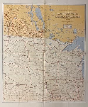
Sectional Map indicating main Automobile Roads between Canada and United States; (Middle West Sheet)
Verlag: Canada Department of the Interior, Ottawa 1926
Anbieter: Argosy Book Store, ABAA, ILAB, New York, NY, USAArgosy Book Store, ABAA, ILAB
Verkäufer/-in kontaktierenVerkäufer/-in mit 5 SternenZustand: Gebraucht
EUR 146,61
EUR 5,18 VersandVersand innerhalb von USAAnzahl: 1 verfügbar
Map. Sheet measures 42" x 36". This extensive road map shows all major automobile roads connecting the United States and Canada. Part of a set of 4 maps divided by region, this map is the Middle West Sheet and depicts Saskatchewan, Manitoba, and Ontario; Wisconsin, Minnesota, North and South Dakota, Nebraska, Iowa, Kansas, Misso…uri, Illinois, and Michigan. It shows state and province boundaries, bodies of water, cities and towns, and national parks. A small inset map is included below the title to show the four sheets that make up the series, and the geographical regions they cover. American Museum of Natural History stamp in upper margin. Folded as issued. The maps were prepared by the Natural Resources Intelligence Service under Director F.C.C. Lynch. Later editions of this map, published through the 1930s, were issued by National Development Bureau under the same director. The series sought to promote tourism in Canada.
Verlag: Canada Department of the Interior, Ottawa 1926
Anbieter: Argosy Book Store, ABAA, ILAB, New York, NY, USAArgosy Book Store, ABAA, ILAB
Verkäufer/-in kontaktierenVerkäufer/-in mit 5 SternenZustand: Gebraucht
EUR 146,61
EUR 5,18 VersandVersand innerhalb von USAAnzahl: 1 verfügbar
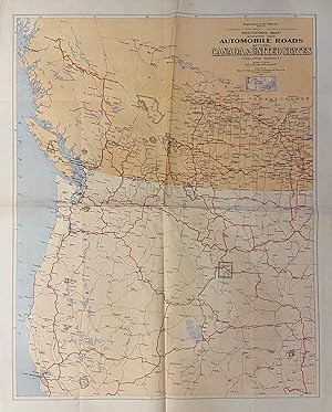
Map. Sheet measures 42" x 36". This extensive road map shows all major automobile roads connecting the United States and Canada. Part of a set of 4 maps divided by region, this map is the Pacific Sheet and depicts Saskatchewan, Alberta, British Columbia, Montana, Wyoming, Colorado, Utah, Nevada, Idaho, California, Oregon, and Wa…shington. It shows state and province boundaries, bodies of water, cities and towns, and national parks. A small inset map is included below the title to show the four sheets that make up the series, and the geographical regions they cover. American Natural History Museum stamp in upper margin. Minor fraying to edges not affecting the image, and misfolded twice along horizontal and vertical fold lines. The maps were prepared by the Natural Resources Intelligence Service under Director F.C.C. Lynch. Later editions of this map, published through the 1930s, were issued by National Development Bureau under the same director. The series sought to promote tourism in Canada.
 Weitere Bilder
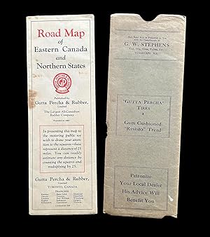
[Gutta Percha Tires] 1929 Road Map of Eastern Canada & Northern States
Natural Resources Intelligence Service, Department of Interior, Ottawa, Canada
Verlag: Gutta Percha & Rubber Limited, Toronto, ON 1929
Anbieter: Harropian Books, IOBA, Nelson, BC, KanadaHarropian Books, IOBA
Verkäufer/-in kontaktierenVerkäufer/-in mit 5 SternenZustand: Gebraucht - Gut
EUR 158,75
EUR 18,98 VersandVersand von Kanada nach USAAnzahl: 1 verfügbar
Map. Zustand: Very Good. A fold-out road map by Gutta Percha & Rubber Limited, titled "Road Map of Eastern Canada & Northern States" measuring 33 x 15 inches wide and folding to an 11 x 3.75 inch wide brochure for motorists. The original storage sleeve is also present with a compliments ad for the Nova Scotia dealer G.W. Stephen…s of Tennscape, N.S. printed at top. Map is toned with a few fold line tears, some brown spots and minor losses near edges ; storage sleeve w. some toning, brown spots and loss, mostly to bottom edge and verso. Map has "Base Map by Courtesy of Natural Resources Intelligence Service, Department of Interior, Ottawa, Canada" printed at lower right corner. The brochure has 16 US city approach maps & 28 Canadian city approach maps on verso along with advertisements for tires and other pertinent information, with the full-sized color map on the other.

Physical and Climatic Map of Manitoba, Saskatchewan and Alberta.
1924 Natural Resources Intelligence Service Map of Canadian Prairie Provinces
- Karte
Anbieter: Geographicus Rare Antique Maps, Brooklyn, NY, USAGeographicus Rare Antique Maps
Verkäufer/-in kontaktierenVerkäufer/-in mit 4 SternenZustand: Gebraucht
EUR 447,83
EUR 14,67 VersandVersand innerhalb von USAAnzahl: 1 verfügbar
Good. Light creasing along fold lines and in margins. Slightly uneven toning and light foxing in margins. Loss at bottom-left corner. Size 21.25 x 32.5 Inches. An impressive large-format map of the 'Prairie Provinces' of Manitoba, Saskatchewan, and Alberta, produced in 1924 by the Natural Resources Intelligence Service of the Ca…nadian Department of the Interior. It both reflected and aided the transformation of these provinces from frontiers inhabited mostly by indigenous people to farmland, settled by Europeans and their descendants, crisscrossed by railways. A Closer Look Coverage includes the provinces of Manitoba, Saskatchewan, and Alberta to the 58th Parallel north, with portions of neighboring provinces and U.S. states. Information relevant for agriculture is recorded, including lines indicating yearly precipitation and the length of the growing season, shading demonstrating elevation, and green lines to delineate prairie, grove belt, and bush country. In addition, survey lines, cities and towns, railways (mostly belonging to the Canadian National and Canadian Pacific), waterways, and other features are marked out in considerable detail. Reserves of land, set aside for national parks, forests, mining, or native peoples (Indian Reserves, abbreviated 'I.R.') are also noted. Outside of the Indian Reserves, indigenous peoples had a degree of rights on most of the land seen here according to a series of treaties (Numbered Treaties) brokered in the late 19th and early 20th century, though these treaties did allow the Crown to utilize lands for railways, mining, and other purposes deemed to be in the public interest. European-descended settlers were initially small in number and primarily interested in trading and extracting resources, such as furs and coal, but farmers arrived in greater numbers in the late 19th century, railways proliferated, and cities, especially Edmonton and Calgary, began to appear. Publication History and Census This map was produced by the Natural Resources Intelligence Service of the Canadian Department of the Interior in 1924. A stamp at bottom-right indicates that it was sold by C. S. Hammond and Co. in Boston. The map is fairly well represented in institutional collections, being held by about twenty institutions worldwide, but has no known history on the market. References: OCLC 44747674.


